mound viewed from ground level by base
Image credit: wideford
mound viewed from ground level by base

the 2 stones at front of mound

?circular arrangement of stones on top of mound

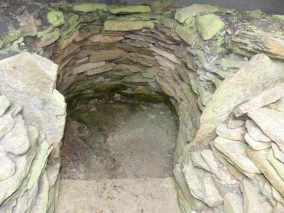
top of possible central chamber
Coming out of Birsay village take the A966 and go down the Vinbrake turn. The Stanerandy Tumulus lies in a field to the left and very soon the road hangs a right. Instead continue onto the farmtrack at the bend. At a house it turns left again, leave your car here if you have not already done so. The Newan cairn lies up by the field fence of the second field from here but you have to go halfway round the outside to reach it as the barbwire is taut and just too high to go over. Where that side of the field meets the track is a standing stone. A little further along the field boundary is another standing stone that points at an angle. It aims straight for the cairn (one of those little anomalies – the place Newan is actually the other side of the Stanerandy Tumulus f.k.a. Stanerandy Stone). Go around the second field edge and there is an ‘Orkney gate’, lying down across the farmtrack at the time of my visit, where you can see a disused quarry.
From this field corner I made my entrance. Still the site disguises herself as a plain grass mound. Only coming closer to do you see a few small stones scatttered around the base . Once on top more is exposed, pattern emerges. Looking on the fence side (the mound doesn’t go to the fence itself) there is a stone 0.8x0.6m with an orthostat 0.5x0.1m sticking a fraction out of the ground to its top left. to the other side of this is a roughly ring-shaped collection of stones 1.6x1.8m the most obvious of which is 0.8x0.3m. Possibly part of this are two apparent orthostats to the direct left at right-angles to each other, like sides of a cist (0.5m along the shorter edge) maybe.
“the stone circle of Randra... formed of a lot of upright slabs of stone with the altar placed in the centre, the ground all round mixed with vitrified cramps locally called smithow cramps” 1903
RCAHMS NMRS No. HY22NE 22 at HY27102777 is probably a stalled cairn of the Orkney-Cromarty type, 48’ diameter x4’ high in 1946 and 14.3m NNE/SSW by 10.6m and 1m in height in 1981. 2.8m ESE/WNW pointing central chamber probably shown by two slabs, one 0.55m long barely visible at the SE and the other at the NW 0.9m long projecting 0.35m. Third, non-earhfast slab on SW side. Reported in 1967 as perhaps recently repositioned. Several large slabs that used to be lying against the fence I did not see on my visit. The first report mentioned three upright slabs.