certain extent of site as enclosed by bank
Image credit: wideford
certain extent of site as enclosed by bank

exposures on side and top of mound, Fairy Knowe [as presently identified] just visible in background

exposure elsewhere on side of mound

exposure atop mound – probably standing stone was at back of this but eroded completely after the several decades since

NW/SE aligned 50x26x12cm split orthostat possibly standing stone

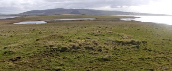
stone pile on an overlooking [presumably natural] bank/mound

mound from features outside bank, standing stone fragment split orthostat bottom left

view from top ; mound edge>platform>ditch>bank

split stone (remains of standing stone) along with middling stones, some embedded in possible linear feature

marsh setting as seen from path to the north

seen from big mound to the NW

central mound of bell barrow

exposed barrow material

view looking south along field fence from gate
Almost opposite the Viewpoint grounds on the right-hand side of the road the footpath is better marked now – though the sign is smaller it now looks to go all the way. So up in front of the house and turn the corner it is the second field from the road. I thought my eyes were playing tricks on me but the fence is indeed ‘missing’ a lower half, and as the ground was virtually dry one not so low roll and I was in (maybe you will find the proper way in further along the track). Not much marshy now. Stands out a little better closer to. A mound like a jelly mould with two tiers, the official record a mound with platform [as with Howe Harper] but they are of about equal depth so I hae my doots. Perhaps the upper part once stood as high as Howe Harper and a covering cairn has been robbed. But what looks to be an excavation on the top indicates it has always been about this height [unless the livestock are responsible]. Like that cairn exposed areas show an earth matrix with some small irregular stones (fragments?) and other stoney material. With the surrounding shallow ditch and encircling low bank it now presents a certain Henge-like appearance. The latest official record castigates the earlier report but I think the conflict arises from confusion about what exactly the dimensions recorded now and then include or exclude [perhaps this is why Hillhead outside Kirkwall has been seen as two banks and a ditch or v.v depending on what area the eye takes in – and ? over time ditches fill in as banks erode]. What looks to be what’s left of the standing stone, a split orthostat with one side above the other as if thumped, is now certainly behind the present bank. One end of this comes up against a (aligned?) short low ‘bank’ with a few middling stones showing and a few more of these in this general area too. Further back there are loose collections of well-sized stones. They don’t look right for a demolished drystane wall but they are over towards the other mounds which have bigger stones yet, some about the ‘burn’. A busy few fields and rather ‘messy’ for a ritual site [on the other hand it doesn’t overlook anywhere itself].
Coming up the Stoneyhill road beside Maes Howe just past where the viewpoint sign is on the left there is a footpath marked on the right. From the ridge on which the house sits with your back to the house look across the intervening field and the mound with its exposed material is there before you. Follow the path and you come round to the gate of the field in which it lies. Even in summer the outline of mound, ditch and bank is fairy obvious. Presently (August) the marshy are is dry. In the field around which the path goes are two or three mounds covered in grass that stand higher than the bell barrow, and in the tops of at least two are the tell-tale signs of antiquarian barrow-digging. I came by the side opposite the viewpoint sign aong a couple of ruts, which I do not recommend as the marsh plants stand high and their lushness hides the much pitted surface of the ground – even though dry you do not know from one step to the next how far the foot will go. I was strongly put in mind of going to the Knowes of Trotty. Then again, taking the ‘marsh’ into account reminded me of a 19th century antiquarian account of digging mounds at Langadae (Burn of Langa Dee) : “The burn or water courses have been conducted in a meandering manner about each mound.“, and further “On each of these mounds there is and was a lump of white quartz ” brings to mind the disintegrating stone of the bell barrow here.
Graves were found at a place called Fairy Knowe which has been identified with the plain mound Quoyer visible from here in the next field east, for want of a better candidate. Given the pits dug into the Vola platform this would seem a much better prospect.
RCAHMS NMRS no. HY31SW 7 at HY31471395 has been re-assessed a few times, the large size of the central mound and the lack of sharply defined features leading to its being currently classified as an unusually proprtioned bell barrow rather than a disc barrow like Wasbister. This N/S aligned barrow was 102x85’ with an irregular ditch of between thirteen and twenty-one feet. The platform and ~17.4m diameter mound both presently stand a metre high, and there were the remains of a 5” thick earthfast stone on the latter with the same orientation.