aerial view of present state, above the line shows as dark green and below light green
Image credit: wideford after Google satellite
aerial view of present state, above the line shows as dark green and below light green

prehistoric settlement mound with 13thC buildings

sites on 1880 25” to mile map

one of several brochs in a face-off with Rousay

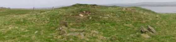
The 1st 25” map show’s Peter’s Kirk (HY32NW 12 at HY33742870) on uncultivated land between the low cliff and an obtuse angle wall, west of which ‘enclosure’ are the legend Burial Ground and a due N/S aligned oval Cairn (apparently banked) slightly bigger than the kirk – another smaller building is shown at the edge of the southern wall segment near the corner. The stone cairn (HY32NW 16 at HY33712870) is presently described as turf-covered, about 9mD by 0.7m in height and marking the edge of a settlement mound at whose highest point the kirk is. Though in 1967 Ordnance Survey were unable to classify it, as the result of what they considered severe mutilation, in 1981 the SMR talks of what might be the concave inner face of a structural wall on the north side, formed by a row of edge-set slabs. Also on the settlement’s edge, east to south-east of the kirk, are several irregularly placed erect stones. These are tentatively described as grave-markers but could be from an underlying structure [as with the broch features diggers have found at Warebeth Cemetery on occasion]. To the north-east of the site the cliff cuts through the settlement to reveal traces of prehistoric structures up to three metres in depth, described as unsurveyable by O.S. in 1967. Alongside is kitchen-midden.