Details of Hillfort on Pastscape
Iron Age hillfort partly levelled in 1931.
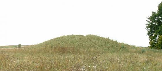
A field survey carried out in 1993 by RCHME found the site to comprise a shallow sub-circular earthwork enclosing an area of about 1.8 hectares. The earthwork consists of a bank with external ditch, and hints of a counterscarp. Vestiges of a `celtic’ field system evidently underlying the enclosure remain, and spread north. Also noted were a number of parchmarks which probably represent the position of small pits. The hillfort may have been known as Cissanbyrig, one of the unidentified forts of the `Burghal Hidage’.
(SU 15195387) Chisenbury Camp (LB). (1)
A roughly circular IA ‘A’ hill fort, levelled in 1931 when the airfield was extended. Chisenbury Trendle as it was known, is
described as having an area of 5 acres and circumference of 594 yards. The rampart was 16 feet deep, though this seems doubtful as prior to levelling the best preserved, and seemingly little cultivated, portion was less than 6 feet high. Hoare believed the entrance to be in the south, where vestiges of an outwork were visible. Finds, in Devizes Museum, include a considerable amount of pottery, a piece of loom weight, three worked discs of chalk, a bone ‘counter’ and a human jawbone. Chisenbury Camp may be “Cissanbyrig”, one of the unidentified forts of the ‘Burghal Hidage’ (4).
Visible on AP. (2-5)
The rampart of this settlement remains as a spread bank 0.3 metres high, except in the south, where a scarp remains up to 1metre high, in a ploughed field. There is no trace of an entrance or of the outwork, either on the ground or on OS APs. Locally called “Chisenbury Camp”. Surveyed at 1:2500 from OS APs. (6)
Surveyed at 1:1000 by RCHME field staff as part of the SPTA Project (see archive report for further details). The site consists of a shallow sub-circular earthwork enclosing an area of about 1.8 hectares, and which consists of a bank with external ditch, and hints of a counterscarp. Vestiges of a `celtic’ field system evidently underlying the enclosure remain, and spread north. Also noted were a number of parchmarks which probably represent the position of small pits. (7)
--------------------------------------------------------------------------------
SOURCE TEXT
--------------------------------------------------------------------------------
( 1) Ordnance Survey Map (Scale / Date) OS 6” Prov
( 2) The Wiltshire archaeological and natural history magazine (M E Cunnington) 46 (1932-4) Page(s)1-3
( 3) General reference Ancient Wiltshire, 1. 192 (R Colt Hoare)
( 4) Medieval archaeology : journal of the Society for Medieval Archaeology (N Brooks) 8 (1964) Page(s)74-90
( 5) Aerial photograph AP CPE/UK/1821/3146
( 6) Field Investigators Comments F1 MHB 13-MAR-73
( 7) General reference D Field, D. Mcomish/02-FEB-1995/RCHME:SPTA Project