Avebury 30a, twin mounds inside a single ditch.
Image credit: A. Brookes (24.3.2017)
Avebury 30a, twin mounds inside a single ditch.

Avebury 31 and 32, with the Ridgeway running across the ridge behind.

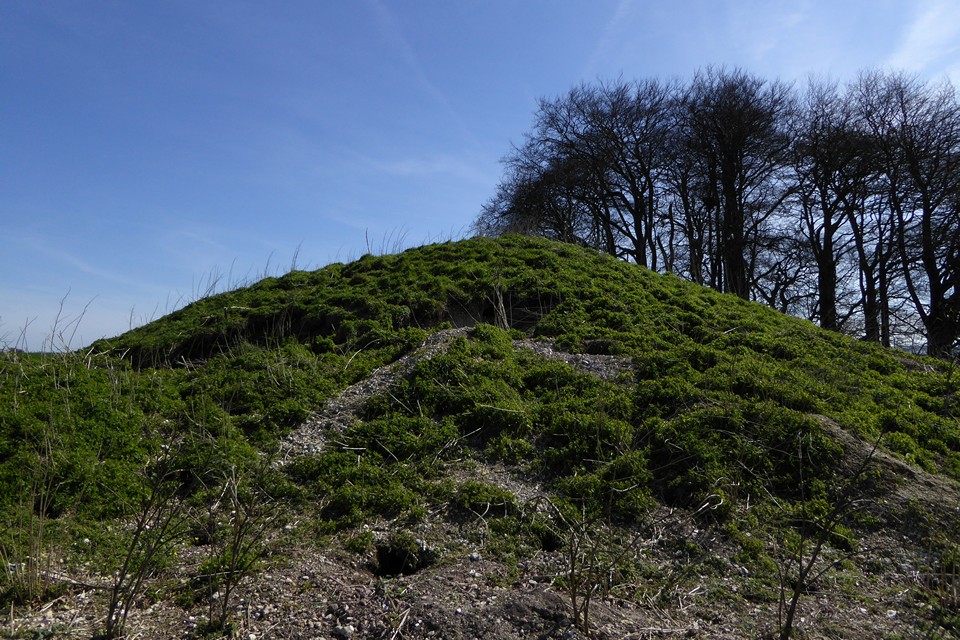
Avebury 32.

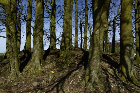
Avebury 32 beneath its crown of beeches.

Avebury 32 bowl barrow, Avebury Down. The highest hills of Wiltshire on the skyline, more terrific barrows on Overton Hill beneath the beeches in the middle distance, West Kennett Avenue and Waden Hill over on the right.
The north side of Avebury 31, showing damage from burrowing critters.

Avebury 31 bowl barrow, Avebury Down. Avebury itself is extreme left of shot.

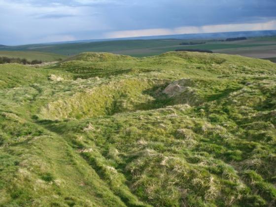
Looking back down the Herepath towards Avebury, from Avebury Down. The small unnumbered barrow at SU11807052 can be seen in the ploughed field on the left. Oliver’s Castle, Morgan’s Hill and Cherhill are all visible on the skyline.

Small, unnumbered round barrow at SU11807052, on the south side of the Herepath.

Avebury 32 (left, under the trees) and Avebury 31 (right), from the Ridgeway.

The Herepath trackway cuts through Avebury Down between the barrow groups.

Avebury 35, not as impressive as its neighbours to the north.

The easternmost barrow in the group, Avebury 40.

Avebury 39 round barrow.

The very substantial Avebury 39 round barrow.

Avebury 38 bowl barrow, more easily seen from the north.

Avebury 38 bowl barrow, from the south.

Avebury 37 bowl barrow, now situated inside a nature reserve.

Avebury 37 bowl barrow at SU11257097, with Avebury 38 beyond.

Avebury 36 bell barrow at SU1105770927.

Avebury 36 bell barrow, looking SW towards Morgan’s Hill and the trees on Furze Knoll.

Using Grinsell’s numbering, Avebury 35 (foreground, overgrown SU11337049) and Avebury 36 (skyline SU1105770927). Seen from the Herepath.

... and looking back...

Looking down towards Avebury...

Up by the Barrows

Northwards along the Ridgeway towards the direction of Avebury
Details of site on Pastscape
(Centred SU 11347100) Tumuli (NR). (1)
‘A’ (SU 11257097) Avebury 37 -Bell(?) barrow, mound diam 48’, height 5’; Merewether in 1849 (barrow 3). Primary (?) cremation and remains of small bronze dagger which had been burnt. B & T arrowhead found. (Grinsell qualifies his classification by saying that apparent bell form may be due to removal of material from circumference by ploughing. Merewether says that it was a bowl barrow).
The barrow was dug into by Merewether on August 10th 1849. His account in full runs as follows: “Somewhat smaller in dimensions than the others. Large fragments of bone, teeth, burnt wood; at about 8 feet deep a cist, 18 inches diameter, formed in the natural chalk bed, containing burnt human bones and two small pieces of bronze; a smooth stone tapering towards one end, which had been broken off – it may have been a spear-head, and a rather large flint arrow-head, were discovered in the progress of the excavation, as well as a small one of iron”. Merewether described it as a bowl barrow, and provided illustrations of the artefacts, although the bronze fragments and the tapering stone object are not easily identifiable.
Identification of the bronze fragments as representing a dagger is far from certain. Merewether made no such identification, and his published drawings are little help. Goddard, in his 1911 corpus of Wiltshire bronzes, appears to include these items under the heading “Fragments of Bronze, indeterminate or undescribed...” (corpus no. 302), yet a couple of year later referred to “two small pieces of bronze (knife-daggers?)“, the wording suggesting he was guessing. Grinsell more confidently asserted that Merewether had found the “corroded remains of small bronze dagger whichhad passed through the fire”, though no further authority is given for this statement. Its subsequent history is unknown, and it is not mentioned in Gerloff’s corpus of British Bronze Age daggers. (2-3, 6-8)
‘B’ SU 11297100 Avebury 38 – Bell(?) barrow, mound diam 63’, height 7’; berm width 9’; ditch destroyed. Excavated by Merewether (barrow 4). Primary (?) cremation in MBA collared urn. Rim of another collared urn found 2 1/2’ from top of mound. (Grinsell has same qualifications to classification as in Avebury 37).
Merewether’s account of the excavation, on August 11th 1849, is as follows: “At a depth of about 2ft 6in a considerable fragment of a large coarse urn was found, ornamented with plain hatched lines rount the top. At the depth of 5 feet, a cist, formed as usual in the chalk, was discovered; this was 2ft 6in in diameter, the same in depth; it contained in fragments, but as it had been originally deposited, in the centre, a large plain urn filled with burnt human bones; the urn was 13 inches high.” Merewether was quite explicit in describing the mound as a bell barrow, as were the Ordnance Survey. Grinsell was more cautious. (1-5)
‘C’ SU 11357099 Avebury 39 – Bell barrow, mound diam 84’ height 6 1/2’ berm width 14’; ditch destroyed.; certainly a bell barrow with berm wide and well preserved.
There is no report of Merewether having excavated Avebury 39, which seems a little curious given its size and proximity to other barrows dug into by him. However, in this area, he refers to “a range of five large barrows” but only describes the results of digging four. A fifth is described merely as having “previously been opened”. Here he may well be referring to Avebury 39. Thus the shallow depression in th summit of the mound referred to by the Ordnance Survey may well relate to a pre-1849 antiquarian excavation. Grinsell’s report of the ditch being “destroyed” by ploughing by 1950 is curious given its clear presence 25 years later. (1-5)
Additional detail for one of the barrows (SU 1134 7098), including a central hollow, is visible on lidar and was mapped as part of the Avebury WHS Lidar and NMP Review.
‘D’ SU 11417099, Avebury 40 – Bowl barrow, diam 15 paces; height 5’. Excavated by Merewether (barrow 5). Primary (?) cremation in a large cist on the natural surface of the ground, covered with black substance like pounded charcoal. (2-3)
Merewether dug into the barrow on August 11th 1849. His account of the excavation is as follows: “This barrow, the last of the five eastward, did not produce in course of its excavation the ordinary quantity of fragments of bone, teeth, or pottery, but was unusually compact and close in its materials; at about 7 feet deep, – the level of the adjacent down, – we came to a cist formed in the natural chalk, filled with burnt human bones, the produce of apparently more than one body. This cist was the largest of those I have met with of this kind; but there was no urn, nor any fragment of pottery, to indicate that the bones had been deposited otherwise than they were found, – they were covered with the black substance like pounded charcoal.” Merewether clearly refers to this barrow as a bell barrow, yet both Grinsell and the Ordnance Survey describe it as a bowl barrow. (1-5)
A. SU 11257097; A bowl barrow 15m overall diameter and 1.3m high. Ditch ploughed out. Some mutilation on the SE gives the slight
suggestion of a bell barrow.
B. SU 11297100; A bell barrow 40m overall diameter, has a mound 2.7m high above a wide, 0.2m ditch which is ploughed out in the N.
C. SU 11347099. A bell barrow, overall diameter 54m. Mound 2.6m high; berm 4.5m wide. The ditch, average 8.0m wide is now 0.2m deep. There is a shallow depression in the mound summit.
D. SU 11417098. A ditchless bowl barrow, 15m overall diameter and 1.1m high. Published 25” surveys revised. (4)
All four barrow mounds were mapped at 1:10,000 from APs by the Fyfield Down and Overton Down Mapping Project. No additional information was recorded. (5)