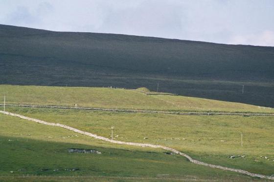
view from road looking down to dividing fence
Image credit: wideford
view from road looking down to dividing fence

roadside view parallel to dividing fence of ‘upper’ section

cairn seen from top of hillock opposite looking uphill

‘upper’ section seen from hillock opposite

part view of cairn looking uphill
‘upper’ section seen from downhill side of dividing fence

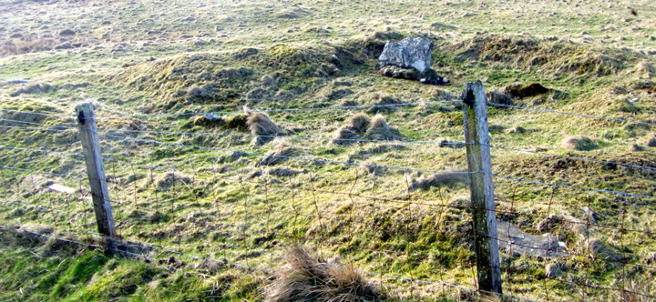
‘upper’ section showing stones near dividing fence

view of ‘upper’ section looking across to road

view across ‘upper’ section from dividing fence

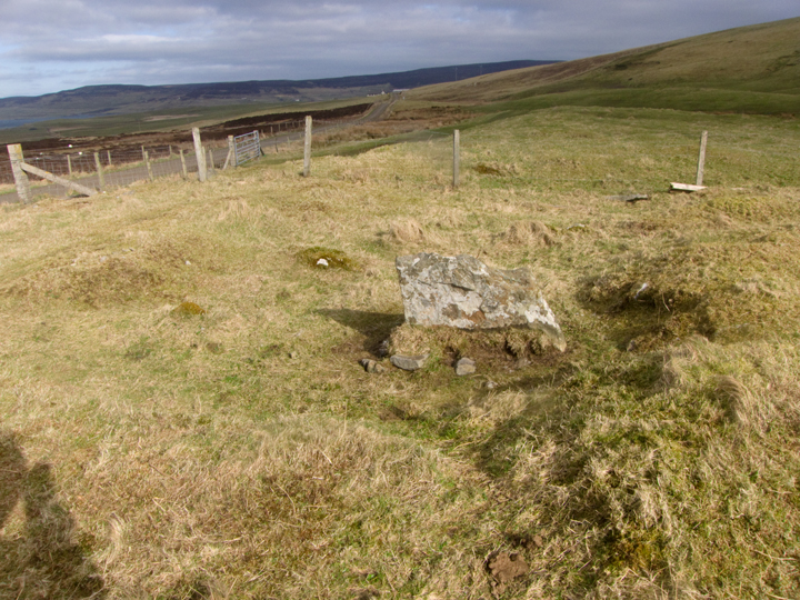
area around Redland Standing Stone stump
view from inside looking to dividing fence

The Redland/Keek standing stone (RCAMS 273 at HY37992486) was, and stil is, the most visible piece of Redland South’s stonework
In Evie village opposite the ‘new’ school is the Aikerness road with a sign for the Broch of Gurness (originally the Knowe of Aikerness). Going down the road where the farm on your right ends Redland South is in the second and third fields down – when I went three-and-a-half years ago, taking photos from the roadside bank, I didn’t realise that the bulk of the cairn lies in the lower field because I went purely by the Pastmap marker. Certainly the ‘upper’ section is the most visibly man-made because of the large excavation pit around what had been known as the Redland standing stone, and looking across to Vishall Hill two long shapes look much more like burial mounds (they are above where Keek once stood). This is because the cairn sits on a the flat top of a natural mound rather like later cists were placed in false crests and rises. Indeed it feels as if the ‘upper’ section is a seperate entity as with the Head of Work. The lower field’s remnant (entered by another gate) is rather unimpressive, especially as with a warming climate the protruding stones detailed in the record are hidden by grass. I came across then haphazardly, and it struck me that rather than ragged stumps these are original tops – I don’t see why the standing stone alone would have survived levelling.
Visited 9.6.12
Directions:
Right next to the minor road which leads to the Broch of Gurness off the A966.
Access is via a quick hop over the fence.
A mangled grass covered mound which has one large stone sticking out of its centre.
Several smaller stones are sticking out of the grass.
Canmore states:
‘This turf covered cairn has been greatly robbed and disturbed by the intrusion of structures of a levelled farmstead. It possibly measured 27m in length. Cairn debris remains to a height of 0.6m’.
Redland South cairn, NMRS record no. HY32SE 17, was at least 27m long by 12m wide. Aligned ESE/WSW it sat on the edge of a shallow NW/SE plateau ~83m x ~15m, a natural dip on the NW side marked by an old track. A long stalled chamber is marked by eight protruding stumps. The compartments were most likely some 1.65m, though there was a longer compartment or two shorter ones between slabs 6 and 7 and the end compartment was also somewhat longer. The Redland Standing Stone and its partner formed a stall 4.1m from one end of the chamber [either the other stalls also once stood to a man’s height and they are much reduced or there was a considerable variation in height, though what comes to my mind is Weyland Smithy]. It is thought possible that the cairn continued beyond the NE cairn material. Also there is a 1.3m long 0.4m high orthostat SE of the chamber not following its axis.
RCAMS 273 the Redland standing stone was, and stil is, the most visible piece of Redland South’s stonework. Until the 1880s, when a farmer smashed it to stop livestock using it as a rubbing stone, it stood about 2m high. The irregularly topped stump is described in the late 1920s as 12 or 16” high by 3’ broad by 6” thick, and aligned ENE/WSW like Staneyhill. At that time the 4’8” upper fragment, tapering to a 2’7” squared off top, lay where it fell. In 1929 the ground around the stone was described as irregular with some small earthfast stones with the smaller stump of another standing stone mere feet away. So the excavation we see here is 1930 or later. More to follow on the cairn proper when I’ve sifted through photos from three visits. Cairn is in two fields on your right as you go from the Evie road to the Broch of Gurness