Taken from the Cornish Ancient Site....
This is a reconstructed barrow in a class of monuments called entrance graves or chambered tombs. It consists of a circular kerb of stones with an entrance; Brane barrow is similar.
Approximate Neolithic dating 3000-2500 bc and has a diameter of 4.95 m and a height of 1.5.m approximately. It was excavated in 1984, when a primary deposit in a pot was discovered, it also had, interestingly enough, turf and topsoil in the chamber - ritual deposits?
Entrance passage was deliberately positioned to face the midwinter solstice sunrise (same as Brane Barrow).
http://www.cornishancientsites.com/Lanyon%20Quoit.pdf
|
Again Nicholas Thomas....but he is good on description.
"Battlesbury is irregular in shape, its defences following the contours of the hill. Its triple ramparts, double on the S.E. enclose 23.1/2 acres. There are entrances with outworks N.E. and N.W, Pits found within the fortifications contained late I/A pottery, the hub of a chariot wheel, an iron carpenter's saw and a latch-lifter for a hut door. These indicate permanent occupation and a date in the 1st C. That its inhabitants came to a violent end is indicated by the discovery of many graves containing men, women and children outside the N.W. entrance...It is not known whether roman legions put people to the sword, or whether this was the result of inter-tribal warfare before the roman conquest".
A Guide to Prehistoric England.
|
According To Nicholas Thomas (A guide to Prehistoric England) Rhiannon..he says this about Scratchbury;
"This superbly placed hillfort, looking across at Battlebury Camp, encloses 37 acres within a bank and ditch with a counterscarp bank. Its irregular four-sided shape follows the contour of a steep hill. There are two entrances on the E side, and possibly a third on the N.W.. Remains of a much smaller inner earthwork of much smaller size can be seen. This resembles the earlier enclosure at Yarnbury and has recently been dated 250 b.c...He goes on to say that there is a romano-british or later ditch, running E/W, and turning S, sharply at the SW corner of the hill-fort overlies the I/A eartworks. Main ramp[art must have been built in the 1st C. BC"
|
The following extract taken from Paul Ashbee's "Barrows, Cairns and a few imposters" highlights an interesting longbarrow with a mortuary enclosure. There seemed to be no evidence of any timber remains under the barrow itself amongst the flints when it was excavated, but that 'the flints remained in a roughly ridged form'.
The collapse of the barrow on itself, timbers decaying over time, had forced out 'stacked long bones'; skulls were also found in an 'exploded' condition. The barrows length was 135 feet.
"What did barrows look like when first raised? At Fussell's Lodge long barrow, near Salisbury, the discovery of post-holes in a lengthy, trapezoidal structure showed that initially there had been a structure resembling a Neolithic long house of the type found widely on the Continent. Subsequent long barrow excavations showed that this formula was widely followed. These surrogate long houses contained deposits of human bone that were added to and subtracted from, for more than a millennium, and rites pertaining to ancestors and fertility were no doubt performed. Long barrows, the long houses of the dead, should be regarded as shrines rather than mausolea."
http://www.britarch.ac.uk/ba/ba32/Ba32feat.html
The 'long houses of the dead' are explored by Richard Bradley in his book 'The Significance of Monuments'.
|
Further to Rhiannon's notes, (reference later) Garn Turne is one of three megaliths clustered around the hamlet of Colston, and apparently seem to be the end of the monuments that delineate the Myndd Preseli group....
It is an enormous capstone Nash says, one of the largest in Britain(weighing more than 60 tons,) now collapsed.
It had a 'v' shaped forecourt similar to Pentre Ifan and Irish court tombs, facing north-east toward the large rocky outcrop. Apparently it has a large, pointed sandstone conglomerate block within the centre of the forecourt (think Pentre Ifan started with one singular stone).
It's 'hidden' or at least merges into the stony outcrop that surrounds it, a feature of a lot of the cromlechs round here, and of course the siting near to a distinctive outcrop; the 'gorsedd' maybe of Julian Cope fame...
ref; Neolithic Sites of Cards, Carms, and Pembs. by Geo.Children and Geo. Nash
|
The "Kyber Pass".. Close to Clifton Suspension Bridge, 3 promontories have been fortified by earthworks, these three camps are within 800 yards of each other. Apparently all were identical in design, which could point to them being contemporary. Dated to 300bc to 100 ad, some use in medieval period.
Stokeleigh Camp faces Borough Walls across a short valley. Two bank and ditches, with additional banks on the N.W, and also at the S.E. overlooking Nightingal Valley. Entrance close to S.W. corner, area enclosed about 6 acres. Taken from....
Guide To Prehistoric England - Nicholas Thomas
Reverend Skinner had a theory that the Wansdyke might have been extended in this direction.
|
Tunley Cromlech destroyed. Identified by Skinner as a capstone with two supporting stones, but was already being broken up by 1812 for road material. Skinner says;
"there was a cromlech on the highest point to the east of Tunley Camp"
Jodie Lewis (Monuments Ritual and Regionality) Neolithic of north Somerset says, that it could either have been the remains of a Cotwold Severn barrow or a simple portal dolmen.
|
A Poem addressed to the destructive process of the new road being built through Tara's historic landscape. Sacred to prehistory and to the history of Ireland, for this a few protestors will go to prison, people will write letters in vain to newspapers, and politicians will procrastinate and write their lies...... it is wise to remember that progress has a heavy boot to wield and often hasty and ill-concieved laws to underwrite the handiwork of the bully and developer...... the poem is taken from the Save Tara site.
Song to Progress
no swan , no snail must stop this dash
to tear around with wads of cash
and get at speed from A to B
and not to Dawdle pointlessly
So - move Along ! - wont it be Grand !
when Ireland's just like Legoland
my work will only be Complete
when Boyne to Liffey's all Concrete
and Shoefayre stands where Fianna fell
and Leisureworld - and Next as well
IKEA - if we're really lucky
and drive-in Chicken from Kentucky
THIS is what we want to see
not grass and trees and history
but modern stuff - and this and that
and things on which we can put VAT
and if you want to get more slim
why walk ? - just buy a Multigym
When we're encased in cans of steel
both hands attached to steering wheel
and eyes fixed on the road ahead -
we may as well be effing Dead
this stretch of road - built over bones
is one of many thousand clones
did we just pass the Lia Fail ...?
it could be anywhere at all
just sit like this an hour or two
as if you've nothing else to do
and work and work all day and then
stay sober and drive back again
a quarter million cars a day
is JUst what Dublin needs I say !
aMAZing what they get to pay
to park the things - we're making hay !
cos there'll be car parks to be built
and lots of pockets to be filled
there'll be no end to means and ends
cos its so nice to have good friends
there is a railway - but you see
it closed in nineteen sixty three
it could be opened up again
but that somehow doesnt seem to happen
Mad Suibhne sitting in his tree
is keeping feathered company
he watches as the human race
is drifting loose from sense of place
and capsulated in a car
of who and where and what we are
so every weekday without fail
we slave to buy a better jail
or hang on to the one we have
by hook and crook and tooth and nail
and so far is now the space
and so far have we come apart
we even think to cut the Heart
"Progress"
?
though feathered Suibhne looks absurd
he doubts if it's the proper word
marcellavee 1/08/07
|
The following taken from George Witt's Archaeological Handbook of the County of Gloucester 1882; he places it under the name of Littleton Drew Barrow.
"This was first noticed by John Aubrey in his MS., "Monumenta Britannica," in the seventeenth century; it was called "Lugbury." It lies in the parish of Nettleton, but close to Littleton Drew, in Wiltshire, just outside the boundary of our county. •It measures 180 feet in length, and 90 feet in breadth, its greatest elevation being six feet. Its direction is nearly due east and west. There are three stones at the east end, on the slope of the barrow, thirty feet from its base; the two uprights are •six feet six inches apart, two feet thick, and four feet wide; one is •six feet six inches high, the other •five feet six inches. Resting on the mound and leaning againstº the uprights is a large stone, •twelve feet long, six feet wide, and two feet thick. A cistern was discovered •about sixty feet from the east end, containing one skeleton. Another cistern was found on the south side. Three other cisterns were also found, •about ten feet long, four feet wide, and two feet deep, formed of rough stone. The total number of skeletons found numbered twenty-six. Several flint flakes were also discovered. "
|
"There seem to be few genuine traditions attached to the Horse, for its 'traditional' attribution to King Alfred is almost certainly due to Francis Wise in 1738 and is not mentioned by Baskerville or Defoe"
Can't let that pass, the person who wrote it had obviously not read Jacquetta Hawkes on the subject or H.J.Massingham - two favourite books, if you want to read about the emotional love affair people have with their English countryside ;) look no further than early 20th century literature.
The scouring ceremony is first mentioned by Aubrey and the best early record dates from 1677 when Baskerville wrote;-
"Some that dwell hereabouts have an obligation upon their hands to repair and cleanse this Lande marke, or else in time it may turn green like the rest of the hill and be forgotten"
The Uffington White Horse sired nearly every other 18th century chalk horse in the district!
He holds within his image, the beautiful celtic curvilinear design to be found on the horse furnishings around this area, he can be called a Saxon horse because of association with King Alfred and white horses, and of course he belongs to St.George and his dragon. His various mythical and magical guises link him to gods and harvest ceremonies....
|
Wayland Smithy is a place that has a haunting atmosphere, and as I am reading a Peter Please book at the moment, he is a 'wayfaring soul' of Bath much given to walking the Wiltshire countryside,I thought it would be nice to recommend his book; "The Chronicles of the White Horse", written for children and adults it is a good book and the story culminates at Wayland's Smithy...
In the following quote he invokes the bloodied hooves of the horse pounding between the standing stones, calling the dead and all things that have ended back into the barrow....
"I was at the door of the manger, the horseshoe chamber of Waylands. Not a grave, but a door,
a passage between two worlds; a spirit cavern for the dead and all that is dying....
and on a happier note;
"I heard the bells ringing in Wayland's Smithy. I heard the larks above White Horse Hill.I saw the flowers opening. I saw the barley growing. I saw the lambs in the meadows. I heard the earth singing. And even when the last of the light had faded to a pinprick in the sky, and the last of the stars had disappeared.....
Myself when I wrote about it found it an utterly peaceful place but I expect it was because there were no people around - dead or alive ;)
|
"Neolithic Dew-ponds and Cattleways." The brothers, Arthur and John Hubbard, wrote this lovely book, though its facts are slightly on the wild side, at the beginning of the last century, they diligently recorded the cattleways and dewponds around such places as Cissbury, Chanctonbury and Maiden castle hill forts. Wolf platforms; Maybe they got it wrong, but wolves, can you not see them, like great lions guarding the gates of Martinsell hillfort, really does send the imagination racing.
"The month which we now call January our Saxon ancestors called wolf-monat, to wit, wolf-moneth, because people are wont always in that month to be in more danger to be devoured of wolves, than in any other season of the year; for that, through the extremity of cold and snow, those ravenous creatures could not find of other beasts sufficient to feast upon"
Richard Verstegan
"Restitution of Decayed Intelligence in Antiquities 1673"
|
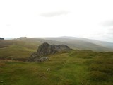
As you can be see, I didn't find the cromlech, it is apparently but a few metres east of the rocky tor/outcrop on above photo which obviously gives the cromlech its significance according to Neolithic Sites of Pembs., Children & Nash). To get nearer the outcrop would have involved pushing through three lots of barbed wire plus climbing stone banks - something the Welsh farmers really get cross about!
Given its narrative within the landscape, (some cromlechs are hidden from view) this one, according to Children, its importance is linked with the rocky outcrop. It was not a visual concept, such as Carreg Samson maybe, but one constructed through ritual and symbolic knowledge of the landscape.
My interpretation of what he means by this, is that the shape of the outcrop is similar to the shape of a burial mound. Similar tor like shapes are found on the Preseli mountains - natural places being seen as the burial stones of long dead ancestors.
|
Neolithic mine shafts; to add to Rhiannon's post, my book says there is a line of 39 shafts to be seen outside the south entrance of the fort. Some of the shafts go down 40 feet through the chalk, cutting through 6 or 7 seams of flints, with galleries radiating horizontally from the main shaft. Apparently there were two burials down there (one maybe accidental fall), no serpents though.
Iron age;60 acres roughly egg shaped, with two banks, and ditches, 250 bc. In its first form the chalk rampart stood 15 feet high and faced with vertical timbers, also had tie beams as well. The ditch, separated by a berm, was 10 ft deep into the chalk and about 25 feet across.
Fell into decay after 200 years, and was ploughed in the roman period, with the iron age 'celtic' fields in and around the fort. Then refortified for a short time at the end of the roman period against the Saxons this time, they won the day of course because there are saxon burial mounds on the Chanctonbury Ring Fort.
A guide to Prehistoric England Nicholas Thomas;
|
According to Nicholas Thomas - A Guide to Prehistoric England, this is a hill-slope fort and boundary ditch. He goes on to say that it is interesting because it is the only example in Wessex of this type. He also says its less defensive more to do with the herding of cattle, similar to ones found in Cornwall, Devon and South Wales. Date approximately 2nd-1st Century bc.
Two main earthworks - outer one, kidney shaped enclosing 12 acres, and an inner one roughly circular, but not concentric with the outer one, 2.1/2 acres.
A series of ditches radiate out from the Rings, could be late B/A but more likely iron age, being a 'celtic' field system, apparently the west ditch is probably the track down to the river for watering the cattle presumably...
|
The earthworks enclose about 15 acres. Two lines of ramparts on all sides except the north, which is protected by the river Frome and only has one (though two ditches). Original entrance through the east inner rampart, close to the mouth of the railway tunnel (quoting here from 1960's book). Its one of those interesting hillforts that has timber revetments on the inner rampart, which is built of chalk and has a berm between it and the ditch. Probably 13 foot high, with a corresponding depth for the ditch. This work carried out 3rd century BC (maybe contemporary with Maiden Castle).
Then just before the roman conquest an outer ditch and bank was added, and the inner bank widened and heightened, AND a limestone parapet was built on the crest.
There is a story waiting to be written here.... apparently, according to the book, those responsible for this reconstruction were the Durotriges tribe who had seized Maiden Castle. Poundbury was important because it overlooked a ford across the river.
ref;A Guide to Prehistoric England - Nicholas Thomas- Batsford 1960.
|
A hillfort and a Roman signal tower?. Triangular in plan, its defences encloses 4 and half acres. On the N.S. and E. the earthworks comprise 2 banks with a ditch between them. At the S.E. level ground has caused the building of four ramparts with ditches outside them.
Maybe Roman bit; At the S.W. earthworks have been altered at some later stage so that an almost square earthwork has been constructed in the angle of the inner bank.
Within the hill-fort to S.E. are a group of about 9 circular depressions could represent site of huts B/A? south west of them is the mound of a bronze age bowl barrow.. Presumed Date; 250-50 bc.
Taken from A Guide to Prehistoric England - Nicholas Thomas 1960.
|
The following information is taken from Jodie Lewis - Monuments... The Neolithic of Northern Somerset..
3 circles, 2 avenues, a cove and a henge, with of course the geo-phys'd timber circles. Great stone circle has a dia; of 112.2.m and has 26 stones, the great avenue is 49 m long and 10.4.m wide. It could well be that the timber, stone and earth phases are contemporary, with the inner sacred centre of timbers (either in situ/or rotted) being the focus round which the stone circle and the henge (for viewing) were viewed. The open/closed nature of the central timber structure could be augmented with hurdles/planks for hiding rituals. But of course timber and stone periods might be different, the stone circle just acknowledging the sanctity of the older timber circles
North-east circle is 44 m to the n/e and has 8 very large stones, the largest in the complex, diameter of the circle is 29.6.m. One of the things to be noticed about these stones, no female/male typology, just large square blocks of stone. Leading from this circle is the n/e avenue with 7 stones. Apparently in the centre of this circle were 4 anomalies (maybe pits) sharing an alignment as the four pairs of stones that are the circle, but these circles had orchards around them so therefore tree remains cannot be ruled out.
The South west circle is recorded in 1881 as having some of its stones removed for the fencing round an orchard, so presumably stones have been moved around. It lies 137,2 m s/w of the great circle, has a dia. of 44.2m and is comprised of 12 stones, and Jodie Lewis goes on to say stones have almost certainly been moved around. Again geophysics noted 3 concentric rings of pits within this circle, so again presumably another timber circle within the bounds of a stone circle.
Note; this is written down, not just for anyone reading it but for those two young men sheltering from the cold wind behind a stone (one playing some pan pipes) when I was there last autumn and when they asked for an explanation - did my best at the time but did'nt have the book...
http://web.arch.ox.ac.uk/archives/underhill/viewarchiveslide.php?imageID=26&albumID=1 map plan in the Underhill Archives showing the Avenue
As a note; Stanton Drew circles do not seem to relate to any outstanding landscape feature, such as Maes Knoll, but are focussed towards the river Chew, Jodie Lewis makes the point that at certain times of the year, due to flooding, the river turns red from the clay and soil leaching into the river., this would give it a significance as a meeting place (there is lithic scatter found near the site). This river also joins the River Avon further down at Keynsham were ammonites are found, such as the one at Stoney Littleton.
Part of the henge can still be seen in the foreground of Morfe's photo;
http://www.themodernantiquarian.com/post/44696
|
Well, according to this link, http://www.sacredsites.com/europe/england/cerne_giant.html.
If you take a sightline/alignment on May Day you should see the sun coming up;
to quote; "a sightline taken up the giant's penis on May Day points directly at the sun as it rises over the crest of the hill"
So to verify this fact if anyone is around at dawn on May Day next year - please check..
|
All these eight barrows were investigated by the Reverend John Skinner in 1815, and all barrows produced one or more cremations. Some of these contained Early Bronze age urns and were covered with stone slabs (similar to Lansdown barrows cemetery). Three barrows had bronze daggers, one in a wooden sheaf. One barrow contained a rich burial which included beads and other objects of amber (maybe faience) and a miniature incense cup. There are a further two, much larger barrows, located north of the main cemetery.
Taken from;
British Barrows (A Matter of Life and Death) by Ann Woodward.
|
|
http://northstoke.blogspot.co.uk/
|