|
|

|
|
Ffyst SamsonChambered Tomb
|
|
|
|
Images (click to view fullsize) |
|


|
Fieldnotes |
|
|
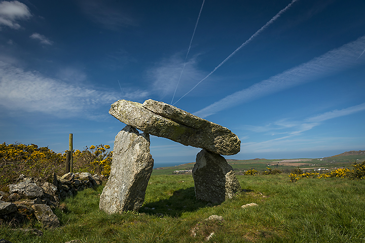
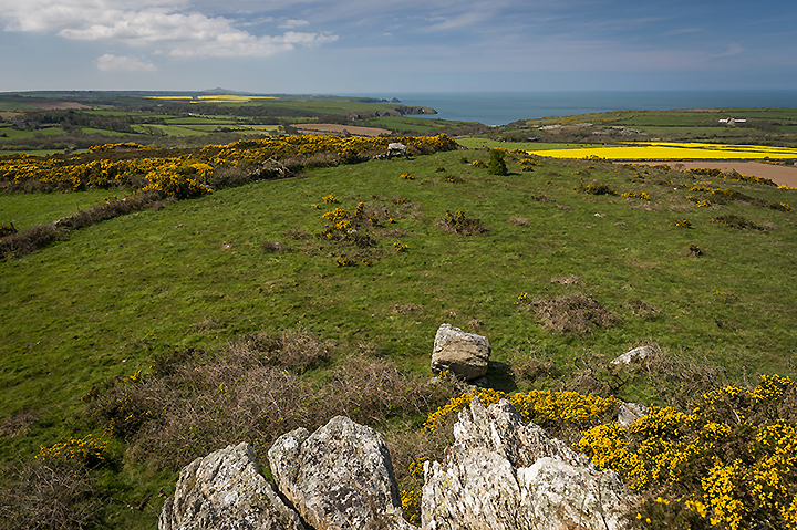
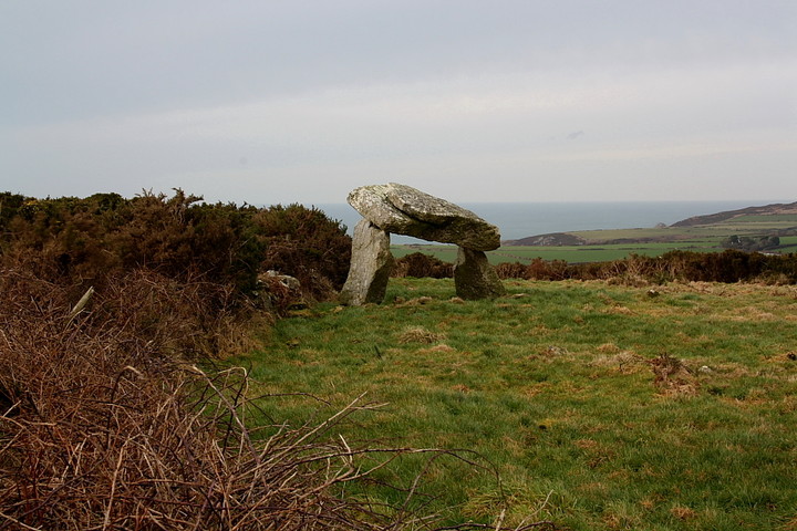
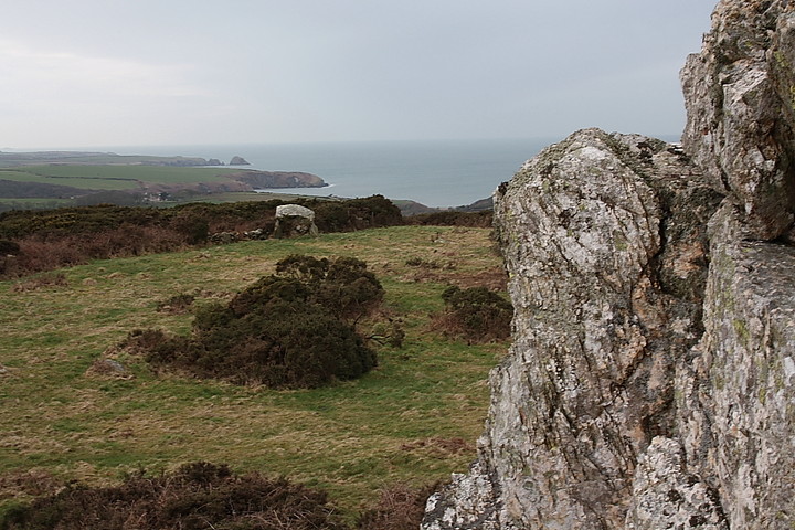
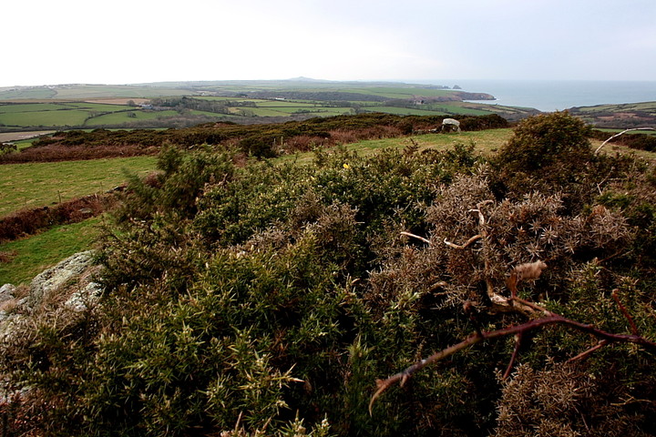
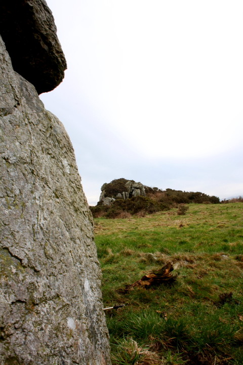
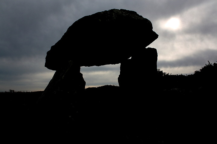
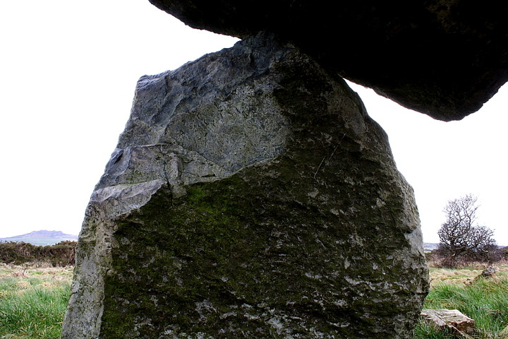
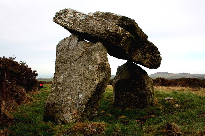
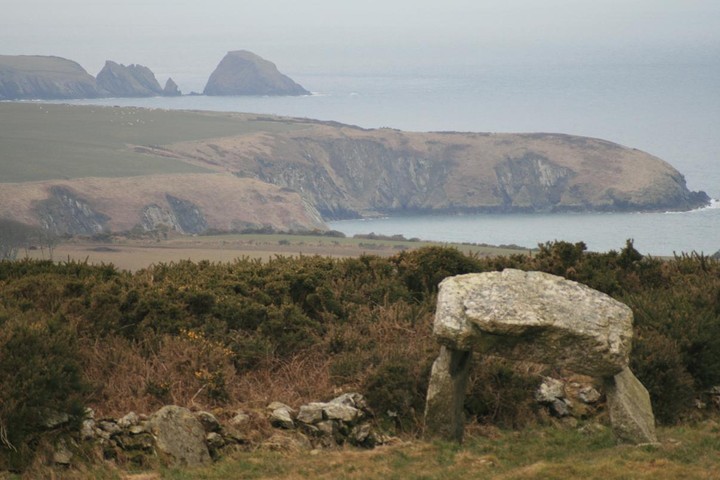
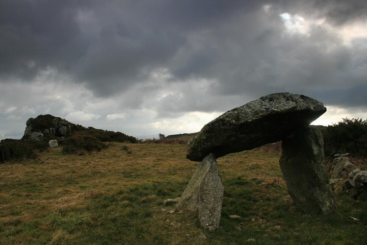
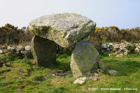
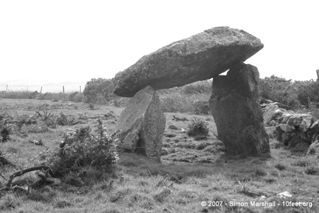
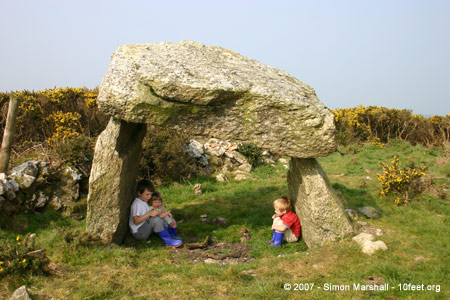
Ffyst Samson's intrigued me for a while now. Hard to define the reasons why... I guess it just looks so, well, ancient.. so 'hoary', an iconoclasm to this modern world of ours which demands that everything must be defined, must have its place, must be categorised. Sanitised with bleedin' antibacterial handwash before it can be touched. Ffyst Samson seems to say 'I think not. Come back in another thousand years and we'll talk!' Yeah, sure, we think we know what it was for. A tomb. But what ritual, what rites were carried out here? Ffyst Samson seems, to me, to represent everything we don't understand from the old times before we (apparently) learned to use our reason. So, low cloud over Y Preselau suggesting it would be unwise to wander once again upon bluestone territory, I decide to pay an overdue visit. As noted by others, even a relatively recent 1:25k OS map is of little use, save directing me to a parking space (opposite a very long farm shed) a little south of St Nicholas. A footpath sign points uphill and.... basically keep going, crossing barbed wire fences when encountered until the 'rocky outcrop' is seen in the field to your left. Cross yet another barbed wire fence to enter this field and there the fabulous cromlech is. Not that my approach was that direct, you understand.... wouldn't be fun otherwise. The first thing you notice about the monument is that, like a bumble bee, the capstone shouldn't really stay up at all.... that it manages to remain supported upon its two rough orthostats is an undeniable fact that seems to defy the very laws of physics themselves! The second is the rather obvious siting beside the rocky outcrop. Coincidence? Hmm. If I was a betting man.... The wind is absolutely biting cold, but there is no leaving here in a hurry. The Pembrokeshire coastline lies beyond, to the north, the hillfort of Garn Fawr prominent upon the horizon. Yeah, expansive views are there for the taking - sorry, that's the wrong word... for the 'accepting' - but the difficulty of location, let alone access, ensures the vibe here is one of private meditation. No doubt this was not the original intention, but hey. A further stone lies prostrate a little distance away, in all probability once part of the structure, but now taking it easy. Then there's the rocky outcrop. Needless to say one can't leave without a quick view from the top of the cromlech's natural companion, predecessor, even, although the export strength briars and gorse render the accomplishment of this somewhat uncomfortable, yet nevertheless essential. Structurally speaking, Ffyst Samson is a simple monument of a type the antiquarians of old (not the Modern Antiquarians, oh no!) would have called 'rude' and 'brutish'. Maybe. But I'll tell you something, there is nothing remotely straightforward about the effect it - and others like it - can have on a receptive human mind. The power of suggestion, no less. Perhaps the farmer is playing 'silly buggers' with regards access... or perhaps not? Whatever the case, in my opinion a visit here is worth the hassle. Not to mention a long drive. |
 Posted by GLADMAN
12th March 2011ce Edited 14th March 2011ce |
|
Visited 30.6.10. Follow Postman's directions - they worked for me! It is worth the effort to see the marvellous rocky outcrop alone. The chambered tomb is a little cracker - close to the outcrop - big enough to crouch under. It took me 15 minutes to walk up through the fields and I had to climb over two barbed wire fences to get to the site. But it was definitely worth it. The views are good but I am sure the rocky outcrop was what drew the ancients to this place originally. Well worth the effort but not the easiest place to find or access. There is a public footpath sign on the road near the farm but no obvious footpath thereafter. |
Posted by CARL 6th July 2010ce |
|
Definitive directions: There is room to park on the road to the west by a house, walk south back down the road to a footpath, a gate has to be climbed to get in the field and once there the path is indistinct. Go straight up the hill through a gateless gap in the hedge, the map says the path forks here but as there is no path on the ground, we must trust our noses, i'm Anosmic so which sense i'm using I dont know. Keep going uphill untill you see the big rock outcrop, a fence is crossed and there is the cromlech in the same field as the outcrop. It is only a ten minute walk to the stones, one or two gates and fences, put away any fear of farmers this is our world, "I was here first" is no excuse to keep us out, be brash, be brave and if caught out feign ignorance. Ffyst Samson is just brilliant, how could it possibly stay up there, my daughter and me tried to push it off to no avail, ( i'd be mortified and stay at home forever if we'd succeeded) I guess its just so damned heavy and we're so little. In the wall next to the cromlech is an out of place large stone and just yards to the north is a longer stone which could have been part of it. The outcrop is easy to climb even for a ten year old girl so no excuses, the view from the top is exquisite in the extreme, the cliffs and rocks by the sea, the other rocky tors nearby and further away the blunted peaks of the Presellis. Perfect, I suppose I should have said I never found it either to help presreve its solitude and mystery, but this kind of peace and beauty cant stay hidden forever, welcome to the wooooorld of tomorrow. |
 Posted by postman
14th March 2010ce Edited 14th March 2010ce |
|
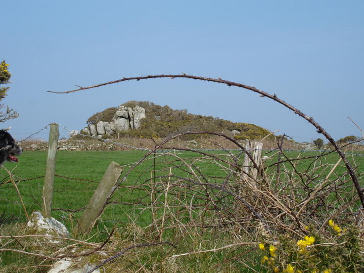
Visited 13/04/07: As Merrick says, this isn't an easy site to get to. Having looked at large scale maps since our visit I have a strong suspicion that one of the public footpaths that should pass close to the tomb is blocked by a fence. The tomb stands just to the south of a rocky outcrop that's clearly visible from the road (see Moss' photo) but not marked on the Landranger. It's in the corner of a field, with gorse obscuring the view of it from the south. We found our way to Ffyst Samson with some difficulty. We tried working from Merrick's directions, approaching from the south, but I wish I'd taken a better map with me. We ended up loosing the footpath, which I wasn't really comfortable about, but it really wasn't clear where it went. If I did it again I'd try an alternative route, approaching from the north east. |
 Posted by Kammer
9th June 2007ce Edited 9th June 2007ce |
|
A tad difficult to find if you've only got the map. The footpath marked is not marked or obvious on the ground. There's a footpath sign a few hundred metres further north along the road by the houses, but it points straight into a 6ft wall! The presence of the furious gorse that grows all over so many of the cromleched outcrops was off-putting, but we persevered and it paid off. It stands with the capstone on two remaining uprights, with such squared angles involved that it looks for all the world like a mini-Stonehenge. As with so many cromlechs in the area, the capstone is a fat-spearhead like D-shape. The possibly tooled flat end faces the pillar outcrop. There are clear views to the same three peaks of Mynydd Preseli visible from most monuments hereabouts, to all the northern outcrops of the Pen Caer/ Strumble Head peninsula, Carn Gelli (the outcrop above Ffynnon Druidion), and a clear sightline to Carreg Samson cromlech and the peaks around Pen Caer Dewi/ St David's Head. Glad to see that somebody's been deliberately clearing the cromlech of gorse. Directions: From the road at the western side, head up the hill towards the rocky outcrop. Once above it, you see a dramatic towering pillar of outcrop beyond – head towards this. The cromlech is in the same fence boundary as it, 60metres below, SW toward the houses. visited 22 Aug 04 |
Posted by Merrick 7th September 2004ce |
Miscellaneous |
|
|
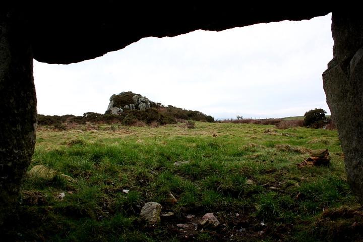
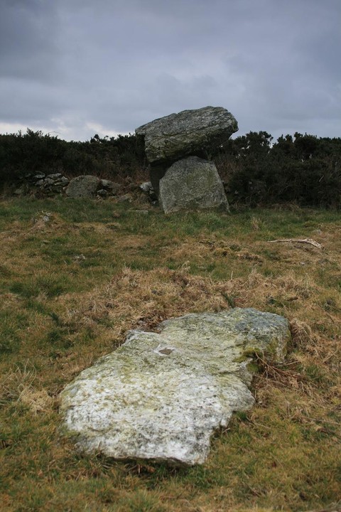
As you can be see, I didn't find the cromlech, it is apparently but a few metres east of the rocky tor/outcrop on above photo which obviously gives the cromlech its significance according to Neolithic Sites of Pembs., Children & Nash). To get nearer the outcrop would have involved pushing through three lots of barbed wire plus climbing stone banks - something the Welsh farmers really get cross about! Given its narrative within the landscape, (some cromlechs are hidden from view) this one, according to Children, its importance is linked with the rocky outcrop. It was not a visual concept, such as Carreg Samson maybe, but one constructed through ritual and symbolic knowledge of the landscape. My interpretation of what he means by this, is that the shape of the outcrop is similar to the shape of a burial mound. Similar tor like shapes are found on the Preseli mountains - natural places being seen as the burial stones of long dead ancestors. |
 Posted by moss
25th April 2007ce Edited 9th June 2007ce |
In the book Saints and Stones (ISBN 1-84323-124-7) Davies and Eastham describe Ffyst Samson as a landmark on one of the Medieval pilgrim route to St David's:A walk from Trellys-draw farm leads through a gate up the hillside footpath opposite for 0.5ml to the moorland beyond. The tomb stands among gorse on a rocky plateau commanding stupendous vistas over the surrounding countryside towards St David's Head and the sea. The enormous, rugged capstone rests delicately on two metre-high sidestones.According to Davies and Eastham the name 'Ffyst Samson' translates into English as 'St Samson's Flail' (the inclusion of the title 'Saint' indicates a degree of bias towards Celtic Christian tradition). |
Posted by Kammer 10th June 2004ce Edited 25th June 2004ce |