Mystery mine of Ivinghoe where ancient Britons worked flints. Amazing finds.
For 3,000 years travellers on the ancient Icknield Way threw anything they did not want into an old flint mine by the roadside. Long centuries of rubbish gradually filled it up, the top caved in, and eventually all trace of the mine was lost. Recent work in laying a waterpipe has revealed this storehouse of the centuries, and the discoveries made there bid fair to cause acute controversy amongst archaeologists.
Sheltered beneath the bluff face of Ivinghoe Beacon - the gaunt spur of the Chilterns overlooking the vale of Aylesbury - runs the ancient Icknield Way, and into its stones is knit the history of Southern England. Today a reporter followed again the road which once resounded to the martial tramp of Roman legions. Since the dawn of Britain's history travellers have stopped at this point. Today they still do so, and but a stone's throw away is the old mine.
To Mr W. Cobell, the one-armed garage man, these remarkable discoveries are due. Badly wounded in the War, an open-air job was necessary to keep him fit, and he now contrives to combine making a living with his hobby of archaeology. Mr Cobell led the way to the old shaft, half-hidden between a hawthorn hedge. Forty feet down into the solid chalk this old mine sinks into what was once a rich seam of fine flints. Four feet across, it is just wide enough for a man to straddle his legs. That revealed how the ancient miners ascended and descended probably 3,000 years ago. A series of footholds had been cut on either side of the shaft, and today young Sam, the enthusiastic excavator and purveyor, clambered down in the same old way, disdaining the modern rope and tackle. With an electric torch he illuminated its gloomy depths - the bottom is not yet reached - and showed where another tunnel leads away into the heart of the hill.
At the bottom of the shaft a magnificent flint axe with a giant left-handed grip has been found. There were also other rude weapons and arrow heads of flint, flakes and chippings, spear points, bones of animals, and similar traces of the ancient British village which once occupied the site. "These were the people who dug the mine and worked it until the flints ran out," Mr Cobell said. "Then it was just left open and became the rubbish pit for anyone passing by on the road." Above the prehistoric debris came traces of the Roman occupation of Britain. A roof tile of unmistakeable Roman make and a chimney tile bear the footprints of a dog that walked over them while they were wet and drying in the sun. Its footmarks can still be seen. A bronze coin of the Roman period has also been found, but its exact date has yet to be determined. Vast quantities of pottery of the early Iron Age were mixed in indescribable confusion with Roman wares, Anglo-Saxon wares, and pottery of successive peoples down to the fine medieval glazes. Fragments of 16th and 17th century glazes lying on top of all this accumulation have definitely been identified.
A few yards away is another curious hole made by these prehistoric miners. It may have been the floor where the flints were worked. The tremendous number of flakes found suggest that it was, but it was also the scene of a great fire, for which there is no explanation at present. Charred bones, burnt wood, and scores of flints scorched and split by intense heat are still there. Mr Edward Holis, curator of the Buckinghamshire County Museum at Aylesbury, said: "I know of nothing in England like this mine, if mine it be. The variety of the debris from so many periods of history is amazing, and until the site has been fully examined by experts it is impossible to say what is the real solution." In the 'Gloucester Citizen', 25th August 1932.
|

|
I'm glad HornbyPorky's fieldnotes say the graffiti is gone. I thought I'd add this to show the indignities have been going on for a while. I hope when McDonalds crumbles these stones will still be here.
On Saturday, the Greater Edinburgh Club, under the leadership of Mr Sterling Craig, visited "Edinburgh's Stonehenge," a group of four large stones at Lochend, opposite the point where the new Glasgow road branches off the old road to Broxburn. For 4000 years these megaliths have stood like the peak of a submerged mountain rising out of the ocean of prehistoric darkness, but testifying to the existence of a lost continent.
Local tradition says that there was originally an avenue of standing stones, 350 yards long, crossed by a shorter double row of megaliths about 80 yards from its western end. A Bronze Age burial ground, 30 yards in diameter, of much later date, has been erected in the northern part of the crossing. The eastmost megalith is eleven feet high and three to four feet broad, and the others are about six feet in height, standing at the souther, western, and northern extremities of the crossing avenues.
The unity of the monument is now difficult to recognise, because it is broken by a deep railway cutting and a wide road. The terminal megalith (now in a piggery) is obscured from the rest by a large advertisement hoarding, but it undoubtedly belongs to the same period as Stonehenge and was erected by the same fogotten race.
In The Scotsman, 23rd May 1938.
|
Besides the loch itself there are several tarns, one of which rejoices in the name, Lochan Ora, "the golden lochlet." Here, unless tradition is false, lies a bull's hide, with many golden pieces, dropped into the tarn when the enemy pressed too closely.
Beyond a doubt that mound we pass by on the right shore of Loch Builg marks the grave of two Highlanders, who made their final halt here in the retreat from Culloden. In 'A Highland Tramp' by Alex Inkson McConnochie, in the Leeds Mercury, 21st May 1907.
I surely can't help thinking of people symbolically depositing valuable articles in water in prehistory. I spotted Kelly Gillikin Schoueri's thesis all about the topic in Scotland. Sounds like a mini loch next to your own loch with crannog might be the perfect (liminal yet handily domestic) spot. Just speculating :) It'd be pretty crazy if folklore had handed down such a tale.
|
... Arbour Farm was next reached, and here, by the kind permission of Mr Meadows and Mr Bourne, the club visited the ancient Celtic stones known as the "Devil's Ring and Finger." There are two very large stones, one, an upright stone, grooved longitudinally, and with lateral grooves, where, possibly, arrow heads and pike heads may at some time have been sharpened, and shaped like a huge finger, represents the finger of his Satanic Majesty; and a broad flat stone, with a hole almost circular in the middle, is the ring. The stones belong probably to prehistoric times.
A local story, however, is to the effect that the stones arrived mysteriously one night after a girl had been murdered at the spot. ... From a report of the N.S. Field Club, in the Newcastle Guardian, 22nd August 1908.
|
As regards the stone at Inverfolla, which is a very big one, and which has long been prone, there was an old local tradition that if anybody interfered with the stone or moved it, he would die within the year; and it is said that one man long ago did attempt to do this, and that he actually did die within the year: since when the stone has been quite safe, and has had a remarkably quiet existence, as nobody would now interfere with it for wealth untold.
I am, etc. Alex K. Stewart Lt-Col., of Achnacone. In the Oban Times, 2nd June 1923.
Canmore's record seems to confirm that the stone is still lying un-messed-with, and indeed is very large at 3.8m long and 0.7m breadth at its base (but a fairly skinny c. 0.13m thick).
|
One of the seven wonders of Glamorgan is the tumulus near the Bodvoc Stone on Margam Mountain. It is called the "Twmpath Diwlith" - the dewless mound. Tradition tells us that no dew ever falls on this mound. In the 'Glamorgan Gazette', 5th September 1924.
also (warning, does get a bit bitchy):Folklore of the District. (By Martin Phillips.)
Camden, in his "Britannia" (1610) remarks: 'In the very top of an hill called Mynyd Margan, there is erected of exceeding hard grit, a monument or gravestone, four foot long, and one foot broad with an inscription, which whosoever shall happen to read, the ignorant common people dwelling there about, give it out upon a credulous error, that he shall be sure to die within a little while after. Let the reader therefore look to himself, if any dare read it, for, let him assure himself that he shall for certain die after it.'
Writing in 1722, Daniel Defoe ('Tour through England and Wales') makes the following comment: 'In this neighbourhood, near Mynydd Margam, we saw the famous monument mentioned by Mr Camden, on a hill, with the inscription which the people are so terrified at, that nobody will care to read it; for they have a tradition from father to son, that whoever ventures to read it, will die within a month. We did not scruple the adventure at all, but when we came to try, the letters were so defaced by time, that we were effectually secured from the danger, the inscription not being anything near so legible as it seems it was in Camden's time.'
The inscription is still perfectly legible, and presumably the mountain climb did not appeal to Defoe who frequently expressed his abhorrence of Welsh antiquities and Welsh mountains, and apparently, he had no desire to risk the deciphering of the 'terrifying' inscription. Incidentally he has been described by a recent writer as 'one of the world's greatest liars, with a peculiar art for making fictitious narrative sound like the truth'. Defoe's description of other Welsh antiquities confirms the statement.
The Bodvoc stone was believed to cover buried treasure, and about sixty years ago a wide hole about five feet deep was dug around it at night. The stone was overthrown, and for a long period was covered with water. It was subsequently set up in an upright position, and the erection of an iron railing protected it from further harm. Guarding the alleged treasure was the inevitable ghost, which was said to be that of the departed Bodvoc.
Near the stone is the huge mound known as 'Y Twmpath Diwllith' (the Dewless Mound), which was erroneously considered to be always immune from dew. The word 'Diwllith' became translated to 'Dewless', but apparently it is a corruption of "Duw-lith" (God's Lesson). The mound is situated on the boundary line between Llangynvyd and Margam parishes, and in former times, during the yearly perambulation of the boundary, the customary lesson was read by the priest when the mound was reached. In the 'Neath Guardian', 28th April 1933.
|
A single Druidical stone is visible in front of the farm house of Sannox, in the middle of the green field. Many remains of a similar kind are still extant in the mosses and glens of the island. Of late much has been done to solve the enigma of those monoliths.
A pretty tradition has been handed down of a daughter of Fingal going out to meet her lover in the woods, having disguised herself by dressing in man's clothes; her lover, deceived by the circumstance, espied her amid the thick wooding, and, supposing her a foe, took his bow and drew an arrow from his quiver, and unfortunately killed his love. On the ground where she fell, he raised the tall monolith to commemorate the sad event, and had a second placed for himself not far from it - committing self-immolation. Her remains were buried entire, but his received all a chieftain's honours and druidical rites, placed in an urn, inside a stone chest, alongside of his love.
Such is the tradition as handed down. There is still a love of the superstitious and the marvellous amongst the islanders. Yet, strange it is, in the very centre and civilization here are as great attempts to revive that ancient spirit of magic, hence those seances and impositions. There seems little doubt now regarding one use of those stones, that they were raised to mark the last resting place of the ashes of the great. This seems quite established. In the Ardrossan and Saltcoats Herald, 9th August 1862.
|
The "Stannin Stane" on the Hill of Kirriemuir is, undoubtedly, the most familiar object among our local antiquities. Many who have never seen i t know it through Barrie's writings; but every Kirriemuir boy has bestrode it, and visitors to the Hill rarely fail to give it some attention.
Formed of the old red sandstone of its site, the great, solitary monolith measures 9 feet in height, is 7 feet in width at its broadest part, and averages a couple of feet in thickness. There is no exact record regarding its hold on mother earth, which, probably, is not great, for the native rock crops out all round.
But there are tales, difficult to credit, of its being originally "as high again" as it is now; of its standing on another stone even larger than itself; and of its having split in two, overwhelming a band of robbers who were dividing their ill gotten plunder at its base.
No record appears on its surface; no tradition exists to explain its origin or purpose; surmise alone can offer any feasible explanation of its meaning. Says one, it marks the bounds of some ancient tribal possession; says another, some great warrior of old lies buried here. But, whatever its precise age or origin, it may safely be affirmed that the "Stannin Stane" saw all the conflicts waged between the early Picts and Caledonians, and marked the advance of Rome eastwards to the sea, from the great camps of Ardoch and Cardean to Stonehaven, Aberdeen, or the Moray Firth, or from Battledykes by Forfar to the Tay. In the 'Forfar Herald' of 23rd October 1908.
|
In a small field near the confluence of the Burn of Kilry with the River Isla is a huge monolith known as the Standing Stone. It is about seven feet above the ground and ten feet in circumference at its base, tapering slightly to the top. While making agricultural improvements many years ago an attempt was made to remove it, but it was found to be so deeply embedded in the ground that the effort had to be abandoned.
That this monolith was raised to commemorate some great event, or fulfil some important purpose, there can be little doubt, but why it was raised or what people raised it are unknown. In all probability it was set up by the Druids, the high priest of whom performed his sacred rites and dispensed justice at the pillar. It is also said to mark the site of a battle between local rival families, when many of the combatants were drowned in the swollen river. Any such tale is unworthy of credence. Almost without doubt the stone stood where it is long before these families were ever heard of. In the 'Kirriemuir Free Press' of 16th June 1955.
|

|
The Boy Who Was Taken By The Fairies Of Knockfierna.
Elm Park is a townland situated in the County Limerick, about five miles to the west of the city. About fifty years ago there was an old man and his wife living in a farmyard in this place. One night, about eleven o'clock, the old man heard someone moving about in the yard. He opened the door and saw, standing about ten yards from the door, a little boy about twelve years of age. He called him in and asked him who he was. He could get no answer from the child, who appeared to be in a dazed condition. They kept him throughout the night, and in the morning the man sent for the priest. The latter came and prayed over the child.
When the prayers were finished, the child seemed to regain the use of his faculties and he told the priest his name, and said he was from Knockfierna. He further stated that at about 7 o'clock on the previous evening he was looking for the ass about two miles from his home. As he approached the "lios" a horseman came forth from it, snatched up the boy, placed him in front of him and galloped off. The boy remembered nothing until he found himself at the place mentioned above.
The priest communicated with the parents of the child, and on the following day he was taken home, much to the relief of his people, who had spent the previous night searching for him. The belief was that he was taken by one of the fairy huntsmen of Knockfierna.
W. J. Carey. Munster News, 11th October 1930.
|
As to the searching beneath ancient monuments for treasure there was a story that years ago when search was made near the large stone just above Catchall for a crock of gold, the stone groaned fearfully and the pit was filled with blood. Mentioned at the annual meeting of the Penzance Natural History and Antiquarian Society in 1881, and reported in the Cornish Telegraph (17th November).
|
  
|

|
Sir Richard Colt Hoare's account of the barrow, with super cross-section illustrations and one of the entrance, published in Archaeologia volume 19 (1821).
|
A photo of the stone, rather weirdly sitting in its concrete plinth in the grounds of Cwrt Sart comprehensive school.
|
My grandfather James Carroll who lives in Spa Boyle told me the following story about the Druids altar. There is a Druids altar in Tinnecara to the north side of the railway in Thomas Ballintinels land. The altar is made of three large stones two uprights and one over head. Each stone weighs about ten tons weight. The druids used to come home from Knockadoo and swim across Lough Gara to worship their god at this altar. Recorded as part of the Schools Collection in the 1930s, and online now at Duchas.ie.
|
Photos of the weird and lovely 'grape cups' (aka incense cups) found in the region.
|
There is another stone circle on "Brewel Hill" known as "The Piper's Stones.
The tradition about these stones is A lot of maidens were tempted to dance on an holy day, while a piper played for them. Like a flash of lightening they were all changed into stones. Collected as part of the Schools Collection in the 1930s, and now online at Duchas.ie.
|
There is a standing stone in Cryhelp about three miles west of Dunlavin. It has a hole in the top of it about nine inches long and four inches wide. There is an old tradition about it, that it was not aways in that place, it was moved to mark the grave of Harold, chief prince who was killed in the battle of Glen Mama.
The corner of the field in which the Cryhelp stone is standing is said to have been a cemetery a long time ago, covered with trees. Near at hand is a nettle-covered hollow, which was at one time opened; there is an underground passage leading to a mound not far away. It is not said that this hole was used to cure anything. Recorded as part of the Schools Collection in the 1930s, and now online at Duchas.ie.
|
Historical Ordnance Survey NI maps with stones and so on marked, courtesy of the Public Record Office of Northern Ireland.
|
This image by Niamh Ronane has sheep for scale.
|
This rock is probably over 300 tons in weight and is in a field beside Killenduff National School. It is split in two as if it were hewn by a saw. This is the tradition connected with it:-
Ages ago two fierce giants lived on the Ox Mountains. They argued about their respective strengths and what they could do. They agreed to put the argument to a test by throwning a stone. They selected two large stones of similar size, several tons in weight. The idea was to see who could throw the stone from the Ox Mountains to the sea, five miles distant.
The first took up the stone, flung it, and it fell into the sea. The second took his throw and it fell about half a mile from the sea in its present position. The second giant's rage was so great seeing that he had failed in his attempt that he seized his sword, ran towards the rock and with one fierce cut, split it in two. Collected from Peg Judge in Croagh, and recorded in the Schools Collection of the 1930s (view at Duchas.ie.
Also in the Collection:The tradition says that any body who walks through the Rock three times shall surely meet their doom. I have never heard of any body to go through it three times. The DromoreWest website suggests your doom might come a bit quickly, as the rock will slam shut on you.
|
Tales from English Folklore.
The folktale from the stones enacted (followed by Ronald Hutton).
|
The floor of the chamber is covered with a deposit of mud. The tomb is locally considered to be a holy well and offerings of coins, some quite recent, medals, broken glass, etc., lie on the lower roofstone. The interior of the chamber is littered with broken glass. From p128 in 'Survey of the Megalithic Tombs of Ireland, vol 1 - County Clare' by Ruaidhri de Valera and Sean O Nuallain (1961).
In an article called 'A Folklore Survey of County Clare' in Folklore v22, 1911, it says, "The mud of the dolmen or "well" of Tobergrania at Ballycroum cured sore or short-sighted eyes."
|
Source of sarsen stones pinpointed
David Nash and his team of researchers believe the sarsens come from West Woods, south west of Marlborough, and 25km from the circle. They've geochemically matched the site using a chip from Stonehenge that was taken during a restoration project in the 1950s. Two of the fifty remaining stones at Stonehenge don't match the West Woods site though...
Article on today's Guardian website.
The research paper can be read here in Science Advances.
|
The Rollright Stones and their Folklore, by Arthur J Evans. From Folklore v6, 1895.
More folklore and etymological speculation about the stones than anyone can handle.
|

|
Witts, in his 'Archaeological Handbook of the County of Gloucester' (1883) says:It is 100 feet long, its greatest width being 50 feet, and height five feet; its direction is east and west, the highest portion being towards the east.
The mound was cut in two about fifty years ago to make room for a cottage and some pigstyes; the latter now occupy the centre of the barrow! During the excavation one human skeleton was found. Probably this is the only instance in the county of a prehistoric burial place being turned into a pigstye!
|
A little pottery vessel found at the east end of the barrow. It's only about 10cm across. Check out the variety of impressions made to decorate it.
|

|
The lovely flat shale bead found in the long barrow at Eyford. I love a nice shale bead. Imagine how nice it would feel in your hand.
|
|
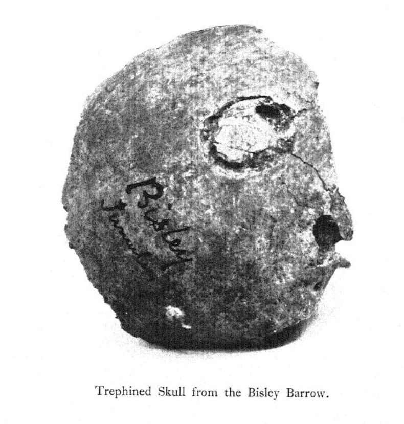
Not really tea-time viewing, but I've posted a photo of an apparently 'trephinated' skull found in a long barrow at Bisley (perhaps this very barrow... it's a bit confusing). It was found by Dr. W. H. Paine from Stroud, in 1863. We read: "this is only a partial trephination, the operation having been abandoned either on account of the death of the patient or an unwillingness on the part of the priest-doctor to proceed with it." How about the unwillingness of the patient?! This 1923 paper by Thomas Parry even has some photos showing his (patientless) experiments into how it might have been done. A fascinating and ghastly subject to ponder on.
|

|
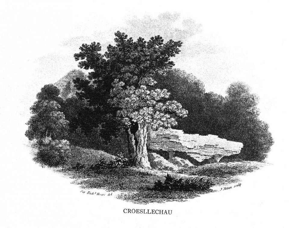
In a field called Croeslechau about two miles eastward of this town or village [Talgarth] but in the parish of Bronllys and on a farm called Bryn-y-groes, is a cromlech, not merely interesting on account of its antiquity, but from the circumstance of a white thorn growing close, and indeed under part of it, which has gradually raised the horizontal or covering-stone several inches out of its original position; it is therefore not only venerable as a relic of very ancient days but as a natural curiosity. Theophilus Jones, History of the County of Brecknock, v2, 1809.
The RCAHMW's 1986 inventory of ancient monuments in Brecknock puts the site 500m south west of Pontithel, and includes a description by Edward Lhuyd from about 1700.
In Ireland surely a barrow with a strange hawthorn (white thorn) would have been given a wider berth... an indication that the fairies were living there and wouldn't be happy about any disturbance. But maybe things don't work that way in Wales. The barrow was destroyed in the first part of the 19th century and it's not very obvious where it was.
|

|
On the lower declivity of Warton Crag, in the parish of Warton (which abuts on Morecambe Bay and the Westmorland border), commanding a beautiful and extended prospect of the bay, a seat called "The Bride's Chair" was resorted to on the day of marriage by the brides of the village; and in this seat they were enthroned with due solemnity by their friends; but the origin and the object of the custom, which has now fallen in disuse, are unknown.
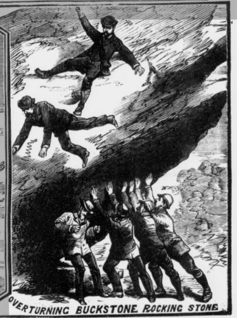
Not far from Warton Crag are three rocking-stones placed in a line, about forty feet asunder, the largest stone lying in the middle.
A cave is also mentioned by Lucas, named "The Fairy Hole", where dwarf spirits called Elves or Fairies, were wont to resort. Lancashire Folk-lore: Illustrative of the Superstitious Beliefs and Practices, local customs and usages of the people of the county Palatine. By John Harland and TT Wilkinson, 1867. Online at the Internet Archive.
|
Scanned version of Sir Richard Colt Hoare's "Ancient History of South Wiltshire" (The Ancient History of Wiltshire volume 1). What a classic! He dug into a lot of barrows (you can hear his enthusiasm. But at least he notes what he found).
|

|

|
 
|
  
|

|
It is traditionally supposed that beneath the surface of this camp vast stores of gold and silver are hid in an iron castle, the door of which is guarded by spirits and can only be found at the full moon.
It is stated that many years ago some labourers dug there with the hope of finding the treasure, but were obliged to desist because of the mournful sounds they heard, caused no doubt, by the howling of the wind among the trees.
A story is also told of a Dr Farrer, who lived in the parish and was learned in books and who found out from them how to get into the castle. The day before the full moon he went over the field with a hazel rod, and when he came over the door, the stick stood upright in the ground. The doctor returned at night with his servant and tools for digging and also took his bible with him. He set his servant to work, giving him particular instruction that whatever he saw or heard he was not to utter a word for his life.
The man went on digging, and at last his spade struck on the iron door of the castle, when horrible groans and cries were heard, and spirits began to come out of the door. The man was so frightened that he forgot his master's instructions, and cried out "Lord, have mercy on my soul," when one of the spirits caught him by the leg and would have carried him off, but the doctor put the bible on his head and dragged him out with the other hand.
The pit was closed up, the door banged together, and its position was changed so that no one has been able to find it since.
ETNE. In the Taunton Courier, 12th April 1958. It rather served him right, expecting his servant to do all the dangerous work. I have a vision a bit like 'Raiders of the Lost Ark'. Also, the castle being made of iron rather discounts the involvement of the fairies in this case.
There is a story told locally of two men, who, many years ago, lived on the Quantock Hills. One day, finding themselves in financial difficulty and not knowing where to obtain any money, they decided to go over to Ruborough Camp, Broomfield, to try to discover some of the money and treasure supposed to have been buried there. As soon as it was night-time they left their homes and with picks and shovels on their backs, proceeded on their way. As they entered the tree-covered lane leading to the camp, they walked with caution in case they disturbed the stags and foxes resting there, but all was well and at last they reached the Camp.
It was a clear moonlit night and no doubt they could see the old castle at Enmore and further away the town of Bridgwater. They found the mound of earth where money and treasure were supposed to have been buried and after removing their coats, started to dig. Suddenly the ground gave away from beneath them and they disappeared.
After some hours had elapsed their relatives at home became alarmed at their not returning and decided to go to look for them. On reaching the old Camp they discovered to their amazement two coats beside a very large hole, but there was no sign of the two men. Being superstitious people they hastily returned to their homes saying that the pixies had captured the two men, who were never seen again.
This story may not be true, but it was told to me by old people living in the district years ago.
A.H., BRIDGWATER. In the Taunton Courier, 29th March 1958.
These stories seem pretty similar to the ones written down with even more elaboration by the Rev. J W Collins in 1857.
|
This hill, it has a meaning that is very important for me, but it's not rational. It's beautiful, but when you look, there's nothing there. But I'd be a fool if I didn't listen to it.
-- Alan Garner.
...I'd rather be
A Pagan suckled in a creed outworn;
So might I, standing on this pleasant lea,
Have glimpses that would make me less forlorn...
-- William Wordsworth.
Some interesting websites with landscape and fairy folklore:
http://earthworks-m.blogspot.co.uk
http://faeryfolklorist.blogspot.co.uk
|
|