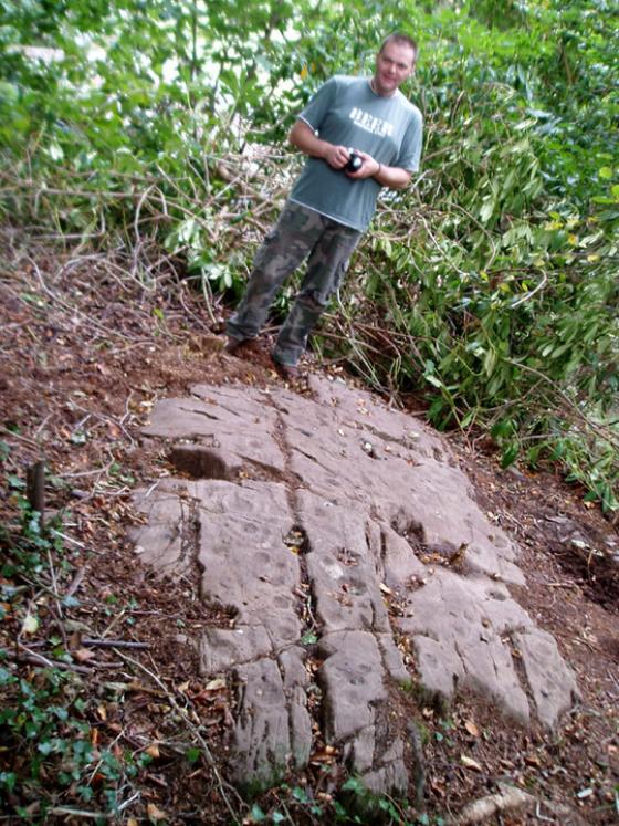
The Modern Antiquarian
Log in
|
Register
Home
Latest Posts
Forums
Maps
Help
Browse Sites
News
Blog
Contributors
The Books
Select
-
Belgium
Denmark
Eire
France
Germany
Greece
Italy
The Netherlands
Norway
Portugal
Republic of Malta
Spain
Sweden
Switzerland
United Kingdom
Scotland
Dumfries and Galloway
Barholm
Barholm 3
Cup Marked Stone
Barholm 3 (Cup Marked Stone) on The Modern Antiquarian, the UK & Ireland's most popular megalithic community website. 1 image, 1 weblink, plus information on many more ancient sites nearby and across the UK & Ireland.
Image © © Brian Kerr 2007
Nearest Town:
Gatehouse Of Fleet (8km ENE)
OS Ref (GB):
NX526541 /
Sheet: 83
Latitude:
54° 51' 35.05" N
Longitude:
4° 17' 48.06" W
Added by
rockartwolf
Images (1)
Links (1)
0 discussions
Start a topic
Show |
Hide
Web searches for Barholm 3
Flickr
Google
Google Images
MAGIC
The Megalithic Portal
Bing
Stone Pages
Streetmap.co.uk
Wikipedia
Show map
(inline Google Map)
- Sites within 20 km -
-
Cairnholy Cairn (0.62km W) (5 posts)
Cairnholy 03 (0.63km W) (0 posts)
Bardristane 4 (0.67km SE) (6 posts)
Bardristane 1 (0.71km SSE) (5 posts)
Bardristane 3 (0.72km ESE) (3 posts)
Cairnholy (0.82km WSW) (138 posts)
Cairnholy 01 & 02 (0.82km WSW) (8 posts)
Cairnholy 09 (1.07km W) (5 posts)
Cairnholy 04 (1.11km W) (1 post)
Cairnholy 06 (1.14km WNW) (1 post)
Cairnholy 08 (1.16km W) (1 post)
Cairnholy 10 (1.16km WNW) (0 posts)
Kirkmuir 3 (1.2km WSW) (1 post)
Kirkmuir 1a & 1b (1.2km WSW) (1 post)
Kirkmuir 2 (1.2km WSW) (1 post)
Barholm 2 (1.21km SSW) (1 post)
Cairnholy 05 (1.22km W) (2 posts)
Cairnholy 07 (1.28km WNW) (0 posts)
Kirkmuir 4 (1.3km W) (1 post)
Barholm 1 (1.36km SW) (1 post)
Kirkdale House (1.36km SW) (2 posts)
Kirkmuir (1.4km WSW) (3 posts)
Kirkdale Mains Stone (1.43km WSW) (1 post)
High Auchenlarie (1.47km E) (8 posts)
High Auchenlarie (1.51km E) (20 posts)
Kirkclaugh (1.77km SE) (1 post)
Kirkclaugh (2.02km ESE) (2 posts)
Claughreid (2.1km NW) (12 posts)
Cairnharrow (2.12km NNE) (11 posts)
Laggan Farm (2.27km E) (3 posts)
Upper Newton 4 (2.77km ENE) (0 posts)
Doon of Carsluith (2.82km W) (8 posts)
Upper Newton 1 (2.86km ENE) (4 posts)
Newton Farm Burial Chamber (2.96km E) (12 posts)
Cauldside Burn Cairn (3.01km N) (8 posts)
Cauldside Burn (3.01km N) (12 posts)
Newton Farm (3.03km E) (1 post)
Cairnharrow (3.04km NNE) (18 posts)
Newton Farm (3.07km E) (3 posts)
Cauldside Burn Stone Setting (3.12km N) (4 posts)
Cauldside Burn Cairn North (3.16km N) (4 posts)
Blackmyre Moor (3.18km WNW) (5 posts)
Upper Newton 3 (3.26km ENE) (4 posts)
Mossyard 1 (3.29km ESE) (9 posts)
Mossyard (3.29km ESE) (21 posts)
Upper Newton 2 (3.3km ENE) (5 posts)
Cambret Moor (3.3km N) (12 posts)
Cambret Moor (3.35km N) (12 posts)
Mossyard 6 (3.4km ESE) (7 posts)
Lagganmullan 5 (3.44km ENE) (2 posts)
Bagbie Stone (3.49km W) (8 posts)
Lagganmullan 7c (3.5km ENE) (2 posts)
Lagganmullan 7a (3.5km ENE) (5 posts)
Lagganmullan 7 (3.5km ENE) (2 posts)
Lagganmullan 7b (3.5km ENE) (3 posts)
Lagganmullan 6 (3.5km ENE) (0 posts)
Lagganmullan 7d (3.5km ENE) (5 posts)
Bagbie Wall Stone (3.59km WNW) (7 posts)
Bagbie Four Poster (3.61km WNW) (10 posts)
Bagbie Cairn (3.61km WNW) (15 posts)
Lagganmullan 4 (3.66km ENE) (13 posts)
Lagganmullan 3 (3.69km ENE) (4 posts)
Whiteside (3.77km NE) (3 posts)
Lagganmullan 2 (3.85km ENE) (6 posts)
Lagganmullan 9 (3.99km ENE) (6 posts)
Lagganmullan 10 (3.99km ENE) (3 posts)
Lagganmullan 8 (3.99km ENE) (11 posts)
Lagganmullan 1 (4.04km ENE) (0 posts)
Lagganmullan House (4.07km ENE) (3 posts)
Blackmyre Farm (4.09km WNW) (2 posts)
Glenquicken Cist (4.47km NW) (13 posts)
Glenquicken (4.52km NW) (52 posts)
Glenquicken Moor (4.6km NW) (6 posts)
Kirkmabreck (4.68km W) (14 posts)
Rutherford's Witnesses (4.82km ENE) (6 posts)
Rutherford's Well (6.15km ENE) (7 posts)
White Cairn, Chapelton (6.52km WNW) (4 posts)
Trusty's Hill (6.55km ENE) (13 posts)
Penkiln (7.53km SW) (32 posts)
Harper's Hill (7.76km ENE) (10 posts)
Culscadden (7.83km SW) (8 posts)
Cairn of Knockglass (8.8km WNW) (11 posts)
Castle Haven (8.89km ESE) (6 posts)
North Balfern HillFort (9.39km WSW) (2 posts)
Tongue Croft (9.55km E) (18 posts)
North Balfern (9.67km WSW) (6 posts)
Bladnoch (10.26km WSW) (10 posts)
Broughton Mains (10.86km SW) (21 posts)
Auchenhay (11.21km E) (2 posts)
Cairnsmore of Fleet (11.39km NNW) (16 posts)
Knee of Cairnsmore (11.4km NNW) (9 posts)
Claunch (11.49km WSW) (15 posts)
Cairnhouse E (11.53km W) (5 posts)
Cairnhouse W (12km W) (7 posts)
Borgue (12.39km E) (6 posts)
Culnoag (13.02km WSW) (7 posts)
Arden Fort (13.22km ENE) (7 posts)
Ingle Stone (13.35km E) (4 posts)
The Doon (Twynholm) (13.38km ENE) (7 posts)
Redbrae (13.46km W) (3 posts)
High Nunton (13.49km E) (5 posts)
High Baltersan (13.53km W) (10 posts)
Clauchendolly (13.54km E) (54 posts)
Glengap House (13.55km ENE) (1 post)
Senwick 1 (14.14km E) (5 posts)
Billy Marshall's Cave (14.15km NW) (8 posts)
Brighouse Standing Stone (14.18km E) (6 posts)
Senwick 4 (14.19km E) (8 posts)
Clash (14.24km E) (11 posts)
Cunningham (14.26km W) (5 posts)
Gallows Outon 1 (14.28km SW) (4 posts)
Gallows Outon 2 (14.34km SSW) (4 posts)
Torhousekie Stone Row (14.43km W) (22 posts)
Torhousekie (14.43km W) (81 posts)
Torhousekie (14.89km W) (8 posts)
Torhousekie Farm (14.89km W) (10 posts)
Lessons (15.17km WNW) (10 posts)
Kirroughtree House E (15.19km WNW) (5 posts)
Kirroughtree House W (15.27km WNW) (6 posts)
Kirroughtree House (15.32km WNW) (1 post)
Kirroughtree House N (15.43km WNW) (5 posts)
Little Balsmith (15.44km SSW) (5 posts)
Culgarie (15.55km WSW) (12 posts)
Newton Stewart Cairn (15.8km WNW) (4 posts)
Hole Stone (16.02km W) (13 posts)
White Cairn, Crouse (16.05km W) (6 posts)
Whithorn (16.1km SSW) (2 posts)
Cairn Hill (Barraer) (16.12km W) (9 posts)
Grange 2 (17.16km E) (3 posts)
Rispain Camp (17.16km SW) (7 posts)
Boreland (17.34km W) (4 posts)
Park of Tongland (17.34km ENE) (9 posts)
Giant's Dike (17.35km ENE) (7 posts)
Steinhead Mote (17.37km S) (4 posts)
Grange 3 (17.43km E) (11 posts)
Torrs 1 & 2 (17.48km E) (12 posts)
Torrs 10 (17.57km E) (2 posts)
Grange 1 (17.59km E) (4 posts)
Torrs 3 (17.64km E) (12 posts)
White Cairn, Boreland (17.7km W) (7 posts)
Torrs 3b (17.73km E) (1 post)
Torrs 7 (17.77km E) (2 posts)
Big Balcraig (17.78km WSW) (7 posts)
Boreland (17.79km W) (4 posts)
Torrs 4 (17.81km E) (8 posts)
Torrs (17.92km E) (8 posts)
Knockshinnie (17.93km E) (11 posts)
Knockshinnie 2 (17.99km E) (8 posts)
Park of Tongland (18.04km ENE) (1 post)
Drummore (18.1km E) (12 posts)
Drummore Castle (18.18km E) (5 posts)
Culdoach (18.2km E) (22 posts)
Blackhill Cottage (18.24km E) (5 posts)
Townhead (18.41km E) (49 posts)
High Grange 2 (18.49km E) (0 posts)
Boyach (18.5km SSW) (3 posts)
Balmae 35 (18.51km E) (3 posts)
High Grange 1 (18.54km E) (13 posts)
Isle Head (18.58km S) (0 posts)
Drumtroddan Carved Rocks (18.76km WSW) (48 posts)
Galtway (18.82km E) (5 posts)
Drumtroddan Standing Stones (18.83km WSW) (37 posts)
Dunrod (18.9km E) (2 posts)
Galtway 18 (18.94km E) (6 posts)
High Banks (18.96km E) (46 posts)
Cairn Wood (Barskeoch) (19km W) (17 posts)
Milton (19.1km E) (89 posts)
Blairbuy 3 (19.11km SW) (6 posts)
Galtway 7 (19.13km E) (2 posts)
Boreland (19.14km WNW) (16 posts)
Galtway 5 (19.27km E) (6 posts)
Blairbuy 5 (19.34km SW) (4 posts)
Blairbuy 6 (19.68km SW) (9 posts)
Blairbuy - 10 (19.76km SW) (3 posts)
Drumwhirn Cairn (19.77km WNW) (5 posts)
Blairbuy 4 (19.84km SW) (5 posts)
White Loch of Myrton (19.88km WSW) (8 posts)
Blairbuy 1 (19.9km SW) (8 posts)
Barclye Rocking Stone (19.91km WNW) (7 posts)
Blairbuy 2 (19.96km SW) (5 posts)
Barclye Cairn (19.99km WNW) (5 posts)
- Facilities within 20 km -
-
Cairnholy Old Farmhouse (Bed & Breakfast: 0.9 km W)
Newton Farm (Camping Site: 3 km E)
- Add -
-
Add news
Add an image
Add fieldnotes
Add folklore
Add miscellaneous
Add a link
-
Add a site
Add a nearby facility
Add an alternative name/spelling
Images
(click to view fullsize)
Add an image
Links
Add a link
Barholm 3 on BRAC
Comments (0)
|
Add a comment
|
Permalink
Posted by
rockartwolf
28th August 2007ce