
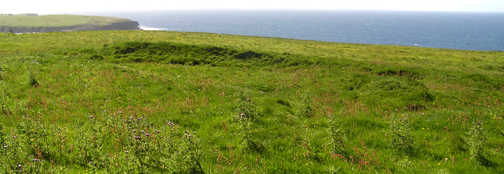
chambered mound from quarry, ‘passage’ seen as gap in this view
Image credit: wideford
chambered mound from quarry, ‘passage’ seen as gap in this view
atop mound looking to curving passage near northern end

natural +/ ‘quarried’ broad curved passage roughly E-W across it

closeup of ‘bent’ stone from earthfast ‘cluster‘

opposite view of stone ‘cluster’ alongside present mound
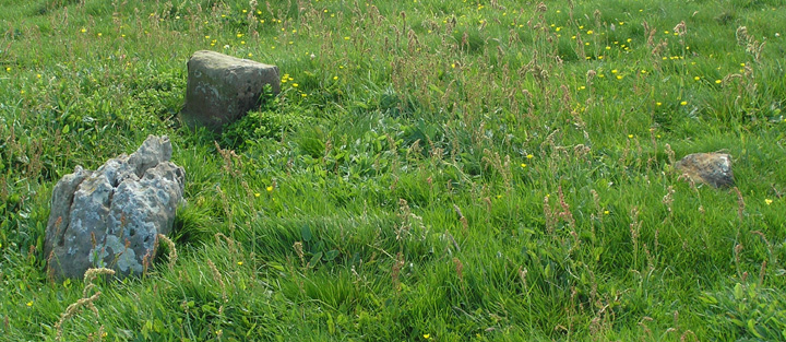
stone ‘cluster’ from arc alongside present mound

stones along supposed arc, resting in a depression side-by-side

first of standing stone ‘fence’ running across mound cliffwards
On the way to Skaill it struck me that the deep excavation arc could have been taken as a robbed broch wall. Despite modern misgivings as to the mounds composition and location perhaps this was exactly what happened, and the antiquarians were privy to personal accounts that haven’t come down to us (what little we know of Thieves Holm, for instance, are the odd few second-hand references)? Coming back from the Knowe of Angerow popped in here. In one area the most ginormous flat-top mushrooms about six inches across. Looking around a little poking found one of the many stones said to make up this mound. Very distinctly reddened, surely the sign of heating. Considering the number of burns there were on the slopes down from here to Skaill we could well be looking at your typical crescentic burnt mound (te passage and cistoid remains). And its present size could then be down to later additions that changed its nature. Of course it is likely to go even further back, the terminus of a sequence of mounds ?starting with the Knowe of Angerow and continuing with the Knowe of Nebigarth and the Velzian mounds etc.
Rather than go the route I went by the straight ascent up the hill. From Skaill House you can see the line of two field walls running from behind Skaill Home Farm (originally The Mount) all the way to the top. From near the site of Brockan (HY23031797, the now dry deepcut streambed that gave its name to the Knowe of Geoso lying in the same field) looking across I saw a low flat hillock and a small peaky mound. When I had a closer look I saw they were the same site viewed looking from the SE along a curving hollow. Which means that from down below the whole of the flattened hilltop is the knowe. So it feels quite large when you get there. I was also surprised to find that from this ridge you can see not only all the way down to the Bay of Skaill and across but also down to the Broch of Borthwick (built on the site of an earlier structure) and beyond. A view as near panoramic as another chambered mound at Hurkisgarth (HY25451770) – perhaps in part these functioned as early precursors to the ward hills ?
Though at this time the grass is lower here than at the likes of the Hillock of Breakna the supposed cist slab would still be rendered invisible. There seemed to be various depressions underfoot but the most obvious feature is that deep large curved ‘passage’ carving up the mound. The knowe is described as “greatly mutilated by quarrying” which I doubt would be the case if this had been a simple mound of earth and small stones. I imagine more obvious stones having been extracted long ago, but there could well be some left below the present ground surface.
Perhaps my assumption of larger stones within the mound does relate to the O.S arc of earthfast stones just outside the area of the mound itself. Not having remembered about these I approached them afresh. What took my eye first was an apparent grouping of three of inconsistent appearance – one of bent bi-cuboid shape, one a small flat rock, the largest cracked and pockmarked – but these were merely the tops of these earthfast stones. Forgot to measure them but the smallest was on the order of a foot across the shortest dimension. This grouping is near the middle left of the mound. Nearer to the southern end lie two triangular stones against each other, one much larger than the other. These rest in a distinct depression that is additionally marked by different vegetation from that surrounding.
The mound sits above a crossroad of fields. The wall coming up from the farm and the two that run before its southern end are drystane walls. But running over the mound and down towards the seacliff is a standing stone ‘fence’ (from Brockan my camera picked out the ?first of these stones). This is reminiscent of the magnificent one across the Hill of Borwick on the way to the broch from Yesnaby.
From the knowe the more physically able might enjoy the walk down across the field to the right and try to pick out the burns and drystane structures from the probable remains of the dwellings of Rowhall (HY22861808) and Westfield (HY22831813).
On to the bay side of Skaill House to try and locate the Knowe of Geoso. Even using the map I had a terrible time finding my bearings, as if the two regions of paper and land held only the flimsiest of connections to one another. Walk to the edge of the far house wall corner and look across uphill. It is easy to see the triangular scar of quarrying in the top right corner of a field. The cairn is just by the top right corner of the field diagonally opposite (though outside of it a fraction). Might have made it out on the horizon from here, wasn’t sure. Spent so long thrashing out my bearings making my way through fields of cattle to it felt beyond me. Saw drivers going to Skaill House Farm, which looked a simpler option, but making the grand detour to get onto that road in the time remaining was problematical. So I gave up for now at least.
RCAHMS NMRS record no. HY21NW 19 at HY22821792 is an overgrown eminence of small stones and earth generally called the Knowe of Geoso. It was [?]mistakenly thought to be a broch by association with the dwelling of Brockan in the diagonally opposite corner of a field below [itself now mistakenly placed at the quarry in the adjacent field’s corner, Brockan here being a name which like the Hillock of Breakna signifies ‘broken (hillside)’]. This turf-covered mound despite much ‘quarrying’ is still about 0.8m high and roughly 25m across, and has barely breaking the surface in the exact centre a 0.4m long slab that could be what remains of a cist. To the SE [i.e. immediate left as you come up from Skaill Home Farm] there lie nine stones of more monumental size in an arc that probably preceded the knowe, having significant weathering and not sharing a commonality of centre with it.


