A first-class monument, in my opinion.
Image credit: Robert Gladstone
A first-class monument, in my opinion.

If at first you don’t succeed Mr. Kidd?


Hill fog (hence the visit) accorded a rather intense vibe to this substantial monument...

The substantial capstone...

Suffice to say, the location of this heavily overgrown monument is not exactly advertised on the ground. My third time of asking... (the first unsuccessful through my ignorance; the second curtailed by a young, hostile ‘farmer-type’ trying – and failing comically – to berate me for straying from the path... while farcically having no clue whatsoever as to any ‘burial chamber’ on ‘his’ land)... this was actually well worth the perseverance over the years. In retrospect, an audience is easy enough: approach from the east, not via Sling (i.e. the Chwarel-goch road, where a former ‘phone is annotated upon the map), head through the metal gate and look to enter the field to your left as SOON as possible... then follow the line of ‘telegraph posts’ uphill into the trees.

The secondary ‘burial chamber’....... the image quality is indicative of the conditions.

The secondary ‘burial chamber’.......

The secondary ‘burial chamber’.......

The secondary ‘burial chamber’.......

It’s overgrown and little visited, but still a winner of a site.


Capstone and potential moved orthostat.

There is a substantial broken slab underneath the capstone, though whether a fallen side slab or a broken piece of the cap itself I can’t say.

The massively thick capstone.

The fallen stone is at the foot of the telegraph pole. In failing winter light.

The “bonus” fallen stone. Badly overgrown, you need someone to point it out (and preferably produce some shears).

C.B just for scale

The capstone from just 10m away, this is the first glimpse you’ll get of sling

Looking North

Follow the telegraph poles for Sling proper

This stone be it burial chamber capstone or fallen standing stone is 8ft long
You can just see the footpath sign by the side of the road

The Sniper stone . Well hidden
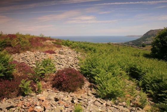
Anglesey in the far distance

The fifteen ft long capstone

Looking South-west

Note the telegraph pole behind the chamber ,follow them and they’ll lead you straight here

Looking south-east


Sea view.


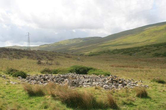
Little remains of this site.
Finally, it is happening to me … an audience with the great chamber.
Now, despite being well aware that a visit to Sling – or Frondeg, if you prefer – was long, long, long etc. overdue, a spare hour or so before dark... in absolutely appalling conditions... and with a hole in my left boot, to boot.... probably did not constitute the ideal circumstances to introduce myself to the area, to be fair. But hey, what could possibly go wrong? I mean, how difficult can it be for a guy long practised in locating obscure cairns upon hill-fog cloaked summits to find a monument a couple of hundred yards from the road? No, really? But there you are. Clearly, since I never actually located the featured monument, I’ll need to return at some point. Preferably not in a torrential downpour conjoining with near-zero visibility to fiendishly diabolical effect, though...
The reason for this lamentable personal muppetry is simply that, like Ironman before me, I had no doubt whatsoever that the secondary ‘fallen stone’ first encountered when leaving the public footpath represented the capstone of a burial chamber (possibly earth-fast?) supported upon what I saw to be clearly defined orthostats, the whole surmounting the remnants of a cairn.... albeit covered by industrial-grade brambles such as to cause even Br’er Rabbit to pause to consider options. Or, to put it another way, THE burial chamber I’d come to see. As that Kurgan bloke said in Highlander, ‘There can be only one’. Who’s ever heard of two such monuments so close together in North Wales? Malin More, yes, but Gwynedd? Naturally, the fact that, as usual, I had not done my homework – and therefore was not aware of the specifics of what I was actually looking for – duly negated the need to venture further into the soaking mist. So that was that.
What particularly puzzles me in hindsight, however, is the almost total absence of detail upon Coflein – or, indeed, anywhere online – concerning this secondary site? How can such an obvious – to me and Ironman at least – burial chamber not have generated some interest? Hey, any interest at all? Does anyone know what was going on here back in the day, because it seems to me that here we have nothing less than a megalithic cemetery slumbering amidst the quarrying residue west(ish) of Bethesda? Browsers of the ‘Archaeologia Cambrensis’ – see link – will notice that pages 62-63 of Volume 13, Series 3 give a brief mention of other internments being discovered in the immediate locale c1855 (to judge by the somewhat nebulous ‘nearby’).
Needless to say, I fully intend to have another look at some later date and form my own opinion... with my own eyes. I hope I have the opportunity since despite – or perhaps even because of – the inclement weather, I sensed this place is the real deal. With a story that deserves to be told.
After parking by the phonebox cross over and go through the turnstile and on to the footpath,follow the path with the hedge on your left, after 50 yards a gap appears go through and up the hill to the nearest telegraph pole. Just at the foot of the pole is the first stone 8ft long and positioned in an east-west line,pointing through the hills and on to Anglesey, almost covered in moss and ivy but nearly free of gorse it’s next to impossible to find unless you know where it is. Unless it’s been excavated and proved to be a burial chamber I’d be inclined to see it as a fallen standing stone, what’s the chances of there being two chambers of so different styles so close to each other?, then again what do I know.
From here follow the telegraph poles southish into the trees, It’s only 50-60 yards away from the other stone and slightly downhill, your first view of it will be from behind the capstone.I spent a good hour or two chopping back the undergrowth of brambles, and removing all the deadwood. The capstone is fifteen feet long and rests on just one upright, it is aligned N.W-S.E and you could just about get in so long as you lie down. The chamber seems to have at one time been built into a dry stone wall because at least two denuded and broken down walls converge on the site.
Two blokes with a truck and the right gardening equipment could in just one day change this place from unknown and overgrown to delightful and charming ,somewhere you might expect to see fairies,two or three trees removed and the views would open right up.Having said that despite the scrub and tree cover this place remains very nice and good to find.
The first time I came here it was a total surprise expecting to see just the overgrown boulder, when I saw the obvious chamber and it’s capstone I felt like Indiana Jones in the Raiders film when he says about the bad guy” he’s dgging in the wrong place”.Untill someone else comes here I will pronounce this place MINE
If you do come bring the machete and have at the brambles.
The roads are confusing but follow the os map and youll be OK ,park by the phonebox and on the other side of the road is a footpath proceed and turnleft off the path uphill, go past ironmans stone and into the trees the chamber is well hidden ,but the capstone is huge and obvious propped up on one orthostat.no view is possible because of dense vegatation,flippin CADW just dont seem to care sometimes
This site isn’t easy to find, the roads round here are very confusing. We asked a friendly local for directions and he got straight in his car and led us to the spot – what a dude. The site is a disappointment, very little is left, and what there is lies overgrown. The location however is good, with a view stretching from the Snowdonian mountains right out to sea.
The only existing cromlech in the parishes of Llanllechid and Llandegai is situated in the upper part of the parish of Llandegai, near a small farm called Ffynnonbach. It goes locally by the name of “yr hen allor” (the old altar), and tradition, as usual, ascribes its erection to the Druids; and the use to which it is said to have been applied, is indicated in its being called an altar. But that the cromlech was a mere burial-place, has long since been settled. The cap-stone measures in breadth 5 feet; in length, 14 ft. 5 ins.; in thickness, about 1 ft. 6 ins. throughout.
More on the state of the stones in 1867, along with associated finds, in volume 13, series 3 of Archaeologia Cambrensis, viewable at the Internet Archive.