Mynydd y Dref from the southwest, above Gwern Engan.
Image credit: A. Brookes (10.11.2023)
Mynydd y Dref from the southwest, above Gwern Engan.

From across the Afon Conwy at Deganwy the hill’s rocky prominence is even more apparent.

The changing face of fortification. Castell Caer Seion overlooks the medieval walled town and castle of Conwy. Both sites command the approach over the Afon Conwy from the east.

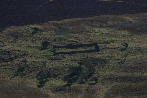
The rampart along the southern side of the eastern section. Natural slopes play a large part.

Neat hut circle towards the eastern end of the fort.

Looking towards Tal y Fan.

Looking from the Citadel towards the eastern part of the fort.

The seaward side of the fort.

The massive stone rampart of the Citadel at the western end of the fort.

The entrance, with impressively surviving stone courses on either side.

Another view of the circular structure to the south of the entrance.

Strongly walled circular structure to the south of the entrance to the “citadel”.

Conwy Mountain and Castell Caer Seion from across the Conwy estuary on the Great Orme.

The camera battery emptied itself shockingly quick, but after a short walk over here it found the power for half a dozen more pictures.

Looking east over the entrance of the fort to Conway.

With skies like that it was absolutely astonishing that some actual sunlight should find it’s way down to me. until now I thought sunshine had gone extinct in North Wales.

Looking over an exterior entrance to Conway.

Low cloud, hail, rain and sunshine and an inexhaustible amount of brutal wind all in one short trip to a hill fort.

A good little hill fort, looking west to the north rim of cloudy Snowdonia.

Looking west over the entrance


The sun’ll come out tomorrow.

From several miles south east of the fort.
Ready for take off ?

Looking East into the fortification, with sign.


Looking north, with hut circles and conwy morfa below.

Looking back westerly, with a storm brewing, December 2010.

The South eastern wall.

The Western approach.

looking towards the hill fort from Penmaenbach.

Looking towards the superb Edwardian castle and walled town of Conwy which superseded this Iron Age settlement.

Looking towards Conwy (note the superb castle and town walls, upper right) from Mynydd-y-Dref

Badly vandalised information plaque at the site.

Possible gateway to the hillfort?
After dropping the kids off at school and collage I decided that it has been too long since I last went out, it’s payday and there are blue skies and fluffy white clouds overhead so I grab me stuff, jump in the car and head out west.
The weather in Wales and me don’t get on all the time, in fact we argue constantly, I want sunshine and rainbows but Wales doesn’t care what I want so it tries it’s level best to deter me from coming at all, today was no different. The head sized hailstones half way there almost made me turn round but i’m more persistent than that.
By the time I parked in the car park the weather had settled into murky low cloud, the fort is visible on the euphemistically named Conway mountain, but there is no direct route, so a half mile walk east down the road to a crossroads turn left on to a wide footpath follow that up hill till you get to a T junction of footpaths, left again, when a right turn going uphill presents itself take it for a now direct route to the “citadel”.
Upon my return home and looking it up on Coflein I can see that the hill fort proper is much bigger than I thought so all I had a look at was the citadel, don’t make this mistake.
The citadel, I will continue to call it this, just for a laugh, takes up only a quarter of the entire fort, but it is the best preserved part, actually it has been partially restored if the pictures on Coflein are anything to go by.
I’ve been trying to find the time to come here for a couple of years and so far the weather is kind of cooperating, the wind is very strong but the rain passed by just a couple hundred meters away. I only spotted two definite round house platforms, there are more.
The battery in my camera now chooses it’s moment to let me down, so I swear loudly at it, it doesn’t seem to have any effect. I take it as a sign that it is time to go home and pick the kids up, but I stroll side ways over to a vantage point across from the fort and whisper sweetly to the camera, it allows me a few more photos, that’s why we anthropomorphise.
I don’t fancy retracing my steps laboriously back to the car so I try and head back in a straight line, it didn’t go well, two barbed wire fences, a wall and a small stream have to be crossed whilst keeping out of view of the two nearby houses, it was more fun but it probably took longer than the right way.
This fort is on the summit of Mynydd y Dref (Conwy Mountain). It has 24 hut circles inside, and some outside its walls. There’s the remains of a larger building (a ‘citadel’ so Coflein grandly says) at one end of the fort.
This from ‘Notes and Queries’, March 12,1870.
I have [examined repeatedly the] remains on Conway mountain. They are intensely interesting.. They consist of a multitude of circular structures partly sunk below the ground, with rough walling a little raised above, evidently the substructure for huts... They are called by the country people “Cyttiau Gwyddelod,” which is generally interpreted ” the huts of the Irishmen,” but which in its primary meaning is “the huts of the savages,” or wild men, in contradistinction from the Gal, or agricultural race.
‘Cytiau’ (so I understand from the dictionary) does imply a rude kind of hut, more of an animal shelter, so this could be a dig at the Irish?? Or maybe not at all. Maybe a Proper Welsh person can explain the subtleties of the phrase for me.