On super zoom from Penygadair, settlement by the trees
Image credit: Chris Bickerton
On super zoom from Penygadair, settlement by the trees

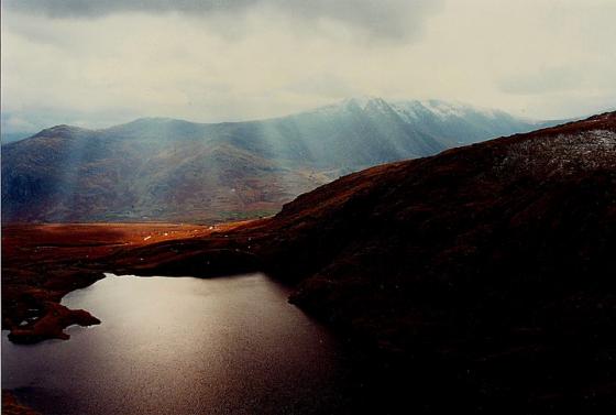
Looking along the valley of the Afon Melynllyn from the steep track connecting Llyn Dulyn to Melynllyn reservoir. An area now devoid of people was busier millenia ago.

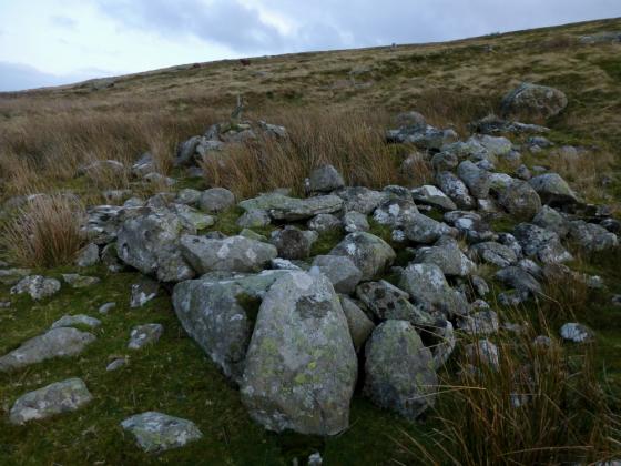
Large, circular enclosure at the western end of the settlement.

Looking SW up the course of the Afon Melynllyn.

Looking towards the neighbouring settlement of Clogwyn-yr-Eryr.

Remains of walls at the eastern end of the settlement.

The Afon Melynllyn provides the settlement with plentiful running water.

The spectacular siting of the settlement, below the main NE-SW ridge of the Carneddau. The cliffs guard the eastern approach to Foel Grach and Carnedd-uchaf, Foel-fras rises on the right of the picture. Despite being situated above the 500m contour, the settlement feels sheltered.

The settlement stretches from the trees to the cloud shadow on the left, quite extensive.
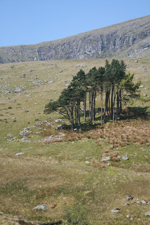
the hut thing beneath the trees

Looking east towards the Afon Conwy


Looking south towards Craig Eigiau

As seen from Craig Fawr above the two lakes Dulyn and Melynllyn
Zooming in from Craig Fawr above the two lakes Dulyn and Melynllyn

According to the map the settlement site lies to the fore of the (I think) bothy. Bronze Age monuments stand upon the summit of Foel Grach [left skyline] and (possibly/probably) Garnedd Uchaf [right skyline]. Llyn Dulyn lies hidden beneath the overpowering cliffs of Craig y Dulyn.

Approaching above the Afon Dulyn upon the Llyn Eigiau/Melynllyn track.... the (very) approx site of the settlement is indicated. Foel Frach, bearing massive cairn – presumably Bronze Age in origin – shows its rocky summit centre skyline. Carnedd Llewelyn, sentinel mountain of Y Carneddau, peeks over the ridge, far top left.
We carry on down the slope to the little river; the intervening ground requiring some bog-hopping. Lucky the weather has been dry, this could be a bit of a problem in wetter conditions. The eastern end of the Pant-y-Griafolen settlement can now be seen under a small stand of trees, from where it stretches away upstream towards Llyn Dulyn. The Afon Melyllyn is easily crossed on plentiful stones, even in spate I don’t think this would cause a well-balanced visitor (that’s us) too much trouble.
Like the nearby Clogwyn-yr-Eryr settlement, this is not well-preserved, little more than circular rubble rings remaining. It is however extensive and fantastically well-placed. It’s hard to reconcile the fact that the site is 530m above sea-level with the degree to which it feels sheltered from the elements. The surrounding Carneddau ridges are so much higher that we are completely out of the gale force winds that are blowing over the tops today. You can almost feel the presence of the people, or perhaps they can almost feel ours. I could happily stay for a while in the sunshine, but we have hardly begun the hard work of the day and so we press on.
From Castell, north of Tal y Bont, overlooking the Afon Conwy, go west, the turning is right next to the Afon Dulyn, but the river can’t be seen from the road so look for the pub named Y Bedol and take the first turning east south of it. (hope that made sense)
This eastward road is one car wide for most of the way, it’s steep and winding, but it looks over the river valley shaded from the fierce sun by trees, it’s some truly beautiful countryside.
The road straightens out and goes past where you should park for Hafodygors wen fourposter stone circle. just keep on the same road until it runs out and park here, room for maybe twenty cars, but in good weather it soon fills up.
Upon exiting the car, south east is the small mountain of Moel Eilio, with bronze age settlement, south east is cairn topped Pen llithrig y Wrach. But we turn our backs on them and follow the well laid and often trod path to Clogwyn-yr-Eryr, superb views north east to Pen y gaer, and when you get round the corner and heading west and south west, we pass by a possible stone row. Keeping on, the path delves further and further into the mountains, off to the right of the path is a small settlement, we stopped for a nosey, as you do, but the big places beckon and we’ve a long walk ahead of us, so off we go down the hill. From a distance, if you know where to look the settlement of Pant y Griafolen can be seen from miles away. We ignored the path beseeching us to go that way, and went this way instead cut straight across cross the river it isn’t deep or wide, heading for a stand of pine trees with an obvious tumbled stone wall beneath it.
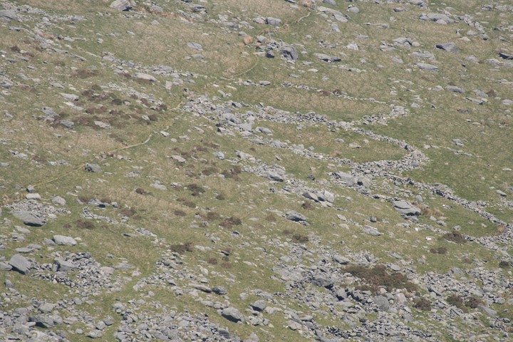
Pant-y-Griafolen was..... is ... a large settlement, the best way to see it would be to hover about fifty feet above it. Only the most obvious of walling can be seen, a number of hut circles, not
the reputed thirty. But then we weren’t here for extensive field walking, no hut counting, just passing by, playing through. Our long walk intends to take in three mountain peaks two with cairns, it’s very attractive to think that the occupants of one of those cairns could have lived here, perhaps in that large hut circle right there.
This isn’t the best preserved of settlements, but hey it’s over three thousands years old, that’s twice as old as say, Mayan Temples, when three thousand years you reach look so good you will not.
There are traces of a serious number of round huts here. Coflein conscientiously lists each one (there are nearly 30) but is forced to say ‘hard to discern in the field due to fairly extensive stone scatter’. The huts lie handily along the course of the Pant-y-griafolen stream. Some of its water comes from Llyn Dulyn, ‘the black lake’, which is very close by and was a natural lake adapted as a reservoir in the 19th century.
The dark lake has some strange folklore, as such a dramatic place might:
The extraordinary property of producing rain, when spilt upon a stone, is attributed to the waters of Llyn Dulyn, in Snowdon, according to the following account, which is translated from the Greal, a Welsh Magazine, published in London, 1805.
“There is a lake in the mountains of Snowdon, called Dulyn, in a rugged valley, encircled by high steep rocks. This lake is extremely black, and its fish are deformed and unsightly, having large heads and small bodies. No wild swans are ever seen alighting upon it (such as are on all the other lakes in Snowdon), nor ducks, nor any bird whatever. And there is a causeway of stones leading into this lake; and if any one goes along this causeway, even when it is hot sunshine, and throws water so as to wet the furthest stone, which is called the Red Altar [yr Allawr Goch], it is a chance if it do not rain before night.
Witness, T. Prys, of Plas Iolyn, and Sion Davydd, of Rhiwlas, in Llan Silin.”
This is mentioned in Lady Guest’s version of the Mabinogion, online at the Sacred Texts Archive (p77).
sacred-texts.com/neu/celt/mab/mab09.htm
Much nastier, is this from chapter one of Marie Trevelyan’s ‘Folk-lore and folk-stories of Wales’ (1909):
This black lake is supposed to be an extinct and fathomless volcano, and shepherds in the surrounding mountains used to say that the appearance of a dove near those black and fateful waters foretokened the descent of a beautiful but wicked woman’s soul to torment in the underworld.
In the seventeenth century people believed that if anybody had the courage on one of the “three-spirit nights” to watch beside Llyn Dulyn he would see who were to die within the next twelve months. Fiends would arise from the lake and drag those who had led evil lives into the black waters. Those who had led good lives would be guided past the causeway leading to the lake, and vanish in spirit forms robed in white. A reputed witch disappeared from the district, and a shepherd said he saw her being dragged into the black waters. [A.B.]
Online at V Wales.
vwales.co.uk/ebooks/welshfolklore/chapt1.htm
Its malign influence has obviously continued to have effect, as in 1942 a plane crashed into the tall and foreboding rocks behind, and pieces of it eventually wound up in the lake, where they are yet.
This forms quite an extensive settlement beside two of the darkest lakes in all Snowdonia.
Unable to log any actual ‘fieldnotes’ since I was merely a’ passing by at a distance... en-route to the Bronze Age monuments crowning Foel Grach and Carnedd Llewelyn rising above. Yeah, at my age a diversion was asking a tad too much, it has to be said. To be fair this is remote enough.... a stunning location, well worth a primary visit. Perhaps another time, when the knees finally call ‘enough’.
The cliffs of the aforementioned Foel Grach tower above, the harsh call of the crow – hey, perhaps even raven – echoing from the rock face (bless... probably sounds pretty sexy to another crow). What an incredibly extreme place to make your home! However seen in the low early morning light, methinks this is truly exquisite. The truly fit may wish to make a call before – or after – a visit to the high Carneddau peaks. If so, I salute you. Hell, I salute you if you come here anyway. The world needs people willing to do such things.
The easiest route here begins at the road terminus at Llyn Eigiau... the drive to this point quite an adventure in itself, with numerous other monuments in the area, too. Follow the green track to the approx north-west (i.e. not the one leading to Llyn Eigiau) and... depending on your point of view... either take the second right hand path to arc around to the north (not done this myself) or stay upon the main track and make your way across the Afon Dulyn as best you can.
Ah, Y Carneddau. Every great cairn needed people to build it, to make it much more than a pile of stones. Places like Pant-y-Griafolen were where such people lived.