Three Go Mad In Conwy: Part I
Jane and Moth were visiting us for Easter, so it was appropriate that a reasonable day's megalithing be arranged. After ascertaining Jane fancied a few big, glitzy Hollywood-style sites, a route was planned which took in choice attractions from the last 6,000 or so years. Knowing the girl loves a good sweeping canvas, the inclusion of two sacred landscapes was considered an essential feature of the day's trip. The only problem was that (as with much of North Wales), reaching them involved walking. Jane doesn't do walking. If she knew in advance that walking was required, Moth and I would definitely be suffering from ear-ache come lunchtime. How was I to get round this? Easy. We were going on a Megalithic Mystery Trip . . . .
The Art Of Seduction
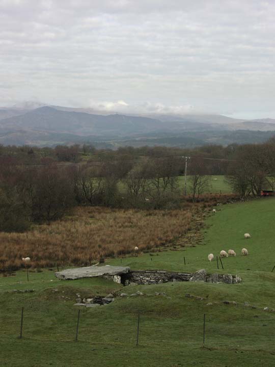
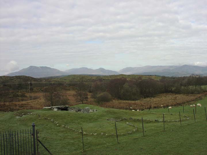
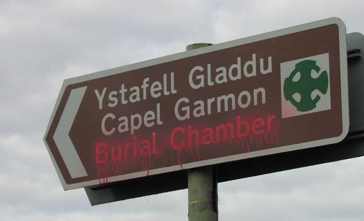
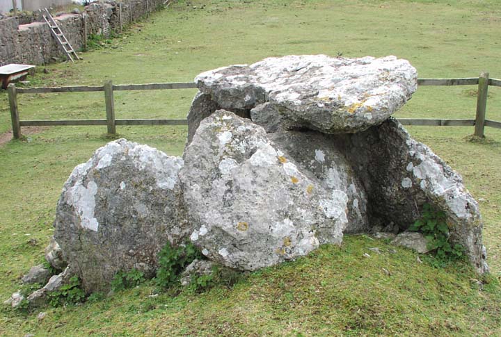
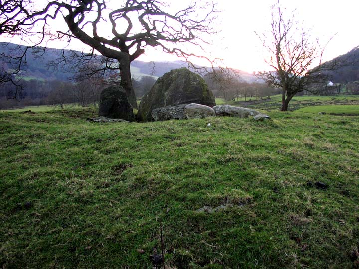
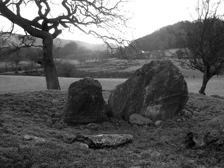
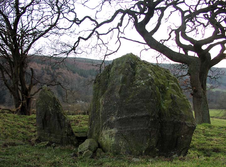
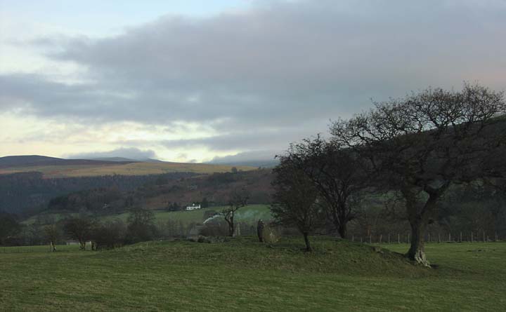
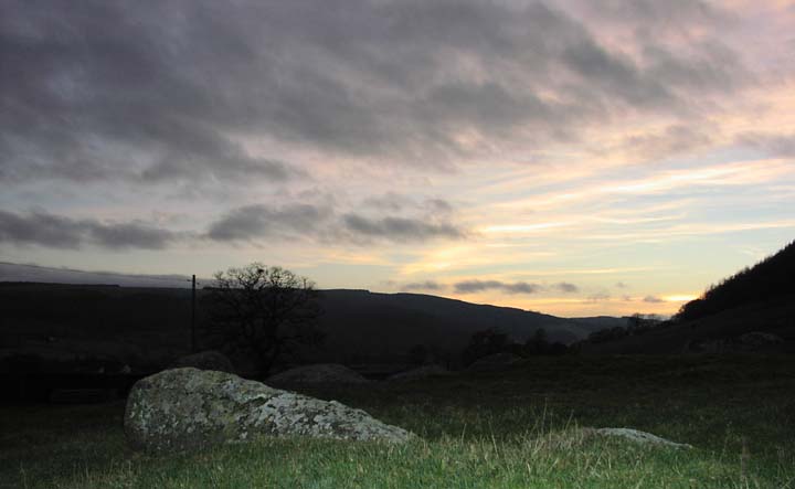
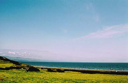
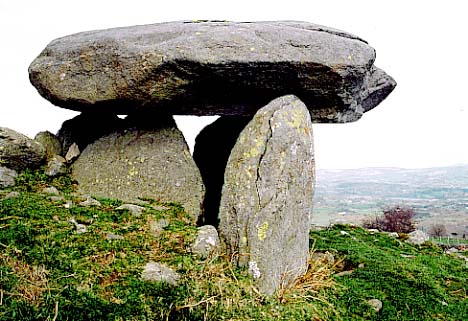
We left at 8:00am sharp, the same moment as the Ginster's Pies-sponsored passenger train rumbled along the railway line at the back of our house. This was generally perceived as a good omen by the three of us (the arresting Kate was at work), and indeed it was – after stopping for coffee at Rhug Organic Farm Shop, and spotting four waxwings by the roadside, we arrived at Capel Garmon in exactly an hour. Although thick fog had bedevilled us for most of the journey there, it petered out shortly before the turn off into the rolling hills leading to this magnificent burial chamber.
Another effective method the arresting Kate employed to seduce me. She brought me here on a glorious blue, russet, and gold autumn day, and blew me away. This place is so beautiful, peaceful and completely breathtaking.
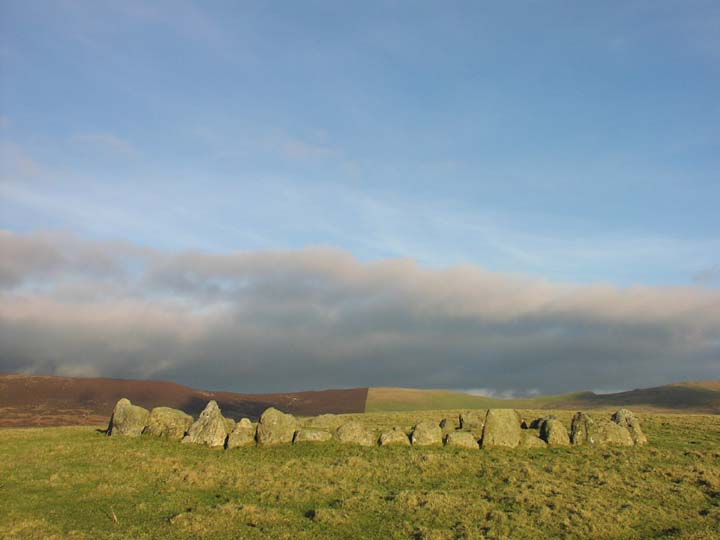
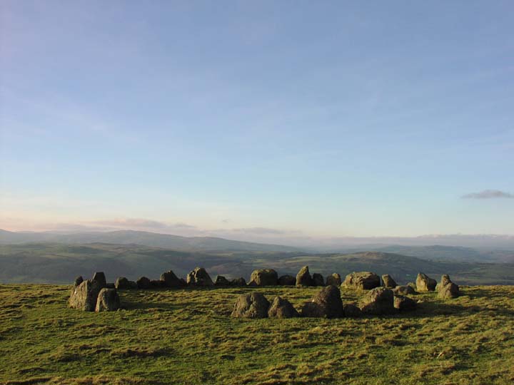
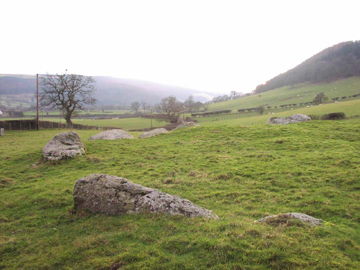
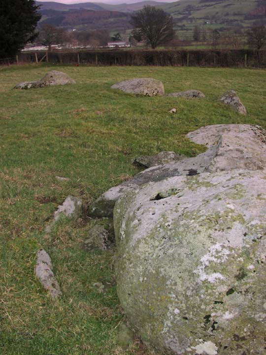
When Jane, Moth and I visited, a misty, slightly overcast sky greeted us, and lifted as we left – typically. Nonetheless, a superb view of Snowdonia was afforded which demonstrated beautifully why the ancestors chose this site. As ever, the placing of a Severn-Cotswold long barrow in the heart of North Wales fascinated me. Who were the builders? Were they a group of people who moved up from the south? Were they a tribe who had taken on different belief systems to the others prevalent in the vicinity? Were they traders? There are no such barrows anywhere else up here, so I assume this must be the case. Or could it have been the last one to have been built before that set of beliefs changed? Or is the only one that has survived?
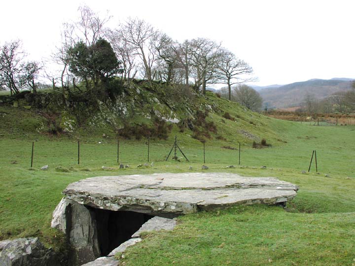
Whatever the reasons, this is a fabulous structure, definitely worth a visit. The remaining capstone (on the western chamber), is awesome, and it is easy to imagine how the thing must have looked when originally built. The post and panel work inside the chambers is a joy to behold, and even though it has been extensively restored, remains of the original dry walling can be seen in the lower courses of the eastern chamber. 5,000 year old dry walling. Cool.
We enjoyed a good half hour here, joined briefly by two other visitors, and watched by many fluffy sheep.
This Is A Local Rock For Local People
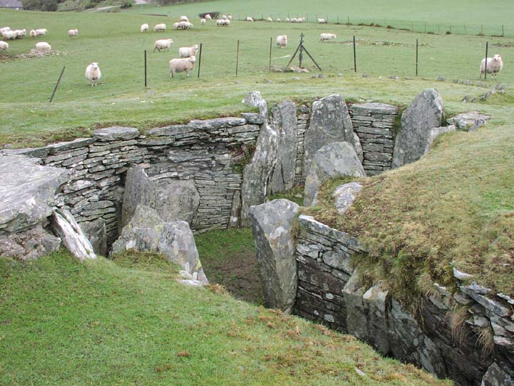
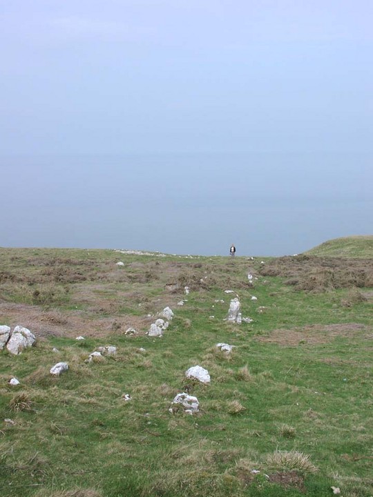
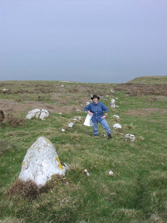
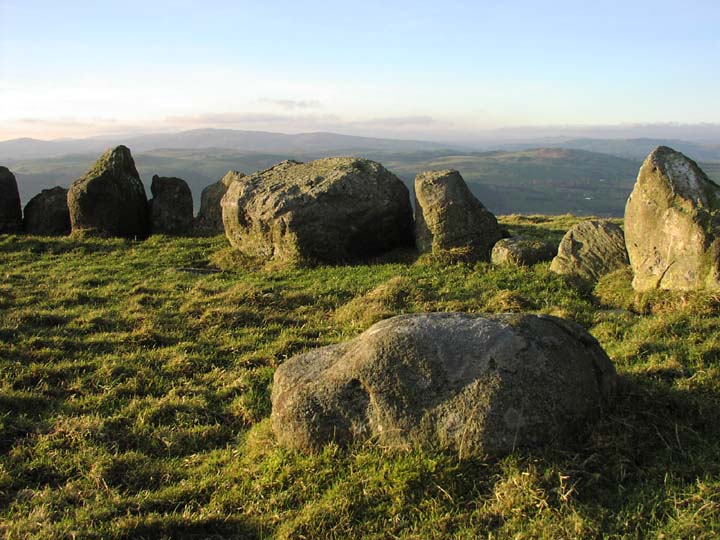
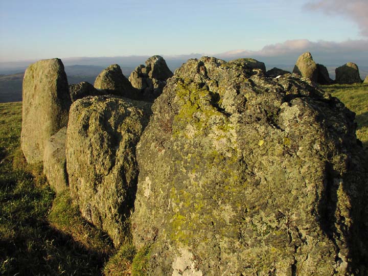
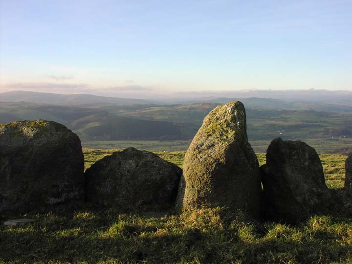
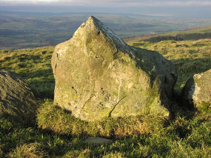
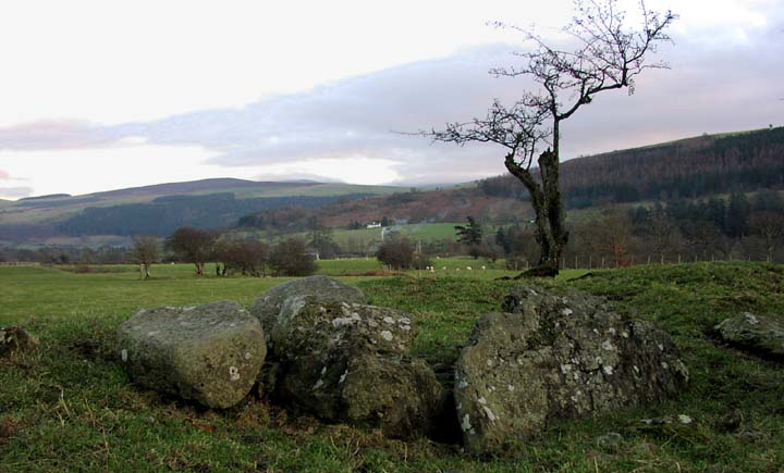
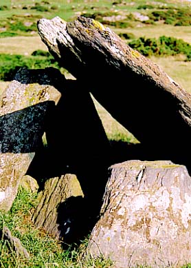
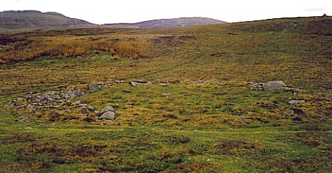
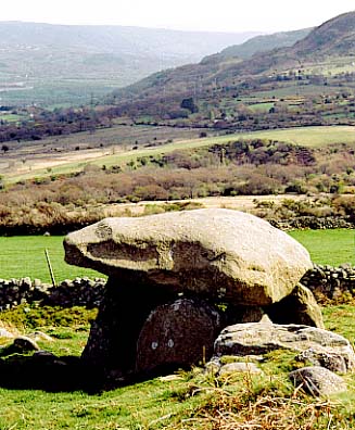
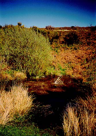
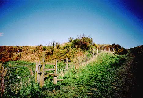
Leaving the bouffant sheep (and no mention of walking), we continued on up the A496 to Hendre Waelod or Allor Morloch, a dolmen I was particularly keen to see, and which Jane had also requested. We drove down a narrow lane until the metalled road on the map finished, and parked in a convenient gate-hole. A local pedestrian was intrigued by our presence, coming back to check on us, not once, but three times. We were definitely suspicious. However, once she saw a bearded chap wearing cammo pants and a rucksack, a large blonde in cammo pants and fluffy jacket, and a mad woman sporting a bush-hat head off up towards the woods, she was satisfied that we weren't a chav robbing squad, and continued her constitutional.
Follow the footpath up to the right from the gate hole, turn right into a brambly snicket, then left, and stay against the hedgerow until passing into a small wood. There are footpath markers to assist. You will be able to see this intriguing chamber silhouetted against the sky-line. In your eagerness to get up close to the monument, which forms the edge of two raggedy barbed-wire fences, take two seconds to locate the kissing gate 50 feet up to the right at the edge of the wood; using it is infinitely easier than scrabbling through tetanus-loaded wire.
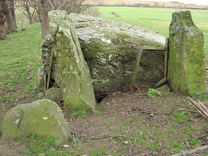
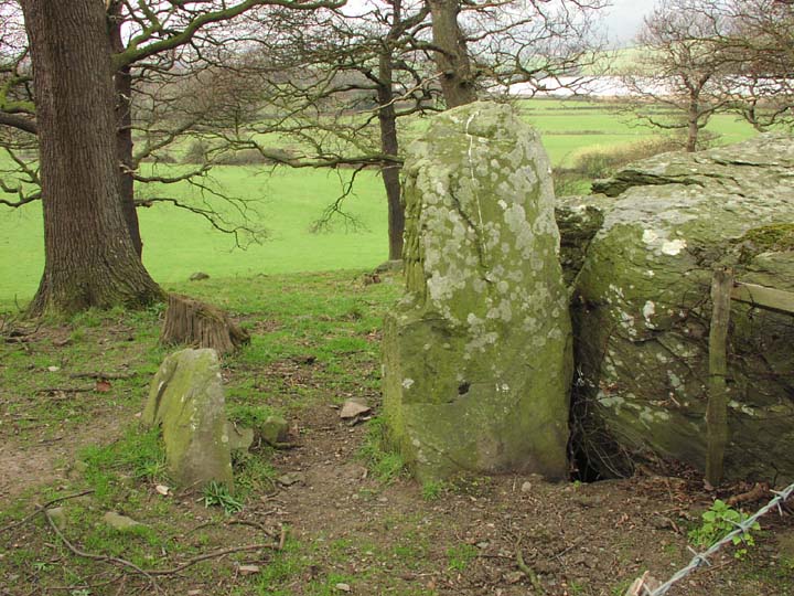
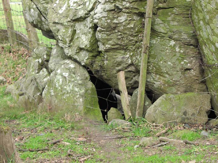
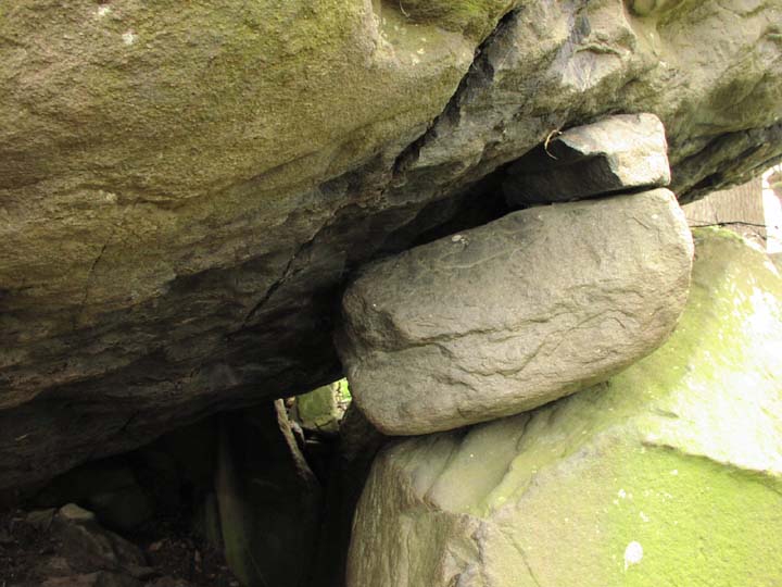
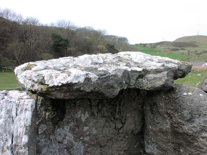
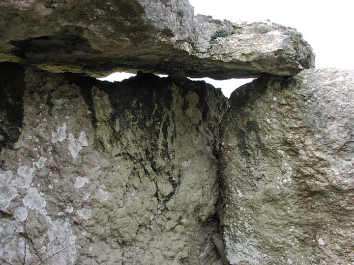
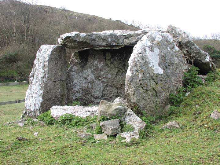
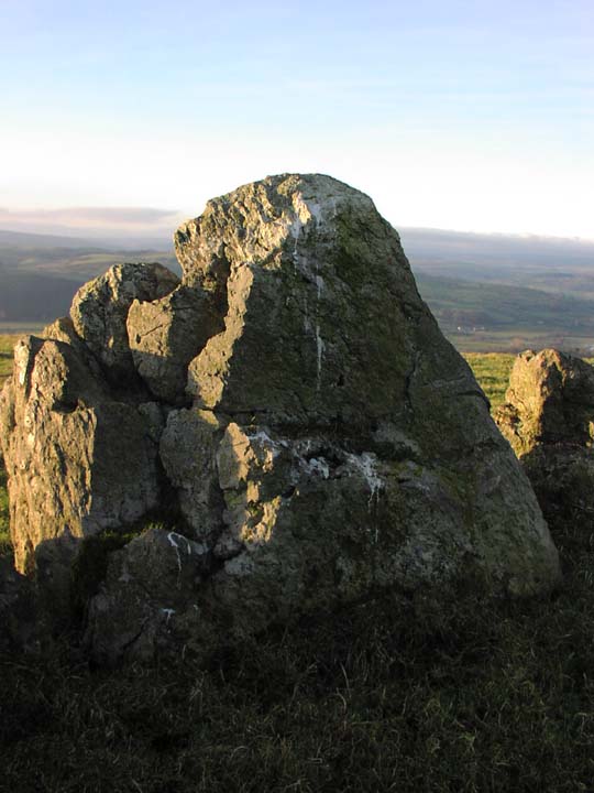
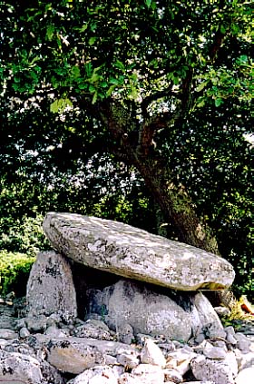
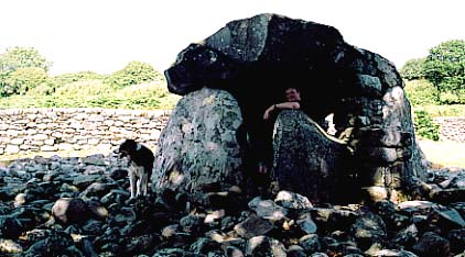
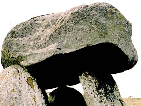
This secret, compact dolmen – the only one of the Conwy valley's portal dolmens sporting the customary high portal stones – looks down a tranquil bend in the Conwy valley, towards Llandudno and Great Orme. Although compact, it is deceptively huge from a distance, resulting in the viewer feeling a little surprised on arrival. What is most certainly huge, however, is the capstone. It is utterly gigantic. Despite the fact it has slipped down on the northern side, enough space remains to see the interior of the chamber. It is possible to wriggle inside, which I thought of doing until noticing how the capstone is held in place. (See pictures). Frances Lynch in CADW's publication Gwynedd says this is not for the squeamish. Quite right she is too – I didn't fancy the idea of being crushed by a ten-ton capstone, albeit an appropriate way for a Modern Antiquarian to perish. With my wide beam-end, the dislodging of rocks one way or another was sure to occur. When the arresting Kate saw the pictures the next day, she said "Well, at least it would give you an idea of how it feels to be a grain of wheat under a quern stone."
Although I was initially a tad disappointed in this site, it has stuck in my mind, and on reflection, I enjoyed it very much. It does have something about it which lingers in the psyche. I liked the remaining portal uprights, and the solidity of the site. I imagine if there are bluebells in the wood, it will look most agreeable throughout May. We would have stayed longer – Jane could have made a fab painting of the river vista – but a chilly wind chased us away to the next site.
 |
Kennel Maid
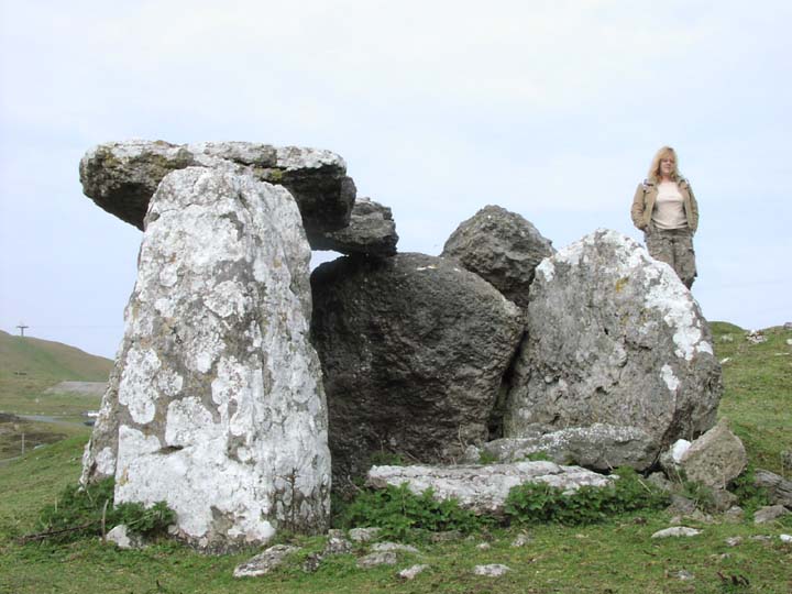
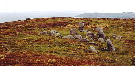
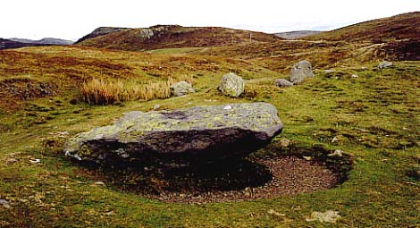
Still no mention of walking as we sped off to the next attraction on the list – not 'The Magic of Llandudno', but the pleasures of Great Orme. There were two sites of interest scheduled before lunch, lesser known than the Bronze Age Copper Mines, which are something we will do another time. First on the list was Llety'r Filiast.
'The Lair of the Greyhound Bitch'. Appropriately enough, the house next door had a yard full of dog shit and a pack of hounds who barked long and loud on our arrival. In addition, the throb of bitchin' rap emanated forth - rather distracting in the otherwise secluded and peaceful setting of this small dolmen.
Unfortunately, the diminutive chamber is crumbling slowly away, much like a piece of Cheshire cheese. Enough remains to reveal what a charming structure it was, and happily, it is obviously looked after, as a helpful tourist information board is stationed nearby. The puddingy stone put me in mind of Carreg Samson, although there was no variation in the stones used here.
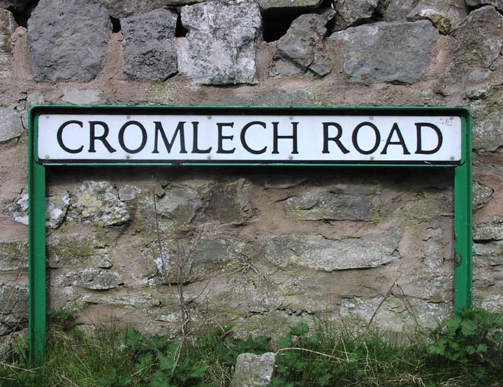
With its capstone in place, it would probably have appeared more dramatic, but sadly this broke in three or four pieces a while ago, and the chunks now lie where they fell. Remarkably, although access is very easy via the solid purpose built ladder at the foot of 'Cromlech Road' (big help, that), the site is very clean and tidy. I expected it to be 'The Lair of the Burberry Chavs', but there was not an empty bottle of White Lightening in sight.
Moth and Jane reckon that in its hey-day, Lletty'r Filiast would have been a similar size to Hetty Peglar's Tump, which mean it would have been a seriously important site. Its position so close to the Copper Mines (just a few hundred yards above), is also interesting. It wasn't as dramatic as I had hoped, but pleasant. At least Jane was bewitched, finding herself reluctant to leave.
Virgin of the Rocks
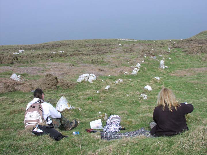
Hunger pangs were starting to jab as we set off to find Great Orme Stone Row. This did entail some walking, but not too much, and we had decided to picnic on pies and crisps when we discovered its whereabouts. Although marked on the map fairly well (along with some weird rectangular structure to the rear – suggestions, anyone?), we had a hell of a job to find it, spending a good twenty minutes tramping this way and that through dense heather and gorse.
Eventually, a cry from Moth (looking epic against the sky-line, a bit like Gregory Peck), indicated the secretive Bronze Age site – and my first stone row.
As our initial searching had been confounded by many erratics, the general consensus was that this might not be a very spectacular site. After hoping for something reasonably impressive, I was beginning to think this would be a few short, squat, piddly stones running in a line for 10-20 feet.
Thankfully, this wasn't the case – Moth finally located approximately 100yds of Bronze Age handiwork, made from substantial stones, leading towards the Irish Sea. What a treat for a stone row virgin.
As we took photos and generally prepared for lunch, a hale and hearty woman approached, enquiring as to whether this was the stone row. We informed her it was, and she asked if we were students of archaeology. I replied that we were Modern Antiquarians, so in effect students of archaeology, but really just megalithic enthusiasts. She explained that she was an ex-midwife who led walking parties, and was walking Great Orme to suss out a new route, with places of interest like the Roman well by the roadside above the stone row. We suggested she check out Lletty'r Filiast.
Amongst all the erratics, the uniformity of the stone row was very clear, and picnicking above them, I wondered what their purpose had been. Interestingly, they faced north-ish, so presumably the setting sun would not have been visible at their end. Could they have been a ceremonial route, or something connected with shipping? Moth said they reminded him very much of Dartmoor stone rows, and on our return to the car, we had an interesting discussion about the possibility of Cornish tin miners being drafted in to work the Copper Mines, bringing with them new customs and traditions.
Upon our return to the car, Jane mentioned that the 350m walk and time spent searching had been quite a leg stretch. I looked at Moth (who by now knew what was next on the list), and kept schtum. The next stop was the one that involved walking.
|
Berwyn Beauties
Sheds v Stones
After a lazy Saturday morning in bed, then discovering the weather was actually rather splendid, Kate elected to take the day off from work. Imagining she would be keen to continue with the current shed painting project (my beloved is never happier than when she has an open tub of Cuprinol nearby), I was pleasantly surprised when she said "Thought we might go megalithing this afternoon."
"Oooo," I replied excitedly,Glorious and beautiful, or stubby and megarakky?!"
"I think you need glorious and beautiful", she smiled, knowingly.
Consulting my library of ancient monuments and prehistoric structures, it didn't take me long to work out that Moel ty Uchaf and its environs would be suitably glorious and beautiful. Packing dogs and megalithing gear into the car, we headed out through Llangollen, following the Afon Dyfrydwy, or River Dee, singing loudly to Stevie Wonder's I Wish. Truly music to megalith by . . .
Pissed Off Puppies
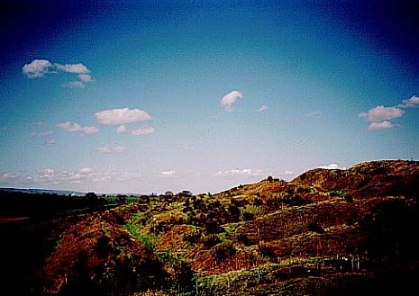
Turning left after Corwen, and dropping off the main road, we soon found ourselves driving into the less populated, gently swelling hills of Berwyn Mountain and its surrounds. The hills and mountains in this part of North Wales are soft and flowing, subtle yet imposing, yet possess an understated magnificence, something that can be too easily missed due to their close proximity to Snowdonia. Goddess symbolism, shape and form abound, the hills holding a timelessness and raw energy that our modern life eschews. From what little I have seen so far, North Walian sacred landscapes and their mysteries are somehow more tangible, more dominant, – the elemental cohesion sings in an entirely different fashion to that of the south of England.
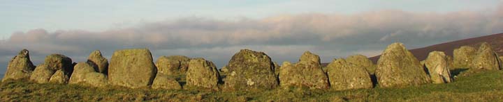
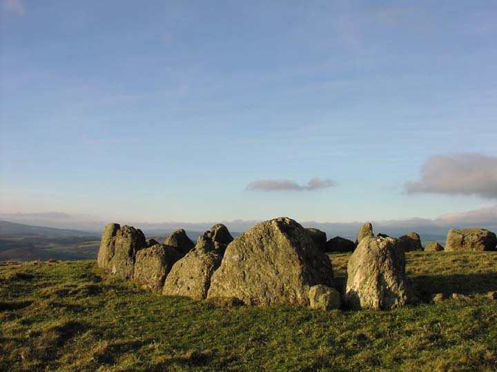
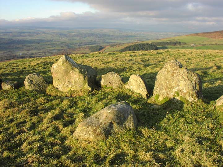
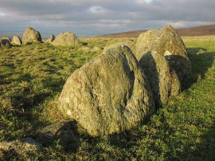
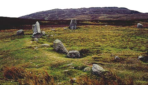
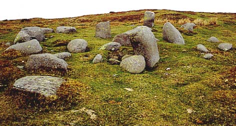
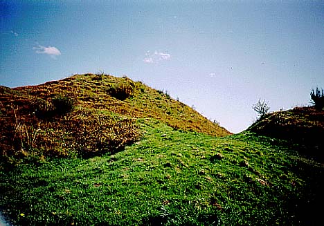
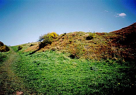
Blessed with rich afternoon light, we drove halfway up to Moel ty Uchaf, and left the car when the track became too rutted, muddy and steep. As it was sheep country, the dogs were also left in the car, their disgusted barks echoing loudly through the still winter air as we set off up the hillside. After following muddy ovine hoof prints almost to the top of the hill, the fabled circle had not come into view. As I consulted the map once more, Kate quietly said "There it is." On a natural bank rising up from the hillside, a line of small and enchanting stones broke the horizon, with the rich blue sky as a backdrop. Leaving the path, the ground dipped and rose again as we walked, momentarily causing the stones to disappear - a nice touch, I thought. Then we found ourselves in front of a most beautiful circle.
Silence Is Golden
This structure inspires reverence. It is so complete. Particularly noticeable is the closeness of the stones. Standing firmly side by side, they form a neat walled enclosure. Although not very tall, they create an emphatic delineation of space within space, of place within place. Inside the hollow of the central cist, someone had recently placed a chunk of white quartz, its paleness contrasting loudly with the encircling stones. The stones themselves contain amongst their number some interesting forms. One, slightly taller than the rest, is clearly a preferred spot for local raptors, as streaks of guano stain the rock; this stone offers splendid all-round views for hungry birdies. My favourite though, is a pentangle-shaped stone; in the same moment it manages to be reminiscent of a supernova, a five armed shoreline animal, and a bag of Milky Way Magic Stars.
A large mound, with two uprights like snaggly teeth, sits in a field on the Dee floodplain. This must have been very impressive in its hey-day, but sadly has been robbed for stonework. Still lovely, though, especially under a winter sunset, while a thrush sings through the dusk.
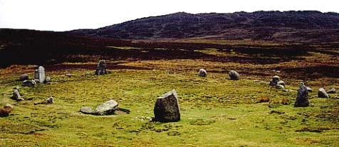
Moel ty Uchaf commands the most stunning vista; that of the Dee and Alwen Valleys to the north and north-east, and the edge of the Cambrian Mountains to the west and north-west, hills that continue in curving serried ranks to the far horizon. Behind, to the south, the view is of bare hilltop, a small copse, and masses of sky.
By now, sunlight was kissing the top of a distant hill, and pale gold light bathed everything, bringing alive its form and texture. Silence was all-consuming, the stillness of the air total and magical. The stones glowed under a vast sky. Below, Denbighshire stretched for miles. Down in the towns and vales, lives pressed on; inside the stones, life was timeless. We did not speak. Boots brushed over scrubby turf. Birds called out inside the copse. A whisper of cobweb ran delicately from a stone to a blade of grass. Caught in a breath of wind, it quivered silently, shimmering like molten gold. Everything was glorious, and very, very beautiful.
This is a stunning site; set in magnificent scenery, relatively diminutive, yet equally as magnificent for its completeness. It is quite easy to believe that the original builders abandoned it a few hundred years ago, let alone 4,000 years ago.
We visited on a classically beautiful late winter afternoon, and were bewitched. The peace of this cosy circle is deeply regenerating; its effect has continued on in me for days. Do visit, and prepare to be transported.
Tweet
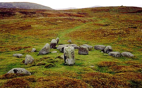
It was hard to take our leave of this place, but sunset was growing closer, and there were two other sites to view before nightfall. Happily, they were both in close proximity to Moel ty Uchaf, so returning to the car (the dogs made it clear that they weren't speaking), we headed back down to the Dee Valley, and a few minutes later, arrived in a lane bordering the field which is home to Branas Uchaf.
Parking under a wooded hillside opposite Branas Uchaf as pinky-gold light blossomed at the far end of the valley, I was pleased to see a handy stile had been built into the fence. The structure was too far from the road for my camera (a natty little digital, kindly given to me by Moth and Jane), to cope with the distance. Hopping over, I made my way across the field, and took a stroll round the whole of the mound before climbing onto it for a better look.
This circle of recumbent stones is quite lovely, and lies right next to a smart farmhouse (how is it these Welsh folk get to have such antiquities in their gardens?! See Fairy Oak Round Barrow). Some of the stones have been robbed, but nonetheless, an idea of the commanding nature of the place remains. Fab mountain views are to be had on all sides. Pretty.
A thousand years or so older than Moel ty Uchaf, Branas Uchaf is a battered and incomplete chambered round cairn. The mound itself appears to have sunk somewhat, and the chamber has been raided for stone over the years. The most impressive feature is a couple of large uprights, surrounded by a few other tumbled stones. Two lovely trees grow out of the mound.
The manner in which the stones have fallen suggest, at the briefest of glances, that something of a chamber might remain – but sadly, this not the case. However, something put me in mind of Wayland's Smithy and The Hoar Stone (at Enstone. I don't know why, because there isn't really any resemblance to either; perhaps it just felt the same. As I looked around, a loud and heart-achingly exquisite thrush's song broke the silence. Pouring mellifluously from the wood above the field, echoing like fluid, honeyed gold, its purity was breath-taking. It was that which made Branas Uchaf for me. The sense of timelessness and the sheer number of millennia which have passed since it was first constructed swept over me. Had the ancients interred their dead here, spent time with their ancestors in the stillness of the beautiful river valley, their ruminations broken only by the richness of bird song? Not for the first time the sense of ages separating us evaporated, and whatever the culture previously, a powerful sense of universe and cosmos prevailed. The burial chamber still stands proudly in its field, despite efforts to tear it apart, testament to that wholeness. I returned to Kate deeply satisfied, and was rather pleased to discover her reading The Modern Antiquarian, its orange cover glowing like the deepening sunset.
Farmhouse Rock
Although the light was fading fast, there was just enough time left to squeeze in a quick look at Tyfos cairn circle. This is close to the road, in a field adjacent to Tyfos farmhouse. Although it is possible to look through the hedge, more joy is to be had by enquiring politely at the farm for proper access; the two gentlemen we spoke to were more than happy for us to have a look.
Evidently Moel ty Uchaf's hilltop is visible from Tyfos, but I was unaware of this, although the thought had crossed my mind. Annoyingly, therefore, I wasn't too sure where to look to see if the stones could be spotted. Relying on small printouts from the excellent Ordnance Survey website (due to a lack of OS Explorer 255), I was unable to work out the precise positions. Nonetheless, I suspect Moel ty Uchaf's stones are unlikely to be seen from the bottom of the Dee floodplain, but do correct me if I am wrong.
Tyfos is a large cairn, with a big circle of recumbent megaliths atop the flattened mound. It appears to have been raided for stones, as there are a few gaps. One stone has clearly split in two; I wondered if this was the result of modern man's interference since it was positioned, or just the effects of the elements. It seemed slightly odd to have a stone circle on such a low-lying tract of land; mountains can be viewed on all sides, with the best views spreading east to west.
Due to fading light, there wasn't much time to hang around, and I tried to get some photos of stones backlit with pinkening sky. The colour and texture of the stones definitely put me in mind of Arbor Low, the only other recumbent stone circle I can recall visiting. This was more a stubby and megarakky site, really, so after Kate had amused us both with comical Green Man impressions through a hole in a nearby hedge, we left the last site of the day. Heading home for some real ale, watching a perfect sunset ending a perfect day, and singing along joyfully to Maroon 5's 'Songs About Jane', we both felt very glorious and very beautiful indeed.
|
A Wee Dram & Summer Memories
A Jolly November Evening
'Season of mists and mellow fruitfulness', wrote Keats. He conveniently forgot about the driving rain, dank air and leaden skies that typify this time of year. Outside it is a cold, wet, and miserable November night – therefore a suitable time to sit back and recall a particularly hot and sunny day at the height of summer. So, while soggy leaves blow around in the gusting rain and murky darkness, I'll make myself cosy with slippers and a steaming mug of cocoa - sod that, glass of Ardbeg and Belgian chocolates - and recount a day trip to the delightful sites of Dyffryn Ardudwy and Caer-Dyni.
What A Pair Of Stunnas!
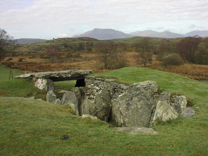
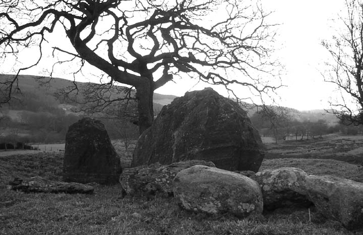
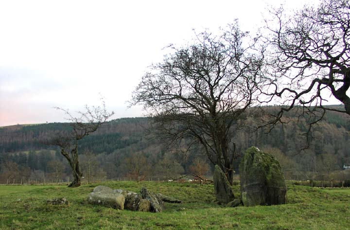
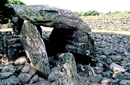
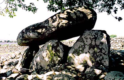
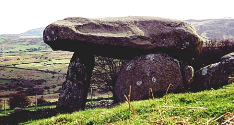
The arresting Kate and I visited Dyffryn Ardudwy back in July, on the first decent summer's day after two weeks of wet and dismal weather. We were ready for sun, sea and sand, so set off eagerly to drive through Snowdonia, and head for the glorious coastline of north-west Wales. I was keen to visit Dyffryn Ardudwy after seeing photographs of it in several of my megalithic books; and I was not disappointed when we arrived at lunchtime. As we approached the dolmens up a narrow track (after realising they were hidden behind a Victorian village school and masses of gorse bushes), the midday sun beat down out of a brilliant blue sky and puffy white clouds drifted overhead. Below us, Barmouth Bay shimmered and sparkled in the blazing sun, whilst to the north, the misty blue mountains of the Lleyn Penninsula rose out of the cyan ocean.
Our first view of the site from its small gateway was enchanting – two beautiful cromlechs stood in the shade of a magnificent oak tree, as sunshine bounced dazzlingly from the wide sea of smooth-faced stones which surrounded them on all sides. The tree towered over them in sentinel-like fashion, and at the same time contrasting wonderfully with the expanse of glaring rock. These dolmens are all that remain of a once huge longbarrow. The smaller of the two formed the initial construction, and is a very dinky portal dolmen, closed off on all sides. The whole barrow must have been a deeply impressive structure, and originally would have commanded the most inspiring views over Barmouth Bay, views now impeded by buildings and trees.
Must Try Harder
As I took photographs, Kate explored the larger of the two dolmens, and discovered the burnt remains of someone's homework inside the chamber. Clearly, Geography was not a favourite subject, as the charred papers revealed themselves to be a basic test on significant places in the world. Nonetheless, and reassuringly for us, our arsonist understood that Stonehenge is a stone circle on Salisbury Plain; but not that the Magna Carta was signed at Runnymede, selecting 'Fort Knox' instead from the multiple choice questions. Not sure if the homework was incinerated before or after marking.
The dolmen has been repaired in a rather heavy-handed manner, with the pile of bricks supporting the capstone on its southern side looking more like a 1960's style exterior stone chimney. More of this chimney work can be seen on the northern side. Yick. The capstone itself though, is huge and beautiful, sweeping up aerodynamically at the SW corner, whilst in the opposite NE corner it curves down into a shapely overhang. A truly fabulous piece of stone – the engineers who built this structure must have been thrilled when they freed it from the ground or rock face.
Inside it is a wonderfully quiet and shady place, beautifully proportioned and ideal for escaping the heat of the day. It also has that unmistakable feel of someone's den. How cool to have such a place right behind your school; I would hope whoever hangs out in it now at the age of nine will be contributing to TMA in a few years' time - hopefully, having such a thing to grow up with will spark an appreciative passion in someone's breast, as well as sparking a Swan Vesta. After all, it is the perfect spot to commit one's homework to the flames.
Small, But Perfectly Formed
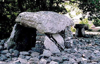
The smaller, and for my money, more endearing, portal dolmen is very similar in size, design and structure as the enchanting Maen-y-Bardd. Sitting against it while making notes, I could sense an air of finality, of resting place, and of great calm. Perhaps it was because unlike Maen-y-Bardd, the entrance had been neatly sealed with a large rounded boulder, although it was possible to look inside through the gaps in the uprights. Yet this felt like an act of observation which was somehow slightly voyeuristic, intrusive, and sacrilegious, a bit like peering into a broken tomb in a churchyard. Which is exactly what it is, of course; 5,000 years has diffused the sanctity of many of these places – now they are features of the landscape, rather than sacred resting places where rite and ritual hold sway over allcomers.
Stepping out of the stone sea, Kate and I sat under the shade of the oak, and picnicked on samosas, brie and crackers, sipping Kronenbourg 1664, and spending a long time in silent contemplation of these alluring dolmens, whilst listening to gorse seed-pods popping in the heat.
Pictures Speak Louder Than Words
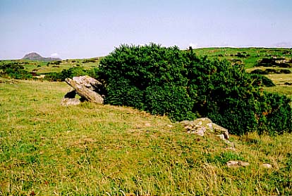
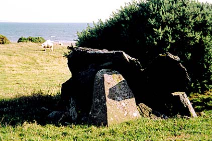
Further up the road towards Criccieth lies the broken and ruinous dolmen of Caer-Dyni. I didn't know what to expect from this site, and was rather disappointed to see such an insignificant and busted up pile of stone in a large sheep field. I asked the farmer for permission to go into the field and take some photos, and it was as I made my way nearer to the stones that I began to feel a tangible difference towards them. The remains of this barrow lie under a large gorse bush in the middle of a craggy, rolling sheep field that meets the fabulous and empty sands of Criccieth Beach. Although there was very little time to stop and take it all in, I felt very much that although broken, it was still inherently part of the whole landscape, singing with the earth's vibe – testament to the ancient builders, who clearly understood the power of the place.
The view from the footpath gives a greater sense of how it must have looked in its hey-day – the surrounding countryside of rugged mountains, golden beaches and breaking waves on the northern-most part of Cardigan Bay are breathtaking.
|
Penmaenmawr - Promising, Perplexing, Prodigious
A Passion Indulged
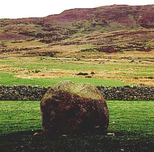
When we first met, I cautiously revealed my love of oolitic limestone and other such rocks to the arresting Kate, concerned she would reject me as some weird anorak. Happily, she has a broad experience of folk, so far from being unnerved by my eccentric hobby, promptly offered to take me anywhere I wanted in North Wales. Which was an extraordinarily generous, if little foolhardy, gesture. "And you'll have to see The Druid's Circle" she told me, "It's fantastic!". Six months later, we were off to Penmaenmawr to see not only The Druid's Circle, but a medley of megalithic sites. At the time, it all looked very simple and straightforward – especially as Kate had produced a 1:25,000 OS map which I remembered to take out into the field.
Driving up the steep 'Mountain Lane', which leads onto the side of Foel Lus, we arrived at incongruous twin pillars which signify the end of the road. I almost expected some extras from Jason & The Argonauts to coming running down the grassy footpath, chased by sword-wielding skeletons. The pillars are in fact a Victorian monument to mark Queen Victoria's Golden Jubilee of 1887, and the footpath round Foel Lus is known as 'Jubilee Walk'. We wisely picnicked there prior to starting the long footslog along Ffridd Wanc (intriguing name) and onto Cefn Coch and Moelfre. Looking up at the imposing mountaintops, we could easily see a few of The Druid's Circle stones standing out against the changing sky; with the wide expanse of Conwy Bay to our right, and the drop down to Penmaenmawr below, they already seemed pretty inspirational.
We set off along a rocky track on a very steep hill. "Is it true that Welsh sheep have two legs longer than the other?", I asked Kate. "Is it heck!" she replied indignantly; but then we saw three sheep sat below us – on a slope so steep, all of them had a couple of long legs stuck out as anti-slip props. I sincerely hoped we weren't going to have to scramble up slopes of that nature.
There's Druids In Them Thar Hills . . .
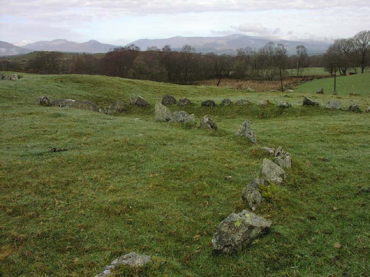
Fortunately, we didn't, and soon we arrived at the first stone circle on the map – Red Farm. I was expecting a fully-formed circle, but it was Kate who correctly identified the gently curving arc of four short stones as the visible remains of a broken circle. Shame, really, as it had probably been very impressive and reasonably sizeable. I contemplated nipping over the gate into the field to have a closer look, but as it is very close to the farmhouse itself, thought better of a quick trespass on this occasion. I did manage to balance on a rock by the wall and fire off a couple of pictures with my long lens, so hopefully, they'll be useful.
A few yards along, opposite the farmhouse, stood a huge, wide, curvaceous boulder which appeared to be very much a standing stone – although it wasn't marked on the map. (Or didn't seem to be – squinting hard at the map now, I can just see it next to the green diamond for the North Wales Path, right by the farmhouse). I notice that it is included under the Red Farm page on TMA as Bryn Derwydd, which is the name of the farmhouse as far as I can tell. Interestingly, Bryn Derwydd means Druid's Hill. It certainly doesn't mean Red Farm – that's Fferm Coch. Does this area on the map called Bryn Derwydd allude to the hike up to The Druid's Circle, or to the fact that both the Bryn Derwydd Standing Stone and Red Farm Stone Circle look across to the mountainside of Cefn Maen Amor, and the striking boulders of Cefn Maen Amor Stone Circle?
Blink, and you'll miss 'em. Four stones are all that remain of this once proud circle, judging by the survivors. They are in a field not far from Bryn Derwydd farmhouse, so I wouldn't advise brazen trespassing.
They look quite pretty, nonetheless, and by balancing on rocks at the side of the drystone wall bounding the field, it is possible to have a good look at them as they sit in a graceful curving line.
Especially intriguing is their position in relationship to Cefn Maen Amor circle, which can been seen on the summit of Cefn Maen Amor mountain directly behind them on the eastern horizon . . .
Further along, there is a huge standing stone right outside the farmhouse, the Bryn Derwydd Standing Stone. It's an impressive erection, and like the remains of Red Farm, looks towards Cefn Maen Amor.
It was clear we were entering a deeply sacred and important landscape, and I wondered whether these sites could be used in conjunction. It would be easy to watch someone performing a ritual suitably dramatically (to stand out clearly against the skyline), high on Cefn Maen Amor – would it be a ritual mirrored by a lesser incumbent in the circle far below?
This is clearly an important and impressive site - and the views it commands must be stupendous. On this occasion, we saw it from the Red Farm circle; yet the size of the boulders that form it are huge, gazing down magisterially from their lofty summit, a significant sight for miles around.
Footpaths circle the whole of the mountain. To reach the peak, the footpath crossing the southwestern side is probably the best choice, but it will still necessitate a hearty stroll across the mountaintop on unmarked land.
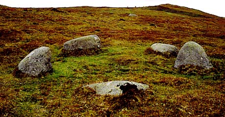
Intrigued, we carried on past some dear little lambs, and walked up the hillside until we came across the next stop on our tour – Circle 275. What a sweetie! A delightful little five stone circle, reputedly the smallest in Britain. It sits there, cute and lovely, a few hundred yards from The Druid's Circle, and just IS.
Small, but perfectly formed. Very endearing, and evidently the smallet circle in the British Isles. I can well believe it. Definitely worth a look when exploring the Penmaenmawr area.
I would have dallied longer, but Kate was urging me on as clouds were gathering over the enticing stones further ahead, and photographic light was diminishing rapidly.
Nipping over a mountain nant, I executed an enthusiastic and rapid scramble towards the big circle, which was standing out against the increasingly grey cumulonimbus. At the same time, a skylark suddenly flew heavenwards from the centre of the stones, singing beautifully. The silhouette of bird and stone was magical. But it was merely a hors-d'oeuvres for the majestic, spell-binding scene that opened out as we approached.
Powerful! Dramatic! Gripping!
Quite frankly, I didn't know where to look. The landscape was vast - on the left one huge broad sweep of bowl-shaped moorland led the eye up into the ridges and crests of larger mountains; to the right the fields dropped away steeply to the ocean and equally impressive vistas. Conwy Bay stretched for miles out into the Irish Sea, and before us lay the mouth of the Menai Straits and the eastern edges of Ynys Môn - Anglesey. It was all one potent, overpowering mix of space. The expanses of sea, sky and mountain were tangible as separate elements, yet unified as one. Truly a sacred landscape.
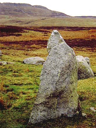
The amount of cairns and circles scattered all about served to underline this fact, but before I could explore further, I wanted to appreciate The Druid's Circle. This impressive ring of thirty odd stones is sited quite unusually, I thought, given the location. To the immediate north of the circle is a large mound of earth from which it possible to look down on the stones; yet from within the circle, this mound blocks all view of the beautiful bay, which is clearly visible if you take a few steps to the east or west.
Too concerned with taking photos in fading light to look at all the stones (I ought to have given more attention to the natural curving 'shelf' on one of the stones, the 'Stone of Sacrifice', as it quite interesting. Lurid legend has it this was the resting place for babies sacrificially slain within the circle), but I was taken with a stone that Kate pointed out to me as looking like a monastic or druidic figure. It was quite eerie, and approached from a specific angle, looked very much as if it might turn and confront a passer-by. I was later to discover this was the 'Deity Stone' mentioned in stubob's folklore notes. Certainly does appear as if it could give someone a hefty clout.
A splendid place. Certainly one to sit and contemplate in for a while, enveloped by the sea, sky, and land which entirely surround the observer on all sides. A large ring, with some significant stones; most spooky being the one that has the form of a white-robed druid.
The location of this circle is intriguing; despite stunning views over Conwy Bay to the north, it has been sited behind a steep mound, thus blocking the view of the sea. Or has the mound been built in front of the circle? There is no doubt that the mound, whatever its origins, is an excellent observation post for anything that might be taking place in the sacred space below.
Also interesting is the proximity of Circle 275 and Circle 278, which flank this larger circle a few hundred yards away on either side. Were they used in conjunction with ceremonies inside the Druid's Circle?
This is a lovely place, and well worth an extended visit with a decent picnic over the course of an afternoon. You might also want to take along a couple of megalithic guidebooks and assorted information to explore the rest of the nearby moorland, as it is littered with sites of interest, some easy to find, some not so easy.
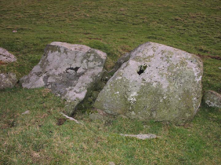
Circles Of Confusion
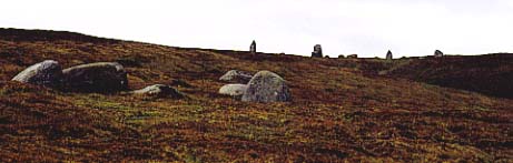
The wind had begun to whip into a chilly breeze, and solid rain clouds were on their way over from Anglesey, so I quickly set off to have a look at Circle 278, which is listed as a ring cairn. Here, two charming, yet flummoxing, circles lie only a few metres apart within the same grid reference. One is a wide circle constructed of stones several feet deep, which I took to be the ring cairn (subsequent research would suggest this is the case), and the other is an attractive but disordered collection of large stones*, which clearly had a set design sometime ago, but now seem very muddled. It was this tumbled mass that captured my attention for the short time available, although I really only had opportunity to fire off a few pictures.
This a confusing one. There is a ring cairn which I believe to be Circle 278 just beyond a far more interesting jumble of stones*, which appear to have been moved about somewhat. There is clearly confusion over the name of this mix of stone; please refer to my weblog for a more in-depth discussion.
It's all very lovely, nonetheless!
*Edit by TMA Ed: the "jumble of stones" is now generally thought to be Monument 280".
This structure seems to be the source of much debate as to whether it is Circle 278 or not. Personally, I don't believe that it is Circle 278; trying to find out more information since our visit, I discovered that it is listed on the Megalithic Portal as 'Moelfre Stone Row'.* Well, I am a tad dubious about this also, for three reasons: 1) it looks far more like a badly broken stone circle than a stone row to me; 2) it lies almost the same distance to the west from The Druid's Circle as Circle 275 does to the east. Each of these smaller circles are visible from both the interior and exterior of The Druid's Circle, and especially from its northern mound; 3) according to the map, this confused collection of stones does not lie on Moelfre Mountain, but on Cefn Côch.
The fact that these circles all lie within site of each other echo the pattern further down the valley with Red Farm and Cefn Maen Amor Circles. Could Circle 275 and The Jumbled Heap have had a similar purpose to side-chapels in a modern day church, acting as lesser centres for worship compared to the large Druid's Circle, yet still being contained within its power, or the power it focuses from the surrounding landscape? Would they have been used in conjunction with the larger circle?
For purpose of clarity, it might be an idea to name this jumble 'Penmaenmawr Stone Circle', which is what the RCAHMW database offers for the grid reference SH722746. (I realise it also offers about 11 variants for the same site on the same co-ordinates, e.g. Penmaenmawr Stone Circle C,D,E,F,G,H,I,J,K,L,M), but as there clearly weren't 11 other obvious sites on that spot, I would humbly suggest that this might be a useful name. However, and most irritatingly, the RCAHMW also suggest the same name for Circle 275, which is already additionally named as such on TMA. Therefore, I will humbly stick my neck out and propose this enigmatic feature be known as Cefn Coch Stone Circle as a suitable solution for the time being. Sadly, I do not own a GPS gizmo, and had not seen greywether's forum posts on the subject – otherwise, I would have been more assiduous in paying attention to its precise location with regard to other landmarks; hopefully my photos will reveal information of use. [*Edit: this is (now generally thought to be) Monument 280 - TMA Ed.]
But enough of this – the clouds were now stacking up darkly, and we were in danger of a wetting, so we decided to leave this fantastic place, and head off for the next sites on the list – Caer Bach, Maen-y-Bardd and two standing stones.
Is She Or Isn't She?
In the event, by the time we returned to the car, tired ankles and distracted navigating cut out Caer Bach, and we headed directly for Maen-y-Bardd. The map gave every impression of a nice easy road to drive along, where it would appear we could merely pull up, hop out, and enjoy the site without too much strenuous walking. Hah! I forgot this is Wales, and what is on the map does not always follow in the field.
Kate flung the solid and trusty Ford Focus up an increasingly steep, winding, narrow road, full of blind corners on a 1:3 gradient - which was fun, if not a little nerve-racking. The map suggested that the next megalithic port of call was only a few hundred yards along the road after a youth hostel at a place called Rhiw. In the event, the road abruptly stopped at the youth hostel, turning in to a rutted, rocky track navigable only with a rugged 4x4. We were going to have to do it the neolithic way after all.
Leaving the car outside the youth hostel, we walked up the track, enjoying the just-budding green leaves on the trees, and the remains of bluebells alongside clumps of wood anemone and lesser celandine. As we walked further uphill, a pretty little nant full of mossy stones and trees burbled along below the path, whilst above us, we could see into fields of sheep. We also spotted a jolly handsome black neck cock pheasant in the steeply banked hedgerow. He eyed us warily, the sun glinting on his fabulously coloured purple and red feathers, giving them the texture of a richly shot silk or taffeta which wouldn't haven't looked out of place in Harvey Nicks. . . dahling.
We carried on in the beautifully warm sunshine, until the fields opened up, spreading away into craggy mountainside, and ahead in the field nearest the road stood a perpendicular stone. I had noticed that the 1:25,000 map said that there are two standing stones at approximately this point – but where was the other? Looking around, the nearest thing in relation to the picture on the map was a very solid drystone wall. Further scrutiny revealed another upright, though slightly leaning stone - much the same height as the single one in the field - built in to the wall. This had to be the pair that the map mentioned.
But I was puzzled; there seemed to be no reference to them on TMA in relation to Maen-y-Bardd, which is odd, as the dolmen is only a hundred or so yards away. The single one certainly had to be a standing stone, of that I was certain – but I wasn't quite so sure of her sister. Looking on the RCAHMW website, I see that one is listed as a 'Standing Stone (Alleged) Maen-y-Bardd', but continues to say it is prehistoric. Looks very much like a standing stone to me, so - 'is she or isn't she?'
Megatastic!
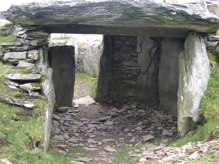
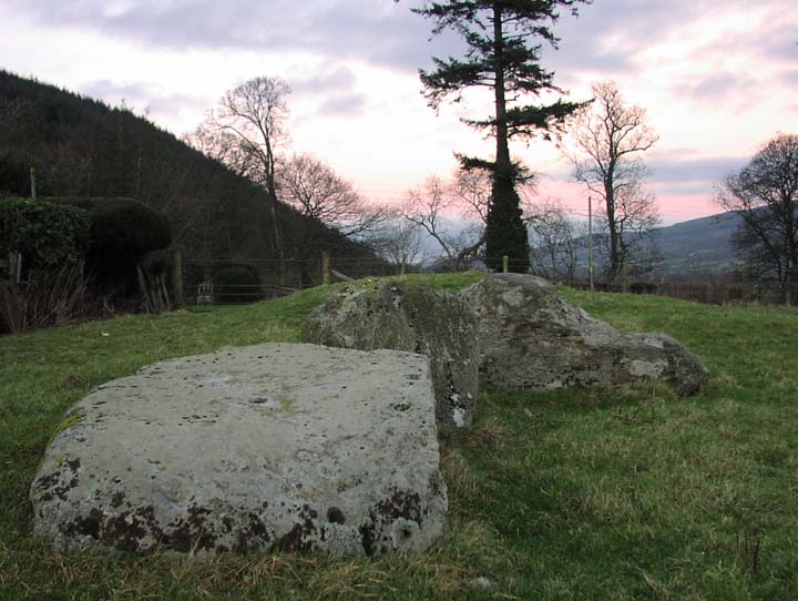
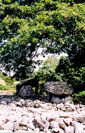
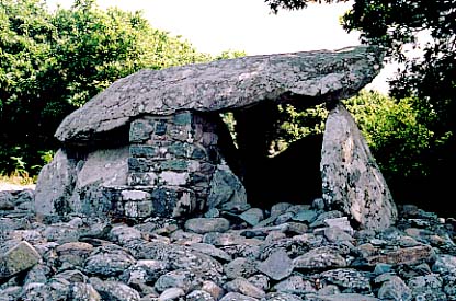
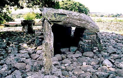
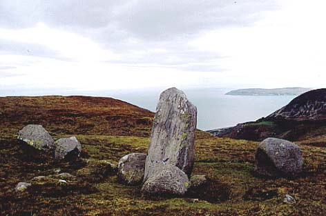
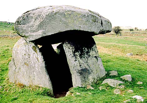
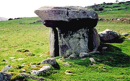
"There it is!" said Kate, pointing to the next field along from the ??standing stone. Against a blue and cloudy sky, in emerald fields scattered with crags and boulders, Maen-y-Bardd appeared to be one more lump of limestone rock protruding from the earth; but a second glance revealed a tiny and charming cromlech nestling in the landscape. We eagerly trotted up for a closer look.
What an exquisite place, and an exquisite structure. A definite one to visit, a megarak's must-see.
I said to the arresting Kate that it was a little gem, and then was put in mind of small iced biscuits. Now, I'll never be able to eat a purple-topped Iced Gem without thinking of this most divine example of dolmen building.
It is perfectly constructed in every way, and enjoys terrific views over the Conwy Valley. (See weblog for further details).
Go on. Treat yourself this summer. You won't be disappointed.
'The Poet's Stone' is a veritable delight, a joy to behold; truly a thing of beauty. Though small, it is exquisitely engineered – clearly, an accomplished craftsperson designed and erected it 5,000 years or so ago. (We suspect it was probably a woman ;o) ). I was particularly impressed with the dressing of the rock on the underside of the capstone, and the manner in which the capstone rested on the uprights. It would have been impossible to slip a sheet of paper between them, especially in the northern corner.
The front of the capstone is supported by a cleverly artistic placement of stones, such that when viewed from either side it appears to be balancing on a single slim pillar of stone. In reality, two fairly broad slabs of rock are doing the job, with the entrance between them. A triumph of design.
The chamber itself is perfectly rectangular – great care has been taken to square everything off precisely – and the atmosphere within very calm and secure. Not very high roofed, it was necessary to stoop once inside. I wanted to sit in the serenity of this chamber for a while, but the presence of young and fresh ovine ordure prevented me from doing so. Certainly didn't feel right to see sheep poo lying in such a wonderful space.
But it is the views that add to the splendour of this little beauty. Maen-y-Bardd commands the most staggeringly beautiful vistas across sand banks of the River Conwy as it wends its way to the sea, views that encompass swathes of idyllic rich Welsh countryside for miles around. Soft fertile pastures give way to woods and moorland; acres of steeply swelling hills to the east of the river; and the craggy peaks of Tal y Fan behind this most charming of dolmens. A slight haze hung in the late afternoon light, but the springtime warmth and greenery was so welcome after the murk of winter.
Kate stretched out in the sun a few feet away as I took photographs with gay abandon, and I would have been happy to spend the rest of the evening there, had we been suitably equipped with a tartan rug, warm clothing, slap-up picnic with lashings of ginger beer, and a couple of bottles of Old Peculier. But we weren't, so ruefully we left to rescue the dogs and find a pub. As we walked away, I took a final look at the magnificent scene before me.
"What a fabulous place to end up," I said to Kate thoughtfully. "I certainly wouldn't mind being laid to rest here – would you?"
"No," she replied, "That I wouldn't."
Birds sang, a buzzard kewwed, and timelessness wrapped about us.
|
O We Try . . . And How We Succeed!
Sounds Funny, Looks Fab
Oswestry. An odd-sounding market town in the depths of Shropshire, on the Welsh-English border. Back in the 13thC CE, the English would have known it as Oswaldestre (1272) and the Welsh as Croesoswald (1254). It was at the forefront of the border wars, changing hands three times between the English and Welsh - a thing of importance later on in this weblog. (The meaning of Oswestry? In English"St. Oswald's OE treo 'tree' (possibly in the sense of a 'wooden cross') ". In Welsh it was "St. Oswald's cross").
It is also the hometown of the awesome First World War poet Wilfred Owen; and having studied his work many, many years ago at school, I had been intrigued to visit the place for quite some time. It didn't let me down, and it is possible to see some absorbing memorabilia of his life and work in the Heritage Centre, including photocopies of the original Anthem For Doomed Youth. Very sobering.
But Oswestry is home to a jewel that far pre-dates the skirmishes of the Marches and senseless butchery of Flanders; that jewel being the phenomenal Old Oswestry hillfort, which beats the other two on date by about 1500-2000 years. And phenomenal is the word – I believe that this site is second only to Maiden Castle in Dorset; rightly so – it is a massive, complex, awe-inspiring structure.
The arresting Kate and I pulled up in the small car park at the foot of the western entrance on a gloriously warm and sunny spring afternoon. As it was mid-week, we were delighted to hear the happy screams of children emanating from a nearby schoolyard, and not from the hillfort itself. The sky was a deep blue, with a few wispy clouds, the sun shone forth warmly for the first time in two weeks, and before us, the huge, well defined ramparts of Old Oswestry rose up. I licked my lips with anticipation.
Unique and Unusual
A few steps into the narrow passage of the western entranceway made one realise what a daunting feat of engineering constructed this vast place. The ramparts are immense, yet initially look like a roughly doled out puddingy mass, certainly to the west. But a closer look reveals seven lines of ramparts, and – uniquely – eight to ten huge pits, which in diagrams appear as if a gigantic hand has crimped the edge of the hillfort, much like a pastry pie crust. Aerial views give a clear depiction of this most unusual feature of any hillfort; but from the ground it appears to be more of an obstruction to anyone wishing to attack the place.
In fact, it would appear that nobody is entirely certain what these pits were designed for – whether they were water tanks, quarries, or extra fortifications. Could they have been used to trap any invaders? Were they animal pens? Animal pens seem like a good idea to me – and as Kate said, they probably have some very simple and straightforward explanation of that nature. As they are adjacent to the largest entrance, presumably they must have had something to do with callers (pleasant or otherwise), or the transactions of goods. Nowadays, two of these pits sustain well-established ponds, complete with pond skaters or possibly whirligig beetles. (It was hard to see without getting covered in stinking mud). A third pit is home to another pond which seems to be silting up – nonetheless, it has a fine growth of bulrushes. Bizarre.
English Heritage have kindly provided five fairly unobtrusive signboards and a tour round the hillfort which is quite helpful, so after moving along the ever-narrowing western entrance passage, we followed the informative signs, and climbed the stile that leads up onto the top rampart.
Sights For Sore Eyes
Well. The views were wonderfully pretty. To the west we were treated to a fabulous scene of gently undulating hedged fields with spinneys and copses, emerald pastures that were home to cows and sheep, and a blue, blue sky that stretched for miles to the soft mountains over the border in Wales. Away to the north was the Cheshire plain, and this flat territory also stretched round to vanish into the eastern horizon. The southern edge offered a charming view over Oswestry itself, and nearer, what remains of the rampart of Wat's Dyke (more later).
We rested for a picnic overlooking this idyllic English scene, complete with manor house of the style seen in Knight Frank adverts. After a fine repast, I left Kate sleeping in the wonderfully warm sun, and set off to walk the ramparts. The centre of the hillfort is fenced off, although there seems to be a rough track leading into the middle from the northern end. During the First World War, Canadian troops were allowed on to the top to play at digging trenches and blowing up things; in the Second World War it was apparently ploughed. By all accounts it had been smothered in trees and undergrowth for some considerable time, sounding a dark and forbidding place; quite a contrast to the open grassland of today, although several small shrubs are doing well amidst the ramparts.
We had been blessed with a fabulous day for a our visit, even so, I couldn't help feel slightly sorry we hadn't made it a month before - every side of the structure would have been a wonderful shade of deep blue, due to the unending carpet of bluebells that covered the ground. They were just about over, so the blue wasn't as brilliant as it might have been, but occasional splashes of white wood anemone brightened the bracken and grass. Old Oswestry was teeming with wildlife, with warblers and larks singing all around, and kestrels hunting on the western side. Butterflies flitted across the grasses in tumbling groups, and all in all, it was a thoroughly pleasant experience.
Tramping along the eastern edge, the ramparts literally towered above me, and it took a good twenty minutes to do a full circuit. I was reminded very much of the British Camp in the Malverns, which I visited as a child.
700BCE And All That
After doing another circuit for the hell of it, I took some photos and explored the pits. The confusing nature of this part of the hillfort put me in mind of Maiden Castle, with its disorienting and intimidating entry earthworks. (Minus the ponds). Background reading would suggest that Old Oswestry was probably as important as Maiden Castle. Possibly home to the Cornovii tribe, it is suggested the fort had been settled as early as 700BCE, although it would have been unfortified at this time. The ramparts were built in three phases, with the curious pits built in the final phase. By the time of the Roman occupation, it was deserted; although the 10thC CE Welsh Annals tell us that in 658CE it was the site of the final stand of the Welsh king Cynddylan, bested in battle by the Anglo-Saxon king Oswy. Cynddylan was reputedly the last descendent of the legendary King Arthur to rule in Shropshire, but as these chronicles are a bit hit-and-miss, this should be taken with a pinch of salt. In Welsh, Old Oswestry was probably known as Yr Hên Dinas,– the Old City; a more romantic tale has it as Caer Ogyrfan, the City of Gogyrfan. Some sources suggest that Gogyrfan was the father of Guinevere, the fatal temptress of Arthurian legend.
Whatever the ancient name of this fabulous place was, we know that it was still of immense defensive importance in medieval times, being incorporated into Wat's Dyke, a vast defensive earthwork running 65km along the Welsh-English border, probably built around the 7th or 8thC CE.
This is a fascinating and absorbing place, with a rich history and intriguing questions. I cannot recommend it highly enough, especially for a picnic on a beautiful spring day, and hope that you will enjoy it as much as we did; I can see this becoming an entirely suitable sop to the lack of access to Uffington Castle, due to my recent move to North Wales!
P.S. The bit about 'O We Try'? Some wag had once masked out the s's on a sign for the town . . .
What a corker! This is a huge, overwhelming, complex and thoroughly unusual hillfort. Massive ramparts tower upwards, on the eastern side numbering five banks, but on the west increasing to seven. Even more intriguingly, the western side has five massive pits built into the defences, a construction totally unique in hillfort design.
The history is rich (see weblog for full run-down), the views magnificent, the atmosphere lovely and unspoilt. An absolute must-see for any self-respecting hillfort fan, or those requiring a jolly splendid picnic.
|
|
"Out of the strong came forth sweetness"
---------------------------------
Treaclechops died on 4 January 2007 after a three-month battle with cancer. She was 38.
---------------------------------
|