Exquisite location... looking from Tal-y-Fan.
Image credit: Robert Gladstone
Exquisite location... looking from Tal-y-Fan.

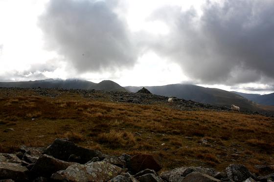
Upon the western defences, looking very approx south(ish) to the high summits of Y Carneddau.


Towards the eastern flank of Tal-y-Fan...

Western flank, looking very approx north

Towards Dyffryn Conwy... the river nearing the end of its short, sinuous journey from inception upon The Migneint.

The wondrous Pen y Gaer is just in frame, extreme right.

The defences don’t appear that substantial from altitude... but are actually not bad at all, to be fair. Pen Llithrig-y-Wrach can be seen upon the skyline.

It’s taken me some 30 years to finally get around to doing the full west-east traverse of Tal-y-Fan and so get here... but worth the wait. The hillfort is just to the left of the drystone wall.

Caer Bach just below centre, merges with the hill side almost seamlessly.

Toward the hillfort from Tal-y-Fan, struggling to cope with severe gale force winds. Serves me right for going camping in the tail end of a hurricane. The Afon Conwy completes its journey from the Migneint uplands to the sea in a stately meander beyond.

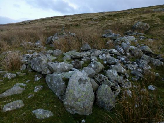
Half a stone/hut circle half destroyed by the building of the path. Tut.

Pointing the way to Moel Eilio or maybe Pen y Gadair


Looking over the forts interior to the top of Tal y Fan

Hut circle 30 meters SW of fort, looking S.E

Hut circle 30 meters SW of fort, looking through the entrance.

The nearby well at Llangelynin church, it could have been used by the forts of Caer Bach or Cerrig y Ddinas which is closer.

Stone ramparts on the east side of the fort.

Looking along the SW ditch, with Tal-y-Fan behind.

Looking northeast over the Conwy Valley.

The stone-lined interior of the unrecorded structure. This is clearly “constructed”, not natural.

Unrecorded megalithic structure near Caer Bach. Ideas anyone?

Approaching Caer Bach from the SW.

interior displaced defensive stones.

Westerly defensive ditch.

Centre of fort.

Looking to the North with defensive wall.

Looking East with defensive wall.


Looking north-westish from in the ditch

Looking south from the ditch on the western side of the fort

You can see the hill fort as a small oval shape this side of the wall. House platforms can be seen beyond to the right.
Taken from the eastern slopes of Tal y Fan.

The anomalous recumbent
The surprisingly powerful little hillfort approached from Tal-y-Fan..
Climbing directly up the grassy slopes of Tal y Fan’s southern flank, we pass a ruined homestead and regain a proper path. The map shows some cairns here, but we fail to see anything obvious. [Postie’s subsequent visit shows we weren’t missing much.]
Caer Bach now rises in front of us, flat-topped and dotted with gorse. Just before we get there, we come across a very strange “structure”, consisting of a huge oval boulder apparently placed over some supporting stones to form a small open-fronted chamber, which appears to have been lined with smaller stones. It looks constructed rather than natural, but what it is we have no idea. There’s so much going on in this area that it’s difficult not to imagine it having some significance.
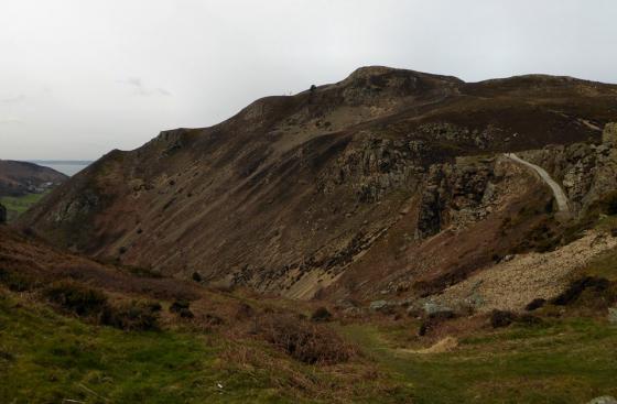
Tal-y-Fan’s summit, crossed by a typically improbable drystone wall, now looms directly above us. It looks almost within touching distance from here, but it’s not on the menu today. Instead we head for the fort. The earthworks aren’t the most impressive, but as with every other place we’ve been today the setting is superb. The views extend to Pen-y-Gaer (Caerhun) and Cerrig-y-Ddinas, so whether the occupants were friend or foe they were certainly observable. It’s a neat and compact site, feeling quite sheltered in the lea of the mountain’s flank, despite its lofty position.
I took heed of Skins advice and parked up at Llangelynin church, a pretty little church high up in the hills below Tal y Fan, reached by a thin little hair pinned road. In the corner of the church yard is a walled natural spring, perhaps used in the iron age by the inhabitants of Cerrig-y-Ddinas hill fort, though there are other wells and a couple of springs around. Some people could come just for the well, but there is a lot more up in these hills on the edge of Snowdonia, I’ve been up here a dozen times already and still keep needing to make return trips.
From the well I made my way into the next field, directly south, for in this field is a hut circle. Alas I could see nothing of it at all, not even a maybe. I didn’t spend too long looking because I’ve got a long way to go, and many sites to get to. Orienting myself from the church to the peak of Tal y Fan, I more or less walked straight to the fort of Caer Bach. North west of the fort I first came to a stone circle, (be it stone circle or hut circle or kerb cairn I do not know) well half a one the other half had gone thanks to the footpath, tut.
This is such a weird hill fort, firstly it’s not on a hill as such, of all the hill tops around they chose a slight bump of a hill. Maybe they weren’t looking to dominate the whole valley down to the Conwy river, just the immediate locale, the path going past it is i’m sure an ancient one, an important trackway through the hills, the Roman road Sarn Helen is really close by.
The fort has ditches, but up on the fort proper there are what look like old walls, big boulders joined together by smaller fist sized stones. Then there’s that big stone in the middle, aligned maybe on Moel Eilio, or maybe not.
Nearby is a strange megalithic structure, probably natural but possibly enhanced by human hands, the capstone on the chamber is too big and the chamber too small(see Sweetcheats pics) also nearby is a cairn, my next port of call, no idea what it’s like so it could be a nice suprise, or maybe not.
So much to see, and so mysterious, marvelously mysterious.
A solution to the long walk is too drive up the little lane up to the church ( there’s a small parking area for the church so park thoughtfully) then walk along up the farm track beneath the hill it rises though. keep on it till the fort appears on the right about a half a mile away. There is a house platform to the left, but little can be seen.
It’s a long walk from everywhere this one, I came from by the Cae Coch farm and menhir to the south-west. Looking at the map the fort is on the left of the footpath, but the fort and its small hill is so assimilated into it’s surroundings that I walked past it and on to the highest point around, from there I could see it quite clearly. You might be better coming from the other side after parking by the old church and spring.
It isn’t a large fort but it is in a great place overlooking the entire river valley below(presuming they utilised the two other higher hilltops nearby). The ditch is mainly on the western side and is at least 7ft from top to bottom. Inside that bank and ditch is the remains of the stone built wall just the scraps of which are left, amongst the wall rubble are some large boulders were they here already or moved into place to stregnthen the wall.
Which brings us to the strangely out of place long boulder, it must have been placed there i’m sure, it’s right in the middle of the fort and carries an air of usefullness.(if thats possible)
Small Hill fort with a large white recumbent stone in the centre.
This is a very different type of stone from that which is found in the immediate vicinity. There’s a hollow just next to the stone, possibly it was underground at some point, but I can’t see how it could be a glacial erratic, as the stratum it seems to come from is nearly at sea level, well below the height of the Tal-y-fan. So my instant response to seeing it was to think that someone had gone through a lot of bother to drag it up here. Mind, I’m no geologist and could be totally wrong about this. There are also cavalry tripping stones in the main entrance, that I am sure of.
The site has a clear view of the Conwy estuary and the Great Orme, but is still nicely tucked away from sight from the immediate locale. In retrospect, how I wish I’d tarried longer. The white stone of Caer Bach can be blamed for all of the posts I’ve clagged this website up with, it was the one that sent me looking for an online version of tma in the first place.
Coflein (thanks Kammer for bringing Coflein’s existance to my attention) says:
Small hillfort on rounded hillock, two lines of defence circle the hillock, the outer consists of an earthen bank and an external ditch. The inner defence is a heavily robbed stone wall, between 4 and 5 metres wide. The entrance ramp cuts both defences on the SE.
No mention of the strange, big, white and distinctly out-of-place stone. Nor of the chevaux-de-frise (sp?) on the NE entrance.