|
|

|
|
Coate Stone CircleStone Circle
|
|
|
|
News |
|
|
Photos https://vimeo.com/99198566 |
Posted by GnK 26th June 2014ce |
Objections to Moving FootpathsOk – I talked I bit more with some of the locals – it appears that a complaint has been filed against the archaeologists for not excavating a whole heap of prehistoric archaeology to a good enough standard> more to follow on that; However; it seems that no order was ever made to move the footpath !! - despite ground works already h... continues... |
Posted by GnK 19th June 2014ce |
Excavations near Coate/ Commonhead, 2014I travelled past Coate the other day; As part of the Development of the huge tract of land to the imediatley to the east of the stone circle, it seems that a range of prehistoric archaeology has been discovered... continues... |
Posted by GnK 22nd May 2014ce |
Fight Over!This government has a lot to answer for. Flying in the face of strong local feeling and the decision made last year by Swindon Borough Council to finally reject the development at the land surrounding Coate Water Country Park (with all its archaeological and historical associations)... continues... |
 Posted by tjj
21st March 2012ce |
Battle for Jefferies' land: How a 19th-century naturalist became a cause célèbre in WiltshireWriting in The Independent today Jack Watkins reports that - "Jefferies grew up and, until he married aged 25, lived on a tiny farm at Coate, near Swindon... continues... |
 Posted by Littlestone
5th August 2011ce Edited 5th August 2011ce |
Plans for homes at Coate rejected (again)http://www.bbc.co... continues... |
Posted by tjj 8th June 2011ce Edited 9th June 2011ce |
Coate Development - 'The battle is on again...'Was out walking locally today down Dayhouse Lane which runs alongside Coate Country Park; also the site of what remains of the Coate stone circle. Dayhouse Lane is a little bit of rural history as, apart from the stone circle, it is also often mentioned by writer Richard Jefferies... continues... |
Posted by tjj 31st December 2010ce Edited 1st January 2011ce |
Coate Water Development thrown out!Brilliant news for the people of Swindon; for admirers of Richard Jefferies; and lovers of rural England in general. The hard fought battle to save the land adjacent to Coate Water Country Park has been won ... for now anyway... continues... |
Posted by tjj 6th August 2009ce Edited 15th January 2010ce |
Coate could be the new AveburyA CONTROVERSIAL area of land in Swindon that is earmarked for a housing development could instead become Swindon's own "mini-Avebury", according to campaigners. The claim comes after ancient stones, which could be part of Swindon's Neolithic history, were unearthed at Coate... continues... |
 Posted by goffik
20th March 2009ce Edited 20th March 2009ce |
Coate development gets government go-aheadCONTROVERSIAL plans to turn fields near Coate Water into houses and a university campus have taken a huge step forward. A Government report published this week by an independent panel has given the go-ahead to the divisive development... continues... |
 Posted by juamei
2nd January 2005ce |
Images (click to view fullsize) |
|
Photographs: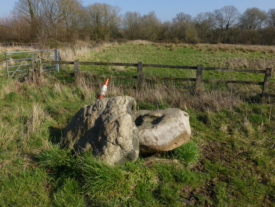
 Maps / Plans / Diagrams:
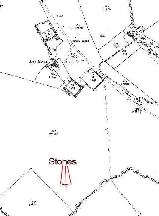
|
Fieldnotes |
|
|
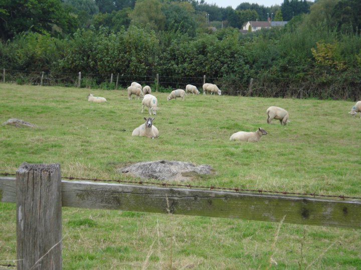
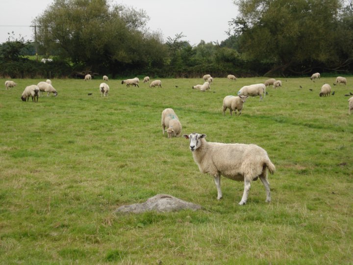
Visited 6.4.13 On the way to Peterborough and Flag Fen I took the opportunity to start our little holiday with a quick ‘look see’ at the Coate stone circle. Access is easy enough as a minor road runs directly past/through the circle. As has been previously said, 5 stumps of stones are easily visible from the road (as long as the grass is kept short) and I settled for a view from the road side. I saw little benefit in jumping over the rusty barbed wire for a closer look. What a shame this circle has not survived intact. Although I doubt the people living in the posh houses opposite would welcome the increased number of visitors that would attract! Worth a quick detour when travelling along this stretch of the M4. |
Posted by CARL 9th April 2013ce |
|
Taken from the Coate Water Country Park FB page: "Coate boasts a host of Bronze Age, Romano-British and Medieval history that spans a period of up to about 3000 years. The oldest known ancient monuments at Coate are the Neolithic Stone Circle and the Bronze age burial mound along Day House Lane. However, no less than six Stone Circles have been recorded in the Coate area linked up, in part, by avenues of large Sarsen stones. The remains of one of the stone circles probably still lies at the bottom of the lake at Coate Water whilst other ancient finds are dotted around the area that include evidence of Medieval settlements." |
Posted by tjj 28th February 2013ce |
|
I didn't check for alignments when I was there, but I suspect there may be a possibility of a line up with a 'sleeping figure' in the hill to the south. I took a picture at the time, I'll have to dig it out and check. Has anyone else noticed or mentioned this? This post appears as part of the weblog entry Wilts and Glocs Loop
|
1st May 2003ce Edited 1st May 2003ce |
|
Just thought of a little bit of info that might go down well with the subject of the Coate Stones. Not very far away from this site is a rather "exclusive" housing area near the golf course,which has large standing stones on the end of some of the closes as "punctuation points". I'm not sure if they are all "real" standing stones as one of them looks like its made of a dodgy sandstone/cement mixture and it has that strange golden colour. Might be worth investigating further to see if they are related in any way. |
Posted by neighbourofthedrude 6th January 2003ce Edited 6th January 2003ce |
|
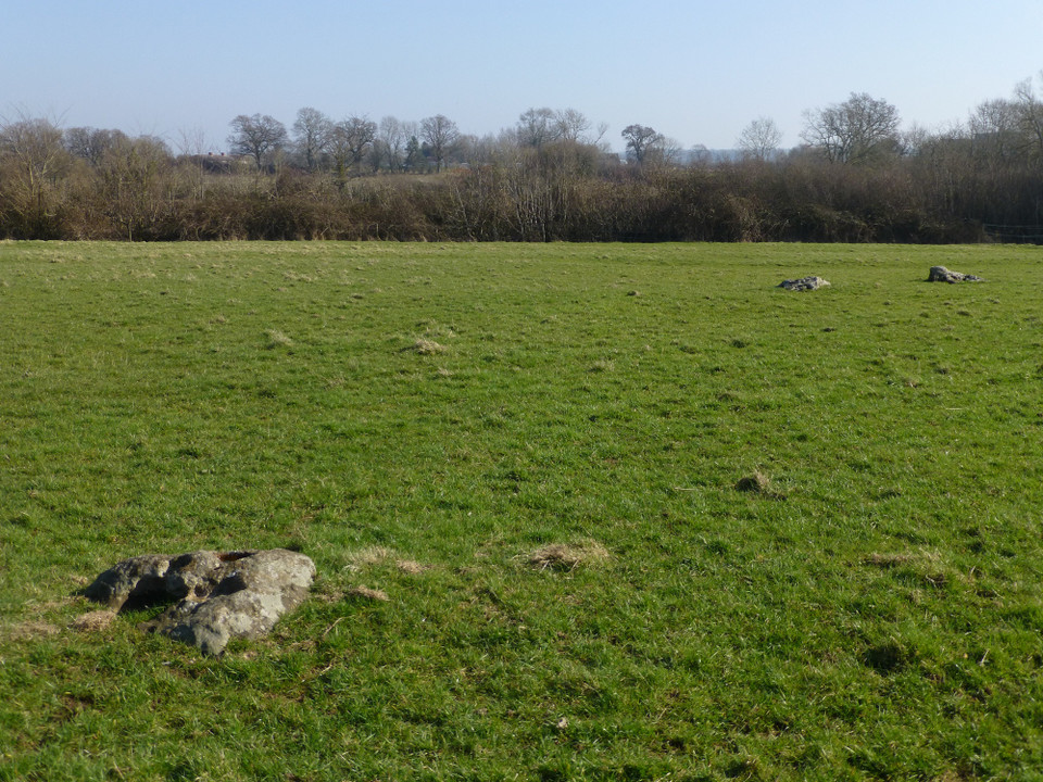
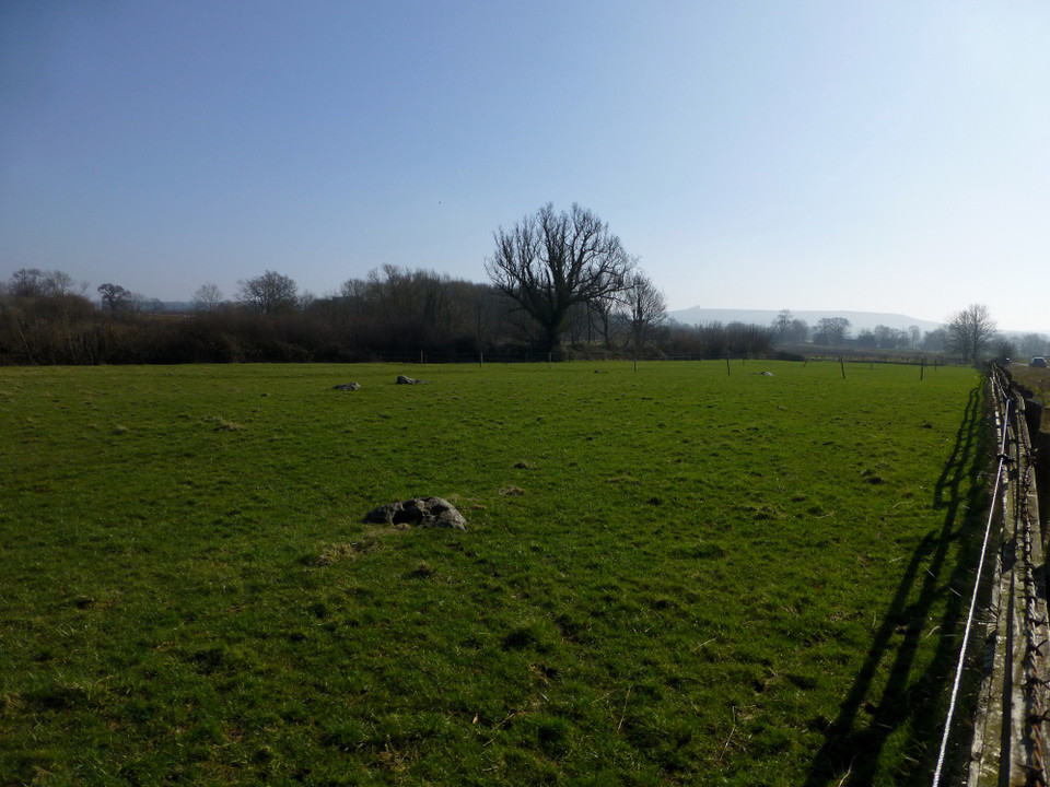
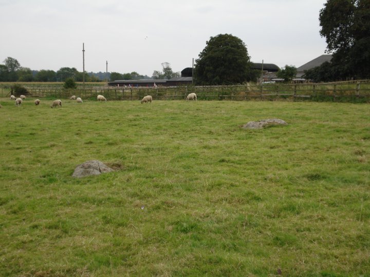
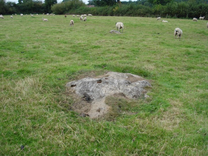
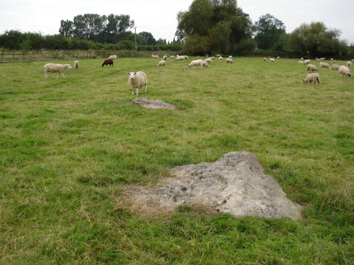
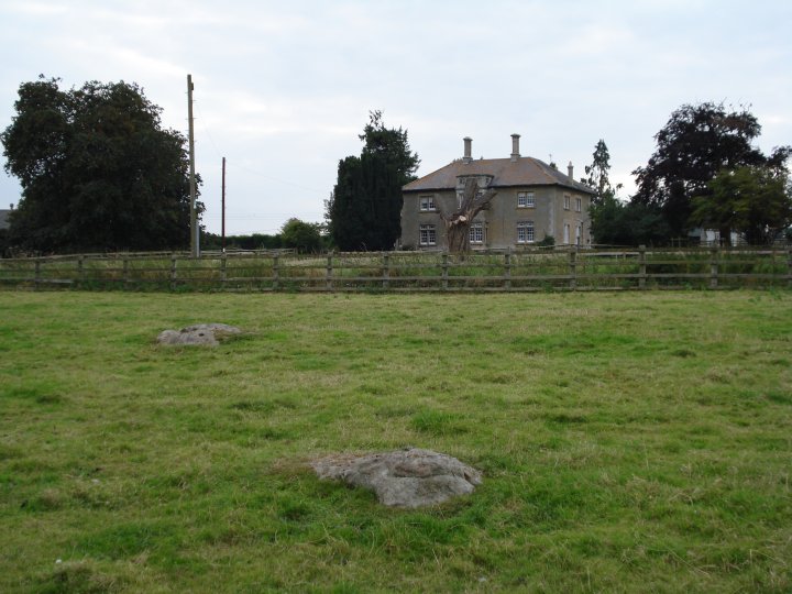
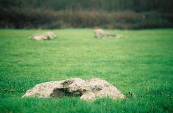
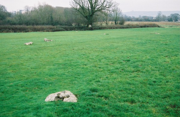
This little visited site is situated on the outskirts of Swindon. It is a runied stone circle which now consists of an arc of 5 stones. Dayhouse Lane bisects the intact remains of the circle and the vansihed half. All five stones have fallen but each is significantly bigger than those of the nearby Winterbourne Basset circle. This site was discussed on the Forum in summer 2002. Liddington Castle and the Ridgeway are clearly visible from here. It is on a direct aligment with Barbury Castle and Avebury to the south. |
2nd January 2003ce Edited 2nd January 2003ce |
Miscellaneous |
|
|
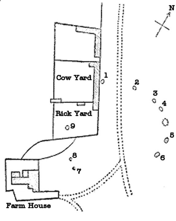
Details of site on Pastscape A stone circle located immediately north east of Day House, Coate. Visible remains of the stone circle are represented by five recumbent sarsens arranged in an approximate semi-circle in the field to the east of Day House Lane. The the west of Day House Lane a further four stones have been previously recorded. These suggest that the overall diameter on the stone circle is approximately 92 metres. Scheduled. (SU 18168240) Stone Circle (LB) (SU 18168197) Stones (TI) (1) An irregular circle of 9 recumbent stones was found by A.D. Passmore in front of Day House Farm, Coate. The stones were almost completely buried but when excavated were found to be between 5ft. and 9ft. long. Alongside Day House Lane, to the N. of the circle, are five stones which may have formed part of an avenue. To the SW of the farmhouse are three sarsens which may have been part of a stone circle. (2) Of the nine stones in the circle described by Passmore only five can still be seen. Surveyed at 1:2,500. None of the line of stones to the north of the circle can be seen. The three sarsens S.W. of the farmhouse have been destroyed by explosives, though some of the pieces remain. A further line of stones extended from SU 16098382 to SU 16178395(a). These were mentioned by Passmore but have since been removed. Local tradition says that the stones marked the site of a trackway. (3) Additional reference. (4) -------------------------------------------------------------------------------- SOURCE TEXT -------------------------------------------------------------------------------- ( 1) Ordnance Survey Map (Scale / Date) 6" Provisional 1960 ( 2) The Wiltshire archaeological and natural history magazine 27, 1893-4 Page(s)171-4 ( 3a) Annotated Record Map 25" ( 3b) Oral information, correspondence (not archived) or staff comments ( 3) Field Investigators Comments 29/08/1968 ( 4) Aubrey Burl 1976 The stone circles of the British Isles Page(s)348 ( 5) Scheduled Monument Notification 08/12/1997 |
 Posted by Chance
21st March 2012ce |
The remaining stones of this circle, which have hitherto escaped the notice of archreologists, lie immediately in front of Day House Farm, about a quarter of a mile from the village of Coate and two miles from Swindon. Notes on an undescribed Stone Circle at Coate, near Swindon. By A. D. PASSMORE. - W.A.M. No. 27 pages 171 to 174 |
Posted by Chance 28th February 2011ce |
|
To add to Redbrickdream's miscellaneous; And also taken from Burl. He states that there were three large stones circles in close proximity to each other. 1) Burderop Wood - Fir Clump concentric stone circle(completely destroyed by construction of M4) diameter given by Burl about a 107 metres across- inner about 86 x 73 m, which makes it larger than Coate circle 2) Coate circles diameter as mentioned is 100 x 95 m, measurement by Passmore. 3) Broome, completely gone and mentioned by Stukeley with a probable avenue as well. Which brings to mind that Avebury also has three stone circles the two inner circles about the same size as Coate. The other defining factor of the Coate group is their proximity to water, not to the man-made reservoir/lake of today but to the small rivers/brooks that must have flowed in this area. |
 Posted by moss
11th September 2005ce Edited 11th September 2005ce |
|
The following extract comes from Aubrey Burl's Prehistoric Avebury (1979). Yale University Press, New Haven. p 237. [My comments in parentheses]. Much farther away, nine miles to the north of Avebury are the fallen pillars of the Coate Circle, prostrate and three-quarters covered in turf but when A.D. Passmore probed the ground [research published in 1894] he found several were up to three metres long. Like Langdean [also known as Little Avebury] there was the suggestion of an avenue leading to the ring from the north [the course of the existing DayHouse Lane, past the Richard Jefferies Museum back towards Swindon]. It has been thought that Richard Jefferies first recognised the remains of this ring and, undoubtedly, he had an affinity with the people who had moulded the ancient landscape before him. [...] In the case of Coate, however it was John Aubrey, two hundred years before Jefferies who wrote that "at Broome near Swindon in Wiltshire", hardly a mile from Coate, "in the middle of a pasture ground called Long-stone is a great Stone ten foot high (or better) standing upright", the ruin of a circle with a row of stones " in a right line" leading to it. |
4th January 2003ce Edited 4th January 2003ce |
Links |
|
Jefferies Land Conservation TrustBlog updates on the campaign to protect the rural land adjacent to Coate Water Country Park. This land not only has a small prehistoric stone circle on it but also historic and literary associations with Richard Jefferies who set many of his books against this rural backdrop. |
Posted by tjj 15th January 2010ce Edited 15th January 2010ce |