Armed with the new information I walked the Grimeston road, which is basically a broad U-shape. Coming up the northern leg you come to a T-junction. Here a short stretch of road goes north to the Stoneyhill Road. At the end of it is the field of the ‘Feolquoy’ mounds with another such to its north and that containing the Staney Hill long cairn to thats north. The field above this short piece [i.e to its east] has the Staney Hill standing stone itself. At this junction the main portion of Henge is in the field on the right, though of course this would have been one with the standing stone field before the’modern’ road. In the near (SW) corner I could see a very well defined feature, a circular bank not many yards across around a flat depression full up with flat stones or slabs. When you are almost at the highest point of Staney Hill there is a very large curving ridge running across, with the supposed entrance a few yards wide clear to see. It is most definitely the line of an old track. Which isn’t to say that this could not have been placed along a causeway which its construction destroyed. Turn your eyes to the other side of the road and at the highest point there is a distinct low mound that Dave said would originally have been the place to which all eyes were drawn, rather than the common idea that such heights are for looking down on folk and other sites. Looking downhill/W I could now make out another ridge. This is lower to the ground. Which is another reason to suspect we are dealing with natural features, for one would expect this to be the henge’s higher standing section of bank (as with, say, the Hillhead enclosure). The whole of the Staney Hill and Grimeston area is covered with the likes of surviving and dead burns, rocky outcrops, marshy bits. Which would explain why the tracks shown in 1882 are very far from straight. Unfortunately there were several pockets of sheep preventing my closer viewing of the uphill part. Also if there is archaeology here it would probably need pointing out by those with the knowledge. At least I now know why there were so few photos – even my sites have to have something to them ! I did, however, investigate the [as it were] ‘ringwork’. Definitely in need of a tidy up. As well as the slabs a lot of the central depression is taken up by a part-buried piece of modern machinery. There are a few visible voids, including one I could see inside. Kneeling down for a closer look in this latter there is about a foot of space into which a short piece of the machinery’s cable projects. There was a possible large stone forming the bottom. Sticking my hand inside I unprofessionally tried to lift this. It broke in two and seems to be simply a clump of earth.
On another visit looking from a point S of Henge across from the south bit of road I could see the land distinctly drop off, and this edge is a very smooth curve visible on the 1:25,000 as a contour line. Roughly West of of Henge is the Staney Hill standing stone. Then there is that ‘viewpoint’ mound, maybe a couple of feet high. Come clockwise and further down is where Andrew extracted a piece of portable art from ploughsoil by the layby, the Grimeston Girlie themodernantiquarian.com/img_fullsize/90302.jpg having similarities to the Westray Wifie found this year. Unless O.A.S. publishes the chap’s doctoral thesis we shall probably hear no more of Henge’s real archaeology as an SMR seems unlikely.
Articles
A report in “The Orcadian” March 26th 1992 mentions a preliminary survey had been done of this and the surrounding area by a volunteer group (including the recenty deceased Anne Brundle). Thanks are due to Tommy Russell of Boardhouse farm for leaving the possible henge-type circle intact. In another Orcadian article “Countrywoman” informs us that the ‘moat’ and ‘ramparts’ are best seen when the land is cultivated whilst under a covering of snow.
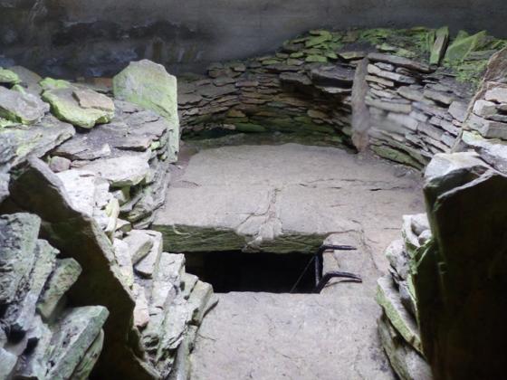
Andrew Appleby (once an excavator of cists) found a possible circle of stones between the Grimeston and Stoneyhill roads.This sparked my interest in the ‘Vola’ mound, but this year I attended an Orkney Archaeological Society talk by an Orkney College student [name escapes me] on a site called Henge, 80m diameter and cut across one end by the road. Described as little known it rings no bells. Unfortunately I could not identify the place from either image shown as this site does not show up well even in person or photograph other than badly. One of these was of a putative entrance, though without scale the devil’s advocate saw a passage into a field across a ditch. If I remember correctly geophysics had located several other interesting features round about. Dave Lynn [ex-Director of the CSA] came to see me and had visited the site, which is where the legend Staney Hill is shown on the 1:25,000 – he said it is by Henge Cottage. When he went water inside clearly defined the ditch, but as to the possible entrance he was of the opinion that this is due to one of the two tracks shown here on the first O.S. [when the present road did not exist].
Sites within 20km of Henge
-

Staney Hill
photo 13forum 1description 7 -

Feolquoy
photo 1description 3 -

Pickaquoy
photo 4description 2 -

Staney Hill
photo 17description 5 -

Appiehouse
photo 7description 5 -

Dale
photo 4description 3 -

Maesquoy
photo 1description 1 -

Grimston
photo 9description 1 -

Vola
photo 14description 4 -

Knowe of Gullow
photo 2description 2 -

Knowe of Burrian (Garth Farm)
photo 2description 2 -

Harray Viewpoint
photo 6description 2 -

Nettletar
photo 6description 2 -

Wasdale
photo 32description 10 -

Howe Harper
photo 11description 4link 1 -

Lower Hobbister
photo 5description 3 -

Maeshowe
photo 46ondemand_video 1forum 16description 30link 7 -

Knowes of Trotty
photo 6description 7link 1 -
Lyde Road
description 1 -

Barnhouse Settlement
photo 58description 4link 2 -

Hill of Heddle
photo 1description 1 -

Stone of Odin
photo 2forum 2description 11link 1 -

Ness of Brodgar
photo 3forum 3description 43link 5 -

Burrian Broch
photo 1description 1 -

Snaba Hill
photo 4description 2 -

Lochview
photo 18forum 1description 13 -

Fresh Knowe
photo 9description 4 -

The Watchstone
photo 17description 8link 1 -

Plumcake Mound
photo 5description 4 -

Comet Stone
photo 26description 7link 2 -

The Standing Stones of Stenness
photo 87forum 2description 18link 3 -

Barnhouse Stone
photo 6forum 1description 5 -

Ring of Brodgar
photo 143forum 16description 22link 5 -
Ness of Brodgar Cairns
description 1 -

Salt Knowe
photo 9description 7 -

Bookan Cairns
photo 21description 4 -

Wasbister Cairn
photo 9description 1 -

Rowamo Cottage
photo 3description 1 -

Wasbister Disc Barrow
photo 16description 1 -

The Brecks
photo 49description 7 -

Bookan
photo 15description 3link 2 -

Burrian (Russland)
photo 2description 3 -

Ring of Bookan
photo 9description 14link 1 -

Burrian (Corrigall)
photo 5description 3 -

Skae Frue
photo 9description 6 -
Nether Bigging
description 2 -

The Hillock
photo 15description 3 -

Standing Stones Hotel
photo 2description 4 -
Shennar Howe
description 2 -

North Biggin
photo 9description 3 -
Rosemount and Easthouse
description 1 -

Stackrue-Lyking Mound
photo 4description 2 -

Stackrue Broch
photo 15description 6link 1 -

The Fairy Knowe
photo 55forum 1description 12link 2 -

Hourston
photo 3description 2 -

Unstan
photo 64description 10link 1 -

Point of Onston
photo 1description 3 -
Linga Fold
description 1 -

Voy
photo 25description 3link 1 -
Dounby House
description 1 -

Via Mound
photo 6description 2 -

Via Mound
photo 3description 3 -
East House
description 1 -

Stones of Via
photo 3forum 1description 3 -
Stockan
description 1 -
Vetquoy
description 1 -

Deepdale
photo 15forum 1description 6 -
Knowe of Makerhouse
description 2 -
Via Barrow
forum 1description 3 -

Cummi Howe
photo 13description 4 -

The Howe
photo 2description 2 -

The Howe
photo 10description 2 -

The Howe
photo 4description 1 -

Corn Hillock
photo 5description 3 -

Chapel Knowe
photo 1description 2 -
Harraymen’s Graves
description 1 -

Voy
photo 4description 1 -

Burn of Cruland
photo 2description 1 -

Loch of Clumly
photo 4description 2 -
Quinni Moan
description 1 -
Hurkisgarth
forum 1description 3 -
Grind
description 1 -

Oyce of Isbister
photo 1description 3 -

Ingshowe Broch
photo 19description 2 -

Ward Hill
photo 3description 1 -

Quholm, Burn of Una
photo 12description 2 -

Nabban
photo 6description 1 -

Loch of Skaill Niche
photo 2forum 1description 2 -

Rennibister
photo 33description 5link 4 -
Knowes of Howana
description 1 -

St Mary’s Kirk (Isbister)
photo 7description 1 -

South Seatter
photo 1description 2 -

Russel Howe
photo 10description 3 -

Quoyelsh
photo 9description 2 -

Sandyhall
photo 4description 2 -

Knowe of Angerow
photo 11description 2 -

Seven Knowes
photo 8description 2 -
Millhouse
description 1 -
Knowe of Nebigarth
description 3 -

Skaill road
photo 1description 2 -

Wideford Hill
photo 8description 2 -

Broch of Borwick
photo 18description 6link 1 -

Wideford Hill
photo 42description 8link 1 -

Knowe of Geoso
photo 8description 4 -

Sower
photo 5description 2 -

Skaill Church
photo 1description 2 -

Skara Brae
photo 64forum 6description 21link 5 -

Graystane
photo 4description 4 -

Linnahowe
photo 7description 5 -

Quanterness
photo 5description 4 -

Knowe of Verron
photo 21forum 2description 3 -

Upper Garson
photo 1description 1 -

Brough of Bigging
photo 6description 3 -
Vestrafiold
description 1 -
Knowes of Yonbell
description 1 -

Loch of Boardhouse
photo 4description 5 -

Wideford
photo 5description 3 -

Konger’s Knowe
photo 12description 6 -

Crossiecrown
photo 2description 1 -

Brockan
photo 10forum 1description 2 -

Tingwall
photo 23description 5 -

Queena Fjold
photo 15description 4 -

Hillock of Breakna
photo 10description 4 -
Berrydale
description 1 -

Leafea
photo 16description 6 -

Ravie Hill
photo 1description 3 -

Gyre
photo 2description 2 -
Knowe of Skorn
description 1 -
Knowe of Nesthouse
description 2 -

Redland South
photo 12description 4 -

Spurdagrove
photo 3description 3 -
Quoys
description 1 -

Knowe of Midgarth
photo 10description 2 -
Redland North
description 1 -

Knowe of Dishero
photo 13description 2 -

Breckness
photo 12description 2 -

Harproo
photo 4forum 1description 4 -
Kirbister Hill
description 1 -
Hundland Hill
description 1 -

Saverock
photo 7description 4 -

Toy Ness
photo 11description 1 -

Saverock
photo 9description 6 -

Knowe of Stenso
photo 11description 2 -

Ness of Woodwick
photo 10description 2 -

Knowe of Grugar
photo 12description 3 -

Broch of Burgar
photo 5description 1 -

Burgar
photo 10description 2 -

Grain Souterrain
photo 24description 6link 1 -

Pickaquoy
photo 7description 3 -

Wheebin
photo 9description 6 -

Broch of Gurness
photo 37description 8link 2 -

Mittens
photo 1description 3 -

Lingrow
photo 7description 3 -

Oxtro Broch
photo 11description 3link 1 -

Newan
photo 4description 3 -

Broch of Lingro
photo 17description 8 -
Lower Arsdale
description 2 -

Stanerandy
photo 11description 7 -

Peterkirk
photo 5description 2 -

Crantit
photo 18forum 1description 4 -

St. Magnus’s Well
photo 4description 2 -

Nether Crantit
photo 5description 1 -

Knowes of Lingro
photo 7forum 1description 5 -

Knowes of Lingro
photo 2description 1 -

Costa Hill
photo 2description 3 -

Scapa
photo 2description 3 -

Knowe of Crustan
photo 8description 5 -

Hillhead Well
photo 4 -

Knowe of Burrian
photo 5description 1 -

Crustan
photo 2description 3 -

Hillhead Enclosure
photo 16description 5 -

Green Hill of Quoyness
photo 7description 2 -

Long Stone
photo 8forum 1description 3 -

Knowe of Lairo
photo 12description 6link 2 -

Twi Ness
photo 3description 2 -

Knowe of Buckquoy
photo 6description 6 -
Westness
description 1 -

Brough of Braebister
photo 15description 2 -

Knowe of Ramsay
photo 3description 1 -

Point of Buckquoy
photo 7description 4 -

Point of Buckquoy
photo 4description 1 -

Knowe of Yarso
photo 28description 5 -

Knowe of Hunclett
photo 6description 1 -

Knowe of Rowiegar
photo 4description 1link 1 -
Knowe Of Swandro
description 1link 2 -

Setter Noost
photo 11description 1link 1 -

Blackhammer
photo 23description 3link 1 -

South Howe
photo 1description 3link 1 -

Midhowe
photo 12description 4link 1 -

Broch of Midhowe
photo 14description 2 -
Taversoe Tuick
photo 45description 4link 2 -
North Howe
description 1 -

Long Cairn
photo 49description 13 -

Berstane Broch
photo 9description 1 -
Whoom
description 1 -

Dwarfie Hamars
photo 6description 1 -

The Dwarfie Stane
photo 46description 18link 4 -
Quendal
description 1 -

Tammaskirk
photo 14description 1link 1 -

Knitchen Hill
photo 3description 1 -

The Five Hillocks
photo 5description 3 -

Cubbie Roo’s Burden
photo 4description 2 -

Patrick Stone
photo 3description 1 -

Broch of Steiro
photo 19description 2link 1 -
Howe of Staneloof
description 1 -

Staneloof
photo 3description 1 -

Ston Loe
photo 1description 2 -
Knowe of Lingro
-

Craw Howe
photo 1description 4 -

Howe Hill
photo 4description 1link 1 -

The Five Hillocks
photo 6description 3 -

Loch of Wasbister
photo 4description 3 -
Yinstay
description 1