|
|

|
Exmoor (Somerset): Latest Posts |
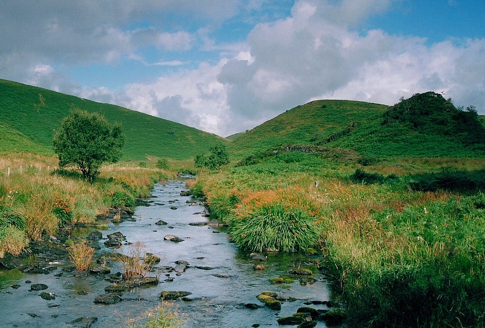
Porlock Stone Circle — Fieldnotes |
| 22/03/2017 – Nice walk from Porlock through Hawkcombe Woods to this stone circle. Easy access from the road through a gate. I liked this one a lot. The setting in the landscape is very good with a grand view of the surrounding moor. Enough stones left to still give a good feel to the place. Always good to visit a new circle for me. Well worth the trip. |
 Posted by thelonious
26th March 2017ce |
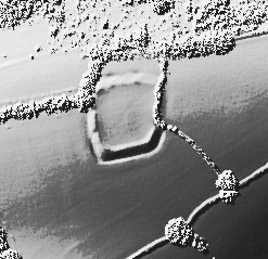
Cow Castle (Ancient Village / Settlement / Misc. Earthwork) — Images (click to view fullsize) |
|
 Posted by GLADMAN
28th April 2016ce |
Lanacombe 4 (Standing Stones) — Miscellaneous |
|
Details of stones on Pastscape SX 78644316 Stone setting LANACOMBE IV SS 7864 4316. Found by CJ Dunn during RCHME Fieldwork. (a) A poorly preserved setting comprising two upright stones set 3.6m apart, C and D, and a recumbent slab A, possibly close to its original position. The present ground plan, though probably not complete, prescribes a triangle orientated WNW to ESE. Further stones, B and E, are probably natural features. The setting occupies a lush, green area with rushy patches set amidst the vast area of coarse grass on Hanacombe. It is located on very gently sloping ground falling to the E, set back from the valley edge but well below the crest of Lanacombe. The site has extensive views in all directions bar the SW and it overlooks the valley junction of Hoccombe and Badgworthy. All the stones appear to be of local, sedimentary sandstones of the Hangman Grits series. This is one of four stone settings along the same valley side 660m SW is Lanacombe I (SS 74 SE 49); 360m SW is Lanacombe II (SS 74 SE 50) and 150m S is Lanacombe III (SS 74 SE 51). The lie of the hillside renders all three just not visible from the present site. Another setting SS 74 SE 86 is within sight on the S slope of Hoccombe Hill, 620m NW. A further table of information on the stones is held in the archive. (1) |
 Posted by Chance
17th April 2016ce |
Portford Bridge Stone (Standing Stone / Menhir) — Miscellaneous |
|
Details of stone on Pastscape A prehistoric standing stone 380m WSW of Portford Bridge. It stands 0.3m high, 0.15m wide and 0.04m thick and leans to the SW and stands within a slight erosion hollow. |
Posted by Chance 11th April 2016ce |
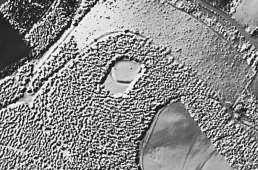
Road Castle (Hillfort) — Images |
|
 Posted by juamei
20th January 2016ce |
Staddon Hill Camp (Enclosure) — Images |
|
Posted by juamei 20th January 2016ce |
Mounsey Castle (Hillfort) — Images |
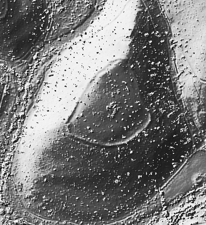
|
Posted by juamei 20th January 2016ce |
High Bray no. 9 (Round Barrow(s)) — Miscellaneous |
|
Details of barrow on Pastscape (SS 72553769) Tumulus (NR) (1) "High Bray No 9", bowl barrow visited by Grinsell in April 1949.Diameter 17 paces, height 1 1/2'. (2) A bowl barrow up to 18.0 metres across and 0.6 metres high.Published survey 1:2500 revised. (3) A Bronze Age barrow, as described above, is clearly visible on aerial photographs as a sub-circular earthwork measuring approximately 17.5 metres in diameter. It is part of a group of at least five barrows situated on high ground north of North Twitchen, Brayford (4). |
Posted by Chance 9th March 2015ce |
Rowbarrow ring barrow and a round cairn (Cairn(s)) — Miscellaneous |
|
Details of ring barrow and a round cairn on Pastscape (SS 87414147 & SS 87464146) Tumuli (NR). Two barrows, 143 ft. apart from centre to centre. The first is a disc-barrow, a slight mound surrounded by a nearly circular bank 58 ft. in diameter at the crest and 72 ft. at the foot of the bank. Indications of an inner ditch. The second barrow E of the first is a cairn of stones much mutilated. No indication of a ditch. Diameter c. 56 ft.Cutcombe 1; SS 87414147, 24 paces across and 1.5 ft. high, apparently a saucer barrow. Cutcombe 2; SS 87464146, 17 paces across and 4.5 ft. high. Cairn with modern stone heap, much dug away from west and south-west. (4) The feature listed by Grinsell as Cutcombe 1 appears to be a saucer barrow. (GPs AO/65/178/1 & 2). The other feature is a disturbed cairn. Published 1.2500 survey revised. (5) SS 87414147. Cutcombe 1. Apparently a saucer-barrow comprising a central mound 32ft. diameter, 1ft. 6ins. high, enclosed by ditch circa 8ft. wide and outer bank circa 12 ft. wide. The ditch is circa 9 ins. deep externally and bank c 9 ins high. Described in error by Authority 2 as a disc barrow. SS 87464146. Cutcombe 2. Cairn surmounted by modern stone heap, listed as Authy 4. Possibly called White Barrow (see also SS 84 SE 2). Both visited by Grinsell 25th May 1958. Cutcombe 4a. "One or two of Rowbarrows had been examined incompletely" on 2nd November 1807 (6 & 7). (SS 84 SE 8, 9 & 10 are known as 'Rowbarrows') A ring barrow and a round cairn situated in a prominent position on a rounded hilltop at 510 metres O.D.; part of the linear Rowbarrow group(see also SS 84 SE 9 and 10). SS 8741 4147. An impressive and well preserved ring-barrow 22.9 metres in overall diameter with a slightly off-centre saucer-shaped mound and a slightly sub-circular enclosing bank. The mound is 12.7 metres in diameter, 0.3 metres high with a shallow depression in its top where a few random largish stones are evident. The back which apparently gently slopes from south to north varies in width from 2.8 metres on the lower side to 5.2 metres on the upper side. Its height is on average 0.6 metres externally and 0.4 metres internally. The ditch noted by an earlier authority is a misinterpretation of the junction of the edge of the mound and the inner scarp of the bank. The barrow is a variation on the south west cairn platform with rim bank. SX 8745 4146. This heavily disturbed cairn, lying 8.0 metres south-east of the barrow, measures from 14.3 metres to 16.0 metres across and has a maximum height of 1.4 metres. It appears to be mostly composed of small stone although a few larger boulders are visible. The south west side has been dug away and no traces of kerbing are evident in the exposed sides. Two small, probably modern, cairns havebeen constructed on its top. Shallow amorphous quarry pits, presumably a source of barrow material,lie between the mounds. No further information was gained on the name "White Barrow". It is not noted on the maps of Day and Masters (1782) or Greenwood (1822). Visible on A.P.s (12-13) (14) A well preserved ring barrow and a round cairn, forming part of the Rowbarrow group, are visible as earthworks on aerial photographs, to the west of Dunkery Beacon, centred on circa SS 87424147 and SS 87464146 resprectively. The diameter of the ring barrow outer enclosing bank measures approximately 20 metres at the outer edge, the inner mound almost 10 metres in diameter. The cairn lies 28 metres south east of the barrow and is almost 10 metres in diameter. Numerous small and shallow quarries, which might be the source of the building material for the monuments, are visible between the mounds. (16-19) |
Posted by Chance 8th March 2015ce |
Little Rowbarrow (Cairn(s)) — Miscellaneous |
|
Details of cairn on Pastscape (SS 87884156) Little Rowbarrow (NR). Tumulus, known as 'Little Rowbarrows' probably composed chiefly of stone. It has been dug into considerably in the middle. Diameter about 65ft., ht. 5ft.6in. Cutcombe 4. A cairn with a hollow entre. 23 paces in diameter and 4ft.6in. high. (4) This is a cairn 15m. high. A large hole has been dug in the centre. See G.Ps AO/65/127/1 and 2 (Stereo pair). Published survey (25") revised. (5) SS 87864155. Cutcombe 4. Little Rowbarrow listed as Authy 4. It is named Little Barrow on the Tithe Map of 1840. Cutcombe 4a. "One or two of Rowbarrows had been examined incompletely" on 2 November 1807 (SS 84 SE 8, 9 & 10 are known as 'Rowbarrows'). (6-8) SS 8788 4156. Little Rowbarrow; a fairly well defined cairn situated on the top of a rounded hil at 503 metres O.D. Composed of both large and small stones, it measures 19.0 metres in diameter with a maximum height of 1.4 metres; the central depression is 4.8 metres in diameter and about 0.5 metres deep. The heather-covered sides are fairly sharply defined although there is evidence of disturbance (? excavation trench) on the west side, and material from the central depression has been piled around the top edge. A crude (? modern) 1.0 metres high cairn has been constructed on the upper east side. There are no quarry pits near this cairn as occur with the others of the group (qv SS 84 SE 9 and 10). Visible on A.P.s (c,d). (10-12) The cairn is as described by authority 8 and lies at SS 87876 41563. It was surveyed using GPS as part of the RCHME East Exmoor project (13). The well defined Bronze Age cairn known as Little Rowbarrow is clearly visible as an earthwork on aerial photographs to the west of Dunkery Beacon, centred on circa SS 87874156. The mound is roughly oval in shape, measuring 19 metres on the south-west to north-east axis and 17 metres north-west to south-east. An irregularly shaped central depression approximately 6 metres in diameter is visible near the centre of the top of the mound. (11,14) |
Posted by Chance 8th March 2015ce |