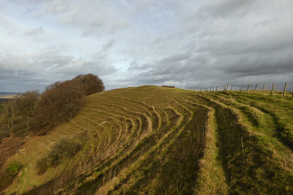
I loved the striations on the side of the hill below the southern round barrow.
Image credit: A. Brookes (5.2.2022)
I loved the striations on the side of the hill below the southern round barrow.

A closer look at the ongoing damage to the long barrow.

The sorry sight of the long barrow, further damaged by the plough since tjj’s photos from a decade earlier.

This may be the northern round barrow, although it’s not quite in the position shown on the OS 1:25000 map.

Looking east across the top of the southern round barrow. Morgan’s Hill on the left, Tan Hill and the high Wiltshire ridge on the right.

The extensive views westwards across the southern round barrow.

The southern round barrow, a well-preserved monument in a terrific location.

Ascending to the summit of the hill from the southwest. The southern round barrow is visible on the top.

King’s Play Hill from Morgan’s Hill to the ENE, another hill crowned with barrows.

King’s Play long barrow – hardly discernable (though unploughed) it sits just below the crest of the hill.

Looking downhill from King’s Play Hill

The astonishing hillocks by King’s Play Hill
The round barrow right on the edge of the slope.

A distant view of the hill, with wood clinging on for dear life and the round barrow just visible as the pointy bit right in the centre of the photo.

A tiny segment of the view from the round barrow :) If you could see round the corner, that’s where all the weird undulations are.

Morgans Hill from Kings Play Hill Long Barrow

Looking South West from the Barrow looking towards Olivers Castle

The Barrow again with Morgans Hill in the background

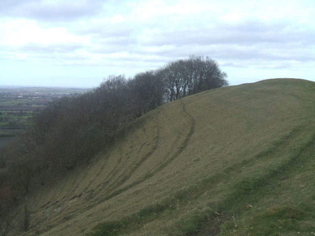
Kings Play Hill Long Barrow – The green patch with the tyre tracks going over it

Kings Play Hill looking towards Olivers Castle
Starting from the small car park by Oliver’s Castle we headed right along a trackway towards King’s Play Hill and long barrow. A typical January day, chilly with a hint of rain in the air but it was a pleasure be out on the Wiltshire Downs again. A round barrow sits on the crest of King’s Play Hill, to get to it we did a back shuffle under a barbed wire fence (a first for me) to come upon an amazing almost sheer drop on the other side of the hill – made negotiable only by the tiers of sheep tracks.
My walking friend, being a keen map-reader, pointed out the long barrow, although not very prominent, sat just below the crest of the hill – where we had just come from on the other side of the barbed wire, so back we went to take a closer look. From where we were standing we could also see the round barrows in the distance on the highest point of Furze Knoll near Morgan’s Hill.
Ultimately, we were heading for the village of Heddington to pick up the track at the bottom of Roundway Down back to Oliver’s Castle so it was under the barbed wire again to make our way downhill along the sheep tracks. This is when the astonishing hillocks that Rhiannon mentions in her fieldnote came into view – similar to the ones near Oliver’s Castle but far more ridged (see photo).
Once on lower ground our way became very muddy; at one point we had to pass through liquified mud by a farmyard near Heddington. A farm worker directed us to the path ‘up on the left’. I looked up and heard my horrified voice say “But there’s a dead cow lying there”.
Farm worker: “Yes, she dropped dead yesterday.” Horrified Voice: “Oh ... what are you going to do with her.”
Farm Worker: “The hunt will have for the hounds”. For a townie out walking, this is one of the unpalatable realities of country life.
This place is totally mad. It’s impossible for me to take photos that describe it. That’s because for one thing, there are these mad ‘earthworks’ – they’re not really earthworks, they’re dry chalk valleys. But from some angles you’d think you were looking at a hill fort with snakey defence ditches. Secondly, once you’ve climbed up to the top, the slope drops off in an insanely steep way, very suddenly. And thirdly, you are confronted with the most enormous view. From the vantage point of the round barrow on the crest, you have a 360 degree view – one way out to the north and west out over the steep slope and away to goodness knows where (I felt like I should be able to see the glitter of the sea, but that’s a bit too much) – but with a quite different feel to the south and east, which has that vast minimalist curveyness like the Salisbury Plain.
The long barrow is barely perceptible, but you just think: what on earth is it doing where it is? You had that view and you stick it there? Clearly the builders’ priorities were different from mine. Surely it is knowingly near the Edge but yet deliberately not near enough to see the view. A liminal spot but not on the distracting boundary. I don’t know. I’d love to know what others would think.
Having footled about for a bit I sat for a while looking out in the late afternoon sun. There’s Heddington church at the bottom of the hill but a place like this has surely always to have been better for thinking about stuff.
(I left the car backed up to a tree near a barn at SU010656. This is the old Bath-London coach road – you can rather imagine it when you know? Then I walked back and through a squeaky gate near the sign ‘dogs to be kept on lead’ (not the track through the open gate to the sign’s right). This side of the fence is open access land with a little on the other side of the sunken lane. Then it’s not too badly uphill a walk for long, just rough grassland underfoot, though don’t go too near the water trough or the reservoir, as the ground’s craftily boggy :) Aim for the corner and the world opens up in front of you).
King’s Play Hill is prominent in the landscape – part of the striking undulating hills that rise out of the flat land below. The slope is steepest to the north-west, but the longbarrow here is sited just below the crest on the south-east side. This gives it extensive views over the Vale of Pewsey (rather than the view of the flat Neolithic desert south-east of Chippenham, which it could otherwise enjoy). The mound only stands 1m high now, and is orientated in the popular NE-SW direction. Cunnington dug into it in the 19th century to disturb a crouched skeleton and a number of flint flakes.
There are also two later bowl barrows on the hill’s crest – these would probably be visible from a wider variety of directions therefore? According to the Victoria County History, one of these was reused for a burial in Saxon times (though this is not mentioned in the EH SMR).


