Image credit: A. Brookes (1.6.2024)

Northeastern rampart.

Southeastern rampart with entrance top right.

Southwestern ramparts.

Low round barrow near the highest point of the hill, inside the fort.

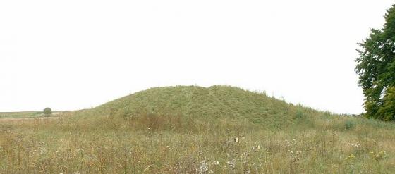
Very impressive round barrow inside the rampart at the southwest of the fort.

Western ramparts, with Middle Hill over on the left.

Western ramparts.

Looking across the ramparts towards nearby sites: Cley Hill hillfort (far left skyline), Cop Heap round barrow (prominent hill left of centre), Battlesbury (right of centre), Middle Hill round barrow (topped with trees, far right).

Scratchbury from the northwest, on the slopes of Middle Hill.

Nice curves.

Battlesbury, field systems and Middle Hill viewed from Scratchbury.

The largest bowl barrow on the hill with one of those archaeological star sign thingammies on top.

Looking South East across the Wylye Valley.

Looking West along the Southern ramparts with Cley Hill just visible on the left.

Open Source Environment agency LIDAR

The prominent barrow at the edge of Scratchbury. Cley Hill is on the horizon behind.

Looking towards Cotley Hill, I believe.....


This is the west slope of Scratchbury

This is taken from Middle Hill between Scratchbury and Battlebury
Taking advantage of the decidedly spring-like weather I have just made my first visit to Scratchbury. There’s room to park just off the roundabout at ST914437 and then you can walk up the slope of Cotley Hill and across the down to the hillfort. I am not built for slopes and it nearly killed me (it’s not that bad really and is quite a decent path. There’s a stile right at the bottom and a kissing gate further on). The advantage of physical exertion and lack of oxygen to the brain means that when I do finally get to the top of these places, I’m feeling slightly peculiar. And this adds to their sense of being above the mundane. You can see and hear the traffic below but you’re well out of it in another world. I do like that.
Cotley and Scratchbury are an SSSI and there will be very interesting things to see there soon
https://www.english-nature.org.uk/citation/citation_photo/1001995.pdf
Today I was accompanied for some way by my first butterfly of the year, a brimstone. The plateau is full of peculiar mounds and dips, some of them clearly barrows, some of them more mysterious. Lumps of flint and chalk are everywhere. As usual I had my eyes peeled for that elusive arrowhead, in vain.
When you get to Scratchbury from this direction you are met by a huge bank. In fact the whole place is much bigger than I was expecting. I see now from this photo at Last Refuge that there is also a distinct inner enclosure. I was quite happy sitting on the very prominent barrow overlooking the view and unusually didn’t feel the urge to pace round the whole perimeter. I felt quite at peace. Thus I can’t really comment on the parking / climbing opportunities from the other direction. But I enjoyed the walk to and from the fort. I saw half a dozen people while I was up here, a positive Picadilly Circus compared to many similar spots.
It was rather restorative. I think I’ll be back.
Norton Bavant. ... The village lies at the foot of a remarkable old British encampment known as Scratchbury, one of the finest, largest, and best preserved of the many in this neighbourhood. Leading up the encampment is what is known as “The Nuns’ Path,” and it is stated that a nunnery formerly existed near Scratchbury, at a place called Middleton, which forms part of Norton Bavant Parish.
The Warminster Herald, 12th August 1882.
Could ‘Scratchbury’ come from ‘Old Scratch’ – the Devil? I mean he was about the area, having made Cley Hill, so it’s not inconceivable he might have sat here.
The Oxford English Dictionary has an example of this euphemism’s use from 1740 – but its older forerunner ‘scrat’ and other similar words mean all kinds of gobliny devilish things in Old Norse and German.
According To Nicholas Thomas (A guide to Prehistoric England) Rhiannon..he says this about Scratchbury;
“This superbly placed hillfort, looking across at Battlebury Camp, encloses 37 acres within a bank and ditch with a counterscarp bank. Its irregular four-sided shape follows the contour of a steep hill. There are two entrances on the E side, and possibly a third on the N.W.. Remains of a much smaller inner earthwork of much smaller size can be seen. This resembles the earlier enclosure at Yarnbury and has recently been dated 250 b.c...He goes on to say that there is a romano-british or later ditch, running E/W, and turning S, sharply at the SW corner of the hill-fort overlies the I/A eartworks. Main ramp[art must have been built in the 1st C. BC”
Siegfried Sassoon lived nearby, and wrote this poem about Scratchbury Hill.
On Scratchbury Camp
Along the grave green downs, this idle afternoon,
Shadows of loitering silver clouds, becalmed in blue,
Bring, like unfoldment of a flower, the best of June.
Shadows outspread in spacious movement, always you
Have dappled the downs and valleys at this time of year,
While larks, ascending shrill, praised freedom as they flew.
Now, through that song, a fighter squadron’s drone I hear
From Scratchbury Camp, whose turfed and cowslip’d rampart seems
More hill than history, ageless and oblivion – blurred.
I walk the fosse, once manned by bronze and flint head spear;
On war’s imperious wing the shafted sun ray gleams:
One with the warm sweet air of summer stoops the bird.
Cloud shadows, drifting slow like heedless daylight dreams,
Dwell and dissolve; uncircumstanced they pause and pass.
I watch them go. My horse, contented, crops the grass.