Image credit: A. Brookes (11.3.2019)


Looking south.

The fifth stone (in the foreground) has been moved from the arc and left by the wall. I’m not sure if it’s the stone that was up in Greywether’s photo.

05/05/2016 – Doddington Stone Circle

05/05/2016 – Still standing
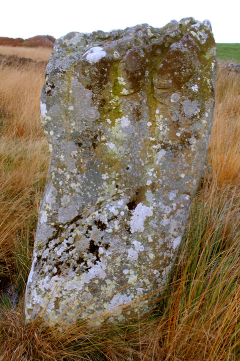
Central standing stone of Doddington Stone Circle – the only one now standing (as of November 2009)

Only 1 stone left standing now. Bad show gravity.


Framing the Bowden Doors


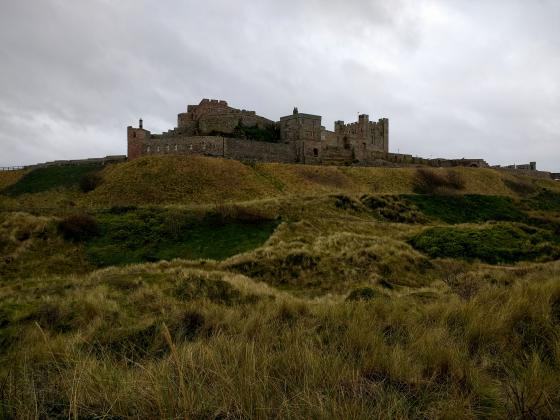
The stone circle on Doddington Moor

From October 1997 when three stones were still standing.

Taken 9-2-2003 – top of the almost-fallen stone
.o0O0o.

Taken 9-2-2003
.o0O0o.

Taken 9-2-2003
.o0O0o.

Taken 9-2-2003
.o0O0o.

Taken 9-2-2003 – the largest stone
.o0O0o.

Taken 9-2-2003 – looking east
.o0O0o.

Taken 9-2-2003 – looking north
.o0O0o.
01/05/2016 – I’d been looking forward to this one. A quick look at the map showed a hill jam packed with stuff – cup and ring marked rocks, hillforts, settlements and even a stone circle.
We started from Wooler. Walking over Weetwood Moor via the St Cuthbert Way (passing a few cairns on top) then crossing the Weetwood bridge to start the climb up Dod Law. Good paths all the way.
After reading the fieldnotes on here, I was a little worried that there wouldn’t be any stones still standing. Seemed like another one had fallen each time someone visited. Pleased to say that the one remaining upright stone is still hanging in there. I would loved to have seen this one complete. It’s a lovely little circle and a fine spot.
We left the circle behind to make our way uphill, looking for cup and ring and visiting the forts on top. Fantatsic hill.
Looped back to Wooler via the rock art stones on Weetwood Moor (great site). Good day out.
I was most upset to see that one of the stones has fallen over since I last visited. It’s marked on the map as ‘rems of’, and it seems that’s a better description than ever. 3 down, 2 to go... :(
The hard way to find it is to try and follow the paths marked on the map. This involves bouncing through seriously deep heather, and annoyingly clingy bracken, trying to follow a path that isn’t really there any more, with optional extant paths that aren’t on the map and will lead you astray. But if you keep going downhill, you’ll hit the wall eventually, then you just have to decide on right or left. Whilst this can be fun, it’s not particularly recommended. It’s probably wiser to follow the path down from the Dod Law trig pillar, then turn left when you get to the wall, which I did this time, and it was quite straightforward to find the stones.
I am highly suspicious of the placing of this little circle, it draws a bead from Dod Law to the rocky outcrops of the Bowden Doors, an enigmatic site of mesolithic activity a few mile to the east.
This circle took a hell of a lot of finding on a very foggy day – be warned that the footpaths are not easy to delineate...
Walked here from The Ringses.
The OS map says this is “rems of” a circle – not fair! There are still 4 visible stones, OK two left standing but it still has the right feel. Lots of stones underfoot too. One of the fallen stones isn’t quite horizontal, you can tell which was the top surface by the characteristic weathering patterns.
Unusually for this area, the Cheviot is not visible! (shock horror) – it is obscured by Doddington Moor. To the east however, Chatton, and Weetwood to the south.
Took a few moments to enjoy the silence and to watch a pale-coloured bird flying around which I’m sure was an owl, but it was broad daylight (?)
.o0O0o.
George Tate wrote in the late 19thC:
The other two camps are on the Horton grounds. Near to one of them are the remains of a stone circle, which during the last century would have been called a Druid’s temple. Five stones are remaining, two only standing in their original position; when complete the circle had been about 100 feet in circumference; and it probably marks the burying place of some chieftain. At no great distance form it, are several barrows which also appear to have been places of sepulture. Mr Greenwell dug into some of them, but nothing was discovered save traces of burning.
Which makes me wonder where the fifth stone went, and when was the third (temporarily) re-erected? Are the two standing today the same two Tate observed? What about the cairns and can they still be found amongst the heather?