|
|

|
|
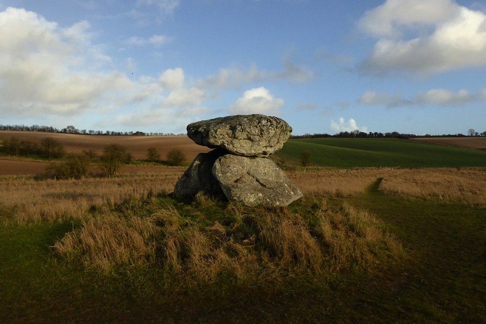
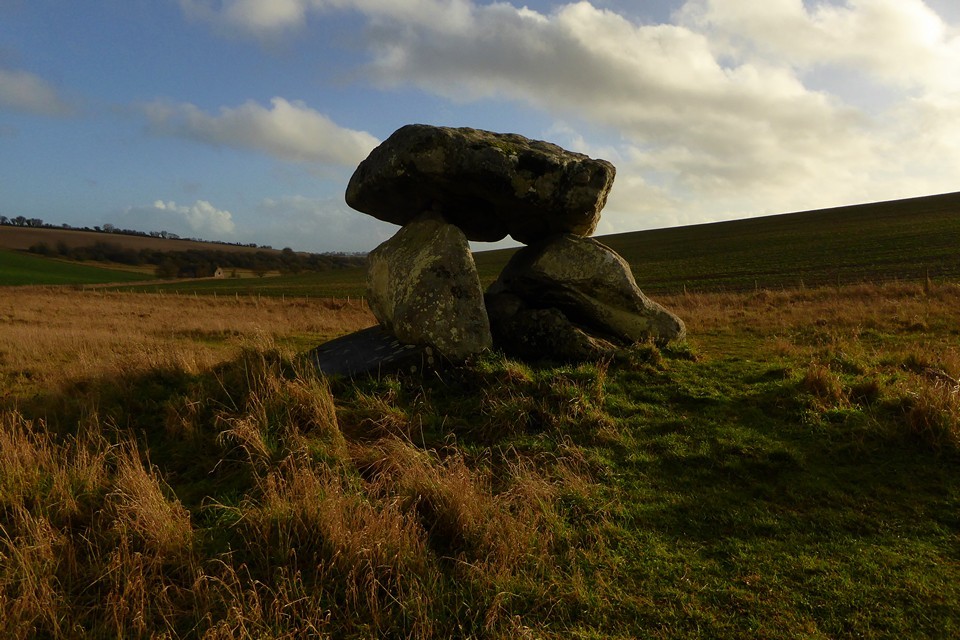
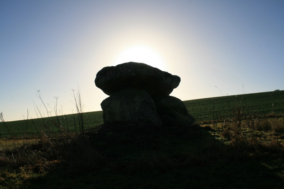
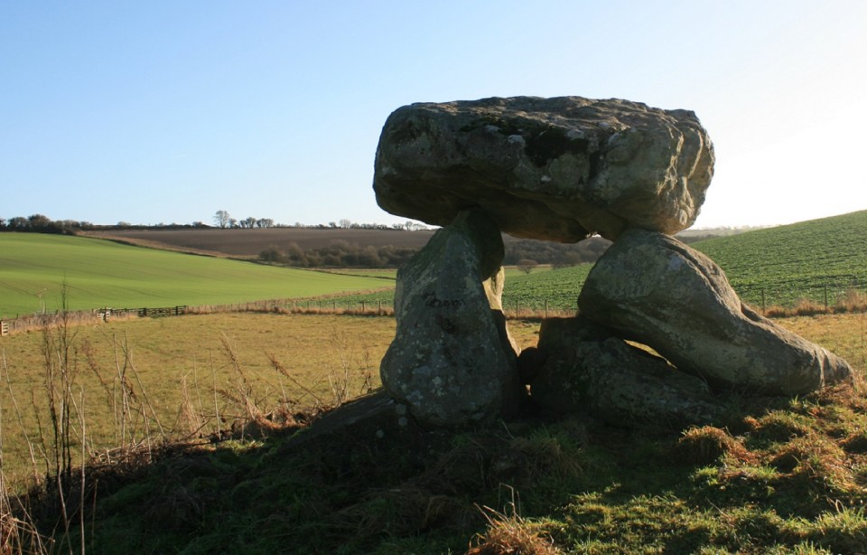
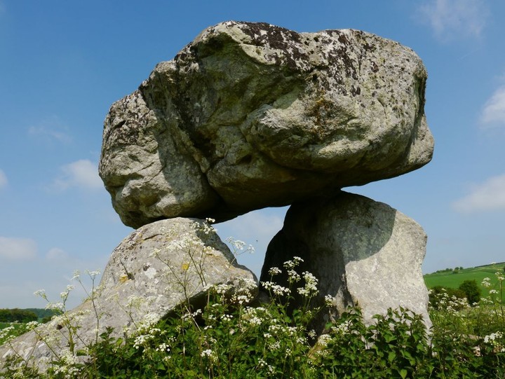
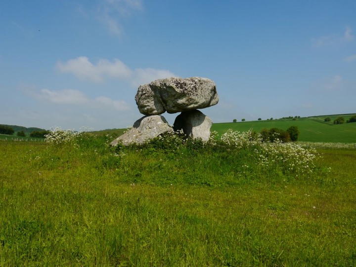
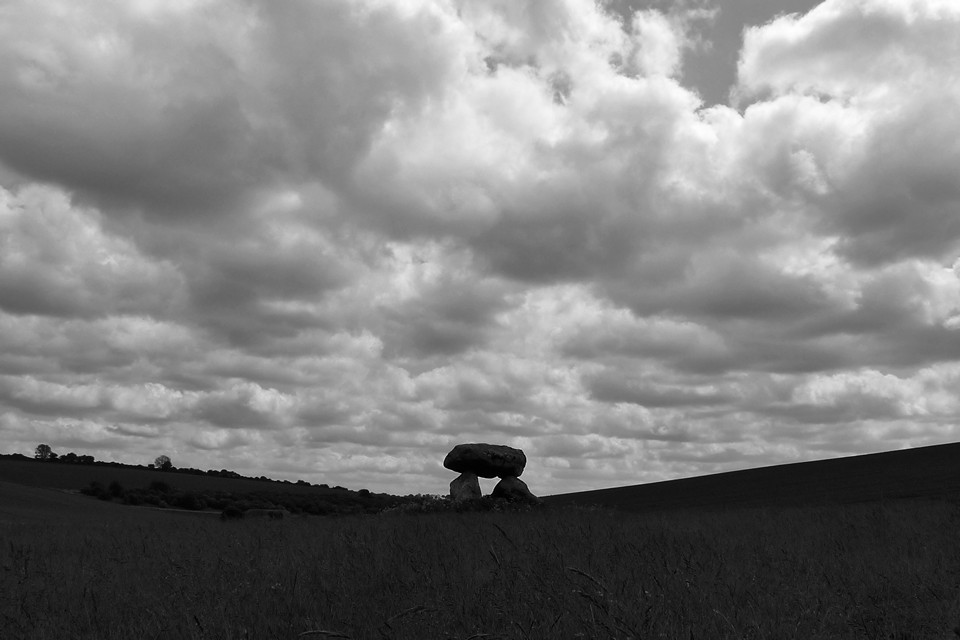
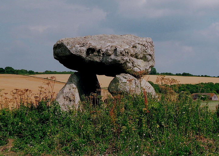
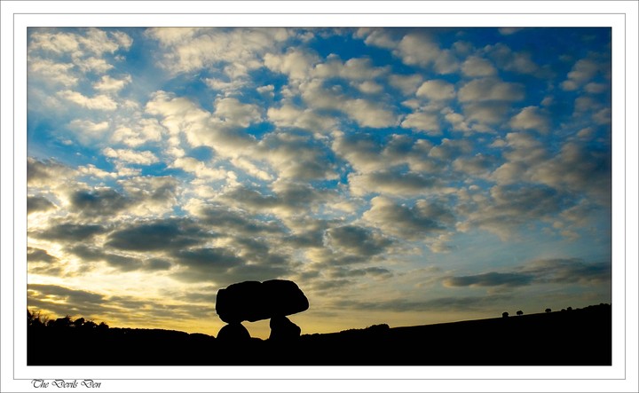
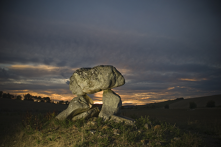
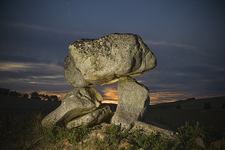
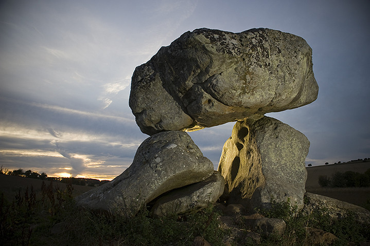
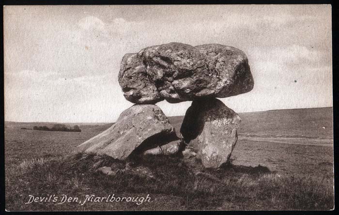
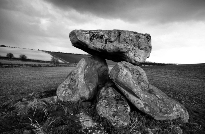
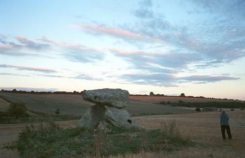
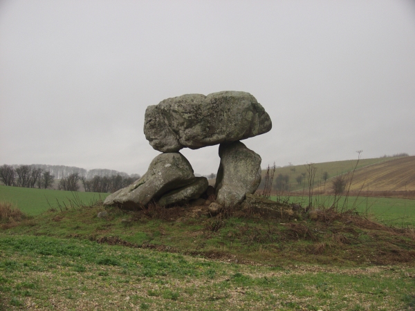
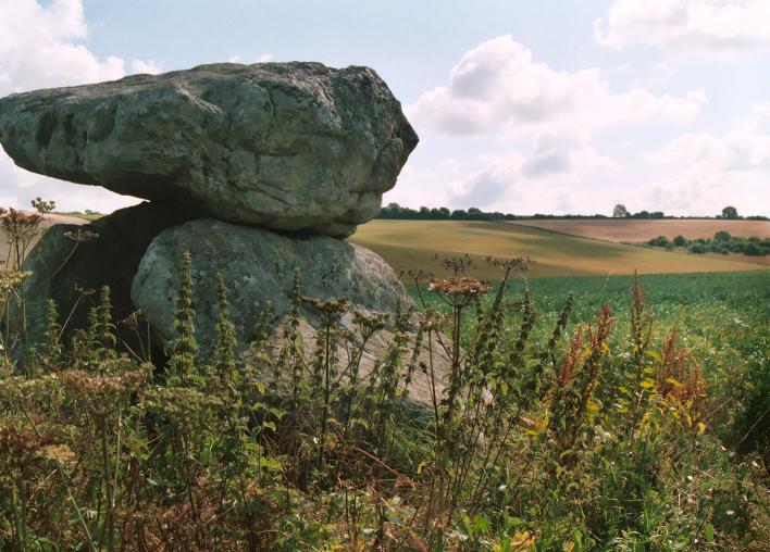
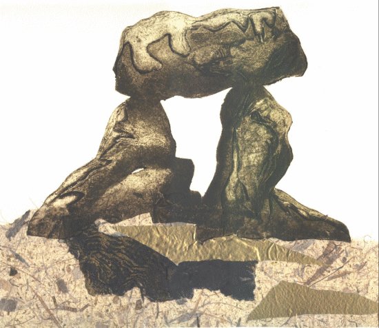
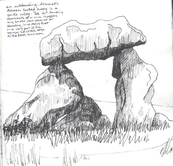
Devil's DenChambered Tomb
|
|
|
|
Images (click to view fullsize) |
|
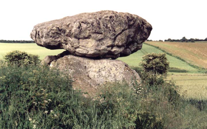
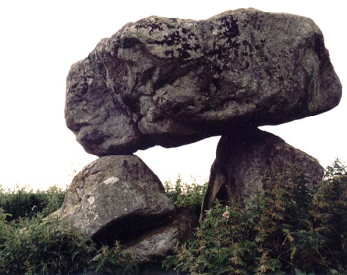
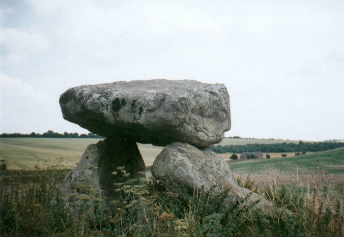
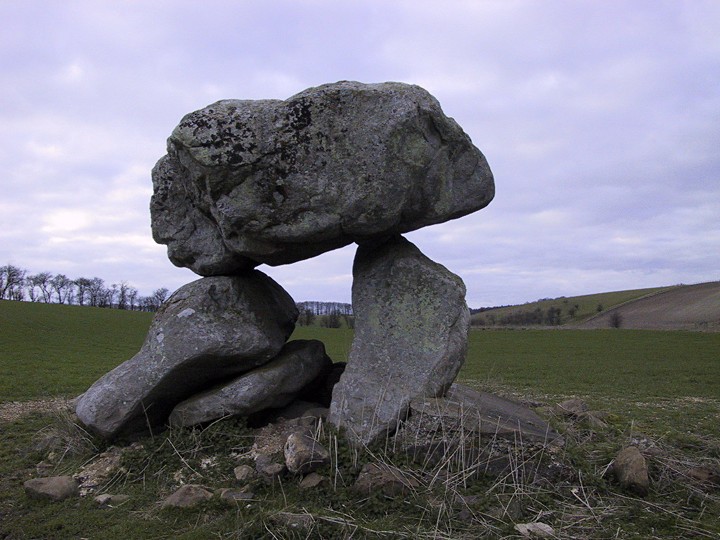
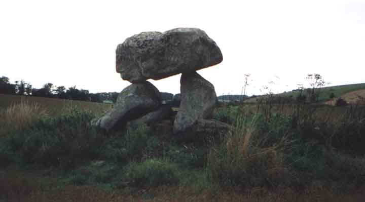
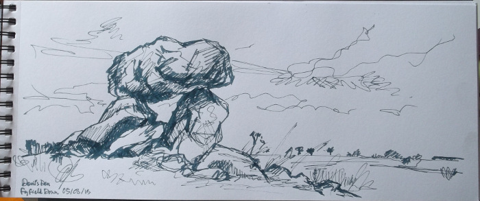
Photographs: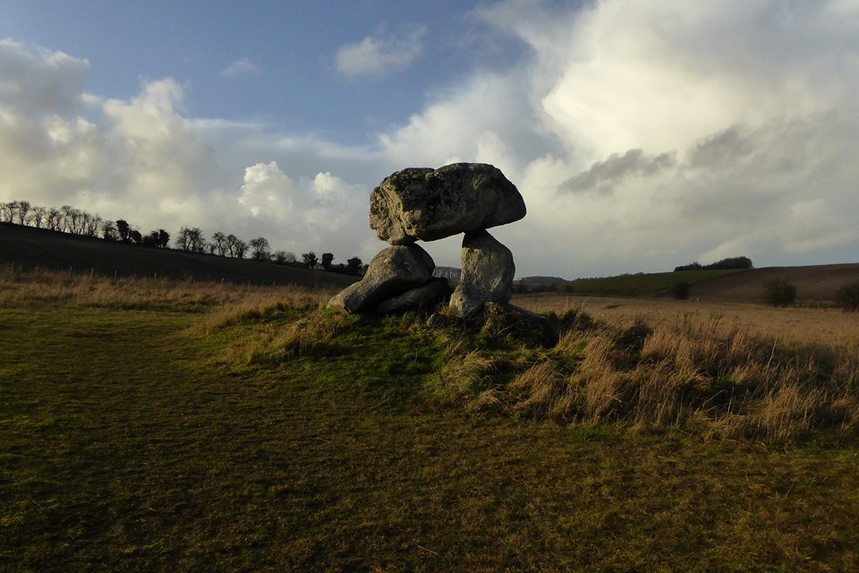


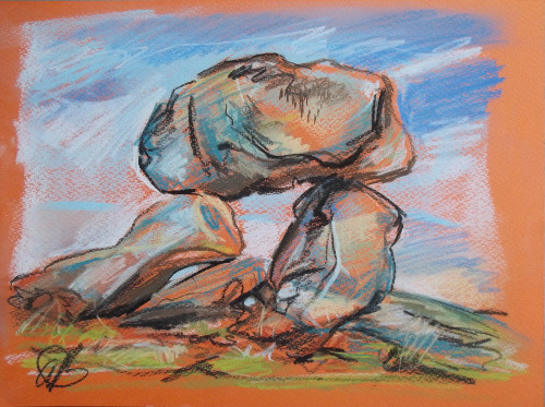
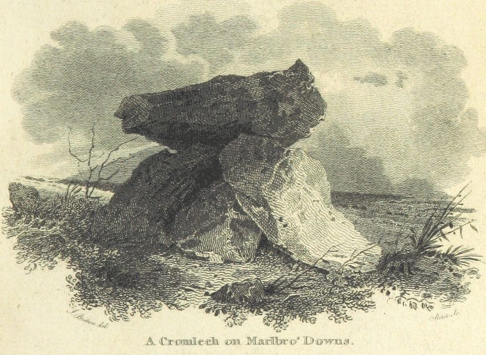
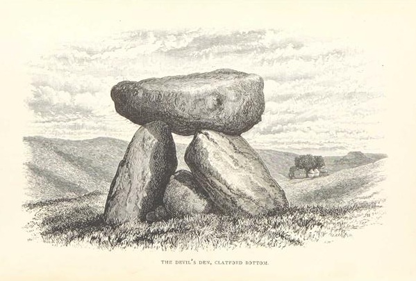
 Artistic / Interpretive:
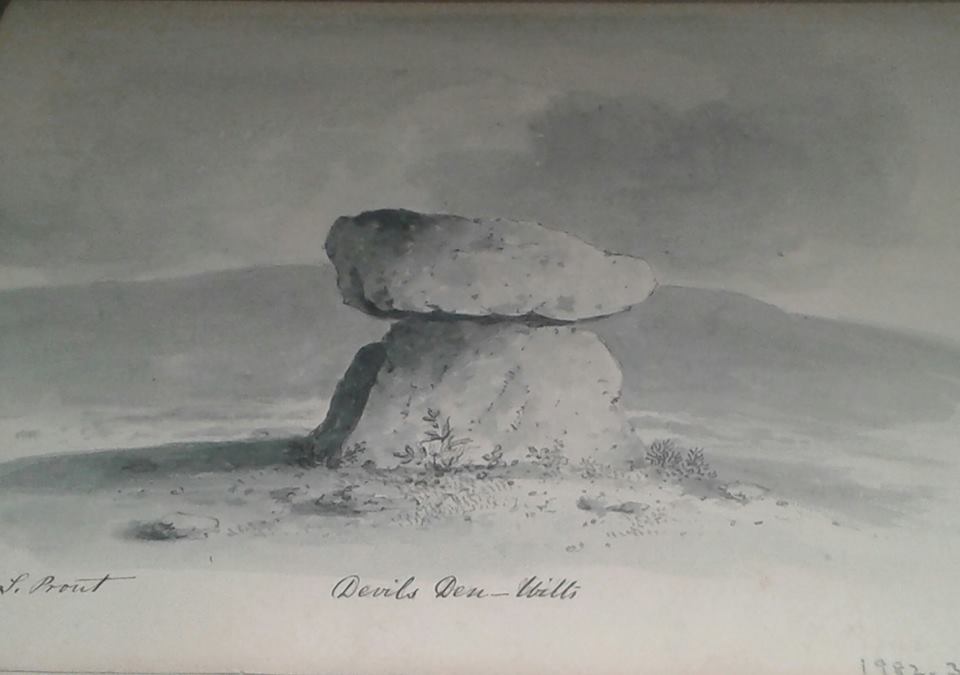
|
Fieldnotes |
|
|
I haven't been here for years, it was even before I had a digital camera, my memories of the site are kind of dulled by time but I distinctly remember being underwhelmed. Seeing as we've taken lunch from Greggs of Marlborough this would be the optimum moment to revisit and see if my memories are reliable. Parking is a problem, there is no where to do it. I tried on the main road, but that didn't feel safe at all, so I opted to park in the same place as Carl despite the sign saying park here and we'll tow you away, like Carl I left backup in the car in case of emergency. The walk up the track is very muddy, but the sun was shining, the birds were flying and I was ready for some stones. As you get to the barn you can see the dolmen, I pause a while here and ponder the barns use as viewing platform up the valley, decide i'm being silly and keep on splashing through the mud. I enter the enclosure of the Den and approach the stones, much is made of the fact that you're allowed to go to the stones any time you like, permission is already given. But, if there's no where to park your motor it's just a bit of a laugh isn't it, probably best to get Scotty to beam you straight to the site, walking? who needs it. A big chunk of concrete helps support the stones, no one seems to mention it much, but there you go. They also call it a dolmen, is it really a dolmen? a portal dolmen maybe? I don't think it is, yes it's a stone lifted upwards by other stones, but that doesn't make it a dolmen does it? If you like dolmens go to Wales. But none of this means I don't like it, I do, very much, what it does mean is that a place as famous as this should have a little car park, just a simple one will do, one without fear of being towed away. And I'd like to know exactly what it is that remains of what, is it really a dolmen, is it all that remains of another big chambered cairn, or is it a mad folly, were any burials found, what do we really know about it. My ponderings were then rudely broken by my daughter in the car saying that a tractor with a big spikey thing on the back was there, so I said I was on my way, waved cheerfully to the stones and left readying myself for yet another confrontation with the farming fraternity. But it didn't happen, he just passed me by on the track. Still, not hard to understand my slight disappointment with the place last time. Stones, it's not you, it's me. |
 Posted by postman
27th December 2016ce |
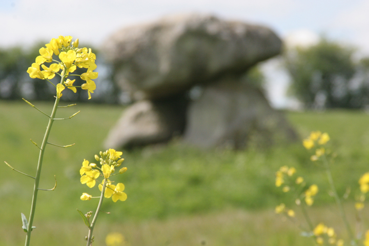
|
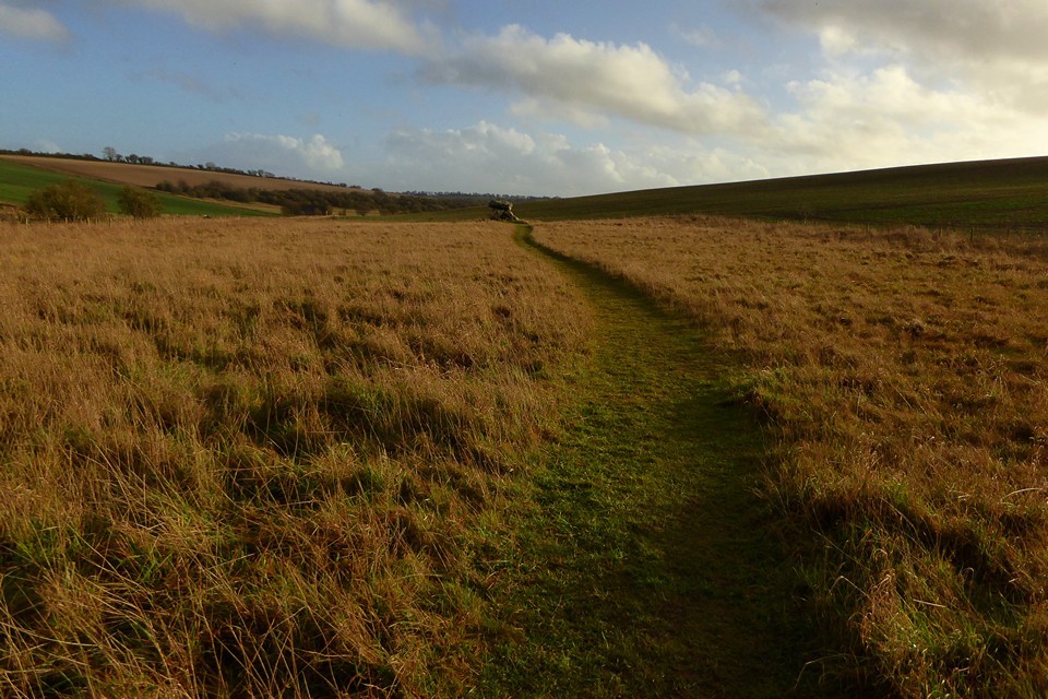
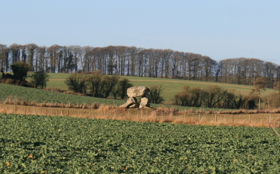
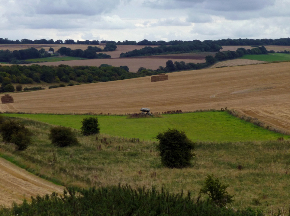
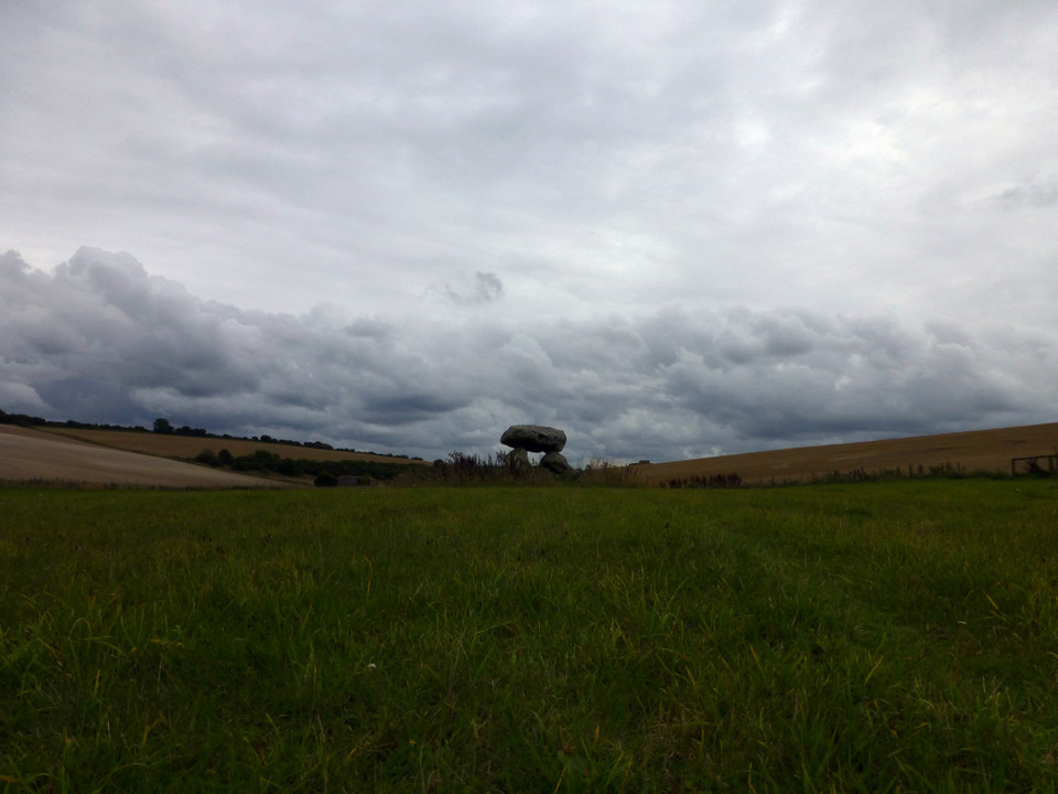
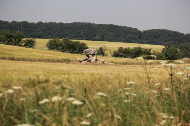
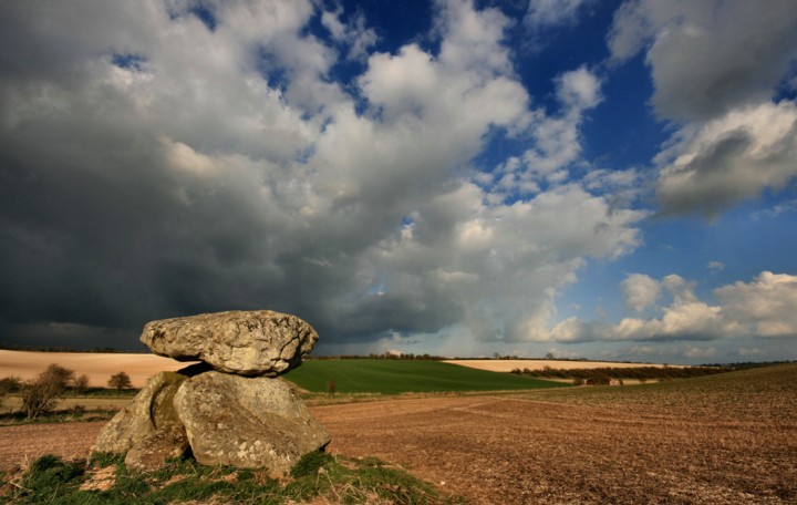
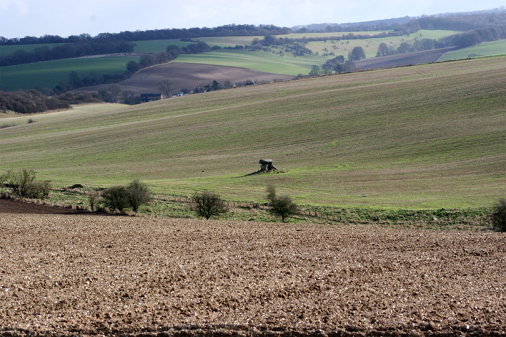
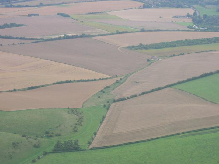
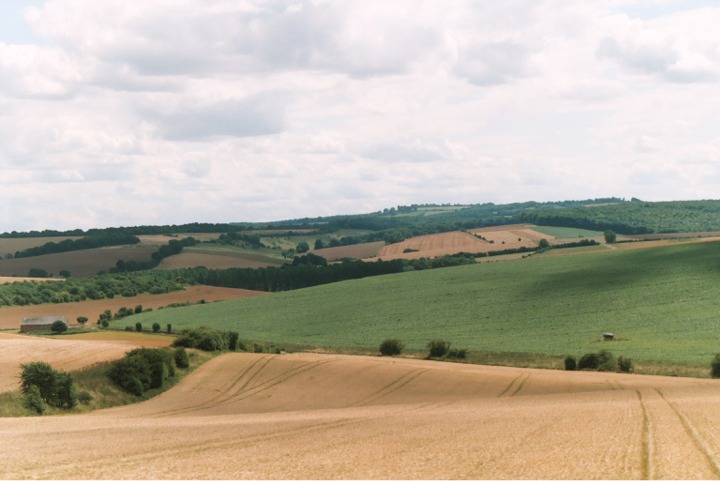
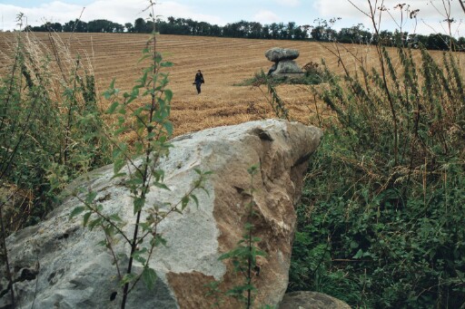
South of the Clatford Down gallops I finally part with the White Horse Trail, taking a bridleway southwest towards the second site of the day. As the path follows the contour of the hillside, Devil’s Den comes into view. This is one of those sites that you’ll already have seen, even if you’ve never been to it. Something of a celebrity, even in a county that boasts some of the biggest A-listers of them all. It’s great to see it first from afar, how it sits in its valley, tucked away below the windy downs. Devil’s Den is something of a triumph in another way, as although the OS map shows it standing off the right of way, the little triangle of land is subject to permissive access, which means you can go and spend as long as you like there without worrying about any confrontation. This is a relief, because it’s a site I want to savour. No rushing here. The chamber sits on top of a little mound, all that remains of a much larger structure. The field is turning to meadow, and will be a haven for chalkland flowers and insect life. Beneath the low spread of grasses, the surface is completely littered with chalk and bits of flint, presumably turned up by years of ploughing but now left discarded in the sun. I love this site. The whole structure looks poised, as if about the march away across the Wiltshire landscape. The sky has turned somewhat cloudy now, but rather than diminishing the visit it adds an extra drama to the backdrop. I could stay here a long time, and so I do. Time passes, not a soul approaches. Just how a site visit should be. This post appears as part of the weblog entry Ridgeway to heaven – Barbury Castle to Avebury 21 May 2011
|
 Posted by thesweetcheat
6th February 2014ce |
|
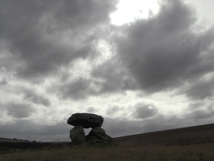
It took me a return visit the next day to finally find the Devil's Den (the day earlier I taken the wrong byway, only to spot the Den down in the valley below, as the light faded, and the weather worsened). But, on this morning I was determined to visit it, and so the walk from Clatford, through the ankle-twisting frozen ridges of mud was always going to be worth it. Sitting peacefully in a little amphitheatre of surrounding slopes, the monument looks more striking from a little distance away. Could have stayed for longer, soaking up the place, despite the bitter cold. |
Posted by ruskus 13th March 2013ce |
| Well I made to to see this today, followed scubi's directions by turning off the A4 just after it leaves Marlborough to head up Downs Road towards Manton House, it was racehorse country so everything seemed a bit cultivated, but near the dolmen was a path through some grass and sarsens, and a wildflower meadow leading up to the dolmen. It was very accessible and easy to find. I climbed up to the top but forgot to look for the cup marking on top of the capstone! I may go back and look for them, although had trouble getting down as couldn't see my footing. This is my first dolmen I have been to visit and I was very impressed. I climbed through the portal and felt the cosmic energies! |
 Posted by Circlemaster
24th April 2010ce |
| Visited 27.3.10. Parked next to the locked gate at the start of the path which leads north from the A4. There is a sign on the gate which states that any unattended cars parked by the gates will be removed. With this in mind, Karen stayed in the car with little Dafydd who by now was asleep in his car seat. Through the gate and a flat, if very muddy, 15 minute walk up the path, past the barn and straight to Devil's Den . It looks like new wooden gates have been installed to give access to the field when the Den sits. Very easy to access and no crops. On the walk up the path I saw several pheasants, 3 hares doing their 'mad March hare boxing thing' and best of all, 3 Roe deer staning on the path by the barn. I am amazed there are still wild deer to be found in Britain - magic. To the east of the Den, just the other side of the fence, are the large stones Julian states are part of the original chambered tomb. These are easy to spot. The Den itself is very pretty - well worth a visit and I had the whole place to myself. A very happy stroll back to the car and onto the next site of the day! |
Posted by CARL 29th March 2010ce |
|
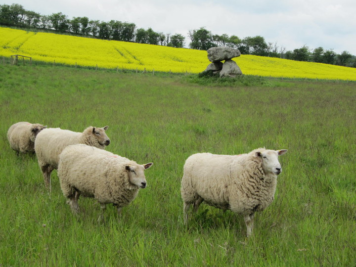
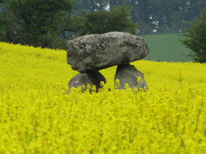
Devil's Den – 2nd August 2009 I should have posted this under field notes back in August, the day after Lammas when the sun was shining. As autumn sets in with the wind and rain its good to remember that sunny Sunday and Devils' Den. I didn't set out that morning to find the Devil's Den, only to participate in a 10 mile walk 'around Marlborough'. The person leading the walk lived in the small village of Fyfield so knew the area very well. It turned out to be the sort of day that is feels like a gift, sunny, warm with butterflies everywhere. When the walk-leader led us into a field of wild flowers, predominately poppies (apparently the second flowering this year) there it was on the far side of the meadow. To the best of my knowledge, Wiltshire's only dolmen, Devil's Den. I understand the field is now under Natural England's Countryside Stewardship Scheme so the dolmen is a lot easier to get to. I believe there was previously an issue about going onto private farmland. I had only seen Devil's Den once before and then only from a distance as I walked across Manton Down. It looked very beautiful in the sunshine and meadow of wildflowers in August. |
 Posted by tjj
22nd October 2009ce Edited 23rd October 2009ce |
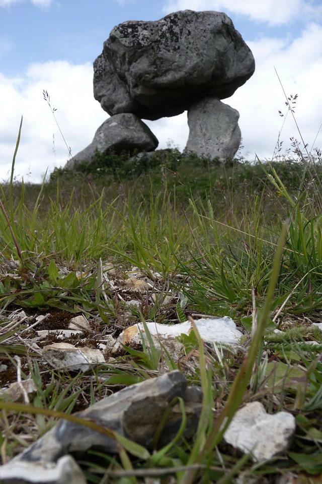
| Visited in July 2009 and found the site easy to access, though the base of the dolmen is quite overgrown. The surface of the field within about 8m radius of the dolmen is scattered with small stones and fragments of strange shapes and substances. Quite a few bits thin tubes of flint, some porous stone - or is it bone??? - and what looks like slag from very high temperatures. 'Tis devilry! |
 Posted by UncleRob
6th August 2009ce |
| I notice that the other field notes are several years old. I just wanted to add that access is easy now, through 2 gates. The field no longer keeps crops and is just covered in weed and stone. |
Posted by crazycraigee 19th April 2009ce |
|
Take out life insurance before visiting. The A4 is treacherous at the best of times, the track towards the dolmen can be sodden with deep puddles (even during the height of summer as my visit was) and if they don't get you the miserable farm workers will. Okay, I had crossed a field of crops, albeit down the tramlines. My overall sense of the dolmen was one of power. It looks as if it could crash down on the visitor; its size and bulk left me in awe of those who constructed the barrow that once stood there. |
Posted by Laughing Giraffe 10th February 2006ce |
|
Unlike just about everyone else on TMA, I declined to park on the A4 verge due to the madness of various daredevil drivers. Instead, we headed for the car park at SU159699, and I took a longer, leisurely walk along the bridleway at the opposite corner to the entrance to the car park. The bridleway is bounded on the left by a white topped, electrified fence. I didn't test to see if it was on, but after about 500 yards or so, the Den appeared on the near horizon. It seemed a long way away, and following the fence, I wasn't sure if I'd actually be able to get access, but the fence and bridleway headed left eventually, and down into the dale. A gate at the bottom of the hill led to the overgrown footpath, about 500 yards away from the barbed wire 'stile' near the stones. This last stretch was muddy, and I'd imagine could be quite overgrown in high season, unlike the lush grass track I'd taken thus far. The round trip took me an hour, and I'm not as fit as Moth, so it's probably a comparable distance, with no difficulty parking. The location itself is stunning, but I kept asking myself, 'why here?' Surrounded by hills on all sides, there is no obvious view or alignment for the 'barrow'. The stones lie on a distintive mound, but I suspect most of this is field clearance, as the restoration is is quite obvious, and the concrete was, for me, quite off-putting. I'll be back though, if only for the views from the approach. This post appears as part of the weblog entry Old and New Friends in Wiltshire
|
31st December 2003ce |
|
Access I think the gate at the bottom of the track opposite Clatford Farm is OK, but it could be a kissing gate. Think the main gate might've been unlocked anyway though (sorry, I don't seem to have had my useful-observation head on that day...!) The walk is not terribly long (15 minutes for me and I'm reasonably fit) but the track is pretty rutted and often very muddy. The final part of the path is overgrown (not too badly this time...) and access to the field is over a (low) bit of a barbed wire fence/stile arrangement, so not very handy! The dolmen can be seen fairly clearly but not closely from the path. Monday 15 September 2003 Nice to see the dolmen again, but without the strange (to me) chest high 'bean-like' crop it had in July. I do like this spot and could return again and again. It's such a short walk I'll probably come just about every time I visit Avebury! Worth reporting that in common with some others, my friend John felt that the concrete 'repairs' spoil the site. It doesn't really bother me that much. It'd be better if it had been done more subtly, but it's such a nice place and a wackily distorted dolmen that I still like it very much. This post appears as part of the weblog entry Moth flies south - part 1
|
30th September 2003ce Edited 1st October 2003ce |
|
After parking next to Clatford Farm, and crossing the busy A4, the delightful Jane and I finally made it to the small footpath that leads about a half mile into fields and the only true dolmen in the area. The farm track was quite overgrown and very muddy in places, so involved much scrambling along the verge, getting covered in chickweed and grass seeds, pricked by particularly tough thistles, and being stung by the abundance of nettles that grew tall and lush all about. A hare loping ahead of us, and a small rainstorm added to the experience rather splendidly. Finally, though, I could see over the verge top into a field of green, fat, waist-high wheat; and there, almost dwarfed by the landscape stood a wonderful dolmen. 'Dwarfed by the landscape' seems an odd phrase to use, because when this was originally a long barrow, it would have been huge. Clambering over the fence into the field, avoiding stingers, thistles, and barbed wire, we stood on a large stone, originally part of the barrow, that lay recumbent at the edge of the field. Following the 'tram lines' through the wheat, we made our way up to this magnificent dolmen. Hemmed in tight by the wheat, totally on our own, we were completely dominated by this wonderful structure, big enough that a megalither could sit inside it comfortably. I had to move back through the tram lines to be able to take a picture (difficult even with the wide angle lens on), and my trousers were soaked with the fresh rain that clung to the wheat. Not that it mattered. This place was magical, serene, and spellbinding. I don’t know what it is about Wiltshire, but it’s the one place in this country that I feel so very close to the Goddess and the whole Mother Earth belief. Not that there aren’t others; but this place just emanates it in all-embracing waves. We rested by the dolmen, reluctant to leave. I found a small, flat, squarish piece of flint on the ground, just the right size to use as a base for burning a vanilla cone. Lying it on the dolmen, I sat inside and let the smoke waft past, feeling wonderfully safe under the massive, softly rounded, three-foot thick capstone. It was like sitting in the heart of the stone, a symbolic womb. They certainly knew what they were about, these Neolithic builders. After a while, we had to leave, and sadly we made our way back down the path, yet enriched by the vibe offered by the ‘Devil’s Den’, a misnomer if ever I heard one. It’s certainly a place I would like to return to in winter, or when there isn’t quite so much arable in the field – although wheat is such a symbol of fertility and abundance, perhaps it was entirely the appropriate experience. |
31st August 2003ce |
|
Sunday 27 July 2003 As Julian suggests in the big papery TMA, I parked on the left of the A4 at the entrance to Clatford Farm, on the verge in front of the farm sign on the west side of the entrance. I had to take care crossing the busy road to the beginning of the track at map ref SU158688. After about 15 or 20 minutes the Devil's Den came into view near the bottom of the gentle slope up to the left. As vegetation was thick, I missed the path where it forks left from the track 20 yards or so before the dolmen. The path itself was fairly overgrown and the dolmen in crop. I slowly and gently made my way through the crop. Judging from the mess in places though, I guess others hadn't been quite so careful. I love dolmens (!) and this dolmen is everything I expected, despite the slightly dodgy restoration or repairs. Having not visited France, Ireland, Wales, Cornwall or Devon for some time, it felt quite odd to be looking at a dolmen. But good! Photographic opportunities were limited by the thick crop, but I enjoyed the peace of the site and felt fortunate not to be disturbed. As I walked around the dolmen a couple of times with my camera, its positioning in the valley seemed unusual, as I now see Rhiannon has remarked on this site. It's placing did however remind me slightly of Lambourn Seven Barrows that I had visited the day before. This post appears as part of the weblog entry Glos 'n' Oxon, Picnic People & Stomping in the Sun - Part 3
|
5th August 2003ce Edited 6th August 2003ce |
|
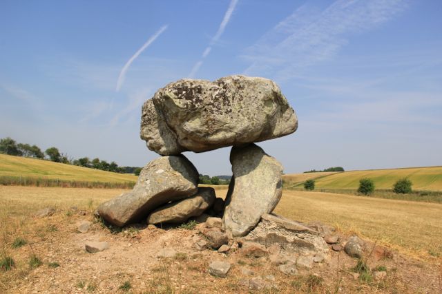
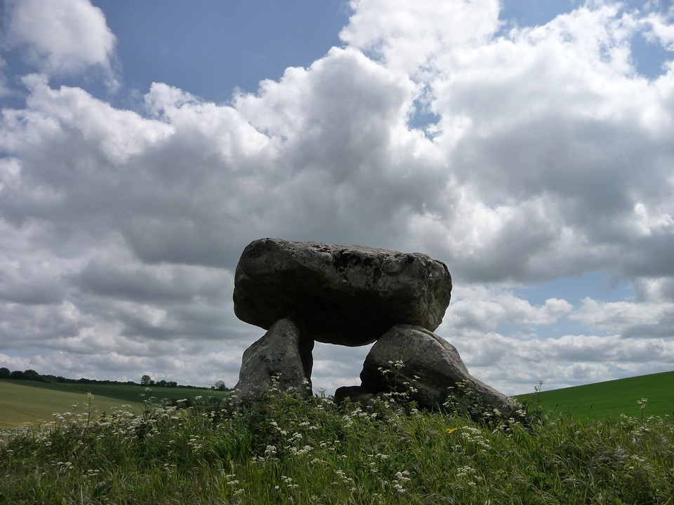
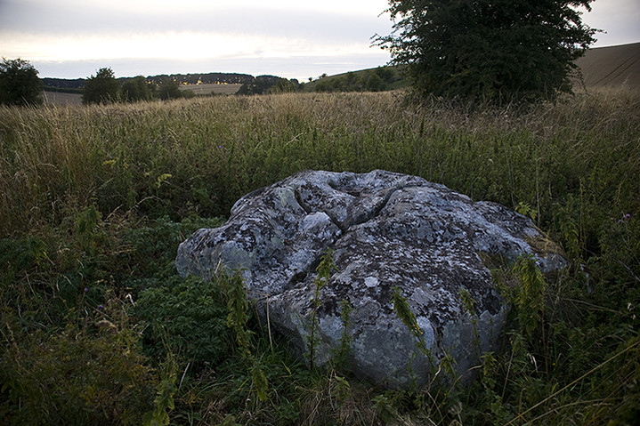
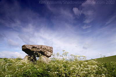
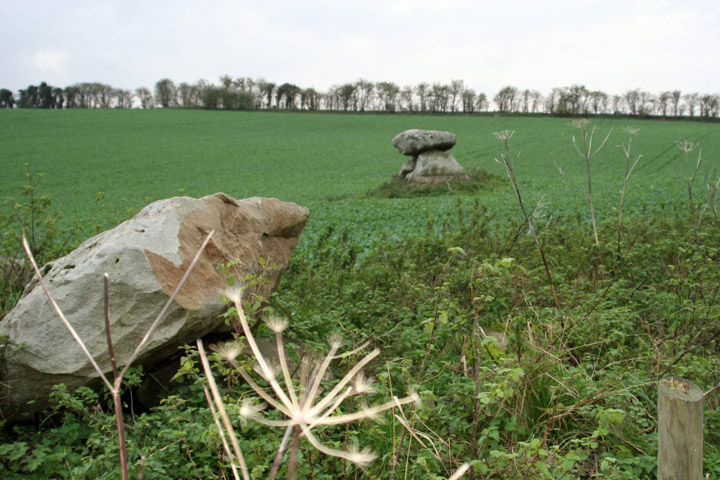
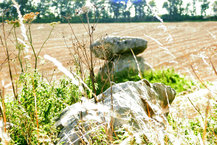
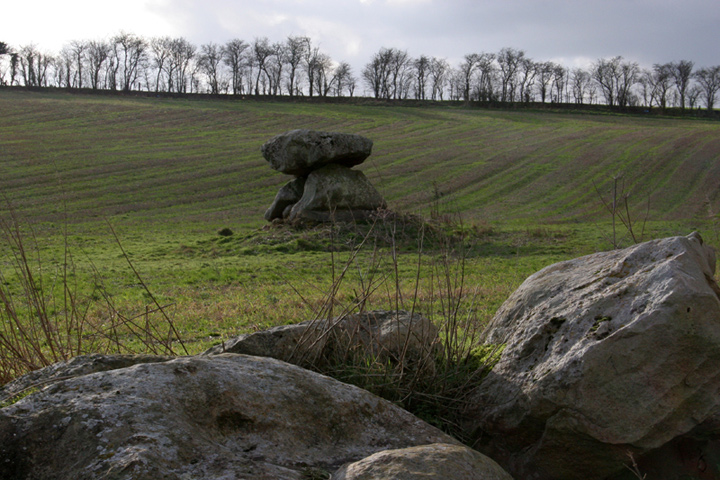
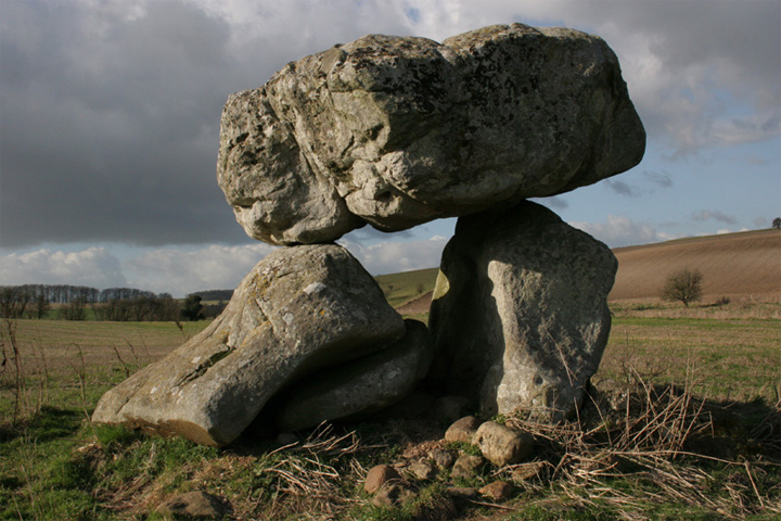
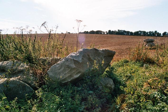
Well worth a visit if you have arrived at Avebury during rush hour, and could do with connecting to the past and the environment and would like to have a one-to-one experience. If you want to touch the dolmen, you will have to trespass. Although I have the utmost respect for St. Julian, the MA is quite selective at times regarding condition of sites. This dolmen has some spectacularly intrusive restoration, in particular the large concrete slab which shores up one side of the base of the monument, and that it was re-erected according to Dyer 'Discovering Prehistoric England' in 1921. That said, it is a beautiful, and peaceful location. From reading the posts on this site and my own experience of trying to find a footpath nearby where the land owner(s) had left an overgrown unwalkable 12" death-strip between two barbed wire fences as a sorry excuse for a public right of way, access to our heritage is not high on their agenda. All that is there now are two uprights and the enormous capstone. On the footpath which runs alongside the field containing the dolmen are several very large stones, which are almost certainly those featured in Stukeley's illustrations from the 1720s showing the dolmen with 3 to 4 other large stones around it. We stood on the one nearest to the barbed wire fence to get a better look at the dolmen (and possible landowners) and discovered that some delightful soul had thoughtfully cut away a section of barbed wire. The precariousness of the capstone is wonderful, even though upon closer inspection it is concreted to the supports with no attempt at subtlety. No hint of the earthen long barrow remains. Stukeley's illustrations show the stones set upon a mound, but this is no longer visible. Intriguingly the site hasn't been excavated, but it has been plowed level for so many years now I'm not surprised. |
Posted by elderford 29th September 2002ce |
|
Visited this site for the first time at the weekend. A sorry admission since I spent 18 years of childhood and youth in Swindon a few miles up the road and was a regular visitor to the Avebury henge and environs during that time. Harvesting was well underway this weekend. Whilst walking up the field boundary to the dolmen, a farmer, presumably Kommisar Clatford, drove headlong towards (to the untrained eye damaging his own crops whilst doing so) to remind us that we were on private property. This is the field that Evelyn Francis, in her cute Avebury Wooden Book, suggests should be dedicated to St Pesticide. Mmm. This farmer was angry as hell and pompous as well. Deja vu at the Devil's Den. This was all too much like our recent experience in Cork and Kerry. I explained that little boys in shorts and 4 foot high stinging nettles don't make for a happy day out and he responded that that wasn't his problem. I enquired as to whose responsibility the management of the public footpath was and we then had a really fascinating exchange of opinions about the rights and wrongs of permissive access to national treaures. After a sincere empathetic recital of the country code on my part - a useful skill I picked up when having a similar chat with a Corkmam farmer a few weeks ago - he gave us permission to walk on to the dolmen. His summing up, concluded "Technically no-one should be allowed in here as it [the Dolmen] is on private land. Still I suppose some people are better than others". Not sure what to make of that but I resisted the temptation to say the same thing to him! This encounter detracted somewhat from the experience of visting this most un-Wiltshire-like place. More like the Dorset Hellstone than say, Devon's Spinster's Rock, this gnarled little specimen was a nettly oasis from the Combine Harvesters which surrounded us. I wasn't AS "moved" as others have clearly been here (but then my heart and soul really belongs to Gurranes) and was surprised to note the large slab of concrete holding the edifice up on its eastern side. Still a wondrous place mind you. |
3rd September 2002ce |
|
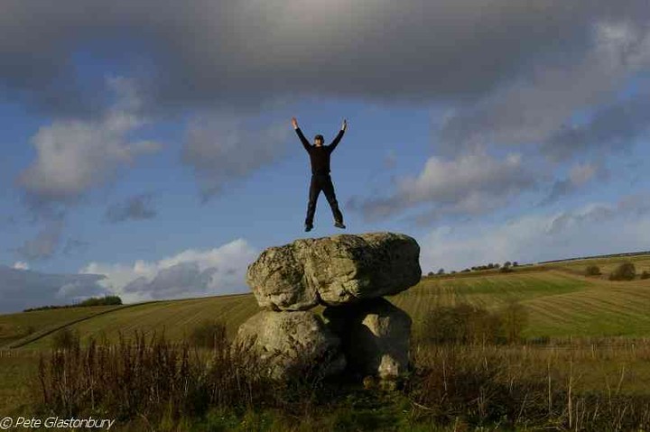
Well, well, how this place haunts the soul. A trip down to the Marlborough Downs in May with the sprogs was specifically to visit some of the stuff outlying Avebury. After a significant detour (which had my 8 year old son whinging for England) my 12 year daughter spotted it way off in the distance in the hidden valley below the ridge which we were straining to climb. Retracing our steps, we finally reached it and were surprised at how big it was. WE stayed for some time, the little lad enjoying making 'mini-Devil's Dens' from rocks lying around. Less than 5 weeks later, on 21 June, me and the very talented Treaclechops bowl up at the place and chill out there for a while. After the hurly burly of a midsummer day's Avebury, we had the place COMPLETELY to ourselves. Which was nice. |
 Posted by Jane
18th July 2002ce |
| Having parked the car on the verge (my rookie boyfriend: 'Isn't there a car park or something' hoho but he is keen and in training) and negotiated the mud in my unhelpfully flared trousers, turned the corner at the barn to spy the dolmen perching in a lively manner in its field. Seems strange to be in the valley - but what a top spot. Just as we approached the farmer drove between us and it with his tractor spraying christknows what over the wheat(?). I didn't feel that paranoid about the prospect of skipping over his crops in full view, but what I didn't fancy was the thought of the vile stuff he'd just sprayed wafting all over me in the process. As boyfriend remarked between coughs, it smelt like scampi fries. Could have been merely fertiliser I suppose but whether liquid fish or organophosphate it certainly set us to thinking about the state of our food and how although an organic loaf doesn't look so different it probably contains quite different chemicals. But anyway. The devil's den was fantastically quiet (a world away from Avebury) and I am determined to come back to experience it properly very soon. The setting is perfect; it must have looked fantastic surrounded by flax. |
 Posted by Rhiannon
25th March 2002ce Edited 15th November 2007ce |
|
I visited here for the first time on my 30th Birthday (end of October 2001). I have been to avebury area at least once a year since my 21st and it has become a bit of a pilgrimage but, until buying the Modern Antiquarian, I had never even known of the existence of this amazing dolmen - thanks Julien. The short walk from the A4 was hazardous due to deep puddles (well - lakes almost) to negotiate whilst holding on to my partners arm (she never has been able to trust her own sense of balance) and I was desperately hoping for better surroundings for the Dolmen - I had pictures to take for a forthcoming Exhibition. The weather was perfect - large storm clouds drifiting across a bright blue sky with typical long autumnal shadows and things seemed to get better and better as we rounded the corner in the path by the barn - the puddles dissapeared and the soft roll of the downs came into view. As soon as the Dolmen was visible, I was speachless (unusual for me). I could not have wished or hoped for a more perfect setting for such a magical place. I spent about 20 minutes walking round, looking in and just absorbing this beautiful place. My partner sat on the large sarsens in the undergrowth at the edge of the newly ploughed field (part of the original structure or just field clearance? - the former and latter I expect) while I spent well over an hour setting up and photographing - desperately trying to capture the atmosphere and mood of the time and place. The field was strewn with flint litter and I found several waste flakes while walking the short distance between the fence and Dolmen - one to remember for field walking if the farmer is in agreement. Unfortunately I used poorly cleaned equipment to develop the negatives and have all but ruined my shots (perhaps the site punishing me for daring to begin to think I could do it justice with such modernity and technology) - I dont care though because I have found the most impressive place to visit in the Avebury environs and will spend many a peaceful birthday there in the years to come. |
 Posted by wayland
19th November 2001ce |
|
I visited this site after discovering Silbury Hill to be fenced off and since I was in desperate need of solitude and peace, Devil's Den is ideal. I found the best way to actually reach the site is to follow the path along the side of the field until it tails off to the right. At this point follow the walked track through the plants (it was August) next to the field until you reach the closest point to the dolmen. The stones seperate from the Dolmen that Julian talks about in TMA lie here and the fence is usefully mutilated allowing easy passage. The site itself is stupendous. I lay for an hour on the stone recollecting myself. I would recommend this site to anyone. |
 Posted by juamei
30th August 2001ce |
|
EXCITING !!!!!! WOW this really took my breath away!!! This was the first trip to the Avebury area that I had Julians book with me and was determined to use it in order to find Devils Den. Parking was a bit of a nightmare, and the road a bit on the dangerous side, however once the road has been crossed you are well on the way to something special. My 65 year old Mum seemed as excited as me as we walked up the track toward the site. Suddenly I could see it, just above the brambles, tall grass and various plants. I screamed with excitement and left mum behind trying to catch up..... For a while I couldn't see how I was going to get inside the field and almost began to think there was no way. However after a little bit of searching I found a small clearing and jumped over the fence. Mum and I stood in awe of the fantastic site. (it reminded me of Kits Coty a bit, apart from the fact that this lucky site wasn't behind bars.....) The huge cap stone is balanced so precariously that you wonder if you touch it whether it will fall!! The atmosphere all around is kind of strange and there didn't seem to be a sound of anything whatsover, just silence. The field surrounding this site was a strange copper colour which added to the ambience. I took many photos and spent a long while hear taking in every detail. I was interested to see the hollows in the top of the dolmen Stone which Julian mentions in his book, talking about the water and the devil....... it was said that if you "poured water into the hollows of the roof-stone it would always be found drained to the last drop in the morning by some demon..." Go visit and enjoy this site, I will return again in early March... |
Posted by pussie 14th January 2001ce |
| Parking was a pain but verges are great. I always feel guilty about 'quick stopping' these sites but we stopped off on the way back from Avebury. The walk was muddy even in July (I'm catching up on my reviews). So much so that my mum and daughter dropped out to go and sit in the car. Wifey, Son and I carried on (3 generation family stone outing) , it kind of added to the pilgrimage feel. By the time we got to the stones, Deb and Tommy were content to view from the gate. I carried on and got some great pics. I'll scan them in one day and post them. The flax was out and the field looked like a lake. Dead cool. |
 Posted by dickie
27th August 2000ce |
Folklore |
|
It is naturally the subject of many legends in the district, and few, we imagine, of the people about would care to find themselves too close to it at the solemn hours of midnight, though one of the stories necessitates such a state of things; for we were told that if any one pours water into any of the natural cup-shaped cavities on the top stone at midnight, it will always be found in the morning to be gone, drank by a thirst-tormented fiend; while another of the local stories tell us that as twelve o'clock arrives each night Satan arrives with eight white oxen, and vainly endeavours to pull the structure down, while a white rabbit with fiery eyes sits on the top stone, and aids matters by his advice and general encouragement of the proceedings. Another belief is that if a good child walks seven times round it nothing in particular happens, but that on the seventh revolution of the bad boy or girl a toad comes out and spits fire at them. This legend has probably been constructed by some posessor of ne'er-do-weels, as a sort of bugbear or bogey to hold over them, in the same way that our immediate ancestors were scared into propriety by the terrors of "Boney," and its efficacy having been proved, it has been incorporated in the mass of beliefs floating in the rustic mind. The examples given are only a very few out of the many stories associated with this ancient pile.From p121 of 'Town, College and Neighbourhood of Marlborough', by F E Hulme (1881). |
Posted by Rhiannon 23rd August 2012ce |
There are various traditions connected with it. I was told some years since, by an old man hoeing turnips near, that if anybody mounted to the top of it, he might shake it in one particular part. I do not know whether this is the case or not, though it is not unusual where the capstone is upheld by only three supporters. But another labourer whom I once interrogated informed me that nobody could ever pull off the capstone; that many had tried to do so without success; and that on one occasion twelve white oxen were provided with new harness, and set to pull it off, but the harness all fell to pieces immediately! As my informant evidently thought very seriously of this, and considered it the work of enchantment, I found it was not a matter for trifling to his honest but superstitious mind; and he remained perfectly unconvinced by all the arguments with which I tried to shake his credulity.An atheist might find the latter section quite ironic, coming from the Rev. A C Smith as it does. It is part of his (excellent) 'Guide to the British and Roman Antiquities of the North Wiltshire Downs' (1884). |
Posted by Rhiannon 13th March 2006ce |
|
It's no good - farmers with all their horses chained up to the stones just can't shift them. Besides this would deprive a demon of his breakfast - if you pour some water into the depressions on the top slab you can guarantee that some fiend will have drunk it by the morning. At midnight the Devil yokes up 4 white oxen to try and mve it - and even he can't. (Why he wants to do this when it's his own den I don't know). A great white dog watches them from under the capstone, with eyes like burning coals. Or perhaps it's a giant white rabbit with similar eyes (or a hare? - that seems a bit less soppy?). White animals (with red ears) generally come from the underworld in Celtic mythologies. (these stories in 'Folklore of Ancient Wiltshire' by Katy Jordan) |
Posted by Rhiannon 1st May 2002ce Edited 13th March 2006ce |
Miscellaneous |
|
|
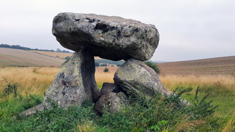
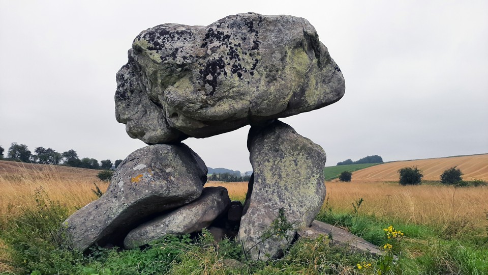
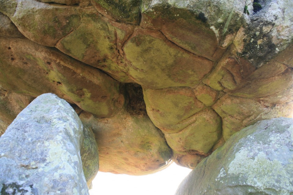
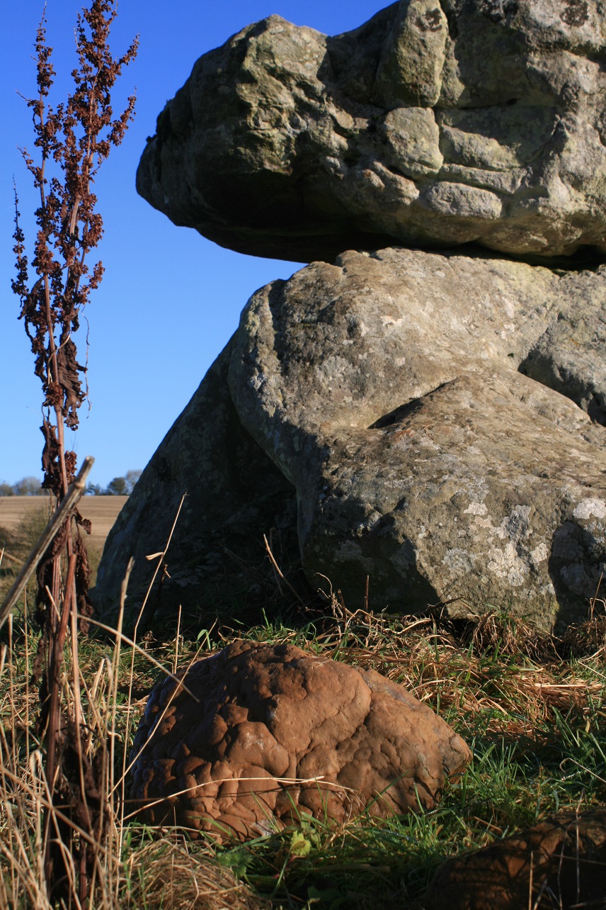
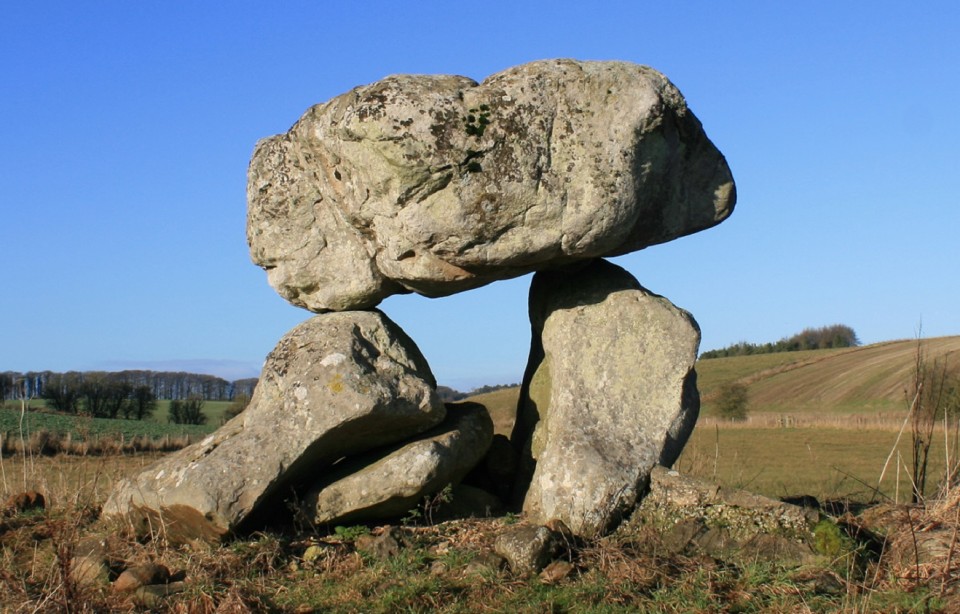
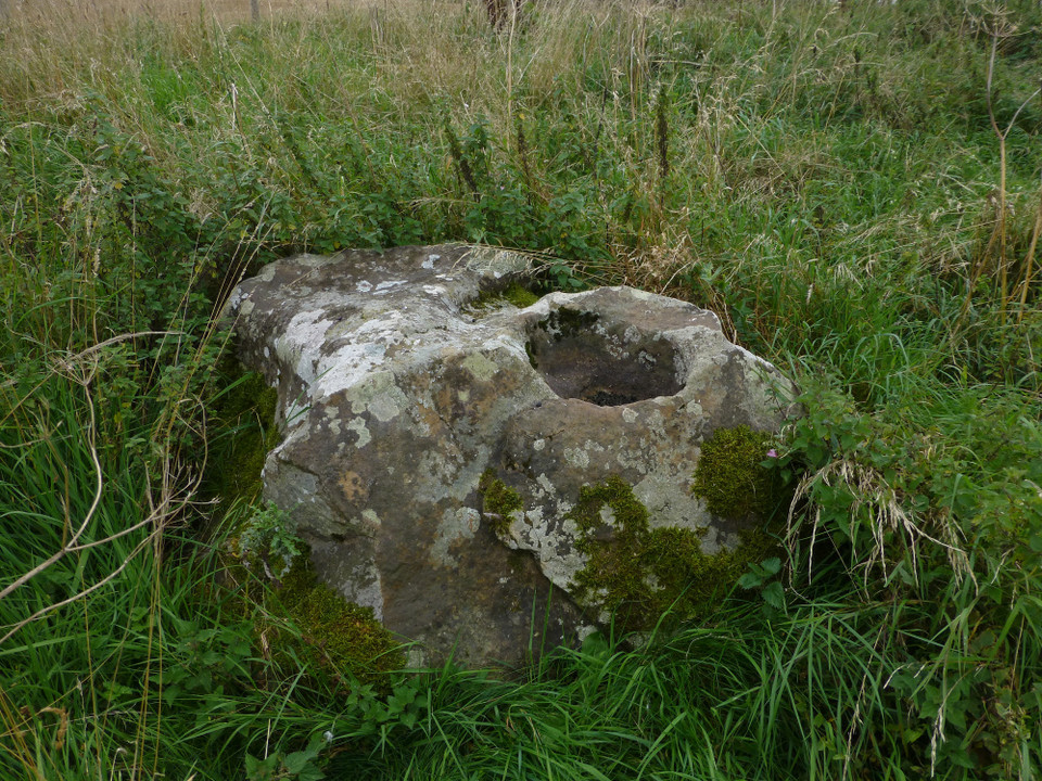
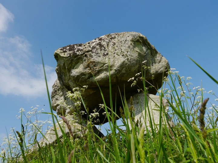
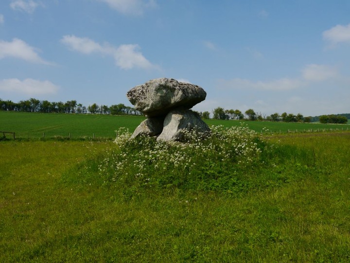
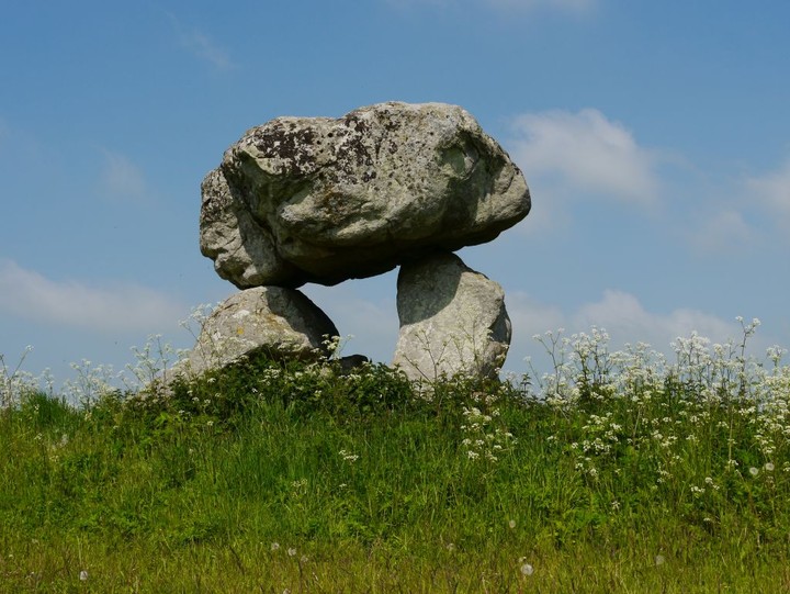
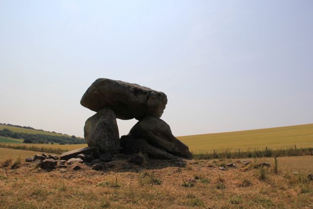
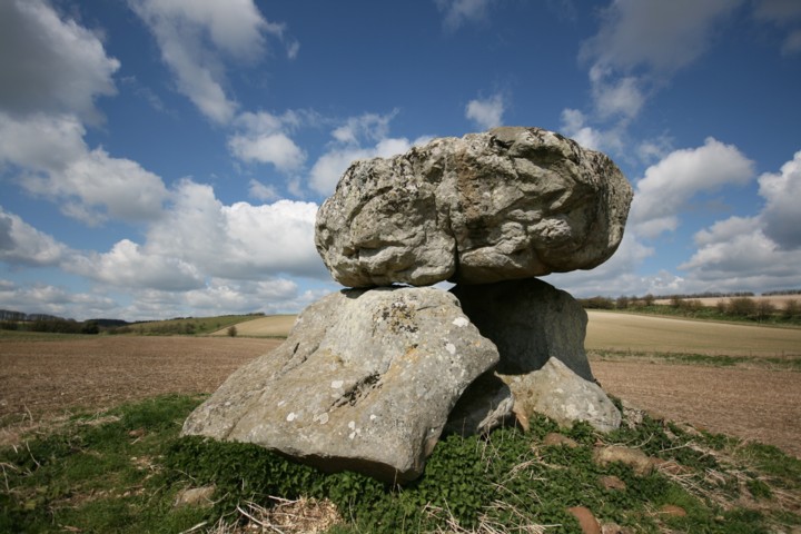
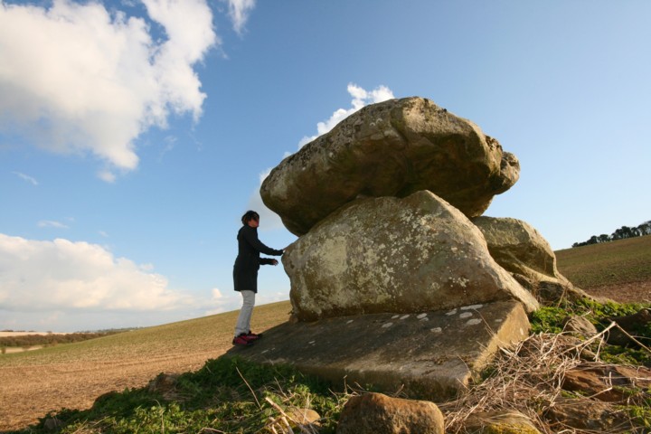
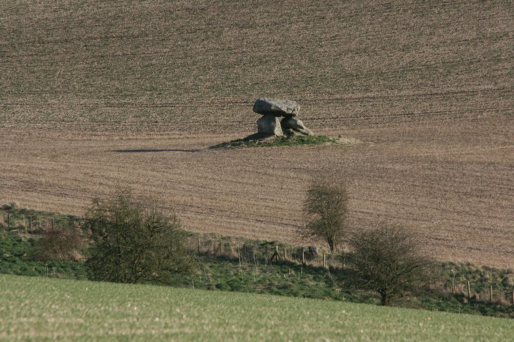
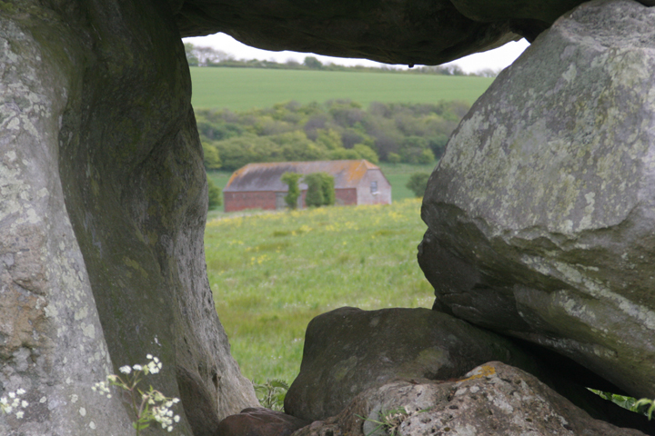
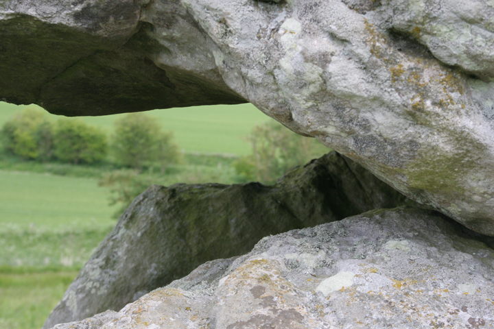
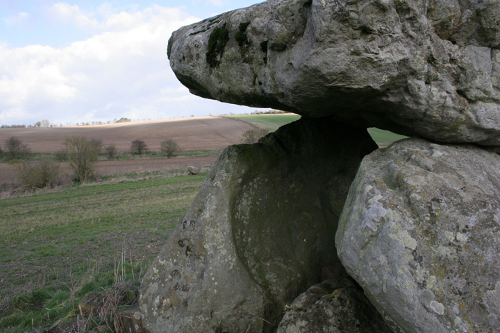
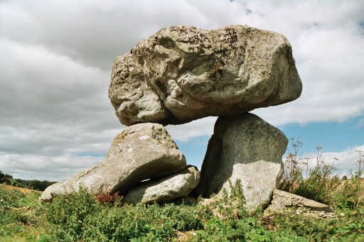
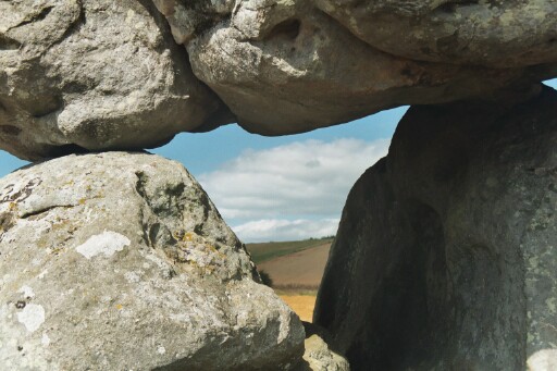
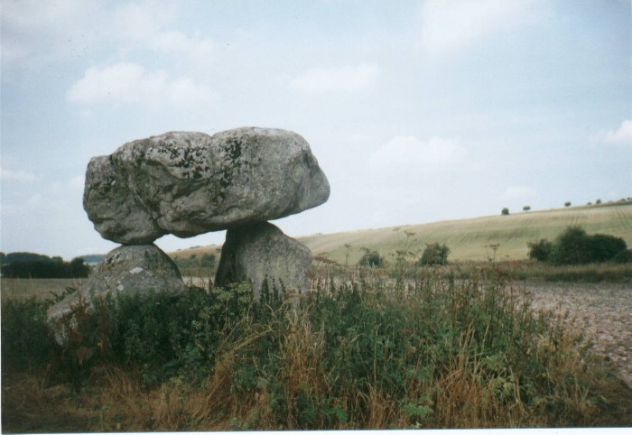
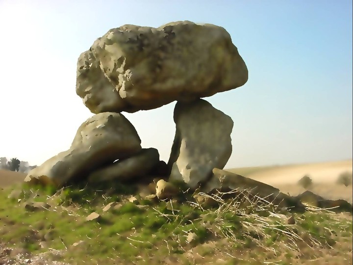
Details of site on Pastscape (SU 15206965) Devil's Den (NAT) Burial Chamber (NR) (1) Preshute 3a; Long barrow, destroyed except for ruined remains of chamber, re-set 1921. Orientated SE-NW, with larger end to SE. Assessed by Passmore to have been 230ft x 130ft; there may have been a forecourt originally. (2) In 1921 the remains of the barrow were much spread and lowered by ploughing but still visible. The chamber was about 70ft inwards from the larger end. (3) 'Devil's Den' (name confirmed and in local usage) is situated at 450ft OD, in arable, at the bottom of a broad shallow coombe. The NE upright stone, supported at its outerbase by concrete, is 3.0m long, that on the SW is 2.6m long and leaning; both enclose an overall ground width of 3.6m. Height to top of capstone approx 2.5m. Two large fallen sarsens within the chamber possibly represent end stones, and a further 16 (? field clearance) sarsen fragments lie within the interior. The chamber, which remains in good condition rests upon a grass covered mound, diameter 7.6m, height 0.8m. All other ground spread of the barrow is now ploughed out. Divorced survey at 1:2500. (4) The mound was mapped at 1:10,000 from APs by the Fyfield Down and Overton Mapping Project. No further information was recorded. (5) |
 Posted by Chance
31st October 2012ce Edited 31st October 2012ce |
|
SPIRAL PATTERNS IN THE EARTH In the 1930's Reginald Smith was regarded as the leading authority on the Neolihtic Age and Keeper of the British and Roman antiquities at the British Museum. He discovered that all long barrows and the centres of certain stone circles, were all set over an underground water source. The late Guy Underwood confirmed and continued Smith's work and surveyed the Devil's Den in 1958. [It's a shame I can't include this amazing survey here.] Underwood detected, through the medium of dowsing, that the dolmen was set over a powerful blind spring. Blind springs generate a surface spiral pattern [known as a geospiral] and it is this energy which dowsers detect. The Devil's Den has one of the most intense and powerful geospirals in the county. Interesting to note that most of todays knowledge regarding the 'geodetic system of earth energies', came from open minded field archaeolgists such as Smith and Underwood, and today most archaeologists shy away from talk about ley lines and earth energies. |
Posted by Maria 2nd May 2003ce Edited 2nd May 2003ce |
|
like three shredded wheat piled up on high took ages to find you through the overgrown nettles hands held high darren saluted you be back soon map of human's aspiration as above so below stone curbs ebb and flow |
Posted by mindweed 9th April 2002ce |
Links |
|
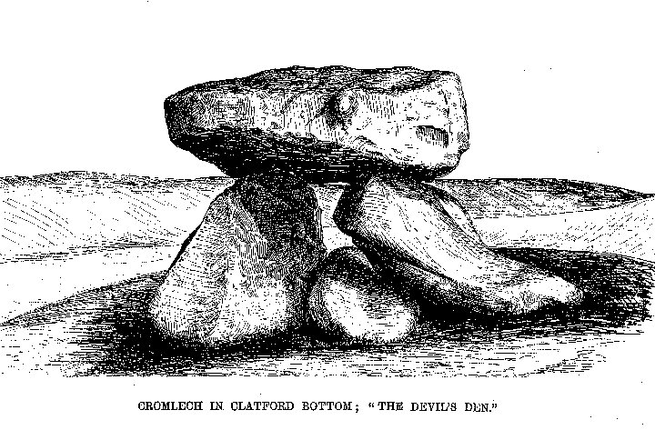
Avebury - A Present from the PastStukeley's illustration of the Devil's Den: "The Kist-Vaen in Clatford Bottom". One of a number of views of the site in 'Abury - A Temple of the British Druids' (1743), online courtesy of Lithop. |
Posted by Rhiannon 28th June 2006ce |
Read Book OnlineThomas Hardy set his short story 'What the Shepherd Saw' at the Devil's Den (or the Devil's Door, as he called it). "To the south, in the direction of the young shepherd's idle gaze, there rose one conspicuous object above the uniform moonlit plateau, and only one. It was a Druidical trilithon, consisting of three oblong stones in the form of a doorway, two on end, and one across as a lintel. Each stone had been worn, scratched, washed, nibbled, split, and otherwise attacked by ten thousand different weathers; but now the blocks looked shapely and little the worse for wear, so beautifully were they silvered over by the light of the moon." |
Posted by Rhiannon 4th October 2005ce Edited 6th January 2010ce |