spencer

spencer

All posts expand_more 351-400 of 708 posts
Image of Ecclesall Woods (Cup and Ring Marks / Rock Art) by spencer

Ecclesall Woods

Cup and Ring Marks / Rock Art

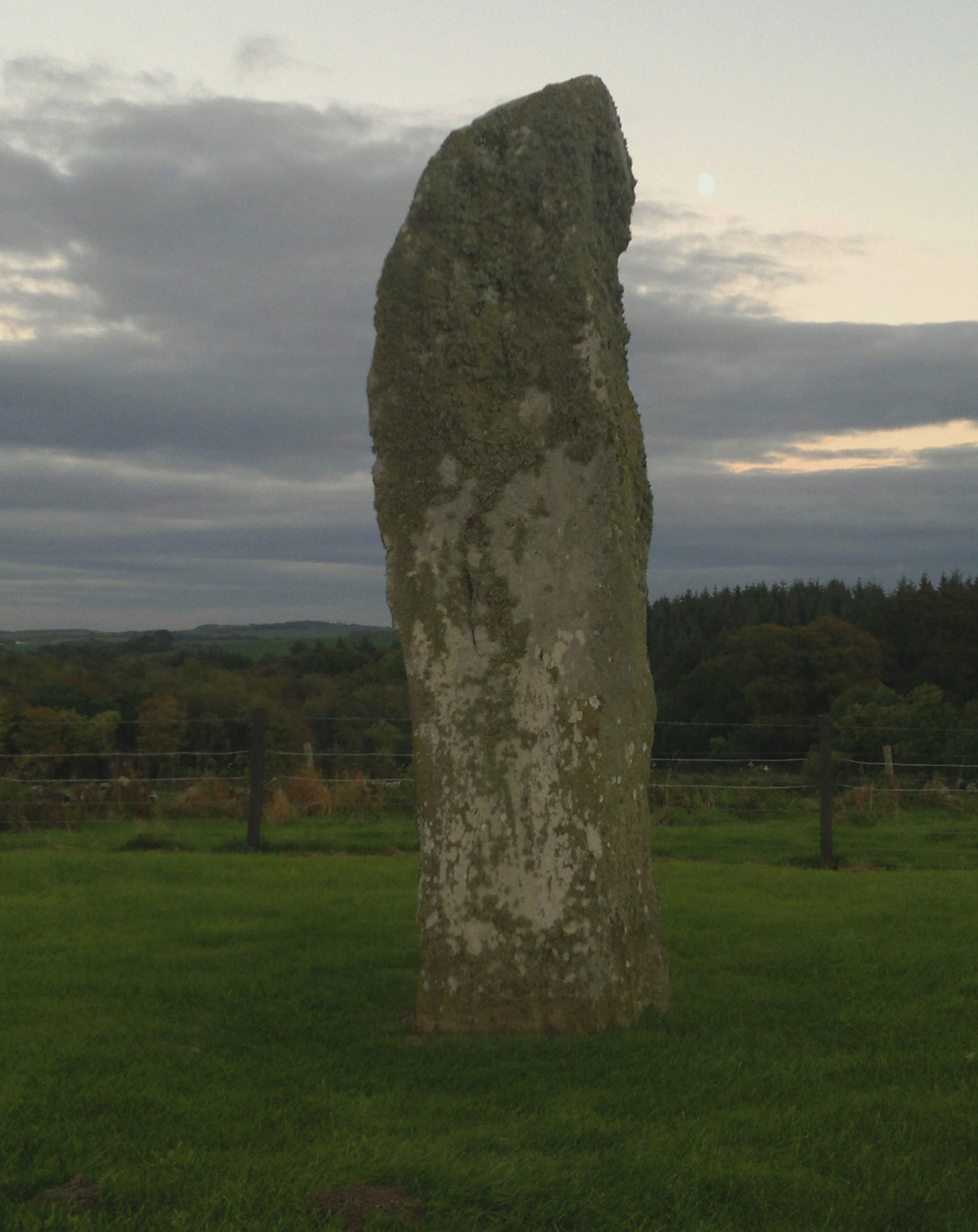
The hidden gem in a city wood. I d o love this stone..it knows what I think. The moss is growing back. Please let it. I wish I could put do not disturb signs on the footpaths nearby, but that would only encourage the oppsite. A quiet treasure. And a photograph of it would make a lovely front cover for a book....but no image details within. Please, only go if you need, not want, OK?

Image credit: Mike Purslow

Link

Scotland
Country
shoreUPDATE

The interactive website of SHARP, Scotland’s Coastal Heritage At Risk Register. News, events, interactive map of the 940+ sites at highest risk. Report via it any deterioration. A useful and worthy resource. Some of those sites may undoubtedly be yet to added to TMA too.

Link

Orkney
Orkneyjar Archaeology

What it says...there is already a link for Orkneyjar, tucked right down at the bottom of the page, dated from 2001. That covers a different part of the website, the ‘history’ bit. Sixteen years on the archaeology section has grown into an invaluable resource, and deserves to be at the top of the links and the first port of call for those visiting TMA interested in Orcadian archaeology. I therefore hope that this ‘sort of relink’ will be allowed to stand.

Miscellaneous

Knowe of Skea
Chambered Cairn

I hope TMA Eds will forgive me adding a site I may never visit, but from what I have read so far it is a very intriguing place, little known, which may prove to be of considerable importance, and would appear to be in part contemporary with Ness of Brodgar. A tomb of unusual size. See also the separate eponymous entry for the nearby Iron Age part of this complex, and the link within it.

Miscellaneous

Knowe of Skea
Iron Age Shrine

This lies due north of the of the earlier and unusually large sized chambered tomb for which there is an eponymous but separate site entry. An underpublicised complex of importance. See link below for excavation details, and read the Canmore entry linked to the chambered tomb.

Image of Carl Wark & Hathersage Moor by spencer

Carl Wark & Hathersage Moor

Sunset above Carl Wark, seen from Burbage. They’ve gone, so have a fair few of the stones..but the sky remains. They saw sights like this, and now do we.

Image credit: Mike Purslow
Image of Torhousekie Stone Row by spencer

Torhousekie Stone Row

Stone Row / Alignment

Five minutes before taking this photograph while returning to the road after finishing my site visit I was charged by a herd of about twenty cows. Unknowingly I did the right thing, stood for a minute afterwards, then walked to the gate, but then turned and returned to the stones as I wanted to show the cows that they had not won, laid down in the grass, took out my old mobile phone instead of my usual one and pointed it. This was the result. I do not need to go back.

Image credit: Mike Purslow

Link

Greadal Fhinn
Chambered Cairn
Heritage Ardnamurchan

The archaeological section of the new website of the Ardnamurchan History and Heritage Association, listing all known sites, which will be added to as and when their members fieldwalking discovers them. Much to visit already that is officially notified but not as yet on TMA or elsewhere.

Image of Ox Stones (Natural Rock Feature) by spencer

Ox Stones

Natural Rock Feature

My conviction that these stones have been a waypoint and place of congregation for millennia on the ridge that leads to Stanage is absolute. From this angle the right hand stone becomes ravenlike. Look: it even has an eye...

Image credit: Mike Purslow

Link

Greadal Fhinn
Chambered Cairn
A Kilchoan Diary

An article with fine photographs of and information about Greadal Fhinn which also contains a link within it to more of both..as well as a photographic description of what you will see if you visit this site and then keep walking and climbing westward in this most majestical and starkly beautiful hidden corner of Scotland.

Crammag Head

A return a year after my first visit, and I found that the replacement of the power line and the poles that carry it has caused fresh damage to the cliff to cliff earthwork that encloses the dun, which is believed may be an earlier structure. See photo. When the light was replaced a few years ago there was a watching brief on the work. Sadly, times seem to have changed..

Image of Cairn Macneilie, Inch Parks (Cairn(s)) by spencer

Cairn Macneilie, Inch Parks

Cairn(s)

The top of the cairn, stone, some moss covered, visible amongst fallen leaves. Depression at right of image may indicate at least an attempt at robbing, or perhaps the site of a fallen tree.. Canmore uncertain

Image credit: Mike Purslow

Tree Island, Whitefield Loch

This site is no longer an island due to a fall in the level of the loch. It is unmarked on OS 82, but delineated by a cairn symbol on Explorer 310 on account of the spread of stone atop it. Access is from the fisherman’s car park at NX 235 549, from whence paths radiate, then beating your way through the brush. Canmore ID 62149

Image of White Loch of Myrton (Crannog) by spencer

White Loch of Myrton

Crannog

The reflection of the SE side of the crannog in the loch, the setting Sun shining through the trees that enfold, conceal but demarcate it (ATTN EDS pse remove my other ‘artistic’ image, mistakenly uploaded : ) )

Image credit: Mike Purslow

Link

Droughduil
Artificial Mound
Dunragit Excavation

A summary of the Manchester University excavations at Dunragit in 1999-2002. Top photograph shows the excavation of Droughduil’s W side. Another photo shows the excavations of the wooden Dunragit circle and triple concentric cursus, with the interlinked Droughduil, believed a viewing platform, in the background.

Image of Droughduil (Artificial Mound) by spencer

Droughduil

Artificial Mound

The view looking NNW from the top, which is an early Bronze Age cairn built on top of the late Neolithic remainder. The pale green field top right contains unexcavated features ID’ by aerial photography inc a wooden posthole avenue. Beyond the field – the L-R hedgeline is the railway to Stranraer – is the site of the wooden henge and 300’ m dia tri-concentric wooden cursus excavated in 1999-2002. Droughduil itself was excavated in ‘02, and was shown to be a probable contemporary viewing platform for the 2500 BC cursus.

Image credit: Mike Purslow

Drumtroddan Standing Stones

Yes, I know I’ve wrongly uploaded a Cairnholy pic ..can’t remove. (Eds?) Nor, he neatly sidestepped, the memories of visits to Drumtroddan. One of my ‘evening’ sites that suit that time of day. Night comes in, sun fades in the west. The stillness, the manicured grass island wherein they stand and lie, the horizon, the lichen. The two that lie.... perchance they sleepeth. One is on guard, slender but imutable, in profile in mourning for the fallen. Barsalloch mid October for the late afternoon bask, then here. Turn back and look when you get to the gate at the road. That head will still be visible against the fading light, still bowing, this time to you. Reciprocate. Try to return.

Image of Cairnholy (Chambered Cairn) by spencer

Cairnholy

Chambered Cairn

Yes, tweaked rather, but, on some autumn evenings there w i l l be a blazing sunset behind those stones. Try to experience that here, as well as Torhouskie. To get the best photographs of this place lie down.

Image credit: Mike Purslow
Image of Dunman (Cliff Fort) by spencer

Dunman

Cliff Fort

2016: Dunman, the Hall of the Gables, still unattainable... a fence and a cliff requiring new route, plus cattle and health...but is there a finer positioned Iron Age fort in all Scotland? Just look at it. Totally, utterly magnificent.

Image credit: Mike Purslow