Craddock Moor Stone Circle
Image credit: Roy Reed
Craddock Moor Stone Circle

Craddock Moor Stone Circle

Craddock Moor Stone Circle

Craddock Moor Stone Circle

Craddock Moor Stone Circle

Craddock Moor Stone Circle

Craddock Moor Stone Circle

Craddock Moor Stone Circle

Looking across the stone circle towards Tregarrick Tor.


The southern arc, still keeping its head above the turf after being cleared a couple of years ago.


Northwestern arc.

Northern arc.

Southern arc, looking southwest towards Tregarrick Tor. There a several cairns on the ridge ahead.

This could be a wonderful circle if sympathetically re-erected.

Western arc, Brown Willy on the centre skyline.

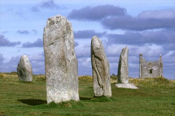
Southern arc. The Cheesewring and Stowe’s Pound are prominent on the skyline.

Approaching the circle from the WSW.

A merge of three photos taken on the morning of the autumnal equinox. Didn’t have enough of us to stand on each stone..but gives some idea of the layout.

6th January 2004

The Craddock Moor stone circle

September 2004...before the mist closed in!

Nice shaped stone at south east of circle

The large gorse bush roughly marks the centre of the circle.
The mushrooms in the foreground seem to grow in abundance in the area!

Stone shows signs of being worked.

Tregarrick Tor in the distance.

june 2003

I was pretty determined to spend ‘Christmas Day’ 2002 on a wind swept moor amongst ancient sites, and I managed to do just that.
I started with a quiet drive to the most famous quoit in East Cornwall, the huge Trethevy Quoit. I had seen it so many times in pictures; it was great to see it for real.
I moved onto toward the Hurlers but not before stopping at The Longstone Cross / Long Tom Cross. It may have once been a menhir that was then Christianised by carving a cross on its face. The stone stands alone, often amongst sheep roaming the moor, and on the horizon a line of old mine chimneys can been seen, marking the lode (course) of a copper vein. Even on this day there were lots of walkers and doggie people around The Hurlers, which was nice. It’s good to see people taking an interest (even a passing interest) in our history. Not only are the circles fascinating, but the whole place is steeped in history, from the Pipers, Rillaton Barrow, the Cheesewring, Stowe’s Pound, and Craddock moor sites, to the plethora of old mining ruins.
Without a map or compass you may be lucky enough to stagger across the fallen Craddock Moor Circle 1 km North West of the Hurlers whilst exploring Craddock Moor. Even with a map and compass you may not find them as the stones are all recumbent and are not visible from any distance. Further on is the tiny Craddock Moor Stone Row. There’s no easy way to describe how to get to this but if you wanna go try my instructions (or practice better compass reading that me – not hard!).
A few kilometres away from the Hurlers area, King Doniert’s Stone(s) stand in a beautiful walled enclosure, complete with stone benches. The Cornwall Heritage Trust could obviously teach English Heritage a thing or two.
I love ancient sites but sometimes you need a break so I went to the Eden Project on the 26th. This is not a criticism but of all the people who needed to go I wasn’t high on the list – I live a few kilometres from Kew Gardens and they are pretty similar in many ways. Anyway, go and see, and if you do, please spend a minute filling in a Gift Aid form, which means that they can claim 28% extra (over and above your admission fee) from the taxman.
On my way to Bodmin Moor I stopped at Lesquite Quoit but couldn’t properly explore, and had a wander around the huge Lanhydrock estate. The rest of the day was spent on the moor visiting the three stone circles of Stannon, Louden Hill, and Fernacre. Many of my stone counts didn’t match other people’s counts, the most interesting of which may have been Louden Hill where I counted 31 stones, as opposed to Craig Weatherhill’s 16/17 stones.
I also stumbled across something that could be interesting, or could just be a few stones in a quarter circle – I’ve taken the liberty of calling it Louden Hill 2?? I take no responsibility for it being just a couple of stones spotted by an eccentric walker on a lonely moor! I also came across a stone cist and two cairns between Louden Hill and Fernacre, which all seemed to align East-West to a stone in the background. As the night descended it led to the photos coming out very dark and now I scratch my head and wonder if it was just my imagination……a strange day.
Craddock Moor Stone Circle 15th January 2013
I paid a return visit to this circle today to see if I could find some of the stones now lost to nature lying under the turf and gorse. The last time I was here there were about 15 stones showing, all recumbant and some only just identified by small patches of granite showing through the turf. Using a broken shaft from a steel shafted golf club I was able to probe the soft peaty soil and found 7 more stones within the setting, one of them being over 7 feet long and to the north-west of the circle. This is the tallest I have detected here. So I now know of 22 in total. Such a shame that this circle, just a stones throw from the ‘flagship’ Hurlers at Minions is being totally ignored and neglected because it isn’t in the public gaze like the favoured ones.
Craddock Moor Stone Circle 13th May 2012.
Mr Hamheads directions are spot on but I’ll add a couple of minor details. From the Hurlers car park at Minions take the track NW with the Hurlers stone circles on your right. Continue along and past a track to the left leading to some concrete crane bases and the track rises in front of you until you come to where it branches into three. (It was two until recently when yet another between the two was formed). Whatever the situation take the extreme left one! As this track begins to veer back to the right you will come to a low tumuli to the left edge of the track and a few yards on a rather large tyre from an earthmoving machine blocking the path. Stand on the path immediately behind the tumulus and look beyond it to Tregarrick Tor to the SW. Craddock stone circle is on a direct line to the tor about 300 yards in from the path.
Not a lot to see now as many of the stones are under the turf/gorsey surface. I re-discovered the truely triangular stone which is common in many Cornish stone circles under the turf having to lift the surface layer of carpet-like turf/gorse to observe and photograph it. In the not too distant future the major bulk of this circle will be lost from sight if remedial work is not undertaken to clear the overgrown recumbant stones in the setting as the stones are gradually slipping further into the peaty/boggyish ground.
Craddock Moor Stone Circle – 25.12.2002
SX249719
Without a map or compass you may be lucky enough to stagger across this circle 1 km North West of the Hurlers whilst exploring Craddock Moor. Even with a map and compass you may not find them as they all recumbent and are not visible from any distance. Fortunately the bearing I took (from the kink in the old quarry track at SX250720) was suprisingly perfect and I walked straight into the middle of the circle! I counted 17 stones, 18 if you include one slightly outside the circle. Naturally it’s not a massively impressive visual circle but I had at least found it and fulfilled my intention to spend ‘Christmas Day’ on a windy moor looking for ancient sites!
To find the circle head out along the track from the Hurlers carpark. When it forks, take the left one out towards Golddiggings Quarry. About half way along, as the track starts to bend right there seems to be a barrow/mound ? on your left. From here leave the track and head off towards the low tor towards the SW. Bearing slightly left of a line between the tor and the Cheesewring behind you you will somehow find the circle, it has a gorse bush in the middle of it..but there are several bushes!
Better still buy a map.
This ruined stone circle lies just over half a mile to the WNW of the Hurlers.
V. diff to find.
Ring consists of 16 fallen stones and possibly a stump
From Prehistoric Cornwall The ceremononial Monuments by John Barratt
Turnstone press1982
5 pics of this rarely visted site on Bodmin moor.
(no other info)