
Image credit: A. Brookes (25.2.2023)

Northeastern rampart.

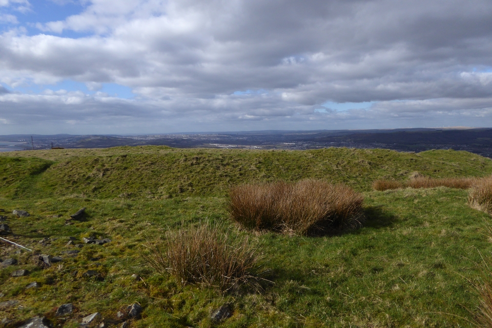
The northwestern rampart. Y Mynydd Du mountains on the right skyline.

The southwestern part of the rampart has been rather damaged over the centuries. Looking towards Mwmbwls and Gwyr across Bae Abertawe.

Looking over the southern rampart towards Twyn Disgwylfa, with the Hafren/Severn beyond.

The badly damaged round cairn inside the fort.

The eastern arc of the earthwork.

Southeastern rampart.
The southeastern rampart.
Visited 25 February 2023, after Twyn Disgwylfa round barrow. Carl came at this site the hard way; a much easier approach involving no fences is to take the forestry track from the minor road to the east, which leads to a gate into the field to the north of the hillfort, just above the cairn. From here it’s a gentle ascent over the grassy slopes to the fort. A rudimentary (i.e there’s no foot boards) stile then gives access to the earthwork.
It’s a pretty decent univallate ring, well preserved but not particularly big ramparts. The views are excellent, taking in Twyn Disgwylfa, Bae Abertawe across to Mwmbwls and the Gower, then northwards as far as the southern flanks of Y Mynydd Du.
There’s a small, dug out round barrow on the high point of the fort’s interior, which makes a good place to sit for a bit to get out of the fresh February breeze as the sun goes behind cloud.
From here it’s an even easier stroll back down the hill to the north, to visit the cairn and the neighbouring complex enclosure.
Visited 5.3.11
Directions: Take the very minor road north midway between Baglan and Cwmafan and eventually you come to a bridle way on the right; which presumably gives access to the transmitters on top of the hill? (Foel Fynyddau) Park here. Opposite you will see a metal field gate. Hop over the gate and head up the steep hill. You will have to cross two barbed wire fences and towards the top of the hill you will see a ruined stone field wall. Once over the wall, look for a rust metal field gate, ahead, to your right. Once you get to the gate the remains of Buarth-Y-Gaer Hillfort are easily seen in the next field. Unfortunately you have to climb over yet another barbed wire fence!
It is a steep, uphill 15 minute walk to get to the site from the car.
The enclosure is quite large and the single rampart is pretty well preserved, standing acout 0.5 metres high from the inside and between 1.5 and 2 metres high when standing in the ditch. The inside of the enclosure is quite ‘lumpy bumby’.
Due to the steepness of the climb and the number of fences to climb over I would suggest that this is a site for the dedicated and those fairly fit and agile!
Coflein describes the site:
Buarth-y-Gaer is an oval enclosure, c.140m E-W by 104m, set about the summit of Mynydd-y-Gaer, defined by a bank and ditch, with a W facing entrance. A cairn (Nprn307229) crowns the highest point of the interior.
Visited 5.3.11
Directions: Take the very minor road north midway between Baglan and Cwmafan and eventually you come to a bridle way on the right; which presumably gives access to the transmitters on top of the hill? (Foel Fynyddau) Park here. Opposite you will see a metal field gate. Hop over the gate and head up the steep hill. You will have to cross two barbed wire fences and towards the top of the hill you will see a ruined stone field wall. Once over the wall, look for a rust metal field gate, ahead, to your right. Once you get to the gate the remains of Buarth-Y-Gaer Hillfort are easily seen in the next field. Unfortunately you have to climb over yet another barbed wire fence!
It is a steep, uphill 15 minute walk to get to the site from the car.
The Cairn itself is easily seen within the earthworks. It is 20 paces x 15 paces in size and the centre has been dug into. There are large stones next to the ‘hollow’ which I assume are from the cairns centre?
There are decent views to be had to the north.
Due to the steepness of the climb and the number of fences to climb over I would suggest that this is a site for the dedicated and those fairly fit and agile!
Coflein describes the site:
A mutilated circular mound, 13.1m in diameter and 0.9m high, set upon the highest point of Mynydd-y-Gaer, within the ramparts of Buarth-y-Gaer (Nprn301301).


