Images

Image of Crug yr Afan (Cairn(s)) by thesweetcheat

Landscape context from Carn-yr-Hyrddod to the south. The cairn is on the top of the hill, centre, to the right of the forestry. Corn Du and Pen y Fan are the unmistakable mountains on the skyline over to the right.

Image credit: A. Brookes (5.3.2022)
Image of Crug yr Afan (Cairn(s)) by GLADMAN

Please keep the ‘trail-biker’ morons that do things such as this the hell away from me. It is a South Walian disease.

Image credit: Robert Gladstone
Image of Crug yr Afan (Cairn(s)) by GLADMAN

Substantial cairn, this – or perhaps that should be double cairn?

Image credit: Robert Gladstone
Image of Crug yr Afan (Cairn(s)) by GLADMAN

Mynydd Llangeinwyr (bearing Carn-yr-Hyrddod) can be seen approx centre skyline, the Glamorgan coastline far distance.

Image credit: Robert Gladstone
Image of Crug yr Afan (Cairn(s)) by GLADMAN

The antennae of The Werfa can be seen beyond.

Image credit: Robert Gladstone
Image of Crug yr Afan (Cairn(s)) by GLADMAN

The cairn’s a beauty.... the environs are a shambles, particularly during winter.

Image credit: Robert Gladstone
Image of Crug yr Afan (Cairn(s)) by thesweetcheat

Crug yr Afan seen prominently on its hilltop from the slopes of Werfa, to the SW.

Image credit: A. Brookes (8.6.2013)
Image of Crug yr Afan (Cairn(s)) by thesweetcheat

Despite some poor treatment, this remains an excellent monument. The “upper” and “lower” cairns can be easily distinguished from the south.

Image credit: A. Brookes (8.6.2013)
Image of Crug yr Afan (Cairn(s)) by thesweetcheat

Looking due south across the shattered “upper” cairn. The hill directly ahead is home to Carn yr Hyrddod, while the Ogmore Valley falls away to the left of centre.

Image credit: A. Brookes (8.6.2013)
Image of Crug yr Afan (Cairn(s)) by thesweetcheat

Looking SSE. The hill on the far left is Mynydd Ton, boasting yet more Bronze Age cairns.

Image credit: A. Brookes (8.6.2013)
Image of Crug yr Afan (Cairn(s)) by thesweetcheat

Small upright at the base of the “upper” cairn, possibly part of a kerb.

Image credit: A. Brookes (8.6.2013)
Image of Crug yr Afan (Cairn(s)) by thesweetcheat

Looking over the wrecked top of the cairn, showing the concrete block reported by Carl, which I think might be the remains of a trig pillar, fallen into the central scoop. The big hill on the far skyline is the near-2,000ft Craig y Llyn, topped with several of its own cairns.

Image credit: A. Brookes (8.6.2013)
Image of Crug yr Afan (Cairn(s)) by thesweetcheat

Arriving at the cairn from the north, thankful that the mud surrounding the monument has been baked hard.

Image credit: A. Brookes (8.6.2013)
Image of Crug yr Afan (Cairn(s)) by postman

you can just make out the shallow ditch on the right.

Image credit: Chris Bickerton

Articles

Crug yr Afan

Visited 29.6.10.
Despite the weather being in the mid 70’s with plenty of sunshine on the coast (I was heading for the beach via a small ‘detour’) it was misty with drizzle up in the mountains!!
Travelling west along the A4107 from the A4061 you come to a road sign which states ‘Welcome to Bridgend District’. Park near the sign on the grass verge and walk up the tractor tyre tracks heading up the hill parallel to the trees. After about 5 minutes the cair comes into view. Luckily I had my wellies in the car otherwise I would have got soaked. The cairn was a lot bigger than I expected and had been dug into. An old car tyre and concrete lump had been dumped in the cairn’s hollow. Despite this, it was very atmospheric – probably due to the weather?
The cairn is NOT visible from the road.

Crug yr Afan

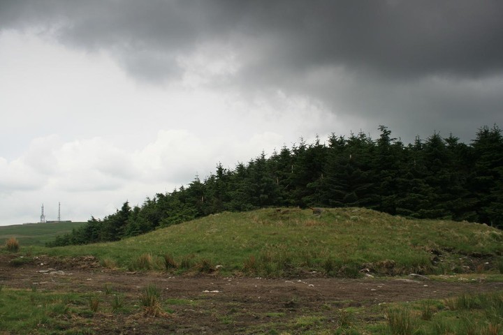
It was more or less on our route from Neath to Merthyr Tydfil and only a five to ten minute walk from the road, plus the coflein description was very interesting....

A complex monument consisting of a central clayey mound, 20.5m in diameter and 0.9m with, having a level summit, 13.5m in diameter, upon which rests a cairn, c.10m in diameter and 0.9m high, said to have been enclosed by upright stones, this is centrally disturbed with a small recent cairn set upon it. The whole is encircled by a ditch, c.28.4m in diameter.
Excavation, in 1902, revealed a cist cut into the subsoil, containing, burnt bone, a bronze model dagger and possible curated bone.....

There are no stones encircling the upper cairn but the two cairns, upper and lower, are easy to distinguish, and the ditch is only evident on the western side as the track and farming have destroyed or filled in the rest of it.
An untidy place, right next to a plantation, with untidy sheep willing us to leave, despite the long views to the south and east I didnt stay very long.

Sites within 20km of Crug yr Afan