
From below to the southeast, towards the end of a lovely walk from Hayfield to Castleton.
Image credit: A. Brookes (8.9.2021)
From below to the southeast, towards the end of a lovely walk from Hayfield to Castleton.

The excellent high level view of the ramparts from the eastern end of the Rushup Edge/Lord’s Seat ridge.

Seen from Lord’s Seat round barrow.

Retrospective view from Back Tor towards Mam Tor, with Lord’s Seat behind.

The western rampart, looking towards Lord’s Seat and the head of the Vale of Edale.

Eastern ramparts.


Long views westwards.

The southern rampart with Castleton and the Hope Valley beyond.

The view down to the Vale of Edale over the western ramparts.

The banks flanking the southwestern entrance. Lord’s Seat far right.

The steep approach to the southwestern entrance from the pass between Lord’s Seat and Mam Tor.

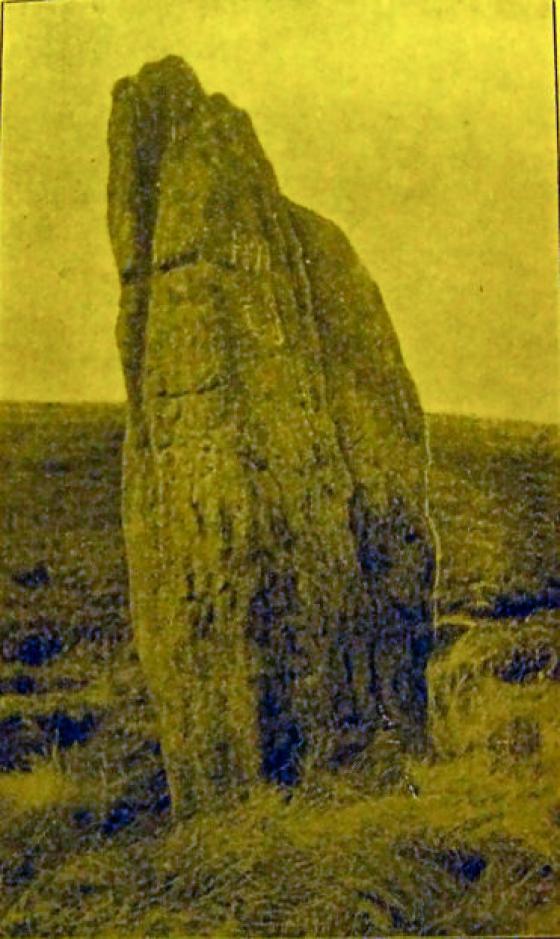
From
archive.org/stream/journalofroyalso3451roya#page/4/mode/2up
The Journal of the Royal Society of Antiquaries of Ireland, v14 5th series, 1904.

Mam Tor, with the edge of the Kinder plateau rising beyond, seen from Sir William Hill near Eyam.

Behold the summit and trig point of the Shivering Mountain!

The delightful stone steps and earthworks near the main entrance.

Looking down over the ramparts towards Castleton.

Looking back towards Lord’s Seat barrow (that tiny pimple on the top of the hill).

Panorama looking from North to East from the main entrance.

From ‘The jottings of some geological, archaeological, botanical, ornithological and zoological rambles around Macclesfield’ by J D Sainter, 1878.

The view from the Lord’s Seat path, showing linear and skyline ramparts

Mam Tor seen from Gautries

No wonder the road below is blocked.... and why Mam Tor is apparently known as the known as the ‘Shivering Mountain’. [scan of archive print]

Looking along the Noe Valley towards Mam Tor and Lord’s Seat.

Mam Tor (centre) watches over Edale and the Noe Valley. Lord’s Seat rises far right.

Mam Tor, from a snowy Castleton.

The rickety tree.

Taken from the information board in the car park, quite nice isn’t it.


Mam Tor (left of centre) standing proud in the distance framed by Gautries Hill and Eldon Hill. Am stood on a hill over looking the Bullring (Bibbington Hill?)... In the other direction Black Edge towers over Buxton and Lismore Fields. A prehistoric landscape and my jog to work...

09/11. From Peveril Castle.

Way up behind me is Lords seat barrow, infront Mam Tor hillfort/sacred hill


Plan of the earthworks of Mam Tor taken from William Bray’s ‘Sketch of a Tour into Derbyshire and Yorkshire’ 1783. Even then the hillside was slipping away (area marked ‘I’ on lower left).

Just a small part of the total number of paragliders out on Mam Tor today. This was taken from Odin’s Mine, where you could hear them shouting abuse at each other for coming too close.


the clouds rolled in

the peace up here this morning was total


Mam Tor defensive ridges, approaching from the North East. Again the cloud at once detracts but sharply defines the image – imho, of course :-)

Mam Tor defenses, approaching from the North East. I realise that the cloud cover detracts from the clarity of the image but I believe that it is suggestive of the drama of the place.

Approximately 1500 feet above Mam shows a clear layout of the fortifications.

The southwest entrance through the defenses.

View looking west from the base of the hill with the Hope valley directly behind.

View of Mam Tor looking north – it almost resembles a headless Sphinx!

View down the Hope Valley showing the hills on the northern edge.

I love Spaceship Mark’s comment about the road protesting hill, this is what happened to this particular puny attempt to skirt Mam Tor.

The view to the summit standing on the left side of the SW gate (SE if you read the signpost, but not according to a compass). The hillfort ramparts on the Edale side are visable to the left of the picture, rising to the summit trig point (fully paved – right on top of a burial mound), then imeadiately to the right of that is the remaining Bronze Age burial mound. The sunken path in the foreground leads through the gate itself, with the modern path to the far right of the picture.


Mam Tor, April 2003.

03/01/03ce.

05/02 Looking up from Mam Nick car park

05/02 Mam Tors defences

05/02 The defences at Mam Tor
On 6th June there will be a very rare astronomical event: a transit of the planet Venus across the face of the Sun. The last transit of Venus occurred on June 8th in 2004, and the next one visible from the UK will occur on 8th December 2125 (although there is another transit in 2117 which won’t be visible from the UK). The 2012 transit of Venus will be in progress by the time the Sun rises in the UK at 4:50am, and will be over by 5:55am. This means that only the very final stages of the transit will be visible from the UK, weather permitting.
The National Trust has given permission for representatives of the Peak District National Park Authority’s Dark Skies project to observe the 2012 transit of Venus from the summit of Mam Tor. Several astronomers will be on hand from 4:30am with telescopes and special glasses to allow members of the public, weather permitting, to view the transit of Venus.
peakdistrictnt.blogspot.co.uk/2012/05/mam-tor-and-transit-of-venus.html
Visited 26.5.13
On a bank holiday weekend in such beautiful weather the official car park was full but luckily we managed to squeeze in next to other cars in the bus stop at the start of the footpath leading to the summit of Mam Tor.
The children were asleep so Karen stayed in the car while I headed up the handy stone steps. There were numerous people about heading both up and down the hill.
Towards the top the path cuts across the easily identifiable ditch/rampart which still stands to a height of about 1.5m.
At this point the stone path had ‘open squares’ in it and stone rubble could be seen in the squares. I assume this was to show the make up of the rampart?
I can’t think why else the path would have been designed this way?
However, Mam Tor isn’t about the Hillfort, its all about the vista.
Stunning would be an understatement.
The only blot on the landscape was a large ugly factory of some sort.
As James Cagney once famously stated in one of his films ‘look Ma I’m top of the world!’
This is a place you could spend a long time.
Certainly a lot longer than I had with the others waiting in the car for me.
Visit, Visit, Visit.
Having cycled from Edale to Hollins Cross and on to Mam Tor I was deeply appreciative of reaching Mam Tor; on a squally day I was aware of just what a sanctuary the settlement must have been.
The great shame is that the path from Hollins Cross to Mam’s Tor, whilst making the going easier, takes away a certain something from the place as part of the landscape. Mam Tor is definitely a place with a distinct power to it as a dominant point within the landscape. This, coupled with the unpredictability of conditions underlines what a centre of natural forces it is. The path, then, seems little more than a vain attempt to manage the unmanageable.
Having said that I think that it is a better approach than from the picnic area to the SW side. The climb from the valley floor (whether the Edale or Castleton side) up to Hollins Cross and then on to Mam Tor gives you more time to appreciate the location and the nature of the ground beneath you. Having ‘earned’ her I always find Mam Tor more welcoming.
Wow, seriously impressive. As you approach from the west it’s hard to judge the scale of the hill until you start to pass by on the south side of it. If you then take the turn north and follow the old road as far as it goes you get a whole other perspective on Mam Tor as you stand facing the crumbling eastern face with its alternate bands of sandstone and shale and distant birds of prey hovering over the summit. Turning round 180 degrees gives and entirely different view down the Hope Valley, on the right hand side lies Castleton and the intrusive tower of the cement works beyond but to the left is an interesting line of hills, one of which, Win Hill stands like a tiny pyramid on the horizon 4 miles away. Coming from Lincolnshire I’m not used to landscapes like these and I wonder if early settlers had the same reaction when travelling west up the valley, Mam Tor stands like a giant full stop that marks the end of the journey. Stood at the foot of it looking east I was strangely reminded of standing at the west end of the Stonehenge Cursus near to the destroyed long barrow looking in the same direction down the faint parallel banks into the distance – this place is like the Cursus landscape written large in nature.
I’ve never been that convinced by Sacred Hill theories in the past but this one certainly does it for me, I didn’t have time to attempt the climb up to the top or see the hillfort or barrows but definitely a place to revisit soon.
Edit:
A couple of weeks later I went back and climbed Mam Tor – well worth it but a bit exhausting – the views are spectactular.
Cling to the Mother lest the winds blow you cartwheeling over Castleton, tossed like the hang-gliders below their flimsy gashes of colour against a perfect blue sky.
Cling to the Mother, like you clung to your own mother’s breast, and press your ear to the grass to hear the mountain’s heartbeat.
Cling to the Mother, to hold on to her before she slips away down the slope, her body crushed up for the smoking cement works you see below.
Woah... she does smack you in the head. Possibly the only road protesting hill in Britain. This momma has had a massive landslide creeping slowly down its side for centuries if not millenia, giving it the nickname the shivering mountain. The result of this is the road they tried to build accross it contantly kept collapsing for about 70 years until they eventually gave up a few years back.. Right On.
Anyway, capped by the remains of an Iron Age fort this natural proto temple struck me the first moment I saw it, knowing nothing about its ancient associations, I knew something was going on.
Check it out, especially in the driving wind and rain.
Hence I went to Mamme Torr, which is an high Mountain broken on one Side, of which the Tradition is, that the Earth continually falls down, yet is not the Hill any thing diminished, nor the Heaps of Earth below at all encreased.
I got as near as I could to the broken Side, but could not hear or see any such running down of the Earth; when there is Rain, the Water running down washeth away with it much of the Hill.
I was informed, that on the Top of this Mountain is an antient Roman Camp, encompassed with a double Trench, whereabout are sometimes found Store of antient Roman Medals.
p177 in ‘Select Remains of the Learned John Ray, with his Life’ by William Derham. Published 1760.
Online at Google Books.
John Ray’s journey to Mam Tor was made in 1658.
A later visitor didn’t believe the hype:
Mam-tor is a huge Precipice facing the East, or South-East; which is said to be perpetually shivering and throwing down great Stones on a smaller Mountain below it; and that nevertheless, neither the one increases, nor the other decreases in Bigness.
This Mountain is composed chiefly of a Sort of Slate-Stone (called in that Country Black Shale and great Stone. The Nature of the Black Shale is known to be, that notwithstanding it is very hard before it is exposed to the Air; yet it is afterwards very easily crumbled to Dust. Thus on any Storm, or melting of Snow, this Shale is considerably wasted; and as the great Stones are gradually disengaged, they must necessarily fall down.
That it is only at these Times that the Mountain wastes, is affirmed by the most intelligent of the neighbouring Inhabitants: And that this Decay is not perpetual, I can affirm myself; having not only taken a close Survey of it, but also climbed up the very Precipice, without feeling any other shivering in the Mountain, than what the treading of my own Feet in the loose crumbled Earth occasioned. That the Mountain does not decrease in the mean Time, is a Tale too frivolous to need any Consideration.
An Account of some Observations relating to Natural History, made in a Journey to the Peak in Derbyshire by Mr. J. Martyn, F.R.S. From the Proceedings of the Royal Society of London, 1753.
The first evidence of activity here consists of Neolithic flints and a polished axe head, next comes the pair of round barrows. The hillfort itself (known as a slight univallate hillfort) dates from the later Bronze Age and seems to have been used and modified into the Iron Age with the original wood and earth rampart being replaced by a stronger stone affair. The defences which enclose an area of about 6 hectares are built (from the inside outwards) with a rampart about 3 metres high and 5 metres wide followed by a flat berm and a U shaped ditch which would have been a couple of metres deep and about the same wide. This has now silted up and the berm and ditch are at the same level. Beyond these was a small outer bank that was probably no more than a metre high. There were entrances to the north and the southwest and the central area was covered with over 70 huts whose bases had been cut into the hillside giving a flat platform before the walls were erected. Excavations have revealed hearths and storage pits as well as large amounts of pottery sherds and whetstones.
Old aerial photo of Mam Tor looking west along Rushup Edge. Windy Knoll in upper left of picture.


