|
|

|
|
Helsbury CastleHillfort
|
||||||||||||||||||||||||
|
|
|
Images (click to view fullsize) |
|
|
Fieldnotes |
|
|
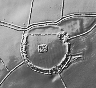
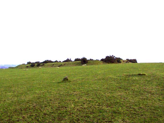
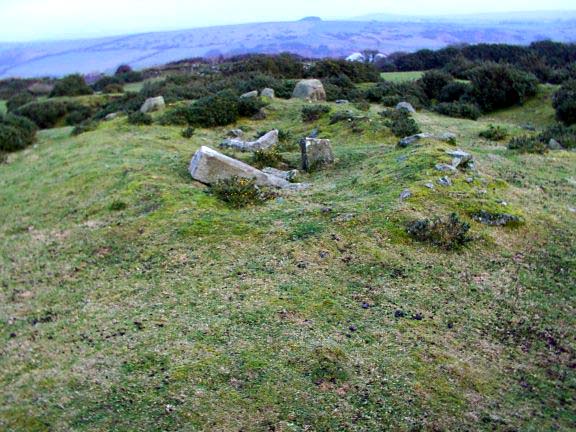
Below are the descriptions found in the Cornwall Historic Environment Record PRN No 17789 (Site Number) Helsbury Castle is marked on current OS maps (b4). It is visible in air photos (p2) and was plotted as part of the National Mapping Programme. It is described in an Royal Institution of Cornwall report of 1850 as a near circular camp of a single bank and ditch with outworks to the north-east. The diameter of the interior circle is about 460 ft (140m) and the length of the arched outwork 400 ft (122m) by 200 ft (61m) broad, this being the entrance to the camp. (B1). A field visit by the Ordnance Survey revealed that the main work is generally well preserved although part of the southern rampart and eastern entrance have been damaged by quarrying. The outerwork is ploughed down and its entrance is no longer discernable. To the north-east of the outerwork are numerous irregularities, possibly surface quarrying (h2) (17789.01). A sherd of decorated (probably) Iron Age pottery was handed in to Cornwall Archaeological Unit by Jennie Stopford which was found in a disturbance from a large badger barrow. In the centre of the hillfort is a large rectangular enclosure, the site of St Syths chapel (17790). During 1988 the ramparts of Helsbury Castle were cleared of dense vegetation by the British Trust for Conservation Volunteers (b8). The name Helsbury is first recorded in 1284 when the name was spelt 'Hellesbury' (b6). It is a combination of Cornish and English elements; hen-lys 'ancient court', 'ruins' and bury 'fortification (b7). 3-year management agreement to 9/1/98. PRN No 17790 (Site Number) The 'remains of St Syth's chapel' are marked on current OS editions (b5). A small rectangular enclosure in the centre of Helsbury Castle (prn 17789) is known as 'the chapel' (b2). This enclosure is visible on air photos (p1) and was plotted as part of the NMP. According to Henderson, the name St Syth's seems to rest only on the authority of Lysons (b1). And it was more probably dedicated to St Michael (b4). Fletcher, however, disputes this but says that no authority can be found to resolve the dedication. As the parish name is derived from the parish church of St Michael it would seem to be unusaul to have a second St Michael in the vicinity. The Michaelstow Beacon would relate to the parish rather than the chapel (h2). Maclean says that 'on top of the hill are ruins of a small quadrangular enclosure measuring 85ft by 65ft within which are the remains of a small building. A few years ago, excavations were made within the building by Rev E.T. Gibbins but nothing distinctive of a chapel was discovered'. However Maclean goes on to say 'there on the site circular headed arch cut in a solid piece of granite of an octagonal form externally, having a span of 2ft 6 inches and a height of 10 inches. The edges being chamfered and also part of the head of another arch, of a wider span with mouldings of the third pointed period (b3). A field visit by the OS revealed that the remains of the chapel comprise 8.0m, by 6. 0m stone footings up to 0.8m high internally with large granite quoins. At 2 corners there are foundations of a possible tower at the w end. The two s egmental doorheads are as described by Maclean and also a 1.0m long carved granite stone which may have been a door jamb. There are no recorded rights of burial and the enclosure bank around the chapel is probably protective rather than indicative of the extent of a burial ground (h2). Recent visits by field monument wardens indicate that architectural fragments are still present |
Posted by stevebergman 11th January 2004ce Edited 11th January 2004ce |
|
After walking around Michealstow I decided to head up to the Beacon. I local farmer had told me that although it is on private land there was a stile over the wall that everyone uses. This was not the easiest thing to find but once over the walk to the hill fort was simple. The gorse covered banks surround the site of a medieval chapel and some stone work remains amongst the undergrowth incl part of an arch. Some of the forts original banks have suffered from sheep erosion and in places the area has been quarried for the local greenstone. It is still a wonderful place in which to sit and take in the views. |
29th September 2003ce |
|
In a stroke of genius I booked another week in Cornwall for the week the clocks change, and a week of stunning weather! It is early April and Bodmin Moor is tinder dry. Just before I arrived there had been several small fires in North Cornwall nd the day I left there was a large gorse fire at the other end of Cornwall (on the Lizard peninsula). I stopped off in Dartmoor on the way, the sun was blazing and Fernworthy forest was so peaceful. Although it’s usually only the circle that is talked about Fernworthy is one of these ‘complexs’ with a stone circle , two cairns and cairn circles, two stone rows, and possible others. I was so taken in that I began to think I was an archaeologist for a day and soon I will have to unleash diagrams onto this fantastic TMA site! The south side of the forest also has a stone row. And a brisk walk onto the moor brings you to the Greywethers, a restored and stunning double circle. I also tried to find the Heath Stone on the way out. Does visiting ancient sites get much better than today? On Sunday I went to the St Breock Downs area, checking out the St Breock Wind Farm Barrow, the colossal Men Gurta Menhir, and peering at the St. Breock Downs Menhir. I then moved south to the China Clay country (sounds like a theme park) to find the moved Menevagar / Roche Longstone and the huge Hensbarrow - this is the highest natural point in the area and the views back across the valley are stunning, with the St Breock Downs wind farm clearly visible. However, if you ignore the nice bit of the view you could just as easily think you are sitting on the moon as the clay works surround you. To round off a pretty lazy day I visited the two sites closest to where I was staying – Headon Barrow and Warbstow Bury, the later being quite stunning and the best-preserved hill slope fort in Cornwall. On Monday I pleasured myself (steady on!) with a trip to the St.Austell Brewery - http://www.staustellbrewery.co.uk - and onto Mevagissey for sarnies on the harbour. I had forgotten my maps so instead of heading off for some yomping on Bodmin Moor I had to pull Plan B out, which was a visit to The County Museum in Truro - http://www.royalcornwallmuseum.org.uk - I knew that the famed cup marked stone from the Tregiffian Burial Chamber was there, as was a copy of the Rillaton Cup, and other things. There is a huge amount to see and as they are a registered charity it is £4 well spent (and please fill out a Gift Aid form, so they can reclaim your tax!) Tuesday led me on a huge barrow hunt, including the massive Tich Barrow, one of the Starapark Barrows, the Advent Triple Barrow (a rarity), and the Crowdy Reservoir Barrow and then several wind swept hours in the Roughtor area, including the Showery Tor ring cairn and cheesewring, and the Showery Tor Embanked Avenue, the Showery Tor Downs Cairn, Roughtor Slopes Cairn and three possible standing stones in the area. In an action packed day I also went to the fascinating King Arthur’s Hall, , the nearby King Arthur's Downs Stone Circles, the Casehill Cairn, and explored around the area; expect a diagram soon! On the way home I had a quick stop at Helsbury Castle. Like it or loathe it I thought The Museum of Witchcraft - http://www.museumofwitchcraft.com - was worth a visit so the next day I went to see it in Boscastle’s picturesque harbour. I was glad to see the Museum asking people not to have fires, leave rubbish or ‘inappropriate offerings’ at ancient sites. Later I visited three great cliff castle’s close by – Willabury Cliff Castle (Boscastle) plus the fascinating ‘stitch’ system of agriculture on Forrabury Common, Willabury Cliff Castle (Tintagel), and Tintagel itself. I also saw the curious Rocky Valley Rock Carvings but I’m even less convinced now. I had a quick search for Ugworthy Barrows (actually over the border in Devon) and the rare Woolley Long Barrow. I really don’t seem to have got the hang of these ‘holidays’ have I? Not much resting going on, so I only went out on the moors late on Thursday, and spent some of Friday re-reading one of favourite books on the beach at Crackington Haven (‘Life and Times of Michael K’ by J.M.Coetzee if anyone is interested). So several hours on Thursday were spent on Fox Tor & East Moor and in the Leskernick area of Bodmin Moor. Two totally different environments in one way (the former gorsey and brown, the later green but scarred and pitted like the moon) separated by the A30 but both full of ancient sites, and continued finds. East Moor includes the Fox Tor Stone Row (apparently), the East Moor Stone Row, and possible Menhir / Stone setting, and the Nine Stones of Altarnun. The Leskernick area is still being explored and new things still being found. My few hours included Leskernick Stone Row, a cairn near the stone row, Leskernick Stone Circel (Northern), Leskernick Stone Circle (South), the Leskernick ‘Quoit’, the Cairns on the summit of The Beacon, and a possible Kerbed Cairn and Barrow Cemetery on The Beacon This post appears as part of the weblog entry Another Kernow Week
|
 Posted by pure joy
6th April 2003ce |
|
Helsbury Castle or Beacon is a fine circular earthwork. Looks like it could be Iron Age. It has a square ruin in the centre said to be the remains of a medieval chapel. The site is 684 feet above the sea and is sometimes called St. Syth’s beacon. The chapel must be pretty old as it was in already in ruins when William of Worcester visited it in1478. It reminds me very much of Knowlton Henge in Dorset which also has a religious building plonked in the middle. http://www.themodernantiquarian.com/browse.php?site_id=44#post-2117 Great views of Roughtor to the north-east. |
Posted by phil 6th January 2002ce |