|
|

|
notjamesbond’s TMA Blog |
|
From Rum to Rodel, our search for all things historic
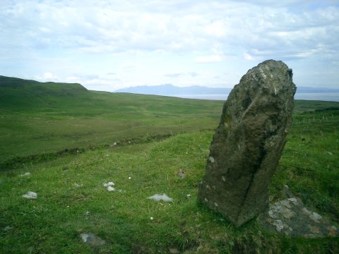
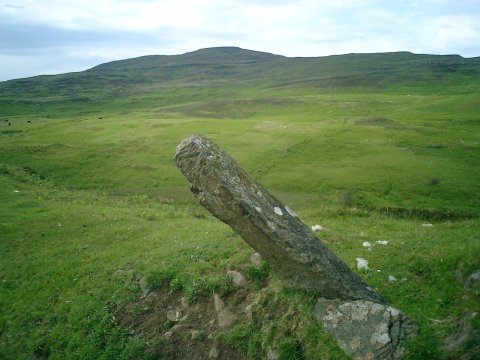
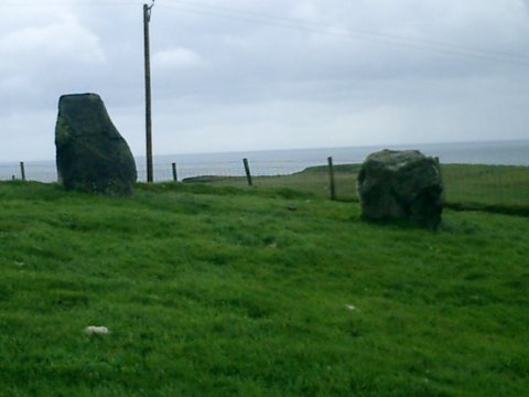
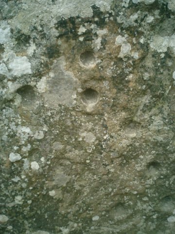
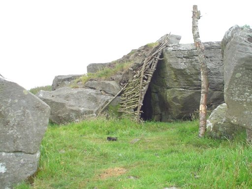
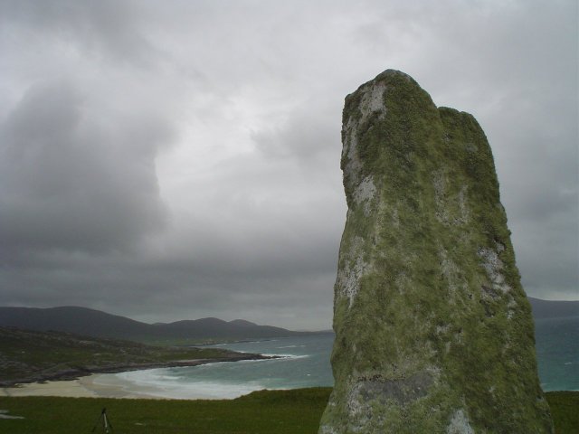
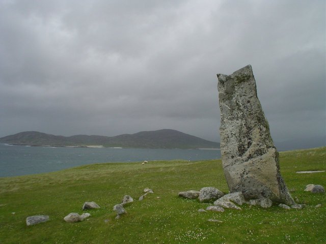
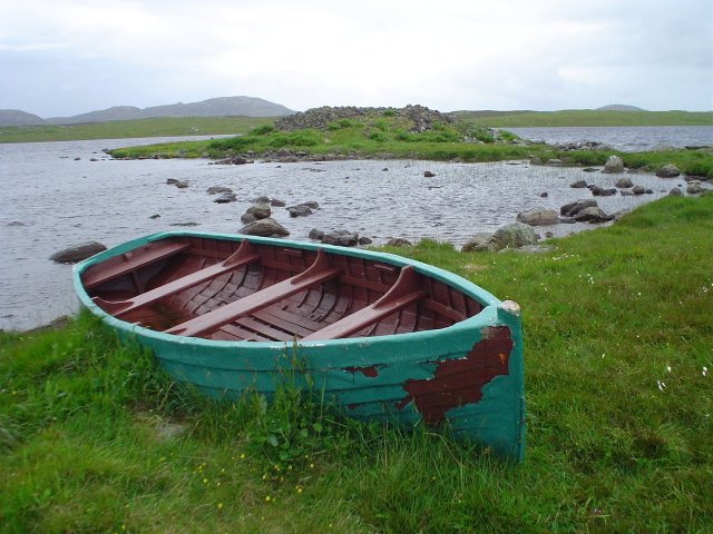
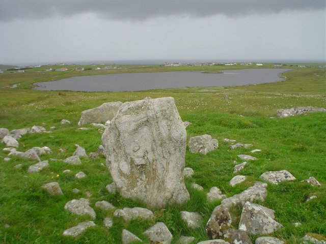
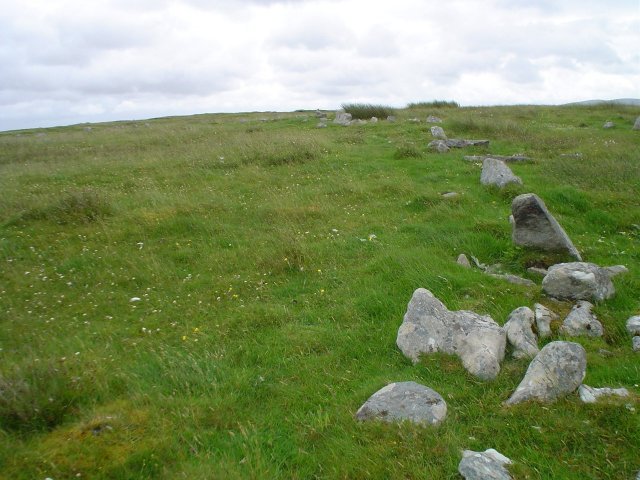
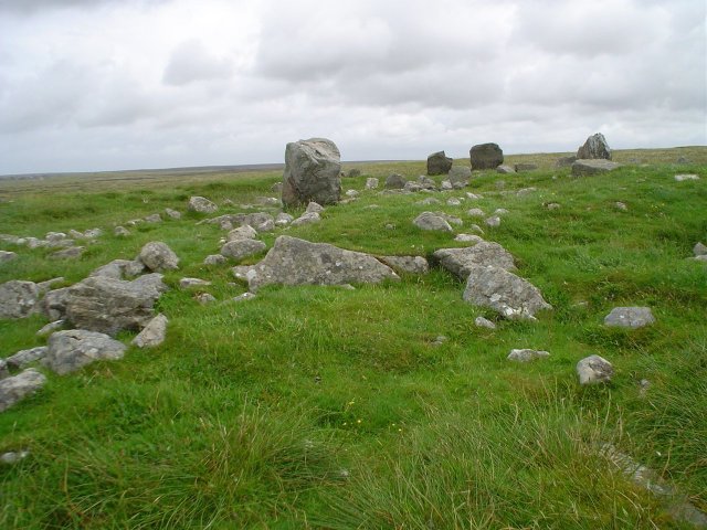
| The plan was to head around Scotland and the isles for nine days and eight nights to see whatever it was we could see. The supposed highlight of said trip would be a visit to the tiny inner hebredien islands of Rum and Eigg. In particular we would try to seek out the standing stones labelled on OS maps on both islands. The journeys pace was slow to begin with, a night in Alston, the highest market town in England, was enhanced by its being a Saturday and the liquor flowed accordingly. The following day a journey up north to Scotland! A stop off in the borders town of Moffat for Haggis with neeps and tatties. I have yet to find a place better than the Balmoral Hotel in this town at serving this particular Scottish delicacy. It really does set you up for the long drive up north. We needed it too, after getting lost in Glasgow we decided to take a peek at Dumbarton Rock only to get lost in Dumbarton as well oops! Eventually we ended up in Glencoe and were blessed in the fact that the set for the latest Harry Potter has been built up on the hillside. You can see Hagrids House, another construction that looks like it could be a passageway of somekind and, surprise surprise, a makeshift set of standing stones. After trying to sneak onto said set for a better look our plan was scuppered by one of the many security guards manning the site. Well, at least the view wasn’t too bad from the road. The cast and crew by the way had taken the weekend off from filming, lucky them. Ah well! Onto the famous Signal Rock! The Signal rock has a rather macabre history as it was from here that the signal was sent in 1692 to start the massacre of Glencoe when members of the Clan Campbell slaughtered their hosts the MacDonalds whilst they slept in their beds. The rock is to be found by following a path away from Glencoe town into a wooded glade. About a mile from the Harry Potter set is the rock and atop the rock midgies reign supreme. It must be said any trip to this part of Scotland must come complete with lots of insect repellent. As we rushed back along the path to the car, my eye caught a funny shaped rock just off the side of the path partly obscured by undergrowth and merging in quite well with the other rocks in the area. It looked like a standing stone although there is nothing to indicate this on the OS map. A puzzle indeed but it didn’t look like it should have been there so I took a couple of pics and have submitted accordingly, take a look and see what you think. From Glencoe we moved on to Glen Nevis in a hostel at the foot of the mountain. We were greeted with woeful indifference and placed in a room with 22 other men to sleep for the night. Needless to say our time there was not pleasant and we could not wait to head along the Road to the Isles in the morning. This road is really one of the most picturesque roads in Scotland. From Fort William to Mallaig we passed the Glenfinnan monument which commerates the first time Bonnie Prince Charlies standard was raised on Scottish soil. More recently Glenfinnan viaduct had a starring role in the movie ‘Harry Potter and the Chamber of Secrets’ (you know the bit where the car flys over the bridge – don’t tell me you’ve not seen it :-o). In Mallaig we parked up the car and boarded the ferry to Rum. The plan was that we would have about two and a half hours on the island whilst the ferry sailed on to the neighbouring small isle of Canna. It would return and take us back to Eigg where we would stay the night. Rum is a nature reserve and the only people who live there are wardens who look after the island. Visitors are welcome in the form of daytrippers like ourselves and hostellers who are able to stay for a few days at the hostel. Time was not our friend unfortunately and we had to make do with a few hours. One of the previous owners of the island had built an impressive castle on the harbour at Kinloch. It is by far the most impressive of only a few buildings on the island. We took a peek and took the obligatory photos rejoicing in the baking heat that was beating down upon us. Afterwards we made our way along a path which took us along the coast and through a number of ghost settlements long abandoned by there previous occupants and forgotten by all except those who wander here. The Ordance Survey map indicated that the path ended after about a mile and a half along the coast. We reckoned that it would be another half a mile along the coast before we came to the standing stone which is clearly marked on the map but which no one else seemed to know anything about. It was a brave attempt which ended up ultimately fruitless, the terrain did not aid our journey and eventually the sound of the ticking clock just grew too loud. We needed to head back to catch the ferry to Eigg The sight we were greeted with as we ran red faced and out of breath to the new makeshift docks was not an encouraging one. That of a boat pulling away from the harbour and heading towards the rather larger Calmac ferry moored someway out laden with its cargo of daytripping passengers. Our despair was compounded by the knowledge that the next ferry to Eigg was in two days time and the Calmac operators had no obligation to turn the shuttle ferry back to pick us up. We’d missed the boat and all we could do was hope that the captain of the ship would show a bit of mercy to the poor young fools standing heads bowed on the shore. He did luckily for us, the shuttle boat picked us up and we were greeted with laughter and sly giggles by the girls behind the coffee shop counter. A cup of tea was sheepishly purchased and we relived our shame over a fine brew. Eigg is the second largest of the small isles after Rum. The other small isles are Canna and Muck and none can be easily accessed by car ferry. On Eigg an island made famous by the fact the locals were able to buy back the land from there stay away landlord, this is a problem. The island is the most populous of all the islands with a princely population of 78. There is a four mile road stretching from the port at Galmisdale to the small village of Cleadale on the north of the island. A car ferry would encourage more visitors to the island and encourage more people to come and live there. It would also enable someone to get all the disused rotten junk away from the island. Eigg is a stunningly beautiful place but it really is threatening to become disfigured by the sheer amount of fly tipping which seems to be going on. The standing stone of Eigg is not to be confused with the monolith at the harbour commemorating the islands takeover by residents. This menhir stands proud looking over the new ferry terminal construction but the stone marked on the OS maps was about two miles further inland and pretty much in the centre of the island. Walking there was pleasant and not strenuous, this stone was certainly easier to find than the one supposedly on the island of Rum, it was just off the side of the road, its always nice when they are so conveniently sited don’t you think? After posing for the obligatory photographs we set off back along the road in the hope that it wouldn’t be too long before we reached the farm in which we were staying. After about half a mile we came upon another stone which didn’t look like it should have been there at all. This was smaller than the previous stone and was tilted at an angle. I again took some photos and named it the Eigg lesser stone ;-) Eiggs geology is absolutely fascinating and its famous ‘scurr’ can be seen from all points of the island. It is the natural feature for which Eigg is most famous and dominates the landscape around. Basically it’s the largest columnar pitchstone of lava anywhere in Britain. It was formed at the same time as the island of Rum when the lava rushed up through the valley previously there to form an impressive summit. Eigg by the way is from the Scottish Gaelic Eag meaning ‘notch’, ‘nick’ or ‘gap’. A testimony to the shape of the island as seen from the sea. We decided to take a short cut along a path which in theory cut our travelling distance by about half a mile. We followed the path through woodland and then through bog. My companion managed to fall into a thorn bush scarring his legs. Eventually we came to the end or so it seemed. Before us the northern tip of the island of Eigg spanned out before us. A breathtakingly beautiful sight it really is a shame that not many people have heard of the island let alone visited. As we surveyed the scene the realisation soon dawned that we were in fact standing atop of a sheer cliff and the farm in which we were staying was in the valley bottom. The view was not enough to hold back our despair as we realised that somehow we had to find a way down. But find a way we did. After fording a stream and a few more bogs we came upon a path leading to the farm. We were welcomed at the door and ushered into the dining room for home made tomato soup following by sheperds pie – bliss! I could spend all day talking about Eigg but I will try to avoid going on too much. That evening we set off along the coast to a beach known by locals as the ‘squeaking sands’ so called because the sand is made of fine quartz crystals which ‘squeak’ underfoot. The geology on the beach was very interesting and we took a whole load of photos in the twilight. The following day we wandered back along the road to the port. Stopping off at a derelict church which boasted a celtic cross, sadly being left to erode at the mercy of the elements. The church had a bloody history in itself. In 617AD St. Donan and his band of 52 followers were brutally murdered by pirates after establishing a monastery on the site. Leaving Eigg, the trip to the mainland was uneventful, we stepped once more onto the shore at Mallaig and cast a forlorn look back from where we had come. In the time we spent waiting for the next boat to Skye (for that was our destination) we dined on Haggis once more. Although this was a disappointment after the delights of the Balmoral Hotel. We arrived in Armadale on Skye after the short ferry journey ‘Over the Sea’. We were blessed as a petrol station with a staggeringly high rate of diesel was one of the first places we saw. We needed the gas so we filled up and headed onward along the beautiful south coast road. The weather was lovely and the sun beat down on the Cuilins ahead. We were lucky that day to get such perfect weather on an island famed for its mist. Glen Brittle Youth Hostel was the destination at the foot of the Black Cuilin. Not far away was a chambered cairn by the name of ‘Rubh an Dunain’ which I think translated would mean fort on the headland. We’d have loved to have gone to visit it but from the end of the road it was another 3.7miles away along the coast. We just didn’t have time and so contented ourselves with Doritos and Salsa dip whilst we reviewed the footage filmed with our video camera that day. We awoke in the morning to the sound of rain battering the windows and the wind howling loud outside. We had wanted to see the Old man of Storr on the other side of the island but in this weather chance would be a fine thing. We opted therefore to visit Dunvegan Castle the ancestral home of the Clan MacLeod and the oldest inhabited castle in Scotland. Dunvegan also played host to the famed ‘fairy flag’ which, when unfurled, legend has it, has the power to turn the tide of battle. It’s just a tattered bit of cloth now but according to the leaflet in the castle it actually dates from around 400AD. On the way to Dunvegan we noticed a broch by the name of Dun Beag high up on the hill by the side of the road. The weather was against us but we managed to clamber up to the top where part of the stairway can still be seen as well as the overall shape of the building and side cells. From the top we enjoyed views looking out over Skye and Loch Caroy although we paid for them with fierce gales battering our reddened faces. The castle at Dunvegan offered us shelter and warmth although the £6 entrance charge soon sent a chill back down our spines. The castle not only boasted the fairy flag but also a waistcoat worn by Bonnie Prince Charlie and the lock of his hair given by him to Flora Macdonald as he fled from Culloden pursued by government forces. The dungeons were particularly gruesome and there was an interesting display about St. Kilda in one of the corridors. Alas a group of sight seeing Americans were hogging the gift shop so buying momentoes would have proved tiring. As time pressed on we headed for Uig, the port from which we were to sail to Tarbet on Harris. Considering the weather we did wonder whether or not the boat would be cancelled, but to be honest, we needn’t have worried. Calmac are an efficient organisation and they do not cancel boats at a “mere gust of wind”. On the way to the ferry we passed the standing stones at Eyre. Looking out over the loch they shared a field with a rather large group of inquizitive cows who seemed to take pleasure in following us around. We walked briskly up to the stones, lingered for a minute until the cows had lost interest and then walked briskly back. Following a fine meal at the ‘Pub on the Pier’ in Uig (we were fortunate in being able to sit next to a window overlooking the ever swelling sea) we made our way onto the boat for the two hour journey. The stodgy haggis had taken its toll and we both soundly slept thus not really appreciating the roughness of the Little Minch. Harris is a peculiar place, full of extremes. On the west coast are beaches which surely match the finest on earth, yet on the east and in the north, the landscape is barren and rocky. Stanley Kubrick in filming his masterpiece 2001 A Space Odyssey used the rocky terrain of Harris as a double for Mars. Testament indeed to the out worldly nature of the place. Across one of the beaches on the west side there is a signpost directing the traveller to a place known as ‘The Macleod Stone’. An impressive monolith perched on a hilltop looking out over to Taransay, the island made famous by the BBC’s survivor programme. To get there is no chore although the beach does seem to stretch forever and apart from sinking in the soft sand and leaping over the odd channel it’s a pleasant trip. However, this is Harris, a place renowned for its unpredictable weather. As we reached the stone, the wind started to howl and the rain buffeted down. We took our pics and struggled back to the roadside fighting the elements. Our destination, the restored and impressive looking St.Clements church on the very south of the Island in a village known as Rodel. Here we have another example of the Macleods leaving there mark. The church was built by them in the 16th century and is the final resting place of several of the Clan Macleod. The first time I’d visited this place was with my father seven years ago. Then I remember being impressed by all the same things as now. Except one place always stuck in my mind….the toilet. I know, not the sort of place that you usually remember and if you did it would be for all the wrong reasons. The smell, lack of toilet paper, graffiti etc. But this place, the Rodel toilet, was different. In 1996 there was a guestbook, now in toilet terms, that’s a sign of class. There were pictures on the wall and flowers inside, the place was scented with pot pourri, my goodness I could have stayed all day. In 2003 the place was still there in a semi-permanent portakabin outside the church. But my memories were all that remained of how the place once was. The pictures, the flowers and the guestbook had all gone. Although thankfully there was no graffiti, the place lacked the magic that I had once known all those years ago. Dejected but still happy to be on this lovely island, we set off along the barren and rocky east coast road towards Lewis. Now we all know that Lewis is one of the places to go if your interesting in antiquity and stone circles etc. Lewis plays host to Callanish a wonderful place which evokes mystery and wonder. But Lewis also offers so much more, stone circles, brochs, duns, menhirs, Vikings, blackhouses, scenery and water lots and lots of water. We wandered first to the impossible to pronounce Cnoc Fillibhear Bheag. The ground was marshy and the rain had started to pour down. Not that we were too bothered; to wander round all the Callanish circles had been another main point to the trip. A path links Cnoc to another circle a couple of hundred metres away known as Cnoc Ceann a’Gharraidh. A place with an equally long and difficult name and which boasts quite a cool triangular stone which we took the opportunity to shelter behind whilst the wind threatened to blow us into the bog. Callanish could be seen in the distance its stones like needles sticking up from the ground. I had been there once before again in 1996, but my friend had not. I had been impressed with its size and complexity then and now my feelings remained. What went on here really? Why was it built? All these questions penetrate your head as you weave your way through the stones. It was 8pm by the time we got to Callanish, a good time it seems as all the crowds had long since left. A couple who were also wandering around told us that they had been there earlier that afternoon and the place was just heaving with a combination of tourists and druids. Druids! Of course! The summer solstice was only two days away. Not that we’d be here for that unfortunately, we had a tight schedule to work to. Maybe next year… Our destination for the evening was to be the renovated crofters village of Garenin. Itself a place that should most certinaly be visited if on Lewis. It boasts a popular youth hostel which attracts a lot of young people eager to sample the simple delights of staying in a original blackhouse. There is always a friendly atmosphere and banter to be had. People from all over the world converge on this one place. We were the only English people there, the rest where travelling from Canada, Austria, Holland, USA and there was a Glaswegian too. Alas despite jovial atmosphere and the warmth of the coal fire, we were still to be denied. There was no room at the inn, all the beds had been taken. The floor of the kitchen was to be our bed that night. A night which soon threatened to turn into morning and it would have done had we not kicked our fellow hostellers out of our makeshift ‘bedroom’ at 2 in the morning. A debate fuelled by alcohol had been raging about all things from the latest movie releases to the suitability of the Scottish Parliament. After our day, we just wanted to get to sleep. Fitfully we did so only to be woken up by an apologetic couple trying to get to there milk in the fridge. The days plan was to wander up the historically packed Western coast of Lewis and see as much as it was humanely possible to see, Garenin was the ideal place from which to start. Dun Carloway is the most impressive broch in the Western isles and next to Mousa Broch in Shetland probably the most impressive in Britain. It was here that we stopped off first. I love brochs there great, you can fight your way through wind and rain to get to them and when you finally get inside you can fell sheltered and safe. Most brochs originate from the Iron Age and were fortified farmsteads. Brochs could house people and animals inside and keep stores for weeks maybe even months. Dun Carloway dates from the 1st century BC and is situated on top of a hillock overlooking its manor. A wonderful place. There are all sorts on the Western coast of Lewis. Most are ‘blink and you’ll miss it places’ such as the unsignposted Loch an Duna Broch, the remains of which lie on a small island linked to the mainland of the loch by a ever more waterlogged causeway. Theres another one on a loch just a few miles up the road. The loch at shader, itself overlooked by the remains of a chambered cairn known as Steinicleit. Opposite Steinicleit (which could date from 3000BC) past the loch is the huge monolith of Clach an Truseil. An absolutely huge stone which now, I was reasonably surprised to note had a picnic bench not too far away from it. In addition to the old stuff, the coastal road also boasts a renovated Norse mill, an original working Blackhouse and museam at Arnol a huge whalebone arch by someones house in Bragar and another interesting little museam at Habost. Not many pubs or places to eat though we did notice that! We finally met the druids in a little church on the very north of the island. At a place called Teampall Mholuaidh or to give it’s easier to remember name, St. Moulags. St. Moulags is just north of Port Nis, it has an impressive Celtic cross outside and it can only be reached after following a nice straight path for about 200 yards. The church is thought to have dated from the 14th century although it is thought that the Norse also had a settlement or maybe even a castle there before that. One suspects that this site has actually been used for various purposes well before the norse arrived. Tales we had had learnt of sacrifices of ale to the sea god Shony made me think of the film ‘The Wicker Man’ and wonder how important this place actually was to people in antiquity. Surprise surprise it was raining again although as we wandered down the path it began to get heavy. Our walk turned into a jog and the jog into a full pelt run for cover. How we hoped that the door to the church was open and how grateful we were when we found out it was. The two of us burst in relieved and then slightly embarrassed as we realised that the building was actually full of people. We sat down quietly at the back and composed ourselves for a few minutes. All the folk in the church had there eyes closed, deep in thought. It soon became apparent that a ceremony was going on, one that I had certinaly never seen from my days as an alter boy at the local church. It a nutshell, the ceremony consisted of everyone slowly but surely moving from one position to another so that eventually four people were seated around the alter and the rest were standing in an line down the aisle. Three of these were just behind the font at the back of the church. Most peculiar to one that has never seen that sort of thing before. The ceremony ended with everyone hugging and bonding, they all had big smiles on there faces and all seemed to be at total peace. I can think of many religions which could take a leaf out of the druids book. I think the best part was actually seeing a druid, I’d never seen one before but if I were to hazard a guess I’d say that they’d come complete with white robe and stick. But not a robe in sight, instead the people were dressed just like my companion and I. Wearing macs, waterproofs and absolutely sodden wet. After leaving we wandered up to the lighthouse at the Point of Ness and then onto a lovely little beach just before it. We’d seen a lot and we were tired after the previous nights debacle so we chose to head back south and find the hostel we were staying in that night. Kershader turned out to be totally different from Garenin. We were the only two there apart from another lady who was usually out walking. Forty much needed winks were gained and then as if there was no time to call our own we were on the road again. This time to Stornaway for our evening meal at a renowned seafood restaurant called the Park Hotel. We had the Hebredian medly which was divine and which made sure that we really would sleep soundly that night after all. Down the road from the hostel at Kershader we had heard about the remains of another broch at Cromor. The broch again was in the middle of the loch and again pretty unaccessible. It looked good though, you couldn’t see it from the road, instead we had to clamber over a hillock to sneak a peek. I again marvelled at the sheer wealth of history on these amazing islands. That day we left Lewis bound for Ullapool. The night was to be spent just north of Inverness in a place called Carbisdale Castle. The way there was breathtaking as we took the road north from the little fishing village and then down towards Carbisdale. The following day was to be mainly spent travelling, from the north of Scotland to the south. Our first stop was Culloden, scene of the ill-advised Jacobite last stand in 1746. It was here that Bonnie Prince Charlies chances of capturing the throne were thwarted as his army were spectacularly outclassed by the brutal and bloodthirsty Duke of Cumberland. How sad it is to go there now and try to relive history. If only the Prince had heeded better advice instead of listening to people that told him what he wanted to hear. If only an attempted midnight raid on the enemies camp hadn’t had to have been cancelled just a few hours before, if only… Who knows how history would have turned out had the Jacobites won, one thing it did do was propel the flight of the Bonnie Prince “over the sea to skye” into the annals of history and folklore. I’m sure the romance of the occasion was seen rather differently then as it is now. Very near, in fact practically next door to the battlefield, is the ancient site of Clava Cairns. Burial chambers thought to date from the 3rd or 4th millennia BC. There are three of them and there all very impressive, cups marks can be found on various rocks and the place is in surprisingly good condition. Again we were blessed with the timing of our visit. We were the only people there, if we’d have had time we would have loved to have stayed a little longer. But time was against us, the English border was calling as we were staying in a place just short of it that very night. We stopped at Aviemore on the way to feed and water ourselves and were pleasantly surprised to see another stone circle signposted from the road. We followed the signs and found it, in the middle of a housing estate. Not really the ideal setting for such an ancient place but I bet the houses next door are worth a bob or two as a result. It reminded me of King Orrys Grave on the Isle of Man. Again the ultimate sacrilege had been allowed by ignorant planners, allowing development next to the monument. Kirk Yetholm, our destination, was a lovely little borders village. I’d not really been in that area before and I have to say it was enchanting. The following day we awoke to sunshine and a drive back to Yorkshire. Our final stop was spent in Northumbria at a place called ‘Brigantium’. There is such a wealth of archaeology in the county that is quite difficult to get to, but the people in charge of Brigantium have produced mock ups of some of the famous sites to show people what the county has to offer. One of the sites is though (they boast) quite real. That of a hunters rock shelter that dates well into the Mesolithic. Flints had been found there during excavations and various slabs look as if they have been placed. It was the ideal way to conclude a trip which had given us so much. From Rum to Rodel, from Callanish to Clava the route was filled with magic and mystery. My only regret…that we never got to see that darn stone on Rum. Eigg Lesser Stone — Images24.06.03ce
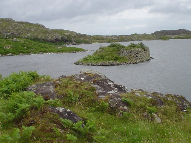
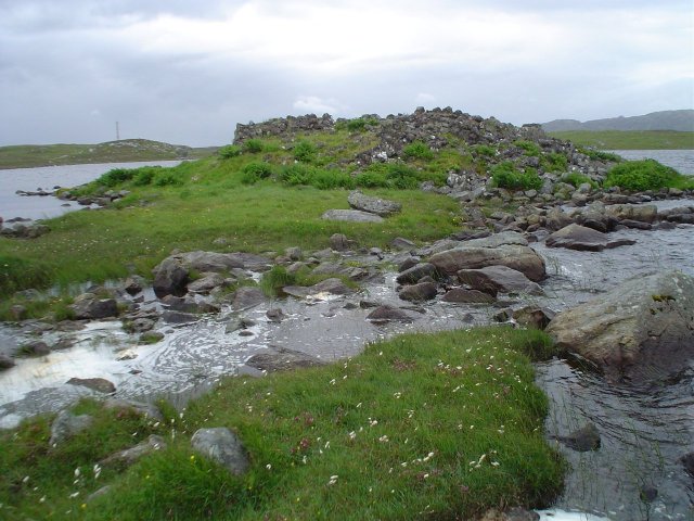
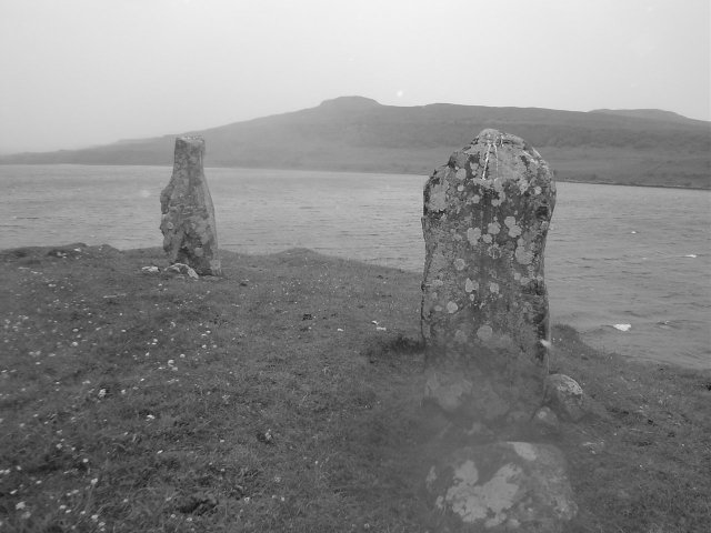
Eigg standing stone — Fieldnotes01.07.03ceEigg is the second largest of the small isles after Rum. The other small isles are Canna and Muck and none can be easily accessed by car ferry. On Eigg an island made famous by the fact the locals were able to buy back the land from there stay away landlord, this is a problem. The island is the most populous of all the islands with a princely population of 78. There is a four mile road stretching from the port at Galmisdale to the small village of Cleadale on the north of the island. A car ferry would encourage more visitors to the island and encourage more people to come and live there. It would also enable someone to get all the disused rotten junk away from the island. Eigg is a stunningly beautiful place but it really is threatening to become disfigured by the sheer amount of fly tipping which seems to be going on. The standing stone of Eigg is not to be confused with the monolith at the harbour commemorating the islands takeover by residents. This menhir stands proud looking over the new ferry terminal construction but the stone marked on the OS maps was about two miles further inland and pretty much in the centre of the island. Walking there was pleasant and not strenuous, this stone was certainly easier to find than the one supposedly on the island of Rum, it was just off the side of the road, its always nice when they are so conveniently sited don’t you think? After posing for the obligatory photographs we set off back along the road in the hope that it wouldn’t be too long before we reached the farm in which we were staying. After about half a mile we came upon another stone which didn’t look like it should have been there at all. This was smaller than the previous stone and was tilted at an angle. I again took some photos and named it the Eigg lesser stone ;-) Glencoe Standing Stone — Fieldnotes01.07.03ceEventually we ended up in Glencoe and were blessed in the fact that the set for the latest Harry Potter has been built up on the hillside. You can see Hagrids House, another construction that looks like it could be a passageway of somekind and, surprise surprise, a makeshift set of standing stones. After trying to sneak onto said set for a better look our plan was scuppered by one of the many security guards manning the site. Well, at least the view wasn’t too bad from the road. The cast and crew by the way had taken the weekend off from filming, lucky them. Ah well! Onto the famous Signal Rock! The Signal rock has a rather macabre history as it was from here that the signal was sent in 1692 to start the massacre of Glencoe when members of the Clan Campbell slaughtered their hosts the MacDonalds whilst they slept in their beds. The rock is to be found by following a path away from Glencoe town into a wooded glade. About a mile from the Harry Potter set is the rock and atop the rock midgies reign supreme. It must be said any trip to this part of Scotland must come complete with lots of insect repellent. As we rushed back along the path to the car, my eye caught a funny shaped rock just off the side of the path partly obscured by undergrowth and merging in quite well with the other rocks in the area. It looked like a standing stone although there is nothing to indicate this on the OS map. A puzzle indeed but it didn’t look like it should have been there so I took a couple of pics and have submitted accordingly, take a look and see what you think. Eyre — Fieldnotes01.07.03ceOn the way to the ferry we passed the standing stones at Eyre. Looking out over the loch they shared a field with a rather large group of inquizitive cows who seemed to take pleasure in following us around. We walked briskly up to the stones, lingered for a minute until the cows had lost interest and then walked briskly back. The Macleod Stone — Fieldnotes01.07.03ceHarris is a peculiar place, full of extremes. On the west coast are beaches which surely match the finest on earth, yet on the east and in the north, the landscape is barren and rocky. Stanley Kubrick in filming his masterpiece 2001 A Space Odyssey used the rocky terrain of Harris as a double for Mars. Testament indeed to the out worldly nature of the place. Across one of the beaches on the west side there is a signpost directing the traveller to a place known as 'The Macleod Stone'. An impressive monolith perched on a hilltop looking out over to Taransay, the island made famous by the BBC's Survivor programme. To get there is no chore although the beach does seem to stretch forever and apart from sinking in the soft sand and leaping over the odd channel it's a pleasant trip. However, this is Harris, a place renowned for its unpredictable weather. As we reached the stone, the wind started to howl and the rain buffeted down. We took our pics and struggled back to the roadside fighting the elements. Cnoc Fillibhear Bheag — Fieldnotes01.07.03ceWe wandered first to the impossible to pronounce Cnoc Fillibhear Bheag. The ground was marshy and the rain had started to pour down. Not that we were too bothered; to wander round all the Callanish circles had been another main point to the trip. A path links Cnoc to another circle a couple of hundred metres away known as Cnoc Ceann a’Gharraidh. A place with an equally long and difficult name and which boasts quite a cool triangular stone which we took the opportunity to shelter behind whilst the wind threatened to blow us into the bog. Callanish could be seen in the distance its stones like needles sticking up from the ground Cnoc Ceann a'Gharraidh — Fieldnotes01.07.03ceWe wandered first to (the impossible to pronounce Cnoc Fillibhear Bheag). The ground was marshy and the rain had started to pour down. Not that we were too bothered; to wander round all the Callanish circles had been another main point to the trip. A path links Cnoc to another circle a couple of hundred metres away known as Cnoc Ceann a'Gharraidh. A place with an equally long and difficult name and which boasts quite a cool triangular stone which we took the opportunity to shelter behind whilst the wind threatened to blow us into the bog. Callanish could be seen in the distance its stones like needles sticking up from the ground Callanish — Fieldnotes01.07.03ceNow we all know that Lewis is one of the places to go if your interesting in antiquity and stone circles etc. Lewis plays host to Callanish a wonderful place which evokes mystery and wonder. But Lewis also offers so much more, stone circles, brochs, duns, menhirs, Vikings, blackhouses, scenery and water lots and lots of water. We wandered first to the impossible to pronounce Cnoc Fillibhear Bheag. The ground was marshy and the rain had started to pour down. Not that we were too bothered; to wander round all the Callanish circles had been another main point to the trip. A path links Cnoc to another circle a couple of hundred metres away known as Cnoc Ceann a’Gharraidh. A place with an equally long and difficult name and which boasts quite a cool triangular stone which we took the opportunity to shelter behind whilst the wind threatened to blow us into the bog. Callanish could be seen in the distance its stones like needles sticking up from the ground. I had been there once before again in 1996, but my friend had not. I had been impressed with its size and complexity then and now my feelings remained. What went on here really? Why was it built? All these questions penetrate your head as you weave your way through the stones. It was 8pm by the time we got to Callanish, a good time it seems as all the crowds had long since left. A couple who were also wandering around told us that they had been there earlier that afternoon and the place was just heaving with a combination of tourists and druids. Druids! Of course! The summer solstice was only two days away. Not that we’d be here for that unfortunately, we had a tight schedule to work to. Maybe next year… Dun Carloway — Fieldnotes01.07.03ceDun Carloway is the most impressive broch in the Western isles and next to Mousa Broch in Shetland probably the most impressive in Britain. It was here that we stopped off first. I love brochs they're great, you can fight your way through wind and rain to get to them and when you finally get inside you can fell sheltered and safe. Most brochs originate from the Iron Age and were fortified farmsteads. Brochs could house people and animals inside and keep stores for weeks maybe even months. Dun Carloway dates from the 1st century BC and is situated on top of a hillock overlooking its manor. A wonderful place Loch an Duna — Fieldnotes01.07.03ceThere are all sorts on the Western coast of Lewis. Most are ‘blink and you’ll miss it places’ such as the unsignposted Loch an Duna Broch, the remains of which lie on a small island linked to the mainland of the loch by a ever more waterlogged causeway. Theres another one on a loch just a few miles up the road. The loch at shader, itself overlooked by the remains of a chambered cairn known as Steinicleit. Steinacleit — Fieldnotes01.07.03ceThere are all sorts on the Western coast of Lewis. Most are ‘blink and you’ll miss it places’ such as the unsignposted Loch an Duna Broch, the remains of which lie on a small island linked to the mainland of the loch by a ever more waterlogged causeway. Theres another one on a loch just a few miles up the road. The loch at shader, itself overlooked by the remains of a chambered cairn known as Steinicleit. Opposite Steinicleit (which could date from 3000BC) past the loch is the huge monolith of Clach an Truseil. An absolutely huge stone which now, I was reasonably surprised to note had a picnic bench not too far away from it. Dun Cromor — Fieldnotes01.07.03ceDown the road from the hostel at Kershader we had heard about the remains of another broch at Cromor. The broch again was in the middle of the loch and again pretty unaccessible. It looked good though, you couldn’t see it from the road, instead we had to clamber over a hillock to sneak a peek. I again marvelled at the sheer wealth of history on these amazing islands. Clava Cairns — Fieldnotes01.07.03ceVery near, in fact practically next door to the battlefield (Culloden), is the ancient site of Clava Cairns. Burial chambers thought to date from the 3rd or 4th millennia BC. There are three of them and there all very impressive, cups marks can be found on various rocks and the place is in surprisingly good condition. Again we were blessed with the timing of our visit. We were the only people there, if we’d have had time we would have loved to have stayed a little longer. Aviemore — Fieldnotes01.07.03ceWe stopped at Aviemore on the way to feed and water ourselves and were pleasantly surprised to see another stone circle signposted from the road. We followed the signs and found it, in the middle of a housing estate. Not really the ideal setting for such an ancient place but I bet the houses next door are worth a bob or two as a result. It reminded me of King Orrys Grave on the Isle of Man. Again the ultimate sacrilege had been allowed by ignorant planners, allowing development next to the monument. Brigantium — Fieldnotes01.07.03ceOur final stop was spent in Northumbria at a place called ‘Brigantium’. There is such a wealth of archaeology in the county that is quite difficult to get to, but the people in charge of Brigantium have produced mock ups of some of the famous sites to show people what the county has to offer. One of the sites is though (they boast) quite real. That of a hunters rock shelter that dates well into the Mesolithic. Flints had been found there during excavations and various slabs look as if they have been placed. Clach Stein — Images24.06.03ce
Clava Cairns — Images24.06.03ce
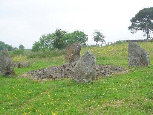
Three Kings — Images23.06.03ce
Brigantium — Images23.06.03ce
Glencoe Standing Stone — Images23.06.03ce
The Macleod Stone — Images23.06.03ce
Dun Cromor — Images23.06.03ce
Loch an Duna — Images23.06.03ce
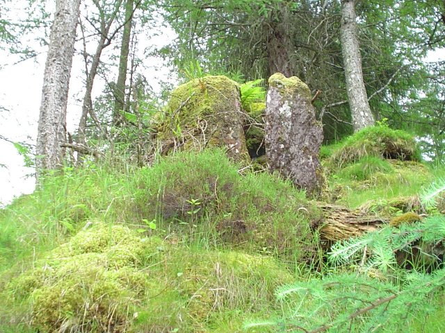
Steinacleit — Images23.06.03ce
Eyre — Images22.06.03ce
|
27th June 2003ce Edited 1st July 2003ce
notjamesbond's TMA BlogLatest TMA Blog Posts
|
Comments (0) |
|
| You must be logged in to add a comment | |