|
|

|
Latest Posts — Weblog |
Some useful Spanish phrases (Mallorca final part!) |
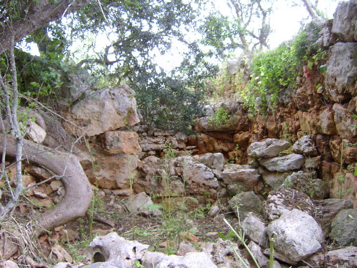
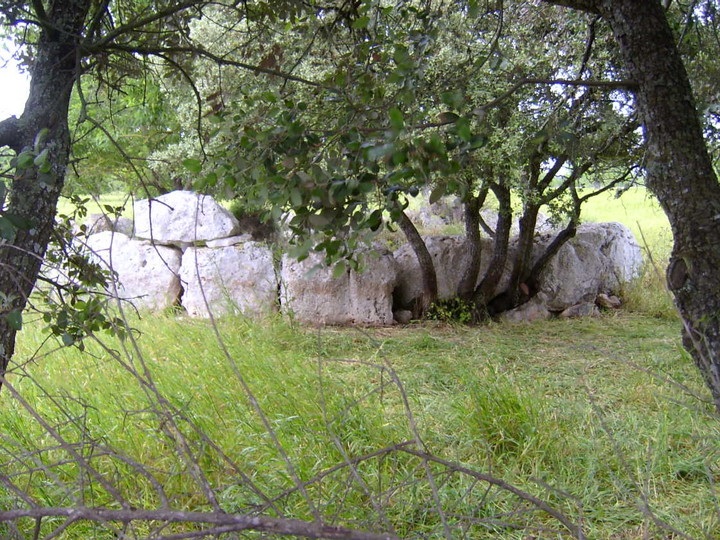
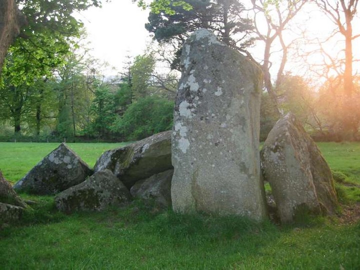
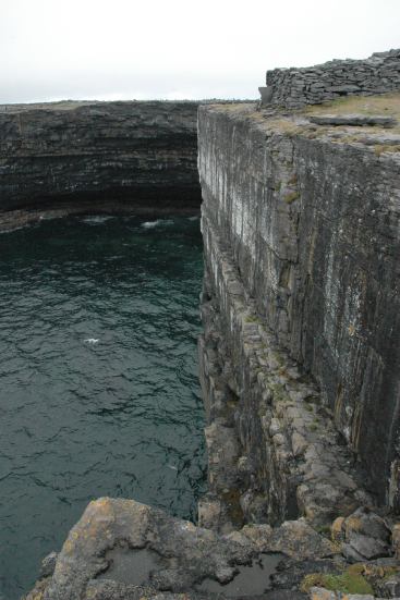
Some useful Spanish phrases (Mallorca final part!)Wednesday 3rd May continued ... Feeling reasonably confident with our map reading, instruction understanding, and stone spotting skills by now, and with the return of the sunshine - hurrah! - we decided to search out the naviforme at Can Roig Nou. From the southern town of Felanitx (a great name for an Asterix character?!) we took the PM512 towards Campos del Port but after about 1km turned off to the right onto the Cami de Son Mesquida. After about 4km, and just before Son Mesquida itself, we took a left onto Cami de Pedreres and almost immediately left again following the signpost to Can Roig. Before long, there was a right turn with a sign saying "Formatges" which we followed, past a building with huge lettering "Santa Son Mesquida" on it. There's a house numbered 2098 to the right, and after this we kept to the left down a farm track - with a substantially sized ostrich in the field to the left - and pulled up in the farmyard. The directions we had said to ask permission at the farm. There were 4 dogs loose in the yard, 2 of them quite big and one of those quite scary looking, so we sat in the car for a few minutes pondering our next move. Then two men appeared from one of the farm buildings, so I got out and waved, and shouted "hola!". That's part of my very limited command of the Spanish language (of course in Mallorca, it's a Catalan dialect, Mallorquin, that's spoken, rather than Castillian Spanish, but trying either is appreciated). I followed that up, as he approached, with "No hablo espanol. Ruinas prehistoricas?" and with a beaming grin, he shook my hand and pointed into the farmyard. A bit of sign language confirmed that it was OK to leave the car just where it was, and accompanied by the now playful and friendly dogs, we all headed along the track, past the cow sheds and into the field beyond, where we found the naviforme. Can Roig Nou — Images31.07.07ce
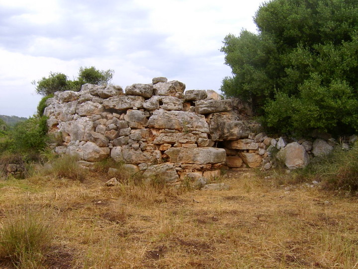
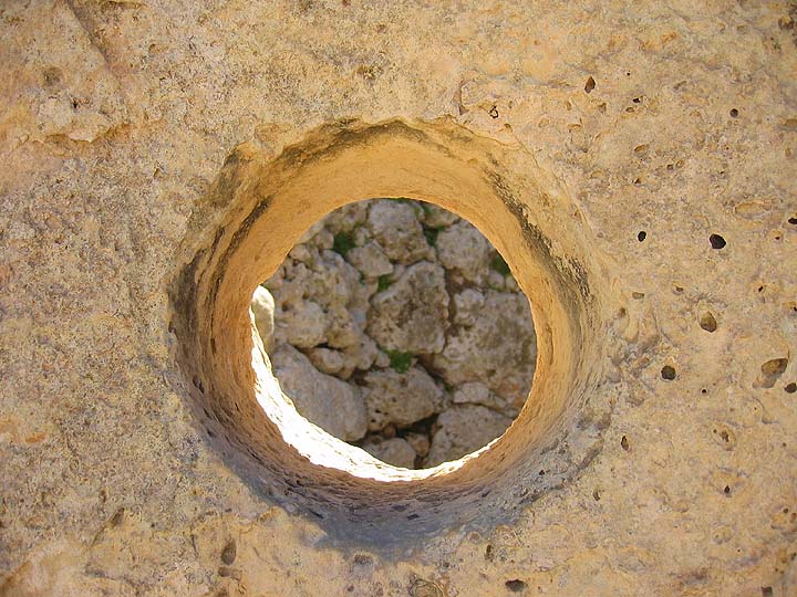
Overdue explanation time - a naviforme is a boat or enlongated horseshoe shaped structure, similar to the navetas on nearby Menorca, only rather than being contructed entirely of stone, the naviformes had a roof of wooden beams covered with branches and mud. This is one of the most impressive - many others have only their foundation stones remaining, for example at Hospitalet Vell and Es Closos de can Gaia (see the second half of my blog no 1 for Mallorca, Browsing the Balaerics again ...). It's the remaining one of three; it was the middle one, and the wall to its right contains some of the stones from its neighbour. The inside is impressive, with the walls way taller than us; the interior dividing walls are thought to be later, maybe Roman, additions, and the construction of the apse has lead archaeologists to believe there was originally an attic space. Can Roig Nou — Images31.07.07ce
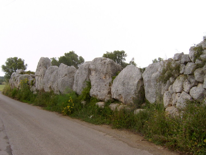
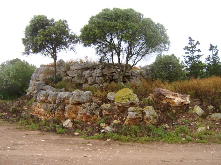
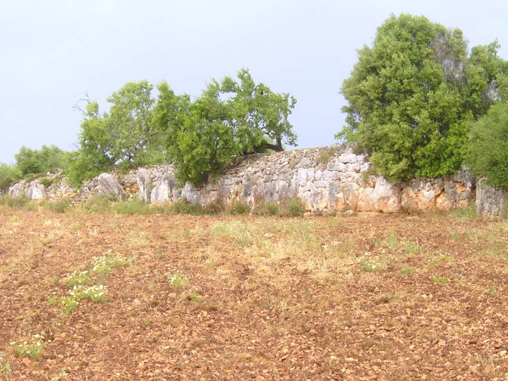
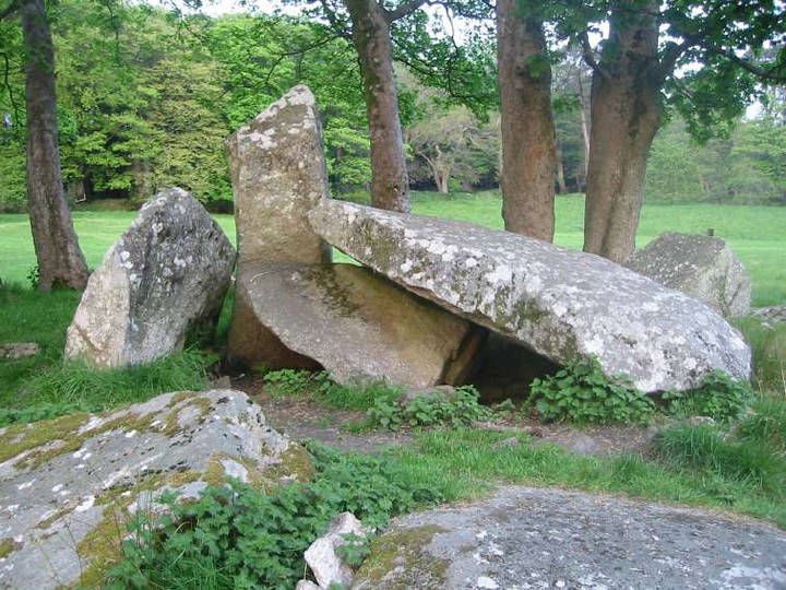
Beardy went to have a look at what was round the left side and beyond the naviforme, and came back followed by a herd of goats; this and the fact the our guide had waited for us meant we didn't check out the surrounding landscape, but headed back to the car. "Muchas gracias, senor!" We retraced our steps onto Cami de Son Mesquida, but turned away from Felanitx and towards Porreres and less than 2km later, couldn't miss this: Es Pou Salat — Images31.07.07ce
Just after the magnificent wall, the road drops down, and there's a handy parking place next to a well. We went to investigate, and behind the wall a series of rooms could be seen Es Pou Salat — Images31.07.07ce
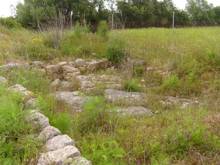
and in the field to the south, the remains of a talaiot and a wall beyond that - both inaccessible. The (as usual, almost illegible) well hidden information board identified the site as the poblat of Es Pou Salat. Rumbles of thunder in the distance and increasingly threatening clouds persuaded us to start heading for home via the town of Villafranca de Bonany, but we realised there were a pair of talaiots just off the road (the C715, which is in the process of being turned into dual carriageway for much of its length and roundabouts and ring roads are cropping up all over) so took the PM511 to the right back towards Felanitx. After about 2km, we took a track to the left just before the road bends to the left, marked Privado PM10815, and headed towards the talaiots of Son Pou Vell, also known as Sa Clova des Lladres, at the top of the field guarded by a thousand thistles. The nearer one is quite ruinous  but the other is better preserved and offers tantalising glimpses of its central column  though its entrance is blocked.  Handy hint for the ladies at this site - don't wear a skirt. There's a four foot wall to climb and those thistles in the field will leave you scratched and bleeding. With the storm brewing and advancing, we went back to our hotel for a final evening, packed, and set off early on Thursday. Our flight back wasn't till the evening, and the hire car not due back till late afternoon, so we'd planned to check out the south west of the island before heading back into Palma. We'd been looking forward to the poblat of Capocorb Vell, with its three circular and two square talaiots, all of them huge and well preserved. From the town of Llucmajor, take the road signposted to Cala Pi, and it's signposted from there. On a bend in the road, you can't miss the huge sign and there was a car park on the other side of the road ... completely empty. The main gate was locked, and the walls surrounding the poblat had branches laid over them to discourage climbing over, so all we had were glimpses over the wall and through the main gate.  The site has a 2 euro entrance fee and a bar for visitors. The sign outside stated opening times of 10:00 - 17:00. We went back up the road and asked when it would be open at another bar - "mañana". A useful phrase to know in Spanish, or indeed useful information to have when planning a trip - "jueves cerrado" means closed on Thursdays! We stopped briefly to check out one of several talaiots only about 100m to the south  off a private road belonging to the house called Capocorb Vell, but then with time ticking on, decided to head north and negotiate the mad Palma traffic, road works and one way systems, and after a well deserved pint, got a cab to the airport. A thoroughly enjoyable week - but so much more, not just the so annoyingly shut Capocorb Vell, to see. We'd visited less than half of the sites I'd turned up in my research, none of those in the north west of the island, and if we'd checked out all those three-little-red-dot markings on the map ..... Don't write Mallorca off as just another package holiday destination! Get one of the many cheap flights and a car, and go exploring. I'm tidying up, decyphering and adding to my notes, and if you plan to visit the island, drop me a mail and I'll share the detailed info with you. Es Pou Salat — Images31.07.07ce
|
14th May 2006ce |
More Mallorca! |
More Mallorca!Wednesday 3rd May ... weather forecast - cloudy and possibly the occasional shower. As we set off, I looked at the clouds and wondered whether bringing a coat would have been a good plan. Not many miles south, the heavens opened, the rain lashed down, and the wind whipped the trees into a frenzy. But nothing was going to stop us checking out south east of the island. We decided to head for somewhere we were sure we could find, so followed the directions in TME to Ets Antigors, near the town of Ses Salines in the southern most tip of the island. There's a wide path from the road into the site, but we went first through a gap in the wall to the right of this to check out Sa Talaia Joana, the circular talaiot situated just outside the poblat. We climbed up and side and were almost blown off the top.  Soaked to the skin, we headed into the main body of the site, past a water silo  and as usual found the information board in disrepair.  When the site was excavated in about 1915, underground enclosures were found, more talaiots and a sanctuary, but much of this was reburied. Today the site has some impressive wall  a number of clapers - piles of stone covering other structures -  and talaiots - overgrown but offering a glimpse of the central pillar. Sa Talaia Joana — Images31.07.07ce
It was still very wet and windy  so we didn't spend as long as we might have done here, but headed back to the road and despite the large private keep out signs, went into the farmyard beyond the site to take a better look at Sa Talaia Joana  whose entrance is on its far side, away from the poblat.  There were people working in the farmyard, but they didn't seem to object to us being there. Then we went back through the town of Santanyi, and took the C714 north towards Cas Concos des Cavalier, but after only about 1km took the first right turn. This narrow road bends after maybe ½km, and glancing into the field to the left, I spotted a magnificent section of wall  and following the bend round, the talaiot of Ca'n Jordi set back from the road.  This talaiot has a magnificent, if precariously balanced, central pillar Ca'n Jordi — Images31.07.07ce
 and an unusual zigzag entrance runner  There appeared to be the remains of some walls or rooms adjacant to the talaiot, but an alarmed, and equally alarming when it popped out of the undergrowth, chicken with chicks was in residence, so we didn't investigate too closely, but went into the next field where the wall continues. Ca'n Jordi — Images31.07.07ce
Sadly, the talaiot and the sections of wall are all that remains of the poblat Ses Talaies de ca'n Jordi. |
13th May 2006ce |
Templehead Pt.2 Mnajdra |
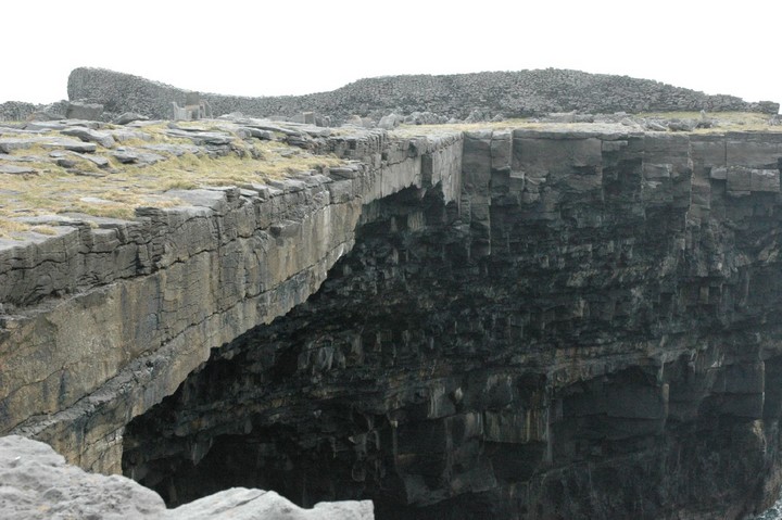
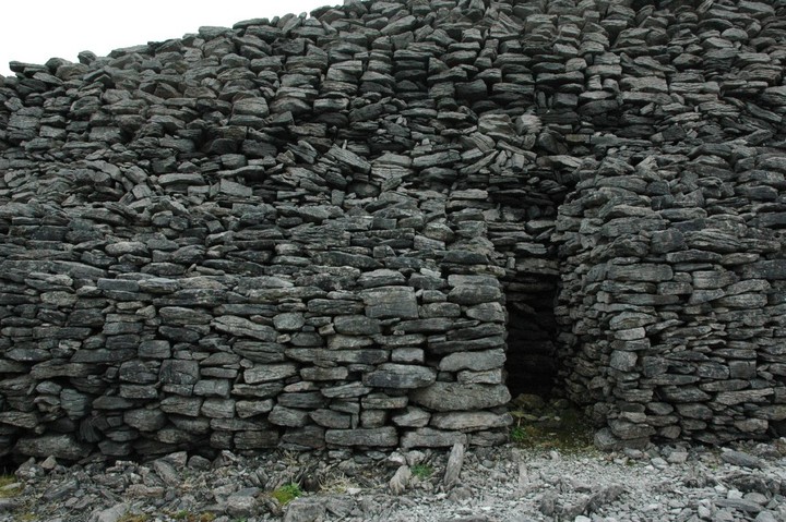
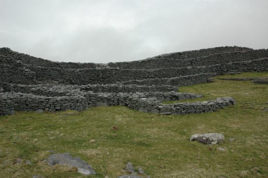
Templehead Pt.2 MnajdraMnajdra The last time I was here the temples they were still being repaired after they were horrifically damaged by hunters at Easter 2001. The temples were fenced in locked up and no amount of pleading could get me through the gates. I had to satisfy myself with a mooch around the perimeter and a prolonged sit on the hillside behind the monuments. As I walked up to the gated perimeter fence that separates the Hagar Qim temples from the path to Mnajdra I noticed some men working, as I got close to them I could see that they were putting razor wire onto the top of the already substantial fence. The temples have survived the ravages of time, environmental collapse and a couple of thousand years of conquest and invasion. It's extremely saddening that these unique structures, the oldest stone built structures in the world, have to be protected against the all too real threat of vandalism by local people. I won't let this dishearten me, today is my temple day. On the hillside between Hagar Qim and Mnajdra are a series of deep cavities that have been carved into the rock which are known as the Misqa Tanks It is thought that they were used as water cisterns for the prehistoric community in this area. It is possible to walk up to the tanks but today, despite having plenty of time, I declined not to do so. Today was not not a day for traipsing, I had to remain true to my purpose. Hagar Qim is a spectacular site but Mnajdra is where I want to be. Mnajdra is a difficult site to get your head around. It is actually three temples facing into a common oval forecourt.   The smallest and oldest temple is to your right as you approach the site. It is described as a simple trefoil of the Ggantija phase. The second and third temples are of the four apse form and that's about as technical as I'll get. I sat down and let the pure, deep joy of this place wash over me. The temples are nestled into a hollow in the hillside when you look uphill you see an endless blue sky, when you look downhill you see an expanse of deep blue sea. If you walk from the sea to the sky you will find the temples tucked into their niche somewhere in the middle. Each temple is a different experience but it is all held together by the land and seascape. The Temples, the hillside, the sea, it's just all too perfect.  If you ever fortunate enough to visit Mnajdra, I would strongly urge you to go there as early in the morning as possible and try to experience the place without the distraction of strangers. Mnajdra is one of the few places on earth that really reaches down inside of me. I'm afraid I'm not eloquent enough to elaborate on the feelings and emotions that this place provokes, so apart from adding a few comments to my photographs I'll leave it at.  The beautiful gnarly exterior. The naturally holed stones have their man-made counterparts within the temple.  An oracle hole. There is a secret chamber behind this one.  Another oracle hole next to a 'portholed' side chamber     Altars  A libation pit. These pits are commonly found on the steps of temples and chambers throughout the islands.   Filfla is never far from view   Lovely, lovely pitting  An inner apse  The Temple carving. The location of the carving can be seen just beside the entrance on the picture above of the inner apse.  Mnajdra — Images09.10.07ce
|
 Posted by fitzcoraldo
13th May 2006ce |
Kilmashogue and Larch Hill |
Kilmashogue and Larch HillFinished work at 6 and headed for home. Got the ixus and headed for Kilmashogue wedge tomb. Plans were to see Kilmashogue (very easy to find) and then double back and see Kilakee wedge tomb (not very easy to find and didn't want to spend my whole evening lost in Massy's forest). Kilmashogue Wedge Tomb — Images15.05.06ce
Kilmashogue was a surprise. The usual detritus that's found in the Dublin mountains was an annoying distraction. I've no objection to people camping out and enjoying a few beers around a campfire, but come on, clean your crap up after you. (This has been a recurring annoyance for me since moving to Bohernabreena – the amount of burned-out cars, the ubiquitous empty beer cans and just the general disrespect and dumping of peoples' shite around the beautiful countryside of the Dublin/Wicklow mountains... rant, rant, rant.....) After doing a small clean up I surveyed the site. The trees block any of the significant views but enclose the tomb in a relatively private space. Did I find peace here? A little, after I calmed down and focussed on the stones. I climbed a beech tree and got a some nice shots of the tomb from above and decided to head for Kilakee. Looking at FourWind's notes for Kilakee I decided against it and opted to sneak into LarchHill scout camp to see if I could find the portal tomb there (the camp was quiet). Kilmashogue — Images12.05.06ce
I had spent some time in the camp as a youngfella scout and know my way around the place. How did I miss this beautiful relic of our past back then? I can only say that I was using different eyes. The immensity of the capstone was breathtaking. How did they get it up there? I was moved by this monument; the trickle of the little brook; the small copse of large larch trees; the huge ancientness of the collapsed stones. I got the same feeling here that I've felt at a lot of these sites: sadness and loss. At Ballymaice last Sunday, on Seefin Hill, around Dowth – a feeling of excitement and respect tinged with that sadness and loss. Oh well. So where next? Maybe, if I have the time, I'll try Kilakee. |
 Posted by ryaner
12th May 2006ce Edited 26th September 2006ce |
Templehead pt1. Hagar Qim |
Templehead pt1. Hagar QimEaster Monday Today was to be the most important day of my holiday. I got out of bed early and fortified myself with a couple of toasted doorsteps of beautiful buttered hobz bread washed down with a large mugful of strong Maltese coffee. I walked out of the villa into the beautifully quiet Maltese morning. Today was my temple day, the whole day was to be given over to my Maltese trinity. Hagar Qim, Mnajdra and Tarxien. Just saying the words filled me with excitement. My plan was to get to Hagar Qim for bang on 9 o'clock and be there when the gates opened. It was a twenty minute drive, I left the villa at quarter past eight 'just to be sure'. The last time I drove to Hagar Qim was three years ago and I found myself driving through a labyrinth of narrow, dusty, potholed lanes that ran between a series of small firework factories, this time I was determined stay focussed and not get lost. Guess what? I managed to get myself to Qrendi, the nearest town to the temples, and then ended up in the self same maze of farm tracks and firework factories. What the hell, I knew I was only a couple of miles from the temples and travelling in the right direction. I arrived at the Heritage parks car park at about ten to nine which was just enough time to grab my kit and give the ancient tatty capped car park custodian a 'voluntary contribution' to look after my car. My plan was simple and selfish. I wanted to be the first person of the morning at either Hagar Qim or Mnajdra or both. I was having a Verruca Salt moment 'I want a temple to myself and I want it now!' As it turned out I ended up having both sites to myself, the first guided tour did not turn up at Hagar Qim until I was walking past it on my way out. Hagar Qim. You approach the temple from roughly the south east and the façade is stunning, its asymmetry is puzzling but very appealing.  The beautifully quarried orthostats that surround the entrance seem to degenerate into large irregular rotting monoliths looking for all the world like a gobful of rotten teeth.   It makes you wonder what was going through the architects mind here. These large blocks draw the eye away from the temple entrance and towards the sea where your gaze finally settles on the beautiful rocky isle of Filfla in the distance. The huge irregular orthostats appear almost like temple guardians looking out to sea and protecting the faithful from what? The primitive folk who lived beyond the horizon? As the temple is located on the top of a hill it would be interesting to see it from the sea. Would these megaliths appear like giants looking out over the sea? Their wild weathered nature also contrasts with the regular smooth blocks of the entrance. Perhaps the architects and stone masons knew that the blocks that faced seaward would eventually become gnarly and weathered and erected them as a gesture to whatever deity controlled the elements. All the winds still have names in Malta.  There are a corresponding set of huge irregular monoliths on the opposite corner of the temple and it is the largest of these that you can see looming over the temple as you approach it, another guardian perhaps. One of the unusual things about Hagar Qim is its' hilltop location, the large orthostats are visible from all around the monument including the nearby Mnajdra temples. I have read so much about these temples that walking into Hagar Qiim is a very comfortable feeling for me. I feel warm and happy and I have the place to myself.   The temples are quite confusing in their layout but I'm not here to study the floor plans, I'm here to be happy and spend some time amongst these big old stones and I'm getting that in spades.  Catching a glimpse of Filfla is enough to bring on deep joy.     A few of the carved stones are replicas but don't let this spoil your appreciation of their beauty. I have seen the originals in the Museum in Valletta are there is no difference. There is some debate as to whether this temple is a four or five apsed structure it's nice to know that there are some things that we still cannot define or label. A few yards north of the temple is a second five apsed temple which if anywhere else would get a great deal of attention, unfortunately here it is totally eclipsed by it's beautiful exotic neighbour.  I wandered over to this substantial but forgotten neighbour and sat a while within its walls and tried to soak up a little of it's flavour. It almost felt like an act of condolence. Between this temple and the large temple is another structure which again is quite substantial but formless. No one is quite sure as to what the purpose of this building was. It is sometimes called 'the priests quarters'. A prehistoric parochial house, that notion really appeals to me.  It was now time to move on. I walked the few yards to the perimeter fence and the path that leads down the hillside and look out upon one of my favourite views in the world, the Mnajdra temples nestled in a hollow in the cliff below. 
|
Posted by fitzcoraldo 11th May 2006ce |
Malta. Easter 2006 Part III |
Malta. Easter 2006 Part IIIEaster Sunday We had planned a family day out to the beach for today but me and my lad were up early and decided to sneak out to have a look at the nearby Xemxija rock cut tombs. My lads not one for megaliths but loves his wildlife. Over the past few days we had found grasshoppers, geckos, false scorpions, multi coloured beetles and a praying mantis so the prospect of mooch around the Maltese countryside was enough to convince him to come with me. The tombs at Xemxija are significant for a number of reasons. They were excavated by Evans in the 1950's and yielded a whole host of material. The majority of the finds dated to the Ggantija phase but there were also some sherds of Tarxien pottery and some later Bronze Age burials were also found along with some axe amulets. Another feature of these tombs is that some of them are lobed which indicates that there is probably a link between the lobed nature of the caves and the similar layout of the temples.  Plan after Trump There have even been attempts to link this lobed shape to the shape of the 'fat lady ' or goddess figurines that have been found on the islands. The are some examples here: http://web.infinito.it/utenti/m/malta_mega_temples/TempleFig/%20Pres%20Fragm/index.htm It has been suggested that the temples could be a reflection of a Neolithic fertility goddess but this is just one theory of many. Here's a few links. I'll not comment on the content. http://www.infohub.com/Articles/20010219.html http://www.carnaval.com/goddess/ http://www.goddesstourstomalta.com/sp.html http://www.sorcerers-apprentice.co.uk/maltamss.htm Another reason why the tombs are important is that many animal bones were excavated here giving us a good idea of what animals existed on the islands during the Neolithic. Bones found included sheep, goats, pigs, cattle, horse, dog, cat, deer, rabbit and hedgehog. The tombs themselves are not too difficult to find and you can drive to within a dozen yards of them. To reach the tombs you need to turn off the main road (route 1) at the roundabout at the top of the hill at Xemxija, there is also a church on this roundabout. Turn into Xemxija and drive past the derelict hotel complex to the top of the village. The tombs are beside Triq bil-Preistorja which is the last road at the top of the hill. Park on this road. The tombs are at the top of the small rise about half way along the road. When we visited we drove to the end of the road and then when mooching around the fields on the hillside until a very nice lady pointed us in the right direction. A word of warning, You need to keep your wit about you in this area . It seems to be very popular with hunters. I used to drive past this hillside on a daily basis and there were always at least a couple of four by four vehicles parked on the hillside. The tombs themselves are basically just holes in the ground. I stuck my head into most of them and was greeted by the hum of wasps or bees in three of them which kind of put me off going any further into the tombs. What I did find remarkable was that the tomb builders had picked a horizontal surface to tunnel into.    The limestone here is very hard so excavating the tombs vertically in to the bedrock must have taken a considerable effort. It would have been far easier to cut horizontally into the strata a little lower down in the Mistra valley where there are cliffs and natural caves. Which leads to the question why all the effort? What was the significance of this particular hill?  The hill is not the highest in the area but it does have good view over St Paul's Bay and the coast beyond or at least it would have if the village were not in the way. It is possible to pick out the location of the Buggibba temple in the distant sprawling resort.  There is also a good view over the Mistra valley to Melliha which is situated on top of the next significant hill top. All in all the Xemxija tombs don't offer much in the way of spectacular remains but if you are wanting to build up a picture of Maltese Prehistory and maybe understand why certain locations were chosen then it's worth coming here, sitting yourself down and having a good look around you. I would never describe Malta as a pretty place then again I would never describe the Maltese landscape as boring. I'll take interesting over pretty any time. My lad would say that it's worth visiting the site because there are lots of huge ant's nests and you can spend time feeding dead insects to the ants. A Maltese Proverb Qabda trab, erba' kaptelli u harja f'wicc kull ma kelli. A handful of dust, four capitals (of a column) and shit on all I possessed. |
Posted by fitzcoraldo 11th May 2006ce |
Ggantija - The Giant of Gozo |
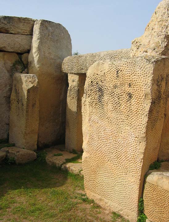
Ggantija - The Giant of GozoEaster Saturday Today's trip was a full family affair, a trip to Gozo. The last time I was in Gozo was when I was six years old so I was really looking forward to this. We were up bright and early and off to the ferry port at Circewwa. The ferry ride is lovely and by the time you've eaten your delicious Maltese Eccles cake and washed it down with lovely Maltese coffee your there. We spent the morning in Victoria and had lunch at a lovely café in the middle of the market and then walked it off by and taking a turn around the battlements of the citadel. I'd recommend a trip to the citadel, it's easy to find as it is in the centre of Victoria. If you walk around the battlements you will be rewarded with a 360 degree panorama of this lovely island, you will also gain some understanding of how Gozitan settlements developed from the flat topped limestone Mesas that are the main topographic feature of the island.  When it comes to 'looking at rocks' my family and I have an unspoken agreement, they are happy to tolerate my obsession as long as it doesn't involve me dragging them around a bunch of sites or trying to convince them how wonderful these places are. So I had a choice to make, I knew I could get away with taking them to one prehistoric site on Gozo. Gozo has many prehistoric sites from standing stones to temples to Dolmens, so where would it be? without a doubt it had to be Ggantija. Ggantija is signposted and quite easy to find. Once you get to Xaghra just look for the large car park and you know you're there. When walking towards the temple it is worth looking at the surrounding walls. Not far inside of the main gate there are some large orthostats that have been interpreted as possibly another structure associated with the main temple.  Another feature worth looking out for is The North Cave, which is a cave just at the top of the site. The cave has been interpreted as possibly starting out as a rock cut tomb which then became a rubbish pit for the temples.  As for Ggantija itself, the scale of the walls is overwhelming. Mr Cope is spot-on when he refers to the walls as Cyclopean.    I just had to stop and take it all in. This structure is five and a half thousand years old and was build by people who had no knowledge of metal. These stones were cut, erected and had fallen long out of use long before any Eygyptian had even considered building a pyramid. Of course the Maltese temples were not the first structures in Europe, we on the margins of western Europe had been erecting our megaliths and building tombs even before the Maltese culture had risen and flourished, but what is important about these these Maltese and Gozitan temples where designed and built as public buildings, they had torba floors, the walls were plastered, they contained ornately carved decorative stonework as well as carved features such as holes for door posts, animal tethers, libation bowls etc.     I could bore you here with a long explanation of the lay-out of the temples but I'll spare you that. In a nutshell you have two temples enclosed by a huge wall, the older, western temple has five apses and the eastern temple has four plus what the guidebooks call a 'niche'.   The Ggantija temples should not be seen in isolation, this part of the island has many prehistoric monuments. The Brochtorff Circle which is now known as the Xaghra circle is just on the other side of town, the Santa Verna temple lie 700 metres west of town and there are various other bits and bobs including Ta Ghejzu, a cave that yielded pottery from the Ggantija phase and has the possible remains of a temple on it's margins.  Ggantija is an extremely important site and is treated as such by the Goitans, it has had the full heritage treatment but is not over the top, this is no 'Stonehenge-site-in-cage' it is a site you can still interact with and come away feeling that you've had a personal experience. As temples go Ggantija is definitely a world class site and my second favourite temple of the islands. My only regret from my visit to the temples was that I didn't buy some of this fella's capers on my way out. 
|
Posted by fitzcoraldo 10th May 2006ce |
Mallorcan mysteries |
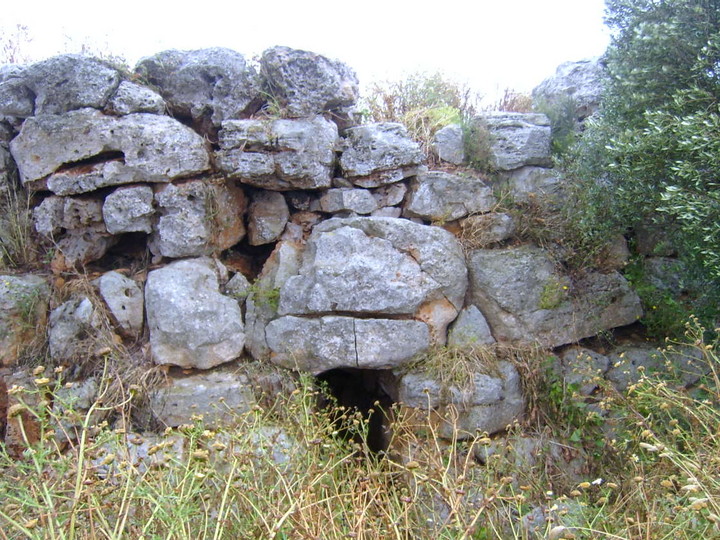
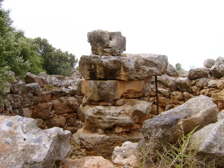
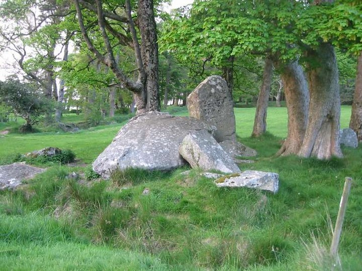
Mallorcan mysteriesAnother slightly later than planned start (that free tequila again!) meant we decided to stay local on Tuesday, and try again where we'd failed earlier in the week. So after lunch, we set off for Ses Paisses, only a 20 minute drive away. We took the signed way off the roundabout just outside the town of Arta, saying "please let it be open, please let it be open" and it was! A brand new sign had appeared screwed to the gatepost, announcing opening hours of 10 - 12:30 and 14:30 - 18:30 from April to October, the gates were open, and having paid the entrance fee of 1,55 euros each, plus 2,05 for a guide leaflet, we followed the wall round to the magnificent entrance we'd only been able to glimpse through the trees earlier in the week. And what an entrance!  I was expecting great things. We wandered round the area just inside the wall, checking out new excavations, and then followed the rather neatly signposted route through the trees into the main body of the site - past the pillared rooms  round the bottom of the great talaiot and eventually up the side of it to admire its construction and gaze down into the tower.  The route then takes visitors past one of the alternative entrances to the settlement, and past some more pillared rooms, and then back past the talaiot and out again. The sun was shining, there were only another 4 people there, that main entrance is impressive ..... but the place just didn't grab either me or Beardy. Maybe we'd been so amazed by the structure and scale of Son Fornes the previous day that nothing would have done. Checking out the information leaflet, I was mystified - there's a page which explains the different shapes of talaiot and gives examples and pictures: square is Son Serra de Marina, which can also be called Santa Margalida - no problem with that - but the round example was "circular talaiot in Sa Canova". The introduction to the island in TME mentions the great talaiot of Sa Canova, and that it's ruinous now, and therefore not included, apart from a picture - only not a picture of the same structure I was looking at a picture of (grammar pedants, yes, I know, but it makes sense to me!). Checking back at my translated notes, the picture in TME is of the square talaiot of Canova d'en Morell but about 300 metres away from this, is the round and very impressive looking talaiot of Sa Clova d'es Xot which was the one in the Ses Paisses guide. Hmmm. I speak very very little Spanish (ie I can order a beer!) but can understand a bit more, so tried to have a conversation with the guy manning the ticket booth - I pointed to Sa Canova on my map, and the picture in the guide, and he told me it was on private land, and seeing as we'd been along the road where you should be able to see both of these structures a few days before, we just shrugged and decided to make a second attempt at Es Claper des Gigant - nearby and signposted. Again - the gate was open - hurrah! We parked up and followed the pink sign almost hidden in bushes to the left of a building and came out on the path round a golf course. Almost immediately, there's a path off to the left with a wooden sign for "Es Clapers" so we followed the way through a wooded area until we came to a gate and turned right at the T head through it on the basis that my instructions said the talaiot was on high ground. There were gardeners out on the wide sandy track cutting back the undergrowth, and a few minutes walk later we caught a glimpse of some stone ahead so took a left fork off the main path and after a short climb found ourselves here:  Just to the right of the clearing (still being cleared by yet another gardener while we were there) was a talaiot  with a path up its side to let you see its centre  and what appears to be steps in the internal wall, as we'd seen in Son Fornes talaiot 2.  The surrounding area had walls  A beautiful spot - apart from the sounds of quarrying coming the far side of the golf course. But then I dug out my notes again, and realised we were actually looking at the poblat of S'Heretat, not Es Claper, after all. The surrounding area was still quite overgrown, but we tried to find the other structure mentioned in my research notes, and although there were several piles of stones on the way, we didn't find anything identifiable on the way back to the car. A day of confusion! Ca'n Jordi — Images31.07.07ce
|
9th May 2006ce |
Malta. Easter 2006 Part II |
Malta. Easter 2006 Part II14th April Good Friday I decided to have a run over to the west coast and visit the Dingli cliffs followed by the famous Clapham Junction Cart Ruts. There isn't a great deal for the prehistoric purist at Dingli, there's a nice church and some other bits and bobs but what drew me here was the height of the place. At 250 metres above sea level Dingli Cliffs are the highest point of the islands. On the landward side there are beautiful vistas of the island and views looking over to Gozo. It is said that on clear autumn days you can see Mount Etna on Sicily from this point. To your west is the sea and the beautiful uninhabited island of Filfla. Beyond the horizon lies the North African coast.  I guess if you want to see prehistoric cart ruts then Misrah Ghar il-Kbir aka Clapham Junction is pretty much the place to go. However cart ruts are not just a Maltese phenomena, they can also be found in Sicily, Spain Sardinia Greece and France but I guess the reason why the Clapham Junction cart ruts have become so famous is that there are so many of them in such a small area. The site can be a little tricky to find especially if you are coming at it from the Dingli cliffs. Your safest bet is to get on the Rabat to Busket gardens road and look for an area between two large modern quarries. The cart ruts themselves are pretty remarkable when you consider their age. I should mention something here about the age of the ruts. There is a lot of debate on this subject. There are a number of rock-cut Punic tombs in this area and at least one of the tombs cuts through a set of cart ruts. The tombs have been reliably dated a have been dated to the later centuries BC. This means that at least some of the ruts are older than this date.   Punic Tombs cut into the bedrock Most of the experts seem to agree that most of the ruts are pre-Punic but opinions differ from this point onwards. Some argue that the ruts are from the temple period whilst others, including Trump favour a Bronze Age date. The debate around the use of the ruts isn't much clearer than the dating debate, however many experts seem to favour the idea that the ruts were made by some kind of vehicle but after this there seems to be all sorts of opinions. Trump states that 'Wheeled vehicles do seem to attract the least serious objections'.   Ok I can accept that the ruts may have been used for vehicles but why were so many parallel ruts needed? At Clapham Junction there are multiple tracks parallel tracks, all running in the same direction.  As a visitor I guess you could probably spend the best part of an hour following the ruts around this limestone plain, they are fascinating but I'm going to contradict myself here and tell you that I found them to be are pretty unremarkable and felt quite under whelmed. However, what I really did enjoy about Clapham Junction was the Ghar il-Kbir caves and the rock cut Punic graves. The caves are quite easy to find. Just walk a few couple of dozen yards uphill to the top of the limestone area and you're there. Back in geological time the caves were all underground but then as tends to happen with limestone, the roof of the largest cave or a series of caves collapsed leaving a large cavity in the ground with a number of caves many of which are interlinked, around the margins.  It's well worth scrambling down into the caves, they are lovely and cool and provide a bit of welcome shade from the Maltese sun.   The caves were occupied up until the nineteenth century and when you climb down into them you can see evidence of walls and entrances. No evidence of prehistoric occupation has yet been found in the caves but considering that a set of cart ruts start on the margins of the caves I'm sure this site would not have gone unnoticed by the prehistoric Maltese. |
Posted by fitzcoraldo 8th May 2006ce |
Mallorcan central circuit |
Mallorcan central circuitMonday 1st May Another sunny day dawned, and our shortlist of 10 sites were between the towns of Inca, Algaida and Manacor, in the centre of the island but north of the main C715 highway. As usual, we managed to make our approach from the opposite direction to our instructions, but, being right alongside the road, we had no problem locating the pair of talaiots of Es Racons. The one nearer the road has not been excavated, and is crumbling away  The one set back from the road is the more impressive  and having entered the talaiot the remains of the central pillar is visible.  The site was quite overgrown, but it was well worth going round the back of the second talaiot into the wood to see where a tree has grown into its structure, and to find the megalithic locker described in TME. With no information about what we could expect to find at Son Creixell or Sa Ritxola, both marked as places of interest on the map, we decided to head for the village of Costitx and soon found ourselves in a traffic jam caused by the local fiesta. The village was closed to through traffic, so we rejoined the PM324 to Inca and took the PM312 back down again to approach from the other direction - and then just before Sencelles we took the left turn to Son Fred.  The information board was just about undecipherable, and there were two huge mounds of sandy coloured rubble round the outside of the talaiot.  There's been excavations carried out here - the central pillar is propped and wrapped  and the area at the front has been dug to expose a step  but there's no way in through the unusual curved entrance passage.  The directions in TME are good for Son Fred - and it's easiest to find heading north from Sencelles. Our next site was to be the sanctuary of Son Corro, and the recommendation is to be travelling east to west, from Costitx to Sencelles, or you will do as we did, and miss the sign! The usual pink one has company - a white municipal sign which I believe dates the restoration of the site as having taken place in 1994. The sanctuary is on shelf overlooking fields   with six tall columns  forming a corridor to the shorter column, still used for offerings today.  The finds from this site include 3 life-size bronze bulls heads, now in the National Archaeological Museum in Madrid. Feeling a bit more confident with our navigational skills, we went back to Sencelles and took the PM314 south to Cas Canar. After the houses at Cas Canar, just as the road bends sharply to the right, we took the turning to the right and drove slowly on, watching the fields to the left. A couple of kilometres later, we turned round, and on the way back to the main road, on a whim, stopped at a pair of gates - one low and rusty, the other over 8ft high with spikes on the top, opposite a sign saying "Sencelles 2,8", - and there in the field to the left as we looked at gates, we spotted the first of the pair of square talaiots. The nearer one is surrounded by a modern wall and is overgrown, making it impossible to distinguish any of the expected features - a staggered entrance and part of the central pillar.  The second of the pair is barely recognisable as a talaiot anymore and will be no more than a cascade of stones in a field boundary before too long.  Enough for one day? Time for a break? No! Onwards to somewhere incredible - Son Fornes, just north of Montuiri.  The site is reasonably well signposted, and when you go through the narrow gate it's only 50 yards or so to the trees where it's best to park. Follow the track uphill on foot, and then through the gate on the right into the site. There's an information board - completely blank! In the picture above, the talaiot to the right is talaiot 2, further away from the gate. This talaiot has a central column, and 3 steps are clearly visible in its inner wall.  The first talaiot is magnificent - 17 metres in diameter - with a huge central pillar, a side chamber big enough to climb into  and 5 metre entrance passage to negotiate.  Surrounding the two talaiots are numerous rooms and enclosures, some with pillars - in magnificent location. I was still exploring talaiot 1 when Beardy shouted to me "there's more in the next field" and sure enough, another circular building  with rooms beyond it  stretched down into a wooded area. We then took the path to the north east into the trees on the higher part of the site, behind talaiot 2, and found a strange construction  and a beautiful section of wall.  The best was yet to come though - the huge circular platform with steps down towards the track.  The site is being excavated periodically by a team led by the "Universitat Autònoma de Barcelona" and there's a museum in the nearby town showing the finds and its website has an excellent site plan - confusingly not oriented with north at the top! - the museum is closed on Mondays; the site plan link gives full opening times and contact details. What a glorious day! |
7th May 2006ce |
Malta. Easter 2006 |
Malta. Easter 2006Fitz Family Rule When it comes to family holidays, we never return to the same place. The dangers of letting Fitz book a family holiday "We're going where? Malta Malta, why Malta, we were only there a couple of years ago? Oh you know, it's just a nice place for a holiday and it was cheap. What you mean is, it's got lots of those old stones and things that you like to look at. I s'pose it has. I never really thought about it. Liar." Fitz Personal Rule. Rules are for fools. 12th April Valletta. The National Museum of Archaeology For a month prior to the leaving for Malta I had exchanged numerous e-mails with the people from Heritage Malta to try and make an appointment to visit the Hal Saflieni Hypogeum. Unfortunately every date and time I had requested was fully booked and the only appointment they could give me was for three weeks after I had left the islands. My plan was to go to Valletta and visit the national Museum of Archaeology and see if I could beg an appointment or perhaps pick up a cancellation. Unfortunately my plans came to nothing. There were no appointments left, so that was that. I can't say that I was too deeply disappointed. I have visited the Hypogeum on a number of occasions and what the hell, there was still plenty more to see starting with the museum itself. The Museum is housed in the beautiful Auberge de Provence on Valetta's Triq Ir-Repubblika, it's a doddle to find with its façade decked with large banners proclaiming it's presence. The Museum is currently being refurbished and when I visited only the bottom and top floors were open. The bottom floor is breathtaking. It is packed full of just about every thing you've read about prehistoric Malta, carved stones, altars, stone balls, Goddess figures, model temples, it's all here.  Non- flash photography is permitted in the museum, unfortunately because I've never really learned how to use my camera so most of my photographs came out blurred. I would recommend that you check out the museum shop and buy a copy of David Trumps 'Malta Prehistory and Temples', it's a cracking book.  Trump has been involved in the study of Maltese prehistory since 1954, his book is up to date and as a guide book it is just about all you need to guide you around the prehistoric sites of Malta and Gozo. All in all and in its current state, the museum may be a bit of a disappointment to you with only the two floors open but I'm sure that once the whole building is open it will be an absolutely marvellous place and Valleta is a wonderful city, it's small, friendly and beautiful to look at. 13th April Maundy Thursday I'd planned an early start today, get out of the house before the family get out of bed and return in time for an early lunch. Ok, confession time, I'm not a very good driver, there I said it. Blokes are all supposed to be naturally good drivers but I'm not, my brain is wired to look out of the window, I'm a passenger at heart. I'm far more interested in what's going on in the landscape around me than in keeping an eye on other road users. So it was with some trepidation that I drove out onto the Maltese roads. Maltese drivers have a poor reputation but truth be told are pretty much the same as drivers anywhere else. They beep their horns a lot and like to overtake on both sides of you but apart from that there's not a lot to worry about. The roads are a different matter. Malta has some lovely roads, it also has some terrible roads, many of it's roads are a mixture of both. For example, I drove down one particular road that advertised itself as a by-pass around Mdina and Rabat, this road was a beautiful two-lane pristine blacktop. So there's me tootling along admiring the view when all of a sudden, SHITE! Where's the fucking road gone? In front of me was a row of concrete bollards and a farm track , the road had just….. finished!. I love stuff like that, it typifies Malta. I wish I'd taken a photograph. So back to Maundy Thursday. Buggibba was to be my first temple site. I chose it because this was to be my first solo outing, the site was only a ten to fifteen minute drive from where I was staying and if I crashed the car I figured that I had enough cash for a taxi ride home. Buggibba/Quara is a typical Mediterranean tourist town. It has developed in a strip along the sea shore overlooking St Pauls Bay. The temple is in the grounds of a hotel called the New Dolmen. I drove up and down the seafront looking for this hotel but was unable to find it. I eventually parked the car and walked along the sea front. The hotel faces the sea but doesn't open out onto the shoreside road, its quite easy to find, just look for the biggest, ugliest hotel on the strip, and then march on in through the glass, marble and gold foyer, through the bar and out onto a patio area where you'll find all of the usual suspects laying around the pool on their sunbeds oblivious to the Megalithic wonder in their midst. The temple has been incorporated into the hotel grounds and on the day I visited it was being used as a sanctuary/hangout for teenagers escaping from their over-oiled, overweight, g-string be-decked parents.  The uprights and lintel of the temple entrance are present and give the temple an air of authenticity, but apart from that there are a number of low walls and a few large stones but it is difficult to visualise what the original structure must have looked like from these meagre remains.  It's worth thinking about the closeness of the sea and the role it may have played in the choice of site for the temple builders. The sea is only a couple of dozen yards away from the temple. This part of the bay forms a natural harbour within a harbour. The view to the North West is interesting as it looks over to Saint Paul's island and the coast beyond.  This may be significant to the location of the temple when you consider that the wonderful temples of Hagar Qim and Mnajdra also overlook an island. However the temple entrance is orientated to face inland (south-south-west). This view is completely obscured by the hotel and town. Another indicator that the sea may be linked to this temple is the lintel stone, that was discovered during the excavation of the temple, with carved fish along it.  This stone is now in the museum in the Archaeological Museum in Valletta. The drive to Buggibba had assured me that driving in Malta shouldn't be too much of a problem so I decided to press on. I'd been to the New Dolmen hotel and found a temple, I now felt the occasion called for a genuine dolmen. It was only recently that I found out that dolmen existed on Malta so I was quite keen to have a look at one. My dolmen of choice was Ta Hammut unfortunately I couldn't find it. In my defence, Trumps description is rather vague and he describes it as one of the smallest dolmen. The other thing that put me off venturing too far from the path was the almost constant sound of shotgun fire. However, I was not going to let this put me off finding a dolmen so my next choice was Wied Filep. Trump describes Wied Filep as "the most accessible" and as having "one of the biggest capstones" accessible and biggest, yeh, my kind of words. Trump doesn't lie when he states that Weid Filep is accessible, it's right beside the road, trouble is you have to find the road. I spent a good part of half an hour driving in and around Mosta before I found the Dolmens. My tip is this, find the wadi on the outskirts of Mosta and head east along the road that parallels the steep valley. Take a look over your left shoulder and you should see a fort on the opposite hillside. Now wind your window down and listen. You should be able to hear the sound of dogs barking. So if you can see the sea, the fort and the wadi and hear the dogs then you are 'in the zone'. Incidentally the noise of the dogs barking is coming from the fort which is the Maltese police dog pound. The dolmen are situated on the edge of Mosta and can be found on a raised limestone platform beside the road. The monuments have been walled-in presumably to protect them.  There are two dolmen , they are both sat on the same limestone exposure and it is possible to see how the stone has been quarried from behind the dolmen to create the large capstones. Trump states that the largest of the pair is 3.8m from end to end.  As impressive as the dolmen are it's the setting that grabbed me. The dolmen are sat on a hillside overlooking a wadi with the beautiful Mediterranean Sea in the distance. A modern addition to this view is a huge limestone quarry, I guess some people could see this as an abomination but for me it's just another sign of continuity of the use of the beautiful Maltese limestone. Only the scale has changed. 
|
Posted by fitzcoraldo 6th May 2006ce Edited 7th May 2006ce |
Mallorca part 2 (of many?) |
Mallorca part 2 (of many?)A quiet evening enabled me to check through my research and plan a full day's activites and we had a short list of 18 possible sites for Sunday 30 April, travelling north of our base in Cala Millor. The trip planning had of course started with the relevant section of TME and I'd found http://www.mallorcasonne.com/en/index.html which covers most of the sites in the book plus a few more, but having got the (AA) map of the island (don't get the Rough Guide one as I did initially - hardly any archaeology marked on it so it went on Ebay and I went back to the shop for a better version), there were many many three-little-red-dot markings to indicate excavations, and some googling later, I found http://personales.ya.com/chanches/arqueobalear/intro/div1esp.htm and set about babelfishing a laborious translation - which came out quite interesting, shall we say. The town of Porto Christo became "I carry Christ" and many of the directions left a lot to be desired, but at least we had areas to check out and pictures to help us identify what we found. So after an early-ish breakfast we set off with the plan to check out the monument at Pula first of all - "In the highway of Son Cervera to Cala Rajada, in lands of golf of It polishes, one is in a small alongside same hill of the highway, in its right side" - and surpringly enough, we didn't find it from those instructions! So onwards, and having ruled out trecking a few kms away from the roads across farmland to find the navetas of l'Angel and the two of Canyamel, we headed to Es Claper des Gegant, marked on the map and signposted - hurrah! - and realised the poblat of S'Heretat had to be nearby too. A pink sign led us to a gate on the left hand side of the road to Canyamel beach - with a huge padlock across it and no way in. Bugger! Dodgy directions meant abandoning looking for the poblat so we drove on, feeling just a little despondent. The caves at Son Jaumel and poblat of Sos Sastres were ignored and we headed to the highly-recommended-to-me site of Ses Paisses - marked clearly and signposted - only  Could the day get any worse? There was no indication of when we could expect to visit either - if only I'd read http://www.mallorcaweb.net/sespaisses/index1/f_index.htm but I'd had enough of translating by the time I'd found it. So with even heavier hearts, we travelled on away from the town of Arta and took the turning off the C712 towards the Colony of St Pedro (marked as Sant Pere on our map - spelling varies quite significantly from maps to signs!) in search of the dolmen of S'Aigua Dolca (apologies for the lack of appropriate accents!) and the talaoits of Sa Clova d'es Xot and Canova d'en Morell - and failed to locate any! (Later revelations about these last two to come). The next on our list - Son Serra de Marina - we knew would cheer us up as the directions said we couldn't miss it "on the brink of madness (of) the highway" and sure enough it was!  A policeman on a motorbike stopped in the middle of the junction, I initially thought possibly to scold me for hazardous parking (more abandonment half in a ditch!) but he was just stopping the traffic for a huge party of cyclists - complete with following ambulance, how reassuring! - to turn towards the town of Son Serra. The talaiot here is square  Mallorca has both round and square talaiots (oops, should have explained by now that these are towers!) whereas Menorca has only round ones but this latter island also has taulas - huge T shaped monuments - which are not found on Mallorca. Slightly more cheerful, we continued to follow the C712 north west towards the necroplis of Son Real - follow the directions in TME carefully as the track you need to take is signed, but on the wall next to the gate rather than from the road itself. We parked up, and wondering about the lack of "toilets and information by the official car park" (TME page 366) but happy as  the pigs in shit in the farm alongside the track marked "necropoli", in glorious sunshine heading towards the beach. A fair few yards further on, the track forked with both ways being marked as necropoli, so we kept to the left and found ourselves at the beach, near a tall watchtower - at the necropolis of Illot des Porros - on an island!  Wandering north up the coast, past some caves   we eventually arrived, after only abut 1km, at Son Real itself.  with its amazing tombs - rectangular, circular and even boat shaped     A stroll back following the inland path brought us to the aformentioned fork in the path and we headed back towards Son Real farm where we failed to find the way to take to visit Es Figueral. Dodgy directions again meant missing the dolmen of Son Baulo de Dalt, and after a well deserved and very late lunch in Porto de Pollenca, we continued north to Cala Sant Vicent - called Coves d'Alzinaret in TME but the sign - for once almost legible - was clear about the name  and helped us identify the numbers allocated to the caves by W Hemp who carried out the excavations. This site is signposted from Porto de Pollenca - take the turn from the PM220 indicated, and when you see the pink sign to the caves off to the right, just as the houses start, beware that the taula (not native to the island, so more modern?) mentioned in TME is hidden by trees. Almost as soon as you've turned off the highway, turn left onto Carrer de Joaquim Sorolla and park up immediately. The path to the caves will be directly to your right. Past the information board, follow the path to the right to the caves. Cave number 6   impresses, but then on through the tiny square entrance (of which I seem to have omitted to take a picture!) into an inner entrance and then into cave 7 itself.  There are sizeable rooms to each side, and a shelf runs along both sides. The hole in the floor at the end of the cave  is a modern alteration, made possibly by smugglers, and the series of holes below the shelf on the side walls (visible in the previous picture) were made as late as by prisoners occupying the site during the Spanish civil war. Cave number 8 is set back - maybe it originally had an inner chamber too?   Cave 9 defintely does though:   Caves 10 and 11 are much shallower   and cave 5, on the opposite side of the road leading down to the cove, has collapsed.  It had been a long day, and we were a fair way from home - at almost the most northerly part of the island, so it was then time to turn round and head back. On the way, we attempted to find the square talaiot at Llenaire, but being on an obviously marked private road - the expensive looking automatic gates just happened to be open - up to an impressive building with flags flying (now known to be an exclusive hotel), we were put off by an extremely unfriendly dog, so gave up and just went home. To be continued .... we're not even half way through our holiday yet! |
6th May 2006ce |
Browsing the Balaerics again ... |
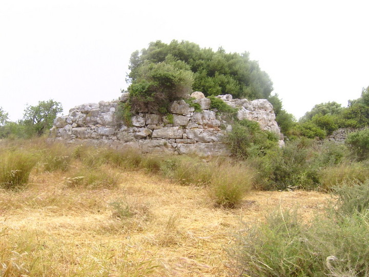
Browsing the Balaerics again ...Last May, Beardy and I had thoroughly enjoyed exploring Menorca and its talaiotic remains, so the renewal of annual leave entitlements, a lack of cheap fags, and the desire for some sun, lead us to head to Mallorca at the end of April. A couple of days were spent relaxing in the city centre in Palma, but then it was time to pick up the hire car, have the usual screaming rows about how to get out of the mad city traffic and onto the correct road, but eventually we checked into our hotel on the east coast of the island and almost immediately headed out in search of the local sites. Less than 5 km down the road, that being the main road from Son Servera to Porto Christo, the (left) turn to Sa Coma also had a pink archaeological sign to the Talaiot de Na Pol. We pulled in just past the police station, and when I checked the rear view mirror, there, on a corner lot, was the circular talaiot.  It was built over a natural cave - here's Beardy climbing out  which appears to have had much rubble and rubbish tipped into it.  I can't remember if there was an information board about the site - legible ones are few and far between, we were to discover later - but the place felt unloved and ignored, despite its signage from the road. The gathering clouds started to chuck rain down with some force, so we retreated to the car and set of to find the Poblat Talaiotic de S'Illot - via the scenic route through the resort, with the rain worsening every second, visibility down to almost nil, and with the roads rapidly flooding. It was actually only a couple of km further south, and again signposted from the main road - but we found it eventually squashed in with hotels and holiday homes on 3 sides.  The most prominent feature is the external wall  Yes - quite wet! There are numerous rooms and enclosures around a central monument but it's hard to distinguish what's what in the ruins.  The information board had been trashed, and the continuing downpour led us to beat a relatively hasty retreat to the novelty of a free bar .... Sat April 29th Ah. That'll be a hangover then. Remember, free tequila always hurts more than the stuff you pay for! The plans to explore the north east of the island were put on hold to allow recovery and eventually the rain stopped, so we headed out. South again - this time off the main road from Porto Christo to Porto Colom. Just past a zoo, there's a left turn to Cales de Mallorca - also with the pink sign to Hospitalet Vell. The first site that was clearly marked on our (AA) map as "ruinas prehistoricas"! Only about 1km down the road, you can see what appears to be a huge wall to the right a way off the road, and soon after there's another sign and a layby in front of a gate where we parked up and walked up the track to the poblat. Before you actually get to the wall you've seen, a signpost directs you to the left to the foundations of 3 naviforms with a small wood still separating you from the major part of the site.  Back round the wood and the sheer scale of what appeared to be a wall reveals itself as a rectangular monument  with the huge blocks of stone typical of the building style of the era. The interior of this monument had inner walls added later.  Exploring round the back, a path leads to the left to a square talaiot with a series of rooms around it  and wooden steps to allow visitors to admire the central support pillar of the talaiot and the only known remaining spars which formed the ceiling and second floor - the last century hasn't been kind to the momuments on the island and many have been left to go to ruin, if not ruined intentionally.  Beyond the talaiot and surrounding rooms, there's a heavily overgrown area with more ruins extending into the woods. With the sun shining, we decided to continue south to just beyond Porto Colom. We ignored the first road into the town, the PM 401, but took a more minor road to the left opposite a golf course. Our directions were based on coming from the town - the opposite route - but after about 2km we spotted some stones right on the edge of the road on the left  so parked up and went to explore. Almost all the site - called Es Closos de can Gaia - is in the process of being excavated, but at a very slow rate (20 days a year apparently) and almost all was covered with black tarp and spikes  and we could only make out only one naviform in the uncovered area and that was becoming overgrown  The site is on the road out of Porto Colom towards S'Horta - the road narrows as it leaves the urban area and the roadside stones - a naviform - are clearly visible on the right hand side. Feeling weary, and with sunset almost upon us, we headed back for a gentle evening in preparation for a full day of exploration. And that day's adventures will be coming soon .... |
5th May 2006ce Edited 8th May 2006ce |
April 2006 part 2 (Loughcrew) |
April 2006 part 2 (Loughcrew)April 13 We were searching for rock-art but we are complete amateurs. However, this was only a setback when we realised what we were missing by not having the key to cairn T. Exploring the site 'blind'ish (blindish because we had the book though we hadn't read all Cary Meehan had to say) was fun. Our first 'discovery' were the heavily decorated 2 stones on the left of the entrance to cairn T. We had found our spirals! The gate at the entrance blocked our ability to to get good shots as Oscar's camera wouldn't fit through the bars. Leaving the frustration behind we headed for Cairn V. There is a beautiful concentric circle carving at the base of one of the standing stones (kerbstones? orthostats? Have to work all this out yet). Having been inside Newgrange and been told that we couldn't photograph anything, we were now like the proverbial kids in a candy-shop. Róisín wandered off as we were photographing Cairn V. She'd gone to Cairn U and 'discovered' the decorated stones in the arms of the cross. Well done Róisín! The wind had really picked up at this stage and Oscar was freezing. I noticed the cold but didn't really feel it as I was busily snapping everything (digital cameras hooray). Also, I didn't want to leave the place, a sensation that I have since experienced at other sites that I've visited. There is so much to see and do on Carnbane East that a return visit with more time is a must. As we were leaving a local man showed up with 2 of his grand-children. They headed for the entrance to Cairn T but no-such-luck, they hadn't got the key. The views from this hill-top were stunning. Looking across to Carnbane West we could only wonder at what treasures it held. That's a story for another day… |
Posted by ryaner 4th May 2006ce |
April 2006 |
April 2006I've gotten into this through a friend of mine from the Canary Islands. There is some rock art on the island of La Palma and he wanted me to show him some of our Irish examples. He came to Ireland for 20 days at the beginning of April and so off we set. I had no experience of investigating ancient sites save for a school trip to Newgrange, a time before the visitor centre and the re-construction of the tomb. Where we went: Newgrange (not Knowth or Dowth), Crossmaglen and South Armagh, Belfast, the East and North Antrim coasts, the Giant's Causeway (had been here years before), Derry, Glenveagh Mountains, Errigal and the Devil's Glen in Donegal and back to Dublin. Where we went 2: Slieve Bloom mountains, Moher, Kinvara, Galway City, Inis Mór, Galway City and back to Dublin. At this stage I was getting a slight education in megalithics. We were using Sacred Ireland by Cary Meehan (Gothic Image Publications) on our travels and LoughCrew was calling. We headed there with my daughter and dog. I read that we needed to get the key to Cairn T on Carnbane East but gave up trying to find Loughcrew Gardens & Estate as I didn't know the extent of what I would be missing without the key. A word of advice: get the key!! The climb from the car-park is easy (well, easy in comparison to the climb to Seefin Hill Passage Tomb). The fenced in site on Carnbane East is stunning. It was an intermittently sunny and cloudy day with a strong wind the day we were there. Dún Dúchathair — Images04.05.06ce
|
Posted by ryaner 3rd May 2006ce |
Lundy Island, its place in our culture |
Lundy Island, its place in our cultureThe really great thing about Lundy history, is that whilst the (relatively) well documented post-norman periods are full of lively characters and colourful incident, there is so much more, as Lundy not only has a real place in Celtic and Arthurian myth, but also offers a range of interesting conundrums – the "what ifs". This, for me, is the really exciting thing, as it allows your own imagination to fill in the spaces around the frail fragments of historical record that do exist. It is known that Lundy had earlier names: Ynys Elen is oft quoted, and is worth remembering for later discussion. It is believed in certain quarters that this means, in the Welsh tongue, the Island of Elen, a Celtic saint. There is no other evidence that links the Island to her, but Lundy certainly had its own resident saint: Saint Nectan. It was pretty well established that the Old Cemetery, next to the Old Light on Beacon Hill, had existed since the early Christian period, but archaeological surveys have identified the central grave of Nectan (from the 5th Century). His bones were re-interred on the mainland at Hartland Abbey, where there was a shrine dedicated to him. The soil on the Island is acidic, and does not take good care of remains. However, the site of his original burial is recognisable. The four standing stones against the wall of the Old Cemetery (not their original locations) are perplexing, and many efforts have been made to define their original purpose. I favour the conjecture mentioned (although not necessarily supported) by Tony Langham, in the spring edition of the Lundy Island Chronicle, 1985, regarding the possibility of a link with St. Patrick. Two of the names engraved may refer to Potitus (Patrick's grandfather) and Restitutus (related through his sisters marriage). Certainly this is highly circumstantial. But the origin of the name "Lametry", the bay beneath the castle, has always been a mystery: yet the Bishop of Auxerre, whose name happened to be Amator, ordained Patrick. It is also quite likely he may have at least visited the Island: a natural staging post on his travels from the South West to Ireland. But let go of your logic for one moment, resort to your imagination for the final piece: there are no snakes on Lundy! But the spiritual dimension to the Island predated both Nectan and Patrick's time. In the Celtic world, Islands, particularly those on the west coast, were holy and powerful places almost by definition. Yet Lundy had special status: it was the island of "Annwyn", gateway to the otherworld and home to half human powerful beings: this is arguably still the case in the winter shutdown, when something happens to the islanders (what happens on the island, stays on the island!). The earthworks at the top of the cliffs on the Westside actually stretched up beneath the site of the lighthouse complex – and abutted the Old Cemetery. I would contend that it is unlikely these were dwellings, as the location is as uninhabitable and exposed as anywhere on the Island. Anne Westcott (a knowledgeable and committed Lundy Veteran) suggested to me that perhaps they were burial mounds, and certainly this would seem more appropriate. But there are so many; certainly more than would be required solely by Island inhabitants. Therefore, it is possible that the dead were actually brought to Lundy: perhaps important people (Kings and spiritual leaders?) . This seems quite possible, and the implication is that, combined with the Old Cemetery, Beacon Hill has been spiritually significant for something approaching 5000 years. This would be highly important. Lundy role as a bastion of Early Christianity, particularly of the Celtic strand has been well documented elsewhere, but this means the Island had an existing importance to the peoples on the mainland. It was the usual practice for the early Church to absorb traditions, mythologies and significant locations into its own teachings as it gained a cultural foothold in its growth. Lundy would have been no different. So, perhaps we can agree that Lundy was significant both spiritually and culturally for 5000 years: at least locally. Lundy is visible from the majority of South Wales and North Cornwall, the heartland of the Celtic peoples as we acknowledge it, and the Island was slap bang in the middle of that world. But was there any significance attached to the place in wider society, would the peoples "upcountry" be familiar with it? Unfortunately, there is unlikely to be any real hard evidence to confirm this, but Robin Heath has achieved a great deal of interesting work in his studies of Stonehenge. Heaths studies are very involved and highly technical: it is beyond the scope of this site to explain anything other than the possible conclusion. But his book – see Further Reading is absorbing and highly significant to the Islands possible role in Stone Age times. Stonehenge was built around 3000BC, yet why was it located where it is? Why not move it closer to the source of the Bluestone, used in some of the construction, which came from Prescelli in South Wales. (The use of Bluestone must have been considered essential to the constructors of the henge: the effort and organisation involved rule out any other explanation). Heath has discovered how the builders and designers of Stonehenge used its geometry to provide the calendar that underwrites its existence. Interestingly, the root of it is a Pythagorean Triangle. If you expand this triangle to run the hypotenuse from Stonehenge to Prescelli, then drop down the other two sides as proscribed by Pythagorean rule, the "elbow" of the triangle rests securely, indisputably on Lundy: on a small hillock just north of Pondsbury. Where, if one looks carefully, is a small, decayed stone circle. Perhaps this is just wild conjecture: but to refer back to the name Ynys Elen: an alternative meaning is derived from the welsh word Elen, as opposed to the name: it means elbow. ( A chill up the back is the correct response at this point). The implication is that Lundy was the reference point: Prescelli then became the source of the bluestone: in which case Stonehenge could only be built at its present location. It is an interesting and compelling conjecture; unlikely to be proven one way or the other, just another question of the many that make the Island the mystery it is today, just as it was thousands of years ago. Lundy Island: Peter Robsons Site — Links27.04.06ceA general site for Lundy, from the perspective of an islander. Majors on the history and mythology that surrounds the Island
|
 Posted by lundypete
21st April 2006ce |
Jelling |
Jelling8 April 2006 It was raining hard and looked set in for the day as we approached Jelling, Denmark's spiritual home. Moth and had I been musing on the difference between British jam and American jelly, wondering about the (il)logic of American musicians jamming rather than jelling, when, quite randomly, Bob Marley's 'Jammin'' started playing on the MP3 player. Jelling was virtually deserted when we arrived. Ours was the only car in the car park and everything was closed, even the museum. And it was very, very cold. Jelling is a small town centred on series of monuments from a number of different ages. First a bronze age barrow, then a Viking stone long ship, then runestones, then two gigantic mounds, then a church. Peel back the layers here and you begin to understand Denmark's history and sense of national identity.  Picture: taken from a photo in Jelling museum It is only 1,000 years since Christianity was adopted by Danish kings over the old religion and Jelling marks the place where this happened. Outside the church that now stands between the two mounds a Viking runestone is carved with the earliest known image of the crucified Jesus in Scandinavia.  Each monument has been acknowledged and built into the next phase of Jelling. I like that continuity even if it does mean the land close to the mounds around the church and the runestones is now filled with neat and tidy modern graves.  We wandered around trying to make sense of it but the place lacked atmosphere without any people around. Unusally this is set of monuments that needs people to make it live. A visit to the museum would help us understand but it wasn't open for an hour and a half, so we drove around in the rain in a fruitless search for the carved tree on the Jelling pages of TME before returning to Jelling Kro for some coffee and a plate of chips. The museum is situated directly opposite the mounds, runestones and church. As you go round reading the excellent displays in Danish and English you can glance out of huge glass windows and actually see the monuments in front of you.  There is a feel of Avebury about this place – the monuments and history still being occupied, enjoyed, revered and used, even if the reasons 'why here especially?' are not addressed. It is pretty remarkable that only a few years or so before William of Normandy invaded England, the Danes were still following their native 'pagan' religion. That's modern history as far as I'm concerned. As we waited for the boat to leave Esbjerg we killed an hour or so at Marbaek Strand where the sun came out, I was able to paint and we watched gulls and oystercatchers making their living on this glorious stretch of west-facing beach.  Photos: Moth Clark |
 Posted by Jane
15th April 2006ce Edited 16th April 2006ce |
Langeland: more lovelies |
Langeland: more lovelies7 April 2006 We were so wowed with Langeland that we felt another trip was necessary. I liked the close proximity of all the monuments and their variety (it's a bit like Carnac in that respect) and the delightful drumlin-hilly landscape. I was feeling quite miserable due to the terrible cold weather and long driving days we'd had. I felt sure that Langeland would cheer me, especially as the sky was blue and the sun was shining. Next time we're going somewhere hot – like Sardinia – Moth promised. (Or Africa, I hoped.) We started at Skovsgard megalithic longship tucked away in some leafless late winter woodland in the east on the island. The stones were all there, but all fallen down and thick with acid green carpet moss.  At one end the stone was bigger, like a prow. If only they could be re-erected, this'd be a corker. Just a five minute drive away (everything here is just a five minute drive away) the Kædeby dolmen lurks in a hedgerow to the south of Kædeby.  It's isn't that easy to find as there are no heritage signs to it and no information board. It's not until you're right up close do you realise the enormous bulk and height of the capstone. As we approached Moth disturbed a sleeping hare, and two deer on the path ahead of us didn't notice our approach until we got quite close.  There were some cupmarks on the capstone showing up clearly in the low sun, but I'm no rock art aficionado and was not whelmed.  The Annemolehøj jættestue is just across the road from the Dyssekammer i Herslov which we had noticed at the roadside the day before.  This was lovely. As usual, the information board displayed lots of useful text in Danish, but from what we could glean the usual potsherds, ritual axes and amber beads were found.  This passage grave had a wide transverse chamber which once you were inside it felt inconceiveable that such a large stone structure could be hidden under such an unassuming little mound. On a line within sight of the Dyssekammer I Herslov and the Annemolehøj jættestue is yet another monument, the Langdysser I Herslov, but it looked unkempt and had no visible access from the road.  Ringelshøj is a long barrow like Hulbjerg and is tucked away in trees. It was pretty unkempt, but at one time was yet another monster.  Moth noticed Pæregårdstrand dysser on a map and wanted me to see it because he knows how much I love beachside monuments. Pæregårdstrand dysser is about 1000ms along the beach perching on the sandy cliffs, 7 metres above the seashore.  Unfortunately it was overgrown, forgotten and largely trashed, despite its stunning location and the fact that it was once a large monument with three chambers and good sized kerbstones. The walk back along the deserted beach under virtually cloudless skies was wonderful.  I liked Kong Renes Høj a lot.  It's not hard to see why. We were particularly intrigued with the capstone of one of the dolmens which someone at some point had tried to cut into pieces. They failed to complete the job and left the chunk they'd removed where it lay.  We stopped briefly for Moth to see the very long Langdysser nord Forfrettesvig, but it was in crop and he couldn't get to it. Tvedeskov is fascinating. Tucked away in woods this double passage grave has lost all its caps but this gives the advantage of being able to see its design. A nice job was made when it was excavated and restored in 1978.  Our final monument on Langeland was the disappointingly abandoned and probably only just tolerated Jaettestue i Skovtofte. In a pine and birch plantation it reminded me of Slatepits Copse long barrow in Oxfordshire – almost lost, horribly overgrown, carpeted with thick moss and in danger of complete loss through sheer neglect.  So many monuments in such a tiny place! Either they escaped destruction because of Langeland's remoteness, or the population here were prolific in their grave building because the farming, fishing and fowling was so easy. The lack of Romans and the late arrival of Christianity probably helped, too. If you want to take your family on holiday and still see sh*tloads of big old rocks, you'll do no better than Langeland. Just make sure you go during the summer months.  Glossary Høj – hill or mound Jættestue – literally 'giant's stones' Skibssætning – megalithic longship Ringdysser – mound or barrow with stones or burial chamber Dyssekammer – dolmen or burial chamber, I think! Langdysser – long barrow with stones and/or burial chamber Photos: Moth Clark |
Posted by Jane 15th April 2006ce |
Langeland: will the real Kong Humbles Grav please stand up |
Langeland: will the real Kong Humbles Grav please stand up5 April 2006 In The Megalithic European, Julian pays little more than a double page spread of lip-service to the long, glorious island of Langeland off the southern coast of Fyn in Denmark, almost certainly due to lack of space in the book and time in the field. So I'm going to try to make up for that here and in my next blog (coming soon). The thing that doesn't come over in Julian's commentary is the sheer variety, intensity and close proximity of monument after monument in this small finger of land. It took us two days to do it justice. The bridges to get there are mercifully toll-free and the rolling countryside on the island is more enchanting even than the rest of Denmark. Langeland is home to scores of bird species and hares and deer abound. The main town on the island is Rudkøbing which felt very strongly like a far less bleak Kirkwall. It was Moth's birthday and while we were waiting for our friends Cloudhigh and Roland Wyckwyre to join us for some lunch, we quickly zipped out of town to see Bjerrebygaard dolmen.  We arrived in blazing sunshine and galloped over the muddy field to reach the stunning monument, cluster of large stones, dolmens with giant capstones and six monster, gnarled 'pantomime' oak trees sticking out of a large mound. Very dramatic.  We spent some time enjoying it until the sky in the northwest darkened suddenly and a wall of weather closed in. We made it back to the car just in time as a full-on blizzard of hailstones pelted down.  We thought we'd take Cloudhigh and Roland Wyckwyre out to see two monuments guaranteed to delight even non-stone-huggers: Kong Humbles Grav and Ristinge Klint, a dolmen near a beach. Kong Humbles Grav is in all the guidebooks as the most fabulous langdysser with exposed chambers in Langeland. So what we couldn't understand was the place that Julian's instructions took us to in TME…  …a most underwhelming, crescent shaped long embankment on top of a huge grassy mound overlooking the town of Humble, opposite the church.  Moth and I couldn't believe it. We were embarrassed to have taken our friends after the major build-up we'd given it. Something was wrong. We left disappointed and highly suspicious. As I drove us to our next monument, Moth checked other guidebooks, including the Oldtidsminder På Langeland by Jens Bech of Langelands Museum and Jens Kortermann, a jewel among guidebooks (text all in Danish) but with brilliant maps and drawings. Oops Julian! If you're reading this, I'm afraid you screwed up, sweetie. The underwhelming earthwork you call Kong Humbles Grav on page 168 of TME is no such thing. The real Kong Humbles Grav will stand up in two paragraphs' time. Meanwhile come with us to the dolmen on Ristinge Klint, on a tiny, narrow peninsula, jutting out the west of Langeland. The rain, hail and sleet had passed and the beach was bathed in warm sunshine, the first time I'd not been cold whilst outside all week. We walked along the path up through the dunes and along the sandy cliffs above the deserted and beautiful beach until we reached this glorious erection:  It was much bigger than we dared hope from the tiny line drawing in the pamphlet we had. We were all delighted with it.  The *REAL* Kong Humbles Grav We returned to where we'd previous been to see Kong Humbles Grav and found the real one with not too much trouble. Here's how to get there. Drive past the church and turn down the first farm track to the left, towards a beautifully kept pink and blue farm house with a monster yellow barn. Park here, put your money in the honesty box and walk north behind the white barn and follow the track through the field. Here is Kong Humbles Grav – a magnificent long barrow with squared off ends and lots of good kerbstones.  The main chamber in the middle is an exposed dolmen in superb condition.  Straw had been put on the ground in the chamber so I shot in, not only to get out of the bitter wind and the threat of rain but because it really was delightfully hygge in there! Our friends departed and we pressed on towards Hulbjerg jaettestue from where I was thrilled to see a honey buzzard.  Hulbjerg is a classic little passage grave, with a good puffy domed mound and a transverse chamber coming off a narrow and low short passageway.  Beautifully restored and carefully tended, this is a model of care for our prehistoric past. From here we drove to Myrebjerg jaettestue, past some wetlands and lakes crawling with tufted ducks, but the field was in crop and we couldn't get to it. The Ormstrup langdysser looked promising and spectacular…  … but again the field was in crop and this no-entry sign made the situation pretty clear.  The Kindeballe dolmen was just round the corner from Ormstrup and a great surprise to see at the roadside.  Hesselbjerg langdysser is featured on page 168 of TME in an open watery landscape alive with swans and geese. Compared to other langdyssers we'd seen I found this one disappointing but Moth loved it.  I'd had enough at this point but Moth nipped out quickly to see Langdysser ved Ristinge Nor:  As we drove back towards the bridge to get us back to Fyn, we spotted this Dyssekammer i Herslev from the main road, the 305.  Ain't that sweet? Glossary Høj – hill or mound Jættestue – literally 'giant's stones' Skibssætning – megalithic longship Ringdysser – mound or barrow with stones or burial chamber Dyssekammer – dolmen or burial chamber, I think! Langdysser – long barrow with stones and/or burial chamber Photos: Moth Clark |
Posted by Jane 14th April 2006ce Edited 17th April 2006ce |
Katbjerg and the Spanskhøj mystery solved |
Katbjerg and the Spanskhøj mystery solved4 April 2006 … …continued from previous blog … We pressed on northwards towards the charming cobbled-paved town of Mariager where Hohøj, the largest mound in Scandinavia is found.  It is situated at the highest point hereabouts and from the top of its 12metre high bulk there are glorious views. Silbury it ain't, but it is impressive anyway. Legend has it that it was once inhabited by a pig-scoffing troll. Don't miss the Katbjerg monuments On route 555 out of Mariager, Moth had found our next set of monuments on the internet. We could find no printed information about the monuments at Katbjerg at all which is almost criminal, because the long barrow called Kongehøjen ved Voldstedlund is the finest long barrow we had ever seen. , Yes, seriously!  This monument was untrashed and probably not much restored. It was long – perhaps 25 metres and rectangular with a continuous line of big kerbstones. And tall, too! The mound billowed upwards along the entire length of the monument, completely undenuded.  No fancy horned forecourts here though; instead just really whopping stones at each end. Down one side are two low passageways, each leading to a large intact chamber. Oooh! Oooh! OOOOH! This place blew our minds.  Fifty metres directly west is the ruins of a round barrow which has lost much of its material but still has a chamber to see.  Now badly overgrown and rather unkempt, this is home a families of blue tits. Continuing west on the 555 you don't need your specs on to notice the Jordhøj and Ormhøj barrows, sited on the same east-west line as Kongehøjen ved Voldstedlund long barrow  These are gigantic! We didn't bother to walk over to them as the clouds threatened to do something evil again, there was nowhere to park at the roadside and no obvious track through the field to get to these huge barrows, with their south east facing entrances. Yikes! Julian gets it wrong It was late in the day and I was døgntired after already having driven more than 170 miles north. We still had 115 miles to get back to our cottage, but we couldn't miss what Julian calls Spanskhøj on page 159 of TME. After reaching Snæbum* we saw the sign to drive into a farm courtyard. Before we had even turned the engine off, a kind woman had scurried out with a huge torch for us to view inside the mound. We dropped our 6kr kroner each in the honesty box, took an informative homemade leaflet and set off through the thick smell of pig poo to the field with the mounds. *yes, we tittered, too! Spanskhøj, Snibhøj and one other flattened double-entranced mound stand in the same field. But don't be mistaken, as Julian apparently was. The picture in TME is not of Spanskhøj it is Snibhøj. Both the information leaflet we picked up on site and James Dyer are clear about this. Snibhøj is very special.  I'd never seen a monument like it…  … two passageways, two fabulous chambers one of which housed this tiny, sleepy bat.  Immediately next to Snibhøj this is all that is left of its once identical neighbour. We couldn't find its name.  Spanskhøj stands tall and proud at the other side of the field. We drove round to see if we could get in. We couldn't. It was quite tousled with vegetation and had no clear path to it. It certainly had two passages but there was no way we could get in.  Well, now you know for your next edition, Julian, if you're reading this. Glossary Høj – hill or mound Jættestue – literally 'giant's stones' Skibssætning – megalithic longship Ringdysser – mound or barrow with stones or burial chamber Dyssekammer – dolmen or burial chamber, I think! Langdysser – long barrow with stones and/or burial chamber Photos: Moth Clark and Jane Tomlinson |
Posted by Jane 13th April 2006ce |
Møls and Tustrup |
Møls and Tustrup4 April 2006 From where we were staying on Fyn, the monuments of north east Jutland, Denmark seemed quite long way for a day trip. Nevertheless we went. Our first stop was Groenhøj (page 163 of The Megalithic European [TME]) chambered tomb, near Horsens, a perfect pincushion of a monument, not unlike the Great Cairn on Porth Hellick Down, Scilly, but bigger.  It has a continuous ring of handsome kerbstones and a good high grassy mound. Like so many of the monuments in Denmark, the stones are lovely sparkly pink and grey. It has a very narrow corridor which I probably could have wriggled through to reach the chamber but as it was wet underhoof and I was wearing my only clean pair of jeans so I didn't bother. At its 1940 excavation, thousands of pottery sherds were unearthed here, the breaking of which was some kind of ritual associated with the use of the mound.  Today, under blue skies with big fluffy clouds and chaffinches darting around in the trees Groenhøj looked very hygge. From Groenhøj, we headed up to Møls area (page 160 of TME) on the beautiful Djursland peninsula, just north west of Århus. Its pretty remote up here, but quite gorgeous. The most beautiful part of Denmark I had yet seen. I wanted to see Poskær Stenhus – surely the most picturesque place in TME!  As we arrived the sun came out unbroken and I scampered about the monument like a happy bunny. Moth climbed the Tinghulen to get some height some photos and I , after speaking to a woman tending her horses (who, with the horse she currently tended had once lived in Lambourn) sat and found the view where the light was just right for me to paint.  Poskær Stenhus is essentially the skeleton of a monument exactly like Groenhøj – gorgeous pink kerbstones, bit of a passage, nice chamber complete with capstone, bob's yer uncle. But the setting here is so very fabbie.  Rolling fields and hills, great views, green pasture, heathy bits – oooh! And the nicest thing it's that somehow its all on a human scale. Nothing here is grand or majestic or mighty. It's all rather comfortable and nice. I like that.  It should be noted that at Poskær Stenhus visitors will find excellent toilets, so for once, ladies, you don't need to pee in the open and risk mooning as passers-by. Here's what I managed to sketch before I had to use the facilities:  The woman with the horse advised me and Moth to go up the road to the village of Agri where there was more stuff to see and very good walking. I didn't like to tell her that walking + me = no no, but we had a tootle up there anyway. How glad I was we did! As we drove up the hill I spotted this!  And this, one of the many Stabelhøje dolmens…  And many, many more! A note about Danish barrows There are tons and tons and tons of them! Everywhere! They are not the sad, flat remnants of once-mighty burial places we get in the UK. Oh no. Here in Denmark they are everywhere and stand tall and proud and big and round dotted all around the countryside with a gratifying frequency and seem to be a source of national pride. How sad that in the UK modern farming methods and treasure hunters over the years have rendered ours so deflated and scrubby. Anyway, the landscape of Møls is particularly rich in barrows. From Agri we headed off through the lanes towards the Tustrup jættestue. At one point I mis-navigated but managed to pick up an alternative route. I'm glad that I made this error or we would not have driven past this little dolmen, just sitting in a field quietly minding its own business.  Suddenly the weather changed! From bright sunshine we hit hail, then sleet, then snow, then more hail. Fortunately in the space of 20 minutes the blizzard passed and we were back in bright sunshine for the Tustrup jættestue (page 161 of TME) The place reminded us a lot of St Just in France. The heathland landscape, the birds, the general atmosphere. There are four main monuments here each within a few metres of each other. There is a stone chamber…  …this lovely chambered tomb with spectacular kerbstones…  … and a weird thing that was probably a building or mortuary house…  …and this marvellous passage grave.  It didn't have kerbstones but the interior was awesome! I sat on top of it for while and considered the landscape, the hooded crows and these lovely monuments. More from our day out in North East Denmark in the next blog… Glossary Høj – hill or mound Jættestue – literally 'giant's stones' Skibssætning – megalithic longship Ringdysser – mound or barrow with stones or burial chamber Dyssekammer – dolmen or burial chamber, I think! Langdysser – long barrow with stones and/or burial chamber Photos: Moth Clark and Jane Tomlinson |
Posted by Jane 13th April 2006ce |
Als well that ends at Baronens Høj |
Als well that ends at Baronens HøjAls is a small island off the south eastern coast of Jutland, Denmark, linked to the mainland by a toll-free bridge. It's got a few pretty HOT monuments...  Blommeskobbel (page 155 of TME) is tucked away in woodland off a muddy track – which thankfully you can drive to because it was raining again.  The trees gave some shelter but it was as damp and muddy and joyless as you could ever want. Blommeskobbel cheered me though. How could it not? The site consists of two langdyssers and two round barrows, with good kerbing, nicely exposed chambers and lots of character.  I had looked forward to Blommeskobbel not just because the name sounds so cool and it means flower stones in Danish, but because when I first saw page 155 of Julian's 'The Megalithic European' [TME] I knew it wouldn't be long before I would have get to Denmark. I would have liked to have painted here but it was too grey, too damp, too miserable. The weather was forecast to dry up later, but there was no sign of that as we headed up the coast a tiny bit from Blommeskobbel towards Nørreskov, 5 kms away. The Nørreskov monuments We'd spotted Nørreskov in James Dyer's book 'Discovering the Archaeology of Denmark' and as we were so close thought we'd take a look even if we hade already found Dyer to be slightly unreliable, banging on about finds and stuff rather than the monuments. (It's always bloody pottery sherds and amber beads, too.) Our first Nørreskov monument was at Frydendal Kro in the strip of woodland leading down to the sea. Here we found a rather cute little dolmen emerging out of a round barrow…  …. and right next to it, a short barrow (it wasn't long) with a good stone cist in the top.  Dyer suggested that there were others lurking in the woods like which went on for a few kilometres hugging the coast, like this one we just happened across…  The woods had some nice rough but driveable tracks running through it, one of which had a very promising name…  As it had suddenly stopped raining and it looked as if even the sun might appear, we drove along spotting birds (jays, an unidentified-but-mighty-raptor and a goldcrest!) and any suspicious humps with stones. We spotted a couple which were deeply underwhelming, but then rounded a corner and found ourselves face to face with the Havredyssers.  The road ran between them.  Each of them were great with plenty of high mound, kerbstones, cists and a chamber. Moth strode off into the woods to seek out the Gamle Troldhøj (the Old Troll's Hill) …  …while I sat in the car and had a cuppa like a miserable-and-fed-up-with-the-rain old cow. Three days of low cloud, brisk breezes and cold rain and had taken its toll on my mood. Dyer suggested another monument 5kms through the woods to look at. Despite feeling like 'I just wanna go home' we went to seek out what Dyer describes as: 'a fine round dolmen with a central burial chamber and a ring of kerbstones', the Baronens Høj. He should have just said: 'it's f*cking ace, Jane!'  The setting, the construction, the character and the fact that the sun came out while we were there lifted my heart! What a beautiful place. It perches like a little crown 25 feet above the sea in a clearing which it shares with an old farmhouse.  It reminded me of Innisidgen on Scilly which 'feels' the same. Its immediate neighbour, the old farmhouse was that very distinctive shade of Danish yellow and its thatch was thickly covered in moss. When the sun came out it glowed green and bright – it felt like it was the first time I'd seen Denmark in colour. That was it. Time to get the paints out. At bloody last!  This is what I managed to sketch.  On the way back to our cottage as we travelled through south Jutland, we sought out the Hjulgraven at an industrial estate at Hjordkær a picture of which Moth had found on the internet and looked very promising. In fact it was crap, so don't bother with it.  Badly restored barrows with not much more to see than concrete markers. Shame. Although the factory next door did have a very interesting collection of electricity-generating windmill parts. Glossary Høj – hill or mound Jættestue – literally 'giant's stones' Skibssætning – megalithic longship Ringdysser – mound or barrow with stones or burial chamber Dyssekammer – dolmen or burial chamber, I think! Langdysser – long barrow with stones and/or burial chamber Photos: Moth Clark and Jane Tomlinson |
Posted by Jane 11th April 2006ce Edited 12th April 2006ce |
Fyn finds |
Fyn findsFyn is the Danish island which lies directly east of Jutland and has a gently rolling landscape punctuated by neat little villages and farms of remarkable cuteness and character. It reminded me very much of Drenthe in the Netherlands, only not flat. Glavendrup Among this scene of bucolic charm is Glavendrup (featured in The Megalithic European [TME] page 156).  It's a bit like Klæbek Høje, that we saw the day before, in that it started as a Bronze Age barrow to which the Vikings added a whole bunch of girly pink stones. First a large runestone was mounted on top of the barrow, and they also built a skibssætning megalithic longship, of the same pink sparkly Barbara Cartland type stones, with stripes and waves of quartz running through.  The wooded area had also been added to by modern stones, inscribed with the names of 20th century archaeologists who worked here. They looked OK, but reminded me too much of the stone memorials in the woods at Bergen-Belsen to thrill me. The wind chilled me and there was no chance of sketching here. Magic at Marhøj At the north east tip of Fyn is a little promentary on which can be found Marhøj (TME page 158), a particularly thrilling giant barrow. In a landscape shared by other fat, high, humpy høj, Marhøj is Queen.  Wading through the dark earth of the field littered with flints, we reached the monument and found the entrance to the passageway leading in is half way up the mound, rather than at ground level. Stooping very low (if you're tall this is almost a hands-and-knees-job) I squeezed down the 5 metre passage flanked with big flat stones to reach the main chamber which runs perpendicular to it. The main passage was darker the dark. I got out the torch but it was unable to penetrate the blackness at all. I found a bit of candle and lit it. Then I found a tealight and lit that. And another and another and another until the whole chamber, 10ms long was illuminated by 26 tealights. It looked very hygge.  I sat down on the damp earth to inspect the chamber, smoke a cig and have a cuppa. It was vast: seven massive capstones formed the roof, all glistening in with wet in the candlelight making it as cosy as a fairy grotto. Moth scampered around with the tripod taking pictures and collecting more than 25 used tealights. It was cold in there – my breath was condensing - but it was out of the rain and the icy wind. It was fab. We headed south from Marhøj (there is no other direction you can go on Fyn) to the east side of the island to see Lindeskov which is only given a tiny entry on page 157 of TME. A complex at Lindeskov We'd spotted another thing in James Dyer around Lindeskov and sought it out first: Lindeskov langdysser at 168ms (yes, metres!) the longest barrow in Denmark, and certainly the longest I've ever seen. It was never more than a metre high or 5ms wide and had regular kerbstones, giving it a visual rhythm not dissimilar to a millipede. That sounds a bit wanky but it was really like that.  While Moth fluttered around with the camera, I inspected the handy visitors' information board. To my surprise and delight, it showed a map with another six monuments nearby. I looked up in the direction indicted on the board towards a dolmen which I could just see through a hedge. I made a mental note of the map and we set out in search of what turned out to be the Lindeskov Complex: for this was indeed a complex: a series of interconnected monuments, each with clear sightlines to the next and no more than 400ms away at maximum from each other.  I drove up a muddy farm track marked 'Privat Vej' but we went on anyway, as on the map I'd seen it clearly stated public access.  We passed the dolmen standing alone in the field in the same lonely manner as Devil's Den and left the car at the copse at the top of the track and set off into the woodland, first coming across a trashed barrow with a couple of capstones in the middle. Just beyond the trees in a clearing lay two mighty monsters, Lindeskov 2 and Lindeskov 3 a couple of twin sister langdyssers lying directly next to each other and about the same length and width. Each of them had good kerbstones. L2 had a single stone cist and L3 had three good exposed chambers with capstones – looking very like Schimeres at Emmen in Drenthe.  Just 20 ms from the top end of L2 was L5 a rungdysse (round barrow) with kerbstones and an exposed central cist which would not have looked out of place in Scilly. We felt quite chuffed with our 'discoveries'. Finally we drove to Lindeskov as featured in TME, a langdysser right at the roadside.  It's a main road but as Denmark has so little traffic it didn't matter. The monument is correctly referred to as Lindeskov 6 and is dribblingly tasty. It's not particularly long, but has five chambers exposed on the top, four of which still have capstones. With its regular pink kerbstones and high, pointy supporting stones holding the capstones aloft it seems all dainty and floaty. Glossary Hygge - cosy Høj – hill or mound Jættestue – literally 'giant's stones' Skibssætning – megalithic longship Ringdysser – mound or barrow with stones or burial chamber Dyssekammer – dolmen or burial chamber, I think! Langdysser – long barrow with stones and/or burial chamber Photos: Moth Clark |
Posted by Jane 10th April 2006ce Edited 12th April 2006ce |
Wet west Jutland |
Wet west Jutland1 April 2006 Forty minutes after the boat docked at Esbjerg in Denmark, Moth and I were at our first Danish monument, the Jættestue ved Mejls in west Jutland. Spookily the MP3 player randomly selected a track from Julian's Rite 2, a favourite on our megalithing trips.  As we drove through the almost flat sandy landscape we kept spotting large, tall round barrows – not the flattened shadows of their former selves you get in the UK - these are big, fat and pert. Effectively the jættestue were two very large barrows, one of which had been opened up to reveal two small stone chambers inside, looking all the world like little dolmens. Very nice. The weather was evil – cold, windy, wet. Grim, in fact…which interestingly is the Danish word for ugly. I didn't know it yet, but I would have to get used to this… Further north, up the west coast of Jutland, we headed for Ølustrup to see what is billed as 'three long dolmens and a long barrow' in James Dyer's 1972 book Discovering Archaeology in Denmark. It was peeing with rain, visibility was very poor and the air hung heavy with the smell of pigshit from a nearby farm. One of the long barrows had some nice exposed chambers, but the site was not particularly whelming. We were pushed for time so headed off towards our cottage near Middelfart* in the island of Fyn. [*yes, we tittered everytime, too!] Directly en route was Klæbek Høje (featured in The Megalithic European [TME] page 164).  Also known as Bække, Klæbek Høje is a couple of huge verdant round barrows from the Bronze Age with a much later addition by the Vikings.  They constructed a skibssætning, a megalithic longship between the barrows. The stones at each end of the 'boat' were bigger, implying prows. We liked it a lot. Dyer's book said that the depressions of tracks running through the middle were the remnants of a prehistoric military road or trackway, but neither Moth nor me bought this idea. Just down the lane from Klæbek Høje stands the mighty Hamborggårdsten, an oath stone.  Hygge is a Danish characteristic meaning 'cosy' or the pursuit of cosiness and is very important to our Danish brothers and sisters. There is no higher compliment than to say to your host: 'what a hygge evening'. For novice hygge-pursuers, light a few candles and you get the idea. When we reached our cottage near Båring we found it was not at all hygge. Within a hour our friends arrived, we lit some tealights, put the kettle on and things got more hygge as the rain pelted down on the thatch. Nevertheless we were to become rather fed up with rain…. Glossary Høj – hill or mound Jættestue – literally 'giant's stones' Skibssætning – megalithic longship Ringdysser – mound or barrow with stones or burial chamber Dyssekammer – dolmen or burial chamber, I think! Langdysser – long barrow with stones and/or burial chamber Photos: Moth Clark |
Posted by Jane 9th April 2006ce |
Orkney sites in local newspapers 1911-5 additions |
Orkney sites in local newspapers 1911-5 additionsBackaskaill ?HY63NW 15 May 13th 1911 "The Orcadian" cist with only damp earth inside found Breckness HY20NW 6 February 22nd 1913 "The Orcadian" 2 skeletons found in low cliff before Bishop's Palace previous week, others found on various other occasions Burn of Kithuntlin HY32SW 24 November 2nd 1912 "The Orcadian" one-line burnt mound description Burrian, Rousay HY33SE 13 September 21st 1912 "The Orcadian" artificial island, remains of causeway 1' underwater with central break Cauldhame, Stromness July 3rd 1912 "The Orkney Herald" journeyman's box found in 3' of peat Eynhallow August 23rd 1911 "The Orcadian" two skeletons found 3' deep Grainshore, Kirkwall March 7th 1914 "The Orcadian" cist eroded from shoreline by recent high tides Loch of Clumly broch HY21NE 1 September 30th 1911 "The Orcadian" described, was excavated by R.S.Clouston Loch of Kirbister HY30NE 6 September 21st 1912 "The Orcadian" holms probably natural, tradition of robber's house on Groundwater Island, possible gravestone there Lochside HY31SW 32 August 14th "The Orcadian" [not 13th] long cist with two skeletons and kerb found previously Maes Howe HY31SW 1 May 27th 1911 "The Orcadian" roof repaired and moat boundary fence erected January 11th 1913 "The Orcadian" description and work due Maeshowe Cist HY31SW 26 August 14th "The Orcadian" [not 13th] 5' x 4'6" x 2'9" rock-cut cist with burnt remains, no mound, found in quarrying 5 chains from Maeshowe "circle-mound" Maeshowe mounds HY31SW 21 August 14th "The Orcadian" [not 13th] cists found previous to HY31SW 26 contrasted as regards elevation Moss of Quothlan, Sandwick January 18th 1912 "The Orcadian" bow found 6' below surface St.Mary's Kirk, Biggings December 23rd 1911 "The Orcadian" described St.Peter's Kirk HY21NW 26 December 23rd 1911 "The Orcadian" St.Ninian's Well mentioned St.Tredwell's HY45SE 4 September 21st 1912 "The Orcadian" Chapel ruins on artificial island over ? Pict's house Skara Brae HY21NW 12 July 15th 1911 "The Orcadian" one-line description Stromness May 3rd 1911 "The Orkney Herald" short cist with flexed skeleton found during house construction in Firth's Park in Stromness The Warth, Flotta ~ND343927 March 15th 1914 "The Orkney Herald" worked grey stone (with possible mound remnant) SE of the Point of The Warth is called "The Sailor's Headstone" |
31st March 2006ce |