|
|

|
The Isle of Purbeck: Latest Posts |
The Harpstone (Standing Stone / Menhir) — Miscellaneous |
|
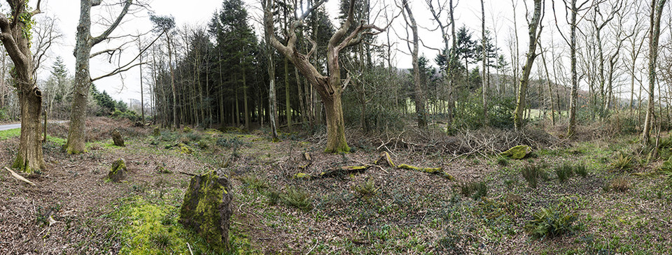
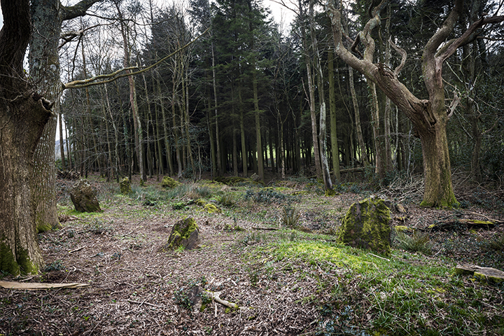
(27) The Harpstone (SY 98 SW; 92168058; Plate 217), monolith, of limestone, stands 1,180 yds. E.S.E. of St. Michael's Church, on the bank of a small stream and just inside the W. edge of Hurpston Coppice on ground falling gently N. to the Corfe River in the marshy valley bottom. It is 7¼ ft. high with a jagged and uneven top and has a maximum width of 3¾ ft. E.-W. and 3 ft. N.-S. The four faces are largely disfigured by vertical grooves and hollows, the result of weathering. Its origin is unknown. The place-name Herpston (1340) may refer to the stone, which stands on the bank between Herpston and Hyde manors and flanks the ancient road from Creech to Kimmeridge. (Hutchins I, 609; Fägersten, 136.) 'Stones', in An Inventory of the Historical Monuments in Dorset, Volume 2, South east (London, 1970), pp. 512-515. British History Online http://www.british-history.ac.uk/rchme/dorset/vol2/pp512-515 |
 Posted by Chance
29th March 2016ce |
Rempstone Stone Circle — Images (click to view fullsize) |
|
 Posted by A R Cane
23rd March 2016ce |
Flower's Barrow (Hillfort) — Images |
|
 Posted by juamei
6th January 2016ce |
Nine Barrows Down (Barrow / Cairn Cemetery) — Images |
|
Posted by juamei 22nd December 2015ce |
Povington Heath twin-barrow (Round Barrow(s)) — Miscellaneous |
|
Details of Twin-barrow on Pastscape (SY 88048412) Tumulus (NR) (1) A typical twin-barrow, both mounds being enclosed in an oval ditch. There is no berm except between the mounds. (2) A twin-barrow with surrounding oval ditch, and line of orientation NW-SE. The NW barrow has a diameter of 13.0 metres, with a height of 1.8 metres. The SE barrow has a diameter of 14.5 metres, with a height of 1.4 metres. No surrounding berms. The berm between the mounds is 0.9 metres high, and 1.5 metres wide at its narrowest point. The surrounding ditch averages 1.7 metres in width and 0.4 metres in depth. Both mounds and ditch are heather and bracken covered, and there are no signs of excavation. (3) SY 88048412. Ditched double bowl barrow of oval shape with two crests in profile. The length is 105ft. north west - south east, 69ft. and 62ft. wide beneath crests and respectively 6ft. and 7 1/2ft. high.The ditch, about 10ft. wide, surrounds the whole. (4) SY 880841. Round barrow on Povington Heath. Scheduled. (5) A twin barrow as measured and described by Authority (3), the ditch being slightly waisted between the barrows (see illustration card). Surveyed at 1:2500 on M.S.D. (6) |
Posted by Chance 23rd August 2015ce |
Warehan Logboat — Miscellaneous |
|
Details of logboat on Pastscape "The remains of a large canoe or barge hollowed out from the trunk of an entire tree", which Brannon informs us was found, with other naval remains, in the bed of the River Frome between Wareham and Stoborough. (1) (SY9286. Boat sited from auth 1 and OS 2500 1969 to the area between Wareham and Stoborough.) (2) |
Posted by Chance 23rd August 2015ce |
Cold Barrow (Round Barrow(s)) — Miscellaneous |
|
Details of Barrow on Pastscape (Name centred SY 904949) Cold Barrow (NAT) (1) (SY 90479505) A mound, situated on the highest point of a prominent knoll shown as a 200ft. contour on OS maps and at its northern tip. The mound is roughly circular 21ft. in diameter, 2ft. high and 9ft. across its flat top. (2) The natural knoll probably gave rise to the name Cold Barrow, which is now densely covered by a fir plantation which could not be penetrated. Several natural mounds in the area, typical of the local geology, have a barrow like appearance, and the mound described in authority 2 may possibly fall into the same category. (3) SY 90479505. 'Cold Barrow', bowl (?) barrow. (dimensions as given by Authy.2). (4) SY 90459503. Cold Barrow (name not confirmed), a mound as described (2), possibly a small barrow. In conifer plantation. Surveyed at 1:2500 on M.S.D. (5) |
Posted by Chance 23rd August 2015ce |
The White Barrow (Round Barrow(s)) — Miscellaneous |
|
Details of Barrow on Pastscape A bowl barrow with a mound composed of earth, flint and chalk, with maximum dimensions of 28m in diameter and c0.5m in height. The mound is surrouded by an infilled ditch. The size of the barrow has been reduced by ploughing. (SY 91029665. White Barrow (a); bowl (?) on fairly level arable about 140 ft above O.D. Only a broad irregular rise about 2 1/2ft high remains, suggesting former larger mound. (2-3) SY 91019664. 'White Barrow' (name not confirmed, not in local use), a barrow in arable, approximately 30.0 metres in diameter and 1.0 metres high. There is no visible ditch. Resurveyed at 1:2500 on M.S.D. (4) |
Posted by Chance 23rd August 2015ce |
Row Barrow (Round Barrow(s)) — Miscellaneous |
|
SY 9895 8030Details of Barrow on Pastscape Barrow depicted on a map of 1775, at which the court leet met, and after which the Hundred of Row Barrow takes its name. SY 98958030. The Row Barrow Hundred was named after this barrow at which the court leet was held. Hutchins mentions it, but its location only became known recently from a map of 1775. (1) |
Posted by Chance 23rd August 2015ce |