  
|
The info on this webpage comes from
"Two days in Cornwall with the Cambrian Archæological Association - 1862"
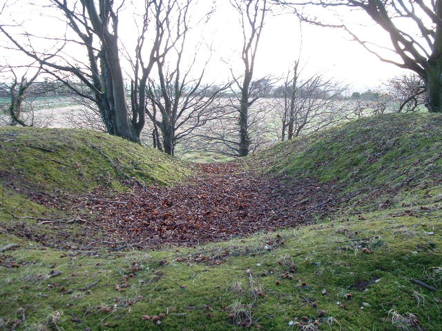
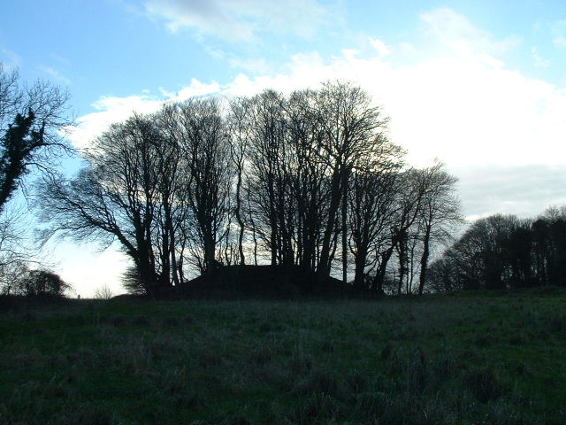
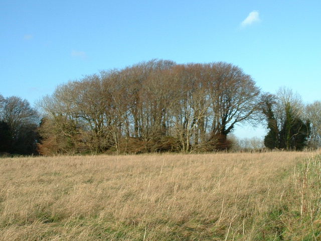
there are five diagrams of the beehive hut and some nearby sites.......
Fallen Cromlech, Bosphrennis
Plan of Hut, Bosullow
Plan of Chûn Castle
Chûn Cromlech
Mên-an-tol, Madron
Plan of St. Madron’s Well
This webpage is the work of Rick Parsons.
|
 
|
 
|
12 jan 2003
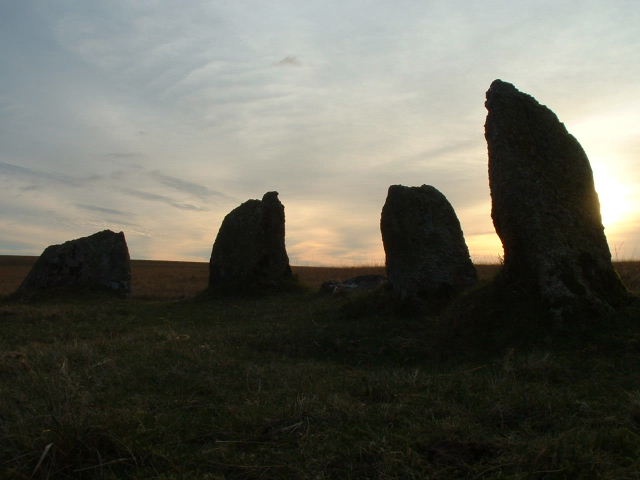
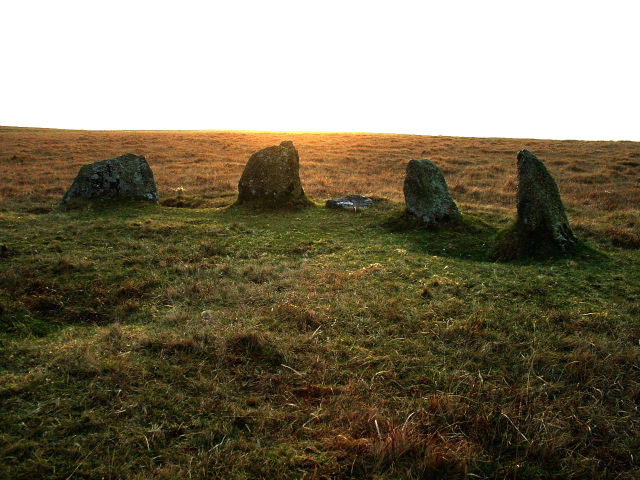
Took the route from stannon circle and thought that the Louden circle would appear before us as we reached the crest of the hill.....wrong!
The circle would easily be missed if wasn't for the map we had with us. There seems to be about 4 what you could call standing stones (stumps) and the rest are more or less stones on the ground.
Had trouble tracing the shape also. Just to confuse things stones seem to stick out of the ground all over the place many are obviously cairns there are also some stone banks that aren't marked on OS maps. Unfortunately didnt have time to travel down to Fernacre which would have been an circle within easy reach if we had time (maybe another day)
|
King Arthur planning to return to Tintagel
King Arthur is planning a dramatic return to his native North Cornwall next year - by standing for election to the newly-established Camelot ward of the district council!
Members of the council decided to name the ward, which includes Michaelstow, St Teath and Tintagel, "Camelot" after a review of boundaries completed earlier this year.
Now Arthur Pendragon (right), the self-styled King of the Britons, from Farnborough in Hants, has announced that he is considering standing as one of the two councillors who will represent the new ward.
"I'd love to become King of Camelot again," he said. "It's something I'm certainly considering."
The former Hell's Angel, soldier and gardener who changed his name by Deed Poll, is under no illusions about returning to his former glories at the Round Table.
"I don't imagine that any of the councillors are called Lancelot or Galahad, but it's worth fighting for anyway!"
He added that if he was elected and managed to become the council's leader he would think about moving the council's headquarters to Tintagel.
Annie Moore, spokesman for NCDC, said the council welcomed anything which raised the profile of local government elections.
"Obviously Mr Pendragon will have to meet the residency criteria to stand as a local councillor," she said.
|
Rillaton cup named as one of Britain's top ten treasures.
A 3,000 year-old gold cup found on Bodmin Moor - and once used by King George V as a handy pot for his collar studs - has been named as one of Britain's top ten treasures.
The Bronze Age Rillaton cup was discovered by workmen in 1837 in a burial cairn near Minions.
Searching for stone they stumbled across a vault, or cist, in which they found human remains, the gold cup, a sword, dagger and glass beads.
Such was the importance of the find that experts at the British Museum have now classified it as the 10th most important historical find ever made.
Jacky Nowakowski, a senior archaeologist with the Cornwall Archaeological Unit, said: "The Rillaton Cup is very important because it is a unique object and since the discovery of the Ringlemere Cup in Kent just over a year ago, interest has been renewed in it.
After the workmen's surprise discovery the artefacts were sent as Duchy treasure trove to William IV, who reigned from 1831 to 1837.
Despite their significance, they then fell into obscurity among the royal possessions, only to be picked out by King George V in the early 20th century as a handy container for his collar-studs.
It remained in that service until shortly after the King's death, at which point its true identity and importance were re-established and it was placed in the British Museum.
Little is known about how the round-bottomed cup, which stands just 8cms high, was buried or where the gold was mined.
But what is clear is that the valuable item was interred with someone of great wealth and power.
Jacky said: "It was a great period of monument building, the early stages of Stone Henge were constructed in the Bronze Age and a lot of investment was made in building large barrows, stone circles and henges.
"In Cornwall, exactly the same thing was going on and people were using these monuments to make a statement about their position."
Over the next three months the Ringlemere Cup is on temporary display alongside the Rillaton Cup while the British Museum raises funds to acquire it.
Source: www.thisiscornwall.co.uk
|
Earliest House In Scotland Found
Earliest House In Scotland Found At Lafarge's Dunbar Cement Works Quarry.
Archaeologists undertaking advanced investigations for Lafarge Cement UK on the site of the next area of mineral reserves to be worked in the quarry to the north of its cement works at Dunbar, in East Lothian have uncovered evidence of possibly one of the earliest 'houses' in Scotland.
John Gooder, senior project officer with AOC Archaeology Group, has managed the project. He said:
"What we have unearthed here is evidence of a Mesolithic family of hunter-gatherers who roamed the Scottish landscape between 8,000 and 4,000 BC. It's a very exciting find. Structures of this period are extremely rare, and there are only a handful of comparable examples in the British Isles and this is the only example so far found in Scotland.
http://www.construction-uk.co.uk/con_news.taf?_function=detail&_record=128567&_UserReference=616F070F40F5CC03C1C6A53B&_start=1
|
Preserving Pitt Rivers' Bronze Age Pots in Wiltshire
A major conservation project by Wiltshire County Council and two Wiltshire museums to preserve over 100 Bronze Age pots has reached the halfway point.
More than a hundred pots were discovered near Stonehenge, Avebury and other historical sites across Wiltshire by the Victorian archaeology pioneers, Sir Richard Colt Hoare, William Cunnington and General Augustus Henry Lane-Fox Pitt Rivers.
More with pictures at....
http://www.24hourmuseum.org.uk/nwh/ART14495.html
|
Branksome Stone Saved
http://www.poole-libdem.fsnet.co.uk/Wards/Bourne_Valley/bourne_valley.htm
One of the worries about the move of Branksome Library was the future of the Branksome Stone. The Branksome Stone is a neolithic relic that has been housed in the grounds of the library for a number of years and is the oldest known item in the history of Poole. Thanks to concerned residents, Poole Council and the East Dorset Housing Association, the new owners of the site, this important artefact from the past will remain available to the people of Poole.
|
Ian West's site has a great photo showing the stone before it toppled.
(No wonder it doesn't rock anymore!)
|
  
|
The many strips of cloth (or "clouties") which adorn the trees here. This tradition is still quite common in Britain as it is in many other parts of the world. The idea being to tear a piece of cloth from the part of the body which is ill, and as the cloth rots on the tree so the hurt disappears with it.
A few years ago there was great consternation in the local pagan community when unidentified persons took offence at the "heathen" practice and cut down the branches to which the clouties were tied. An act showing great disrespect for the beliefs of those who left offerings. On the other hand, however, some people miss the point and leave all sorts of things - plastic bags, crisp packets, foil wrappers - which can be an eyesore.
|
http://www.wdi.co.uk/air/coney.html
Coney’s Castle lies south-east of Lamberth’s Castle on the western edge of Dorset and has never been excavated.
Both hillforts lie on the boundary between the ancient tribes of the Durotriges, in Dorset, and the Dumnonii in Somerset.
|
This isolated and not widely known, well-preserved hillfort is situated on the summit of Dungeon Hill, north of Buckland Newton. It is surrounded by a single rampart and a ditch now overgrown with trees.
http://www.wdi.co.uk/air/a5.html
|
The defences of this hillfort consists of a single rampart and ditch on the northern end of a spur overlooking the river Stour.
The construction of the railway in 1857 uncovered a mass-grave of about 120 skeletons, probably the victims of the Roman invasion; part of a Roman shield was also found.
|
http://www.roman-britain.org/places/celtic/chalbury.htm
This pear-shaped fort is positioned atop a very steep hill dominating Weymouth Bay. Defenses consist of a single, 6m thick bank of rubble encased in drystone, and a flat-bottomed ditch with a simple entrance gap on the south-east. The hillfort defences were started sometime during the 5th century BC. Over 70 hut circles and numerous storage pits have been traced in the interior, and excavations at the site revealed a scatter of disarticulated human remains, which indicates exposure of the dead. The fort was very-likely the scene of - ultimately futile - resistance to the Roman advance through the area; this was presumably when occupation of the fort ended. There are many barrows and tumuli in the neighbourhood, including 2 Bronze Age round barrows at the centre of the fort itself, one of which contained a cremation burial.
|
http://www.geocities.com/Heartland/Woods/6322/History/binluldor.htm
Bindon Hill is on the coast near West Lulworth, Dorset, England. It is in the section marked "Danger Area" in the bottom left hand corner of the map.
Lulworth Cove is just to the left of the "DangerArea" This danger area is part of the Army - Tank Fireing Range on Bindon Range.
You can take the Bindon Road - which is a private road but also a public path to Bindon Hill and beyond. The earthworks that can be seen are the ditch and formerly palisaded rampart of the Bindon Hill. Bindon Hill is about 380 feet high and has a beach-head which had one of the first waves of Iron Age immigrants from the continent, in about 500 BC.
|
Weatherby Castle as it is called locally, has an obelisk at its summit ( 101m above sea level ), It is very well hidden, on top of a hill near Milbourne St Andrew. The area was originally a hill fort as can be seen by the ditches that still surround the summit.
Slightly more info and a picture of the obelisk can be seen at....
http://www.follytowers.com/weatherby.html
|
Stonehenge Tunnel Wins Instant Welcome From Archaeologists
http://news.scotsman.com/latest.cfm?id=5513829
Proposals to divert through a tunnel the busy road currently running alongside Stonehenge were today welcomed by archaeologists.
Archaeologist and broadcaster Julian Richards, who was at the World Heritage Site this afternoon to hear more about the plans, said today's announcement was extremely welcome news.
"This is a great step forward. We can put Stonehenge back into a more natural setting so people can appreciate what a wonderful site it is.
"You can stand here today and hear the traffic all around you – hopefully that will all change."
Chris Jones, leading the project for the Highways Agency, said it was a "historic day for the stones".
Environmental issues were a primary concern when considering the options and a bored tunnel would help to make sure the archaeology was undisturbed, he said.
"It is restoring the landscape to its particular historic context," he added.
Professor John Barrett, head of the department of archaeology and prehistory at Sheffield University, said the option chosen was better than alternatives of a tunnel cut from above or a highly expensive, longer bored tunnel.
"Stonehenge and its landscape allow us to encounter something of the mystery and power of the prehistoric world. This proposal opens the way for a far greater appreciation of that world," he added.
Arts minister Tessa Blackstone welcomed today's announcement, saying: "It will ensure Stonehenge is reunited with its surrounding monuments in their natural downland landscape setting, protect the site from heavy traffic and make possible the construction of a world class visitor centre."
Sir Neil Cossons, chairman of English Heritage which runs the site, said: "Today's news is a monumental moment in Stonehenge's 5,000 year history.
"It means that Stonehenge gets the dignified setting it so justly deserves, the roads are made safer and the core area of the World Heritage Site landscape is reunited."
English Heritage, the National Trust, the Highways Agency and local authorities are now expected to work on the tunnel's detailed design before publication of Draft Orders in the Spring
|
Mount Pleasant henge is one of the large Wessex henges and lies about a mile east of Dorchester. The bank was originally about four metres high surrounding an egg-shaped enclosure about 370 metres along its longer axis and about 320 metres along the shorter one. Originally the 4.8 hectare area could be accessed by four entrances. The bank is outside the ditch which had a diameter of about 43 metres with a single entrance.
more info at....
http://www.btinternet.com/~ron.wilcox/onlinetexts/onlinetexts-chap6.htm
|
|


