Images

Image of Offham Hill (Causewayed Enclosure) by Newell Fisher

The location of the small ditch I previously found and called Feature 12.

Its exact location, on What Three Words, is striving.remarking.ember.

I now think it lies on the bank of the north outer ditch, by Feature 6.

It is not directly related to the Causewayed Enclosure, but provides a useful reference point.

Image credit: lidarfinder.com
Image of Offham Hill (Causewayed Enclosure) by Newell Fisher

1975 aerial photo of Offham Hill Causewayed Enclosure and a fairly crude attempt to use AI to give a similar view of its early stages, let’s say around 3500 bce.

Image credit: University of Cambridge Air Photos and Dola AI
Image of Offham Hill (Causewayed Enclosure) by Newell Fisher

Overlay of image of the 1976 excavation over locations of World War 2 slit trenches, marked by purple diamonds.

Image credit: Mike Christie and thekeep.info
Image of Offham Hill (Causewayed Enclosure) by Newell Fisher

View North East from between Features 1 and 2. Lewes just visible on the right. Work on repairs after the 13th August Lewes derailment visible.

Image of Offham Hill (Causewayed Enclosure) by Newell Fisher

Location of southern entrance to the inner circle between Features 8 and 9 from the South. Centre of Enclosure visible.

Image of Offham Hill (Causewayed Enclosure) by Newell Fisher

Possible bank section of feature 6 from the path that follows the outer ditch of the same feature. Taken from the North East.

Image of Offham Hill (Causewayed Enclosure) by Newell Fisher

Southern end of path following feature 4 ditch from the South. Turn to North East visible.

This path seems to follow the course of the outer ditch of the outer bank from the western entrance to the Enclosure round to the north.

Image of Offham Hill (Causewayed Enclosure) by Newell Fisher

Feature lying on the north outer bank from the East.

Location on What Three Words: striving.remarking.ember

Image of Offham Hill (Causewayed Enclosure) by Newell Fisher

Feature lying on the north outer bank from the South.

Location on What Three Words: striving.remarking.ember

Image of Offham Hill (Causewayed Enclosure) by Newell Fisher

Feature lying on the north outer bank from the West.

Location on What Three Words: striving.remarking.ember

Image of Offham Hill (Causewayed Enclosure) by Newell Fisher

Feature lying on the north outer bank from the North.

Location on What Three Words: striving.remarking.ember

Image of Offham Hill (Causewayed Enclosure) by Newell Fisher

South West entrance of the Causewayed Enclosure around features 3, 4, 10 and 11. Looking North East.

Image of Offham Hill (Causewayed Enclosure) by Newell Fisher

Coombe Hill Causewayed Enclosure on the 1878 Ordance Survey map.

Sourced from maps.nls.uk

Image credit: Ordance Survey and the National Library of Scotland
Image of Offham Hill (Causewayed Enclosure) by Newell Fisher

An image showing the 1976 excavation of Offham Hill Causewayed Enclosure before most of the remains were ploughed out.

Image credit: Unknown
Image of Offham Hill (Causewayed Enclosure) by Newell Fisher

1975 aerial photo of Offham Hill Causewayed Enclosure.

Image credit: University of Cambridge Air Photos
Image of Offham Hill (Causewayed Enclosure) by Newell Fisher

1975 aerial photo of Offham Hill Causewayed Enclosure.

Image credit: University of Cambridge Air Photos
Image of Offham Hill (Causewayed Enclosure) by Newell Fisher

1975 aerial photo of Offham Hill Causewayed Enclosure.

Image credit: University of Cambridge Air Photos
Image of Offham Hill (Causewayed Enclosure) by Newell Fisher

1975 aerial photo of Offham Hill Causewayed Enclosure.

The whole area to the right of the reservoir enclosure is public access land now...but completely overgrown except for the path.

Image credit: University of Cambridge Air Photos
Image of Offham Hill (Causewayed Enclosure) by Newell Fisher

1975 aerial photo of Offham Hill Causewayed Enclosure.

Image credit: University of Cambridge Air Photos
Image of Offham Hill (Causewayed Enclosure) by Newell Fisher

An attempt to number the structures of the Enclosure, starting with the 1-4 numbering used by Mike Christie on Wikipedia, in his image.

I don’t know what those numbers refer to but it’s best to be consistent.

I am counting a “structure” as a defined feature according to the diagram, with an apparent ditch and bank pair counting as one structure.

Image credit: Ordnance Survey and Jumanei
Image of Offham Hill (Causewayed Enclosure) by Newell Fisher

An attempt to number the structures of the Enclosure, starting with the 1-4 numbering used by Mike Christie on Wikipedia.

I don’t know what those numbers refer to but it’s best to be consistent.

I am counting a “structure” as a defined feature according to the diagram, with an apparent ditch and bank pair counting as one structure.

Image credit: Ordnance Survey and Mike Christie on Wikipedia
Image of Offham Hill (Causewayed Enclosure) by Newell Fisher

This overlay of Mike Christie’s diagram makes more sense than the other one, as the established path passes between the structures of the Enclosure.

Image credit: Ordnance Survey and Mike Christie on Wikipedia
Image of Offham Hill (Causewayed Enclosure) by Newell Fisher

This is the archaeological map overlaid over the OS map.

The area is very overgrown but there may be visible remains on the paths that go though the Enclosure.

The problem with this version is that, in trying to scale the match to the two round barrows and the edge of the quarry, the established path ends up not passing between the structures of the Enclosure, which I have assumed it does. Field notes needed to confirm.

Image credit: Ordnance Survey and Juamei
Image of Offham Hill (Causewayed Enclosure) by juamei

Open Source Environment agency LIDAR

Image credit: © Environment Agency copyright and/or database right 2015.
Image of Offham Hill (Causewayed Enclosure) by danielspaniel

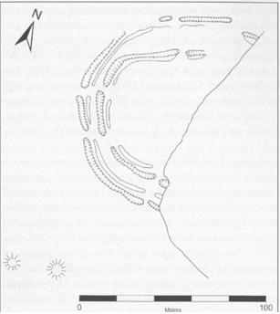
Plan of the enclosure as revealed by excavation and surface survey. The eastern part of the site has been removed by the quarry. The two barrows are shown to the SW.

Image credit: Redrawn from Drewett 1977

Articles

Walk around of feature previously identified as 12, starting from the North, then West, South and East.

Its exact location, on What Three Words, is striving.remarking.ember and, although not a part of the structure of the Causewayed Enclosure, it is a useful reference point, lying on what would have been the outer north bank of the Enclosure, which I have called Feature 6.

Offham Hill

I revisited this site on 15/9/26.

Having compared the feature I found to Lidar, I now believe it to be a distinct feature not directly related to the Causewayed Enclosure, but I have identified its exact location on What Three Words, which enables me to conclude that the path I previously said runs between the inner and outer banks, actually runs along the outer ditch of the outer bank.

I am relabelling the relevant pictures accordingly.

Offham Hill

Took a walk around the woods on Offham Hill today.

One of the paths goes straight through the remains of the Neolithic Causwayed Enclosure, much of which was destroyed by a Victorian chalkpit.

To the south are two Bronze Age round-barrows, which are often found near such Neolithic sites in this neck of the woods.

The area is heavily overgrown, but there may be traces of the Enclosure banks on the narrow paths that pass through the space.

Having overlaid the archaeological image of the Enclosure over the OS map, this definitely bears more investigation.

Offham Hill

One of the Sussex Neolithic Causewayed Enclosures, (others being The Trundle , Combe Hill and Whitehawk Camp)
Offham is much damaged by quarrying.

Ooops! Just updating these notes as last time I visited and posted I was looking at an 18th Century chalk pit, not a Neolithic Causewayed Enclosure!

The remains of the enclosure are actually up on top of the hill, just to the North of 3 bowl barrows (and, more prominently, a covered reservoir). The chalkpit has completely eaten the whole side of the hill, and taken the eastern half of the enclosure with it. Only a visit can make you appreciate just how much damage was done to the hill by chalk quarrying. One side of the site is a sheer quarry cliff.
What is left is a large C shape of ‘causewayed’ banks and ditches, the top half of which disappears into the woods on the northern slope.
However, this is all barely perceptible now, especially as the site appears to be returning to woodland quite rapidly. I scurried around like an idiot looking for something bank or ditch – like to photograph, but to no avail! You can just perceive some of the earthworks in the scrub, but it is nigh on impossible to trace any distinct circular pattern. Maybe better in the winter. Times like these you wish you could fly and get a bird’s eye view. (Although the multimap aerial photo doesn’t reveal much either)

Frustrated at the lack of obvious monument, I turn my attention to the setting: this is such a beautiful spot, and it’s location at the very edge of the Downs may have made it a special, boundary zone for early settlers. I know I will return again later in the season, and sit and feast on some of these wild strawberries that carpet much of this site.

Access: Park in Offham Village near the Church, cross the busy A275, over a stile and take the steep footpath up the side of the hill until you come out at the chalk pits. Look up to the escarpment on your right and you will appreciate how much of the hill has been taken out. Carry straight on into the woods on the other (south) side of the chalk pit and climb the path that curves round to the top of the hill. You pass another dizzyingly deep chalk pit on your left. Don’t get too close to the edge! Bear round to the right and you will see the fenced in reservoir atop the hill. The 3 bronze age bowl barrows are at the NE corner of the reservoir, and the enclosure is just to the NE of the barrows.

Link

Offham Hill
Causewayed Enclosure
Offham Hill Causewayed Enclosure. Walking along path that follows the outer ditch from North to West

Offham Hill Neolithic Causewayed Enclosure. The northen section that has mostly survived.

The video starts looking in the direction of the small ditch first identified as Feature 12, the northernmost feature of the inner circle.

It is actually a small ditch that lies on the outer north bank and is not part of the Causewayed Enclosure.

But its location on What Three Words is a useful reference point:
striving.remarking.ember.

The video then walks along the path that follows the outer ditch of Features 6 and 5 South West to the turn to the South.

The last section after the turn, if I am right, runs along the outer ditch of Feature 4, in the outer circle. It makes sense that a path like this would navigate such a ditch from a time when it was more prominent or the area was less wooded.

Sites within 20km of Offham Hill