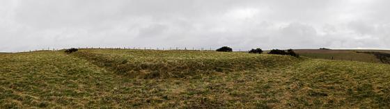
This ‘dyke’ cuts across the southern spur neck of Wolstonbury Hill, and this morning I find myself wondering where the main point of access was (if one originally existed) on this linear earthwork. Could it be at the central kink in the dyke, where a round barrow now sits on the Northern bank, or the area where the modern track bisects the bank? I walk down the ditch to where the dyke peters out and the slope gets steeper. The date of construction remains unknown. It could relate to a late Bronze Age/ Early Iron Age period of cultivation. Or, it could represent a ‘defensive outwork’ to the (speculative) period of defensive remodelling of Enclosure ‘C’ on top of the hill. As yet, nobody knows. I turn back and follow the ditch up to the ‘barrow’.
Articles
This linear earthwork appears to be one of the later prehistoric linear boundaries recorded from the southern chalklands. What exactly their purpose was has regularly defied interpretation. They have variously been referred to as; roads, defensive outworks, covered ways, barriers, toll bars or drove ways, ‘Celtic’ fields, ranch boundaries or pastoral enclosures. Even precise terminology is difficult. (I am using ‘Dyke’ on TMA for want of a better site type, but please do not take this as an implication of function.)
Sites within 20km of Wolstonbury Cross Ridge Dyke
-
Wolstonbury Platform Barrow
description 1 -
Wolstonbury Barrows
description 1 -

Wolstonbury Bowl Barrow
photo 9description 1 -

Wolstonbury
photo 22forum 3description 10link 2 -

Newtimber Hill
photo 2 -

North Hill
photo 2description 1 -

Devil’s Dyke (West Sussex)
photo 7forum 1description 6link 1 -

Tegdown Hill Barrows
photo 1description 1 -

Ditchling Beacon
photo 6description 2link 2 -

Fulking Hill
photo 1 -

Pudding Bag Wood Prehistoric Linear Boundary
photo 1description 1 -

Pudding Bag Wood Bowl Barrow
photo 2description 1 -
Bowl Barrow in Great Wood
-

Edburton Hill
photo 3 -
Cross dyke in Great Wood
-

Hollingbury Hillfort
photo 18description 4link 1 -
Brighton bypass Henge
description 1 -

The Goldstone
photo 10description 6link 2 -

Thundersbarrow Hill
photo 6description 1 -

Rest And Be Thankful
photo 3description 3 -

Plumpton Plain
photo 5 -

Whitehawk Camp
photo 7description 5link 2 -

The Steyning Stone
photo 3link 1 -
Castle Hill (Woodingdean)
photo 4description 1 -

Offham Hill
photo 6description 1link 1 -

Kingston Barrow Cemetery
photo 4description 1 -

Brack Mount
photo 3 -
Beacon Hill
description 1 -

The Tump, Lewes
photo 23forum 1description 3link 1 -

Steep Down
photo 4description 1 -

Cliffe Hill
photo 4description 1 -

Chanctonbury Ring
photo 32description 6link 2 -

Cissbury Ring
photo 27description 11link 2 -

Ranscombe Camp
photo 8description 2link 2 -

Saxon Down
photo 3 -

Mount Caburn
photo 23forum 1description 4link 2 -
Money Burgh
description 1 -

Church Hill Flint Mines
photo 3 -

Sullington Warren
photo 7description 1 -

Sullington Hill
photo 5 -
Peacehaven Heights
description 1 -

Blackpatch Flint Mines
photo 4description 1 -

Great Upon Little Rock Shelters
photo 17 -

Philpots Camp
photo 11description 3 -

Chantry Hill
photo 3