20/03/2016 – View to Wolstonbury
20/03/2016 – View to Wolstonbury

Across Wellcombe Bottom........


Looking approx north.......

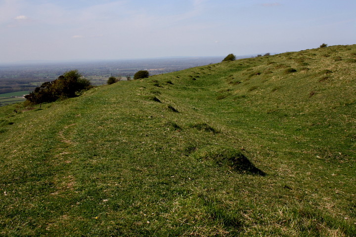
The best preserved section of the bank to north-east (ish)

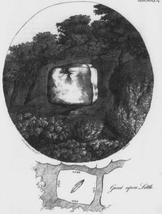
Spring upon Wolstonbury... if this was a hillfort, I’ll eat my hat.

To the west...........

The bank (right) and ditch at approx north-east of the enclosure.

Approaching from the south-east.....

The south western ramparts looking west towards Newtimber Hill and Devil’s Dyke.

Another view of the ravaged insides of the fort/henge (?) which has been attributed to flint mining, WW2 mortar firing practice or possibly looted barrows.

The north eastern ramparts looking east along the South Downs with the Jack & Jill windmills just about visible

The old track ( holloway) from Wolstonbury to down to Pyecombe street, Winter solstice 04

Sunrise at Wolstonbury Hill on the Summer Solstice June 04

A view of Wolstonbury Hilltop enclosures taken from the cross ridge dyke.

A photo looking SE taken in 1928. I think she (the hill) looks particularly curvy and sexy from this angle, the dew pond making a perfect navel. Phwoar!

Bit of a dark photo, but you get an idea of the damage wrought by the flint mining by the pitting of the ground. Facing South.

(non original) East entrance

Another view of western bank and inner ditch. West Hill and Newtimber Hill in background.

Looking south west Wolstonbury outer enclosure.

Wolstonbury Hill viewed from Hurstpierpoint, 3rd July 2004
They have cleared all of the (quite substantial) gorse within the enclosure, revealing a lot more lumps and bumps. Worth a look if you are in the area.
20/03/2016 – We were going to come off the hills just past Ditchling Beacon on our walk from Lewes but the pull of Wolstonbury Hill proved too strong. It had been an overcast day but the sun finally came out as we started the climb to the top. Good earthwork surrounding the large summit area. I liked this one. Nice place to while away a few hours. We headed down the steep north side and made our way to Burgess Hill. A fine site to finish our trip down south with.
Just what the earthwork atop Wolstonbury Hill is remains a matter of intrigue.
Following some the links posted here will give further information on the various archaeological interpretations.
Since I moved to this area I have found the shape and presence of this hill more thought provoking than any of the other prominences on the South Downs.
What is up here for sure is a large oval earthwork covering some 2.2 hectares with an inner ditch. There is also a faint oval earthwork within the area of the main ‘rampart’, a 1994 survey revealed the presence of a third enclosure sandwiched between the two!
A cross ridge dyke and the remains of two round mounds lie just to the South East of the main enclosure.
The interior of the enclosure has been pock-marked by 18th – 19th century flint quarrying, with lots of pits evident. There is also a large quarry on the North East slope of the hill.
Views across the Weald to the North are panoramic, to the East are the Clayton Windmills and Ditchling Beacon beyond. Hollingbury is prominent to the South East.
Look West and you see Newtimber Hill, West Hill with Devils Dyke just beyond. Beyond that, Chanctonbury Ring is sticking it’s tree lined head up.
The National Trust currently grazes a herd of some ancient breed of cow on the hill. Long spiky horns, but they are friendly and look more fitting than a bunch of modern aggro dairy cows!
This is surely one of the South Downs most enigmatic monuments and its remoteness means that solitude is easier to come by than at places like Devils Dyke and Ditchling Beacon. A splendid place for sunset contemplation.
Access: It is a good half hours walk from your car to the top of the hill.
Easiest approach is to park at The Plough pub in Pyecombe and approach from the South. This will take you past the two barrows and cross ridge dyke.
If approaching from the North you can park in the lanes at the foot of the hill (turning at Jack and Jill pub on A273) and there are several paths up. If you are feeling energetic, take what I call the ‘pilgrims’ steps up the North face. Steps have been cut into this path at some point, but it is still quite steep. Guaranteed to invoke an ‘altered state of consciousness’ by the time you reach the summit!! (ie: knackered!)
King Alfred fought on Wolstonbury Hill, and the ten horse-shoes which are on the Bull Hotel at Ditchling are said to have been cast by his ponies. (1905.)
Scraps of Folklore Collected by John Philipps Emslie
C. S. Burne
Folklore, Vol. 26, No. 2. (Jun. 30, 1915), pp. 153-170.
A group of students, working through the night on the Sussex Downs, north of Brighton, have cut a 200ft reclining figure of a woman in the chalk face of Wolstonbury Hill, which overlooks the main London to Brighton road. The students used shovels, picks and garden tools to cut the figure in the turf.
One of them said today :“The famous Long Man of Wilmington, near Eastbourne, was getting lonely so we thought it time to provide him with a mate.”
The students hold their annual rag day at Brighton on Saturday.
Devon Echo, 14th October 1959.
Bronze Age Axehead found near Wolstonbury – 4/5/2012
finds.org.uk/database/artefacts/record/id/502185
Cor, wish I’d found that!
CHALK
Experience the landscape
Installation, performance, and experiential walks on the South Downs in partnership with the National Trust
April – October 2011
Performance journeys
Wolstonbury Hill (Brighton) October 8/9
Join RED EARTH to explore the archaeology and ecology of the South Downs: visit two site-specific installations, and come and be part of the performance journeys across these two stunning landscapes.
More info: redearth.co.uk/
With regard to the pits or pock-marks at the top of the hill.....
I was a student at Hurstpierpoint College in the early 1970’s, and was fortunate enough to have an excellent history teacher in the shape of one Mr Holloway.
Mr Holloway had been an officer of the Home Guard based from the college during WWII; Hurst college providing much of that ‘Home Guard’.
When we managed to get him to recount some of his wartime experiences one of the things that he told us about was the firing range that was established on Wolstonbury hill (aka DANNY) – this was on the ‘Plateau’ which faces towards the A23 – firing therefore was towards the hill, where there are some convienient earthworks for those manning the targets to keep out of the way.
Regarding the pockmarks at the top of the hill; many of these may well be historical in origin, but so too do many (towards the North, Steep face) originate from WWII – for the simple reason that the top of Danny was used as the target zone for mortar bomb practice.
These facts I can corroborate, because after being given the exciting news (above) yours truely and one other, manufactured a home-made metal detector from a malfunctioning transistor radio and went prospecting.
From the plateau ( is that the scene of ancient sacrfice?) we extracted .303 bullet cases (an abundance of) metal ammunition clips, and from the chalk face, a number of spent bullet heads.
From the top of the hill, and from several of the deeper craters – for that is what they are, we extracted shards of rusty bomb casings and a number of bits of tail-fin.
I agree, that my actions at that time, measured by todays sensitivities and awareness of historical matters, were abhorrent and probably foolish too – however, my weak defence is that I was only 13 at the time and of course it was a great adventure.
Incidently – the steps cut into the north face: – there have been 150 years of boys (and girls) from Hurst College making their annual pilgrimage en masse to the Ascention day service on the top of our hill. This, and other casual climbers probably have more to do with those ‘steps’.
Finally. What a spiritual place!! As strong as any Church or Cathedral !
For me it has been the place to ‘ground’ when life just becomes too much. It has been, literally, a life saver, both for myself and at least one other. Simply by helping you expell your angst, woes and intellectual pain. A true place of reflection and soul-cleansing.
There is a strength and power about ‘Danny’ which is tangible yet inexplicable. She is always there, but in your hour of need, as a good friend has said, She will wrap her arms around you as if wrapping you in a cloak.
If you wanted a comment from the heart and the soul, I would say that I believe that Wolstonbury hill was a place of great spiritual and religious significance; the proposals of it having been a henge reinforce this belief.
I welcome any sensible contact on this post; [email protected]
I present here an extract of correspondence between myself and Miles Russell, Senior Lecturer in Archaeology, School of Conservation Sciences, Bournemouth University. He excavated some of Wolstonbury in 1995, and discovered the nearby Mile Oak Henge.
> The report on the web seems to conclude that it is a Bronze Age
> enclosure, while the interim report states that ‘of all the
> Wolstonbury C interpretations, that of Late Neolithic/ Early Bronze
> Age henge monument, is by far the most plausible.’ Is this still your take on it?
[Miles Russell] the most plausible interpretation, from the C14 dates supplied (approximating around 1000 BC) is that the section of ditch sampled in 1995 dates from the later Bronze Age, but this doesn’t explain the exterior bank – There may well be an earlier (henge) phase at Wolstonbury (and only further examination would prove or disprove this) reworked and modified in the Later Bronze Age – it’s certainly an anomalous (not to say mysterious) site and I’d love it to be a henge dominating the concentration of Late Neolithic material in the Brighton area of the South Downs, but more work really needs to be done here.
>The things that turned me off the henge
> idea were location and size (although, as you rightly point out, there are henges on hilltops and of comparable size and larger), plus the lack of similar monuments in Sussex.
[Miles Russell] certainly the location is unlike most other henges, but the size and basic form are spot on
> I also thought that if you were going to build a henge, you would go
> to the trouble of clearing away the old field lynchets (if that’s what
> they are) that are in the center! If the site is ceremonial/ non-utiliarian, do you think the use of the 3 earthworks may be related, with the monument being expanded over time to accommodate a growing population?
[Miles Russell] problem is the field banks are themselves undated (and very poorly preserved). The lynchets could conceivably be later, their shape reflecting that of the enclosure banks already in existence
>And what about Mile Oak? I have to admit to not having heard of this site before and it rather blows my ‘no Sussex henges’ theory out of the water! Do you still feel this is definitely a henge? I would be keen to see any reports you may have on that site. Is it visitable, or buried under the A27?
[Miles Russell] Mile Oak is definitely a henge. Sadly it was destroyed by the A27 (its position is close to the eastbound lay-by as you emerge from the Southwick tunnel heading into Brighton). The site report, written in 1991, was finally published by English Heritage as part of the A27 archaeological report entitled “Downland settlement and land-use” edited by David Rudling in 2002. I don’t possess an electronic copy of the report (sadly) and as I recall the finished tome is expensive- £30 I think (though it may now be discounted) – last saw it advertised on the Oxbow Books website
oxbowbooks.com/bookinfo.cfm/ID/33377
but I imagine that most reference libraries in Sussex have a copy. There must be other similar sites on the chalk, they just have yet to be found!
Many Thanks to Miles Russell for taking the time to answer these questions.
Wolstonbury: a Henge?
(Many thanks to Miles Russell of Bournemouth University for providing the interim report of his 1995 excavations at Wolstonbury, from which some of this information is taken)
The widely held belief that most, if not all, Sussex downland univallate enclosures are Iron Age or later has been shown to be inaccurate by the discovery of at least four continuously ditched sites of Neolithic construction: Bury Hill, Court Hill 1 and 2 and Halnaker Hill. All sites were thought to be Iron Age, prior to excavation.
The Sussex Downs are often thought to be completely lacking in Late Neolithic/ Early Bronze Age ritual/ communal monuments such as Henges. This was challenged in 1989 with the discovery of an Early Bronze Age, class II (double entrance) henge monument at Mile Oak farm, 6km to the south west of Wolstonbury, during rescue excavations in advance of the A27 Brighton bypass (Rudling and Russell 1990; Russell 1996.)
There is also a cluster of found ‘exotic’ grave goods, metalwork and stone tools of this date in central southern Sussex that would ‘appear to emphasise the ritual/ ceremonial importance of the Wolstonbury/ Brighton Zone in the Later Neolithic and Early Bronze Age.‘
Two of the things that put me off the Wolstonbury Henge theory are location and size. However, there are Henges on hilltops (Figsbury Rings for example). And although it is big for a henge, it is not as big as ‘henge enclosures’ like Durrington Walls, Mount Pleasant and Marden.
Wolstonbury has been heavily damaged by 18th-19th Century flint quarrying, with lots of small pits being dug here and there. This has led to much speculation regarding the original entrances, as the north and south sections of the bank have been so affected by quarrying that the entrance could have faced in either of the two directions. Two potential entrances aligned on a North – South East orientation is akin to recorded examples of Class II Henge.
Unfortunately, funding fell through for planned further investigations at Wolstonbury. I believe this monument warrants further research, if it does indeed constitute a ‘non-utilitarian’ monument on the Sussex Downs.
Another article from a Sussex ‘earth mysteries’ zine, Quiksilver Messenger.
All a bit ley-line, but some interesting points.
Bournemouth University site contains some photos, plans and summary of its archaeological history.