The stone standing on edge inside the ring.
Image credit: A. Brookes (22.12.2016)
The stone standing on edge inside the ring.

Looking east up towards The Ridgeway. The two stones in the foreground are outside the circumference of the circle.

Basins in the largest stone, which lies just outside the ‘circle’.

Looking south along the dry valley. The stones of the row can be seen on the far left. Passmore’s plan doesn’t reflect the large recumbent in the foreground.

Looking southwest. From this side the arrangement looks reasonably circular.

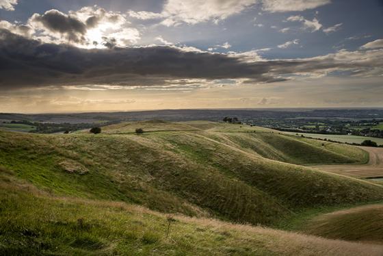
Langdean Bottom ‘circle’, looking west towards Harestone Down.

The stone row. This is definitely not a natural feature, although dating is another matter.

The northern sarsen arc, looking west.

The northern sarsen arc, less of a true circle than the southern arc, which can be seen beyond.

The southern sarsen arc.

The southern of two sarsen arcs, six stones that seem to form the side of a pretty good circle.

Landscape context from the Ridgeway, and an attempt to show the “features”.

Langdean Stone Circle
In the valley due south of the village of East Kennett stands an unrecorded stone circle, to which I have given the above name, which Mr. Crawford tells me was the title of the valley in the 17th century.


The circle as I descended into the valley. Unfortunately (!) a bunch of reprobates were hanging about the stones, so I couldn’t get a ‘clear’ shot....

Other than from the side of the valley it’s difficult to get a decent shot of the circle, and with the poor light I didn’t try very hard! I’ll try again in the summer when the light’s better & have more time!!!

The line of sarsens noted by Merrick. Cerytainly look like they’ve been moved into a line, but when & for what purpose isn’t clear. They ‘feel’ more like some kind of boundary than ‘barrow’ stones to me.

The sculpture mentioned in various fieldnotes. It’s a giraffe!!! Note horns above ears & tapering of snout. Will remove if people feel this pic is not appropriate for TMA.
According to Pete G (a local),
“The pillar with the head is a carving by local artist Jane (Can’t remember her last name) she used to live north of Avebury and had them in her garden but recently moved over to West Kennet.”
About ‘Little Avebury’ he has this to report:
“This a natural drift of sarcens in the valley floor. On top of Thorne hill is Langdean circle. There is much debate if it is a true stone circle. Meaden (’Secret of the Avebury Stones’) claims it is while Burl (’Prehistoric Avebury’) thinks it is a ruined round house. I have been there before a few times and tend to think it is a circle with a cove in the middle. The smaller circle nearby is a collection of field clearance stones.”
notes from the stones, 4 April 02:
Rarely referred to, yet obviously once an integral part of the Avebury complex of monuments, Little Avebury stone circle stood on Cow Down at the base of Furze Hill, at the point of two beautiful narrow sheltered valleys.
What a confounding and enigmatic monument in such a beautiful setting. Heading from the Sanctuary through East Kennett we took the Ridgeway south. The views back to the imposing East Kennett long barrow and Silbury gave a whole new spin on my understanding of the layout of the Avebury landscape.
After a mile or so we arrived at Cow Down (no cows, but plenty of sheep). The Modern Antiquarian marks this as the site of a stone circle ‘destroyed’. Having visited the ‘destroyed’ Falkner’s Circle earlier today and found the site clearly marked and a stone still standing, and having previously been to several ‘destroyed’ stone circles in Aberdeenshire that are still readily identifiable, I had no idea what to expect of Little Avebury.
The OS map did a great job of pinpointing Falkner’s Circle for us, but it marks nothing here.
There’s a rough circle of about 8 recumbent and broken stones – with three more heading out in a line to the south – on the valley floor at 118654, between the Ridgeway and Furze Hill.
At the end of Furze Hill there’s a *really* weird thing – a modern 12 foot tall pillar of rough white marble with a horse’s head carved in the top. About 30 metres north of that is a bit of rough ground, littered with large sarsen boulders, some fifteen of which are in a neat north-south line. If I didn’t know better I’d say it was a ruined barrow, but the lack of any MA reference and the valley-floor siting means it can’t be.
Ten metres west is another small rough circle of small recumbent sarsens.
What confuses me is none of these three sites make sense as field clearance stones. A farmer would move stone to the edge of tillable land; the side of a field or the start of a steep slope. I can see no reason why any of these stones would have been cleared to their present positions, yet none of this is an obvious circle.
Does anyone know when it was destroyed? Or of any other clues to the exact siting? Can Stukeley perhaps help us out on this one?
Still, for all this confusion I’m calmed by this hazy heat and the beautiful steep green curved valleys here.Stones or no, this place has a rich magical air.