Image credit: Chance - Aug 2013


Of the three barrows listed here, only the larger Bell Barrow survives and this too has been partly ploughed out to the north. Thankfully this northern area has now been set aside and planted up with young Beech trees. The east side of this barrow contains a row of mature beech trees which although interfering with the original ditch, do give the barrow a feeling of shelter and was welcome shade on a hot Lammas day.
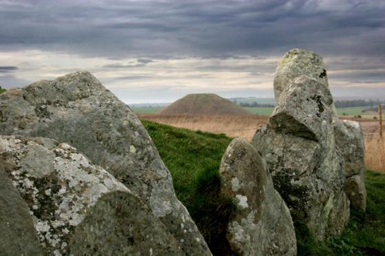
The most striking feature of this barrow is the upright sarsen mounted on its summit. Closer examination revealed two more sarsens dumped in the barrows ditch. I read on Pastscape that a lot of the barrows around here had sarsens mounted on them. This may be the result of antiquarian digging, as it seems some of the barrows were originally built over earlier structures or pits. When the barrows were first cut into, the sarsens were probably covering the original feature. One of the barrows to the north, West Down Gallops Barrows, was noted as having a sarsen.
Access
Park in the lay-by on the A361 near to where the Roman Road cut across it. Follow the Roman Road up the hill and the barrow is in the clump of beech trees to your right.
Details of Barrows on Pastscape
Two Bronze Age bowl barrows (Grinsell’s Avebury 7 & 7a) and a bell barrow (Avebury 8a) on West Down. All have suffered plough damage, with 7 and 7a now visible as cropmarks.
(’A’ SU 0711 6844; ‘B’ SU 0707 6840; ‘C’ SU 0702 6837). Tumuli (NR). (1) On West Down – Avebury 7 (B); bowl barrow 18 paces by 1 ft. Avebury 7a (A) ploughed out bowl. Avebury 8a (C) SU 0702 6837; bell barrow, mound 75 ft by 7 ft, berm 15 ft, ditch 15 ft by 1 1/2 ft, eastern half on arable, sarsen on the top. (2) Avebury 7: A ploughed down bowl barrow; diameter 19.0m, height 0.3m. Now under grass. Avebury 7a: Now represented by a vague unsurveyable ground swelling; in arable.
Avebury 8a: A bell barrow, now under grass 39.0m overall diameter, with a mound 2.2m high and ditch 0.3m deep. The intermediate berm is 3.5m wide in the W, but ploughing in the E has almost obliterated it. A line of mature trees stand on the inner edge of the ditch on the E side.
Resurveyed at 1:2500. (3)
The Bronze Age barrows were visible on air photographs. `A’ (Avebury 7a) is visible as a ring ditch with a ploughed mound in the centre, `B’ (Avebury 7) is visible as a ring-ditch. `C’ (Avebury 8a) is still visible as an earthwork mound half covered in trees. The three barrows are roughly aligned north-east south-west. Another Bronze Age barrow (SU 06 NE 142) is almost on the same alignment to the south west. (4-6)