
Approaching the barrow along the Old Bath Road track.
Image credit: A R Cane
Approaching the barrow along the Old Bath Road track.

There’s more to this than meets the eye.
From the northeast the slumped and hollowed centre is more apparent.

What lies beneath. The WW2 observation post that now fills the centre of the barrow.

Looking ESE from the top of the barrow, towards Knoll Down. The Old Bath Road trackway is the prominent earthwork leading from the barrow, another linear earthwork runs parallel with it further down the slope.

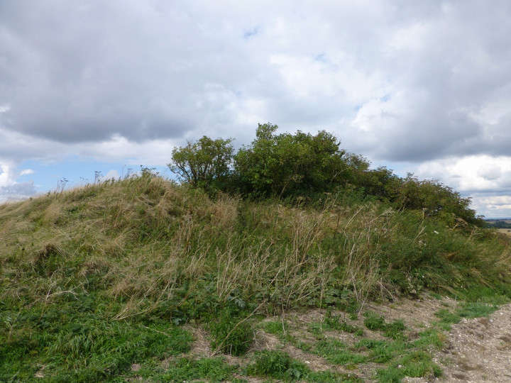
Looking west along the Old Bath Road trackway from the elevated top of the barrow. Oldbury hillfort can be seen on the skyline, far left.

The intact southern facade of the barrow.

From the southeast, this appears a very fine barrow. Appearances can sadly be deceptive.

From a distance this round barrow looks well defined and does not seem any different from the rest of the humps and bumps that scatter this section of the downs. Only when you get up close can the modern brick and concrete be seen, revealing this barrows’ mutilated core. I’ve seen lots of disfigured barrows, most the result of ploughing, some the result of quarrying and some the result of ancient treasure hunters. This one stands out though, not as the result of what was originally inside but what was placed inside in modern times.
This barrow has the misfortune to overlook Yatesbury Field on the north, West Down to the east and North Down to the south. During the dark days of 1940 when invasion by Nazi Germany was a real possibility, this site was chosen as a Royal Observer Core lookout post and its Bronze Age contents sacrificed for the good of the nation. When Sir Edmund Ironside, Commander-in-Chief Home Forces, laid out plans for the defence of Britain, this area was designated a stop-line where the opposing forces would be expected to fight to the death to stop any advance north.
The WWII structures are well preserved if very overgrown. I did not get into the slip trenches to examine the insides of the bunker as the site smelt like the dumping ground for dead badgers. The remains of the barrow are cut into by the old coach road and I wonder if the height of the barrow was extended by the spoil from the core digging.
Access
I parked up at the Knoll Down lay-by just off the A4 and walked down the old coach road which is now a bridleway. This site was one of the many barrows that are spread over the West Down area. On the south side dry valley below this barrow, runs the Knoll Down earthwork and further south and directly opposite are the two West Down Gallops Barrows.
Details of Barrow on Pastscape
Bronze Age bowl barrow, Grinsell’s Cherhill 6, still extant as an earthwork mound. The centre has been mutilated by a World War Two defence post. Beaker sherds, Middle Bronze Age sherds, fragments of shale, and human remains have been recovered from the surface of the mound by Owen Meyrick.
(SU 06746963). Tumulus (NR). (1)
North of the old Bath Road – Cherhill 6; bowl barrow, 28 paces by 8 ft. Beaker sherds, MBA sherds, fragments of shale, male forearm bone, and human teeth found superficially by O Meyrick. A back-built structure was inserted in the centre during the last war. (2) A grass and bush covered bowl barrow diameter 30.0m height 3.4m. The centre is mutilated by a wartime defence post. A side bank of the Old Bath Road overlies the S periphery of the tumulus. Published 1:2500 survey revised. (3)
The Bronze Age round barrow, described by the previous authorities has been mapped from air photographs. The World War II defence post, almost certainly associated with Yatesbury camp to the north, is clearly visible on vertical air photographs. (4)


