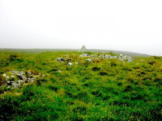
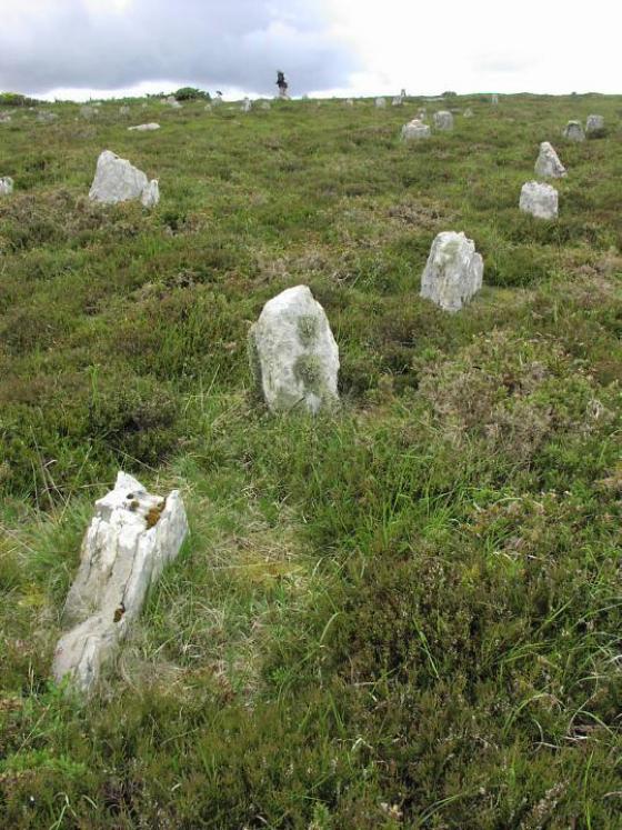
The stone rows at Tormsdale, Fig. 1, were first recorded as a result of an archaeological survey carried out by the Archaeology Branch of the Ordnance Survey in 1982 (Discovery Excav. Scot. 1982, 49). The site (NGR ND 148 497) lies on the 69m contour, approximately 3km SE of the bridge of Westerdale and 100m from the E bank of the River Thurso. To the NW is the broch of Tulach Beag, with the broch of Tulach Mor to the S. 2.8km to the SW are the stone rows of Dirlot (Thom 1971, 95) and 0. 9km to the SSE a burnt mound has been identified. The stone setting covers an area of approximately 60m x 60m and is on ground which rises only very gradually to the SE. The area is grass covered for the most part and has been colonised by soft rushes which make it difficult to identify the full extent of the rows of stones visually, since many of the stones protrude only a small distance above the surface and others appear as small hummocks on the surface where grass has grown over them........more
Articles
Sites within 20km of Tormsdale Stone Rows
-

Tulach Beag
photo 4description 1 -

Tulach Mor
photo 11description 1 -

Carn na Mairg (Carn Merk)
photo 10description 1 -

Dirlot
photo 4description 1 -

Tulach Buaile a’Chroic
photo 5description 1 -

Tulach an Fhuarain
photo 1description 1 -

Tulach Lochain Bhraseil
photo 3description 1 -

Ballone, Mybster
photo 4description 1 -

Rangag West
photo 6description 2link 3 -

Loch Rangag
photo 11description 2 -
The Great U of Stemster
photo 25forum 1description 8link 1 -

Achkinloch
photo 9description 2 -
Dorrery
photo 7description 1 -

Backlass
photo 4description 1 -

Torr Phadruig
photo 5description 1 -

Ben Dorrery
photo 3description 1 -

Balnabeinn Hut Circle
photo 3description 1 -

Dorrery
photo 4description 1 -

Torr Beag
photo 8description 1 -

Watten
photo 5description 1link 1 -

Ben Freiceadain
photo 11description 1 -

Ben Freiceadain
photo 12description 2 -

Torr Mor
photo 1description 1 -

Sordale Hill
photo 6 -

Lower Camster
photo 9description 2link 2 -

Gallow Hill
photo 8 -

Gallow Hill North
photo 4 -

Carriside
photo 4description 1 -

Cnoc na Ciste
photo 6 -

Grey Cairns of Camster
photo 67description 6link 2 -

Carriside
photo 1 -

Camster Stone Row
photo 2description 1link 1 -

Sinclair’s Sithean
photo 7 -

Shurrey, Sithean Dubh
photo 2description 1 -

Port-an-eilein
photo 1link 1 -

Shurrery Kirk
photo 2 -

Golsary
photo 4description 1 -

Torr Ban Na Gruagaich
photo 1 -

Torr Ban Na Gruagaich
photo 4description 1 -

Carn Liath, Shurrery
photo 3description 1link 1 -

Tulach Buaile Assery
photo 6description 1 -

Rumster
photo 2description 1 -
Stone Lud (Bower)
description 2link 1 -

Bridge of Broubster
photo 2description 2 -

Aultan Broubster
photo 5description 1 -

Tiantulloch
photo 6description 1 -

Tulloch of Assery
photo 6description 3link 1 -

Forse, Latheron
photo 5description 1 -

Guidebest
photo 10description 3link 1 -

Broubster
photo 5description 1 -

Houstry Broch (South)
photo 1description 2 -
Sysa
description 3 -

Minera
photo 5description 1 -

Wag of Forse
photo 8description 1 -
Forse House
description 1 -
Forse House
description 2 -

Buoldhu
photo 2description 1 -

Cuag
photo 3description 1 -

Cnoc Na Maranaich
photo 6 -

Cnoc Na Maranaich
photo 14description 1 -

Cnoc Na Maranaich
photo 6 -

South Yarrows N
photo 4description 1link 1 -

South Yarrows S
photo 14description 1link 1 -

Buldoo
photo 14forum 1description 3link 2 -
Loch of Yarrows Archaeological Trail
description 1 -

South Yarrows Broch
photo 13description 1link 1 -

Burn of Houstry
photo 4description 1 -

Warehouse N
photo 6description 2 -

Warehouse S
photo 12description 2 -

Loedebest West
photo 8 -

Loedebest
photo 2 -

Carn Liath
photo 12description 1 -

Warehouse E
photo 8description 2 -
Burn Of Swartigill
description 3 -

Loedebest Wood
photo 4description 1 -

Upper Latheron
photo 5description 1 -

Garrywhin
photo 9 -

Kenny’s Cairn
photo 13description 1 -
Hill O’Many Stanes
photo 18description 6link 3 -

Garrywhin Stone Rows
photo 5 -

Garrywhin Cists
photo 8description 2 -

Garrywhin
photo 23forum 1description 4 -

Dunbrae
photo 1description 1 -

Thrumster Mains
photo 7description 1 -

Knockinnon
photo 3description 1 -

Watenan South
photo 6description 1 -

Balantrath
photo 3description 1 -

Borrowston
photo 4description 1 -

Bruan
photo 2description 3link 1 -

Thrumster Little
photo 5description 1 -

Dunbeath Broch
photo 13description 2 -
East Murkle
description 1 -
Gansclet
description 1 -

Thing’s Va
photo 6description 2link 1