STANNON STONE CIRCLE...a return visit.
5th October 2013.
This was my second visit to Stannon stone circle, the first being in May 2012 when it was a dull, over-cast and windy day.
I’d come back for one main reason if truth be told, and that was to see if the negativity I felt there the first time around would still be with me, but this time it was a reasonably sunny day with a light wind so I was hoping for better things.
This circle, in common with Louden circle to the south-east and Fernacre circle directly to the east nestling beneath the southern slopes of Roughtor, has been termed a ‘ceremonial’ circle. This appears to be mainly because of their size, being the three largest circles in Cornwall (aside from the Stripple Stones which is a henge site) and not based on any actual tangible evidence that they were used for this purpose.
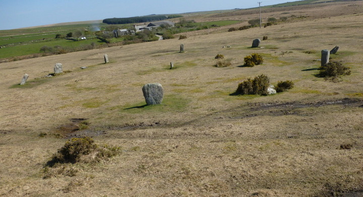
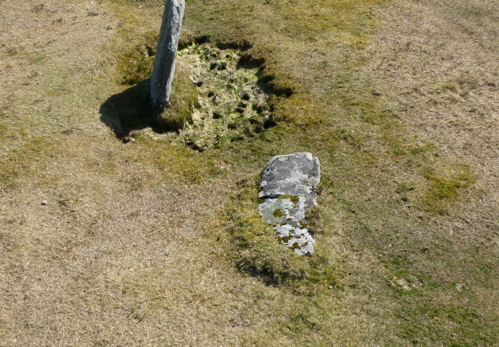
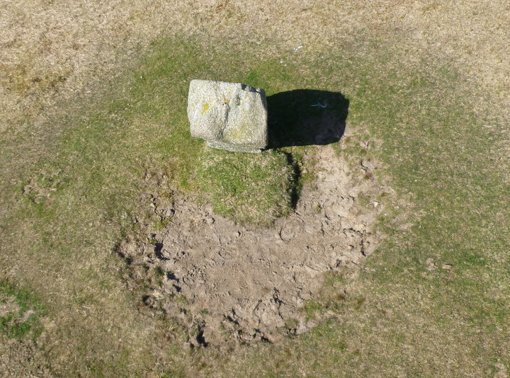
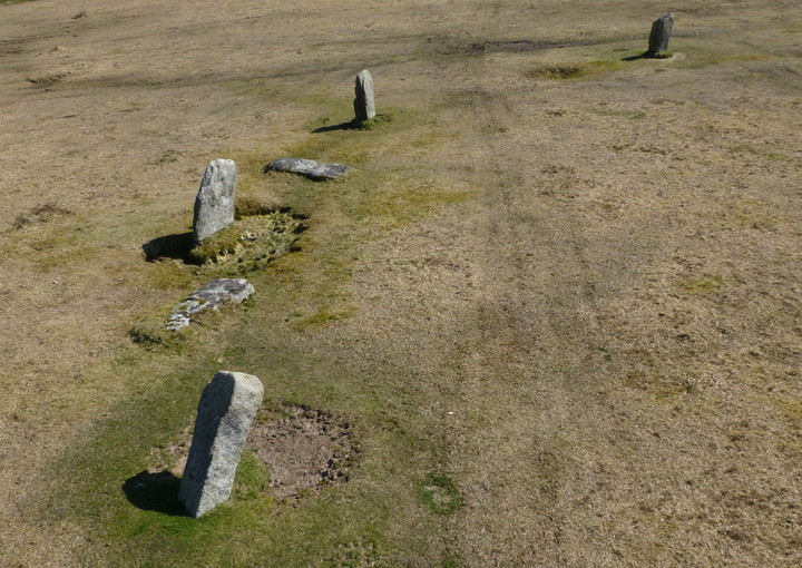
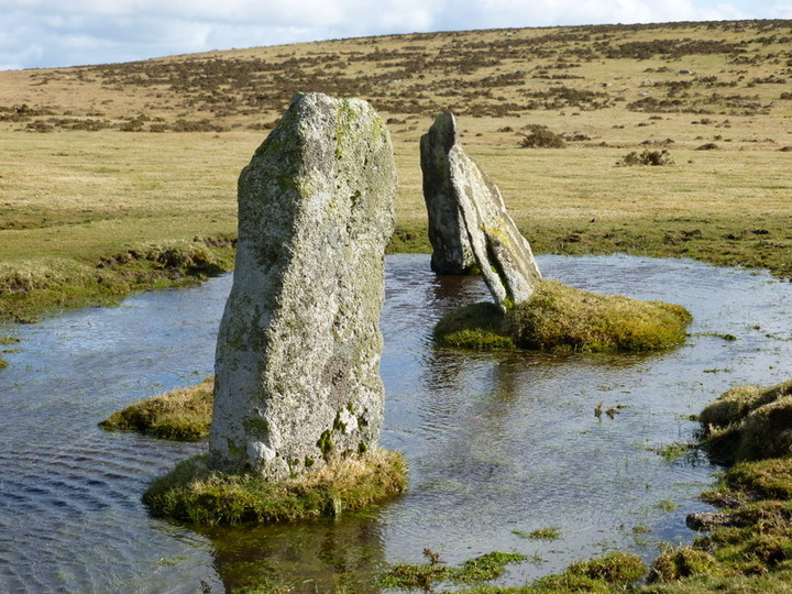
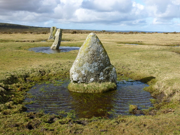
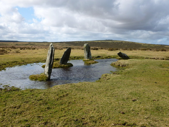
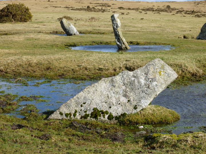
Stannon Circle, although not strictly circular, being a mixture of curves and a selection of short straighter segments, is officially 139’-8” x 132’-10” (PastScape) in diameter but that depends entirely on where exactly you take the measurements from, and has between 70-80 stones in its setting in various shapes and sizes and either standing or fallen, but mainly on the smaller size and gives the circle an almost unimpressive look to it for one so large. There is a flattened, well bedded stone, lying off-centre within the circle which may or may not be part of the original build. The locally sourced granite stones to the south-west sector would appear to be the tallest at about a metre high with the remaining standing stones around 0.5 metres with the exception of a large magnificent leaning triangular stone directly west. Those in the north-west quadrant seem to be the most regular in height, type and spacing, with the north and south-east quadrants being rather flattened, small and unevenly spaced. I got the impression that a lot of the stones in these last named areas have suffered the most over the years and possibly been damaged/moved by farm vehicles and replaced randomly closing up many of the more regular spacing’s.
Because of my principal interest in them, the magnificent triangular stone within the setting was the first stone I concentrated on as both Louden and Fernacre circles boast the same such singular flagship stone. I carefully, as best I could taking into consideration that the circle is not truly circular, calculated the exact centre of the monument and took a compass reading. The stone is exactly due west and not slightly NW as I had previously poorly recorded due to me not marking out the centre of the circle more accurately, another reason I felt the need to return.
What hadn’t changed however from my previous field-notes or my thoughts, was the ‘ceremonial’ label that had been bestowed upon this circle and it troubles me.
The term ceremonial to my mind indicates a circle that was built and used for special occasions and because of this on my previous visit was expecting a beautifully crafted true circle with specially selected or even dressed larger stones similar to those at the Hurlers for its setting…not a mish-mash of unregulated rough stones of all differing shapes and predominantly small literally thrown together in a poor attempt at forming a true circle! Working northwards from the triangular stone it started well, but midway along the west to east northern sectors it sort of fell apart! Why? What happened to the grandeur that one would (today) normally expect of a ceremonial monument?
It wasn’t like there was a shortage of larger stones on the moor as they lie everywhere. The transportation of heavy and bulky stones doesn’t appear to have been much of a hindrance to our Late Neolithic/Early Bronze-Age ancestors as seen elsewhere, so why the totally unimpressive array of random small stones instead of those that would have made a statement of the importance of the monument? It is this that puzzles me the most.
Looking around the circle I was drawn to a section to the south-west where the setting looked somewhat different to the rest with those previously mentioned taller stones seemingly purposely erected closer together and more ‘group’ like with some smaller random stones lying around the base of them. My first thought was that ‘something’ took place in this area which seemed to be at the juncture of two straighter sections...but what?
In common with most Bodmin Moor circles, although on this occasion somewhat masked due to the build-up of the china clay banking, Roughtor is in the background overseeing all before it and I won’t be alone in thinking that it was likely to have once been revered by our great ancestors who built these circles.
As for the negativity I felt here last time, well it was more of a bereft feeling this time, but there was more. I still felt that whatever the circle had once stood for was now gone along with its builders and that saddened me, but I still felt that this circle was not understood and it was erected as part of something else and not as a ‘stand alone’ circle.
It was only when I got back home and reflected on what I’d seen and thought at the time that I began to look at things differently. Prior to my initial visit to Stannon, I’d never before left a stone circle behind feeling unsatisfied with what I’d seen and never have again since. One of my reasons for returning, as I have already mentioned, was to check out the triangular stone and it was this that set me thinking again. What special significance could the triangular stones have held to be featured so prominently in the three large circles on this part of Bodmin Moor and what could their separate positions within each circle reveal? Stannon’s triangular stone is due west in its setting, Fernacre’s due east and Louden’s due south. Oddly enough, Stannon circle itself is to the west, Fernacre is to the east and Louden to the south on this section of the moor, so their triangular stones are all on their outermost perimeters of West/East/South…and linked up, the three circles form a triangle themselves! Could this be significant or pure speculation?
The similarities the three circles share could well tell a story. Similar in size, all irregular circles, all built of mainly small stones, all having an impressive singular triangular stone and all within close sight of Roughtor. This suggests to me that they were built by the same people and part of a much greater plan and all at the same time. Were they built to interact with each other and not so important as individual circles after all? In fact why would you require three ‘Ceremonial’ circles within a short distance of each other? Why was one not enough to serve such a small area or community?
Is that why I felt the negativity with Stannon circle because it really was built for a different reason and was not a ‘stand-alone’ circle with a separate function after all? That could possibly explain the three circles apparent lack of quality construction and only roughly circular shapes, but I think I ought to stop there as I’m in danger of over-speculating again…something I can get very good at, but will nevertheless no doubt try to expand on in time! Questions, questions!
|
Visit date: 4th May 2012
The original plan was to drive to Middle Moor Cross by Camperdown Farm, park up and walk to Fernacre stone circle via Louden circle, a round trip of about 3 miles, as the road/track from the cross is private. Well that was the plan, but it changed when a friend suggested we take her 4x4 and drive beyond the cross and continue along the private track to both circles. We set out on the A30 and took the turning right signposted St Breward opposite the second turning for Temple on the left. It comes at the end of a section of dual carriageway after passing the Jamaica Inn on your left 4 miles prior to this.
This moorland road takes you passed the Trippet Stones on your right at the crossroad signposted Treswigga to the left and St Breward straight on. Turn right here if visiting the Trippets which can be seen from this point.
Continue on the St Breward road by following the signposts and you’ll pass over Delford Bridge then passed East Rose holiday park/fishing on the right. Straight through the next crossroad which in turn brings you to another to the northern end of St Breward at Churchtown. Church Hay Down is on your right at this crossroad and you turn right here signposted Candra. Follow this road which bears around to the right after half a mile and after another bend, over a cattle grid. You’ll then pass the road to Candra Hill on the right and part of the Treswallock Downs which is littered with huge boulders. No shortage of building materials here! The road then sweeps around to the left but as it does there is a short ‘link’ road to the right that you take and then right again on meeting the ‘main’ road which takes you directly to Middle Moor Cross.
Now it was decision time, because you hit a PRIVATE road which is clearly signed. After consideration we decided to take a chance and go for it. We continued and soon met another private road sign at Camperdown Farm, so now had been warned twice. Rightly or wrongly we again decided to continue because there wasn’t a soul about as far as the eye could see. Within five minutes I spotted on the horizon of the slightly rising ground a dark shape on the moor on the right-hand size of the track. Yep, it was the leaning triangular stone of the Louden circle our first port of call. I loved it and gave me a much nicer feel than I got at Stannon stone circle just over the way by the dreadful china clay quarry next to it! These are big circles in this area of Bodmin Moor but surprisingly the majority of the stones are really quite small in comparison to other Cornish circles and it remains a mystery to me why that should be so. Louden, Stannon and Fernacre all have a major triangular stone and this must surely signify something of significance, but what? No common point on the compass as far as I could tell, but have no knowledge of any celestial alignments that may come into play as that is not my thing!
I counted 36 stones in total at Louden but three were just under the turf. The triangular stone was due south from the centre of the circle. Most of the stones are virtually at surface level but not broken, so it surely indicates a build-up of soil over the years as the stones have sunk into the peaty soil. In the gapped areas I probed the turf with a dowsing rod which my friend carried and discovered three more stones where they should have been in the ring setting just covered with an inch or two of turf. I didn’t count those that were lying immediately to the sides of a couple of stones as they were quite small and possibly broken off the main stone. I would imagine that later in the summer (this was the 4th May) that other than the triangular stone, Louden could be difficult to find due to increased grass length, but once you have found it there is no mistaking it. One clue is that just yards to the east of the circle on the edge of the track on the southern side is a stainless steel ‘box’ nearly at ground level with the letters PO on it.
As at most circles on the moor there are always other stones lying around and it is a hopeless task even considering whether they are part of the site or not. Not shown on my OS map but just across the track from the circle and slightly to the east is what appears to be a lovely stone ring cairn. Close inspection showed it to have been constructed in three stages I thought with three separate rings of edging stones forming it away from the burial area. It was all a bit ‘interfered’ with but that’s what I gathered by close inspection and one is led to believing it may have had a connection with the circle in some way.
Link to photos here:-
https://picasaweb.google.com/100525707086862773355/LoudenStoneCircle?authkey=Gv1sRgCJ3b5YqlqK6vBA#5739140100505851778
|
The Stripple Stones…Hawks Tor Downs, Blisland, Cornwall. (SX14357521)
Visit date: 5th July 2013
With just two more stone circles to visit on Bodmin’s moors (Leaze would be the last one after this visit) I set out on a beautiful Friday morning to search out the Stripple Stones on Hawks Tor Downs.
This one was of special interest to me because it is a stone circle 47 yards in diameter set within a henge some 58 yards in diameter and the only such one in Cornwall, so I was really looking forward to that moment when you cast your eyes on a new circle for the first time, especially one so special.
I began my walk from the Trippet Stones on Manor Common which reaches down to the main A30 road through Cornwall. The turn-off to the Trippet Stones on the A30 is from the Temple crossroads about four miles from the Jamaica Inn away to the east. Take the right turn signposted St Breward and a mile or so up this moorland road take the road/track to the right at a small crossroad signposted Treswigga to the left. About 200 yards up this gravelled track and the Trippets can be seen on the left. Park just off the track but please don’t drive up to the circle as the ground is very peaty here and cuts up easily.
As the land leading to the Stripple Stones is mainly private you either have to seek permission from the landowner at Hawks Tor Farm at the end of the track, or, take a chance and do what I did and take a round-about route to get there via a well worn working track leading up to the lower reaches of Hawks Tor.
So, from the Trippet Stones and with Hawkstor to the east in front of you away in the distance, I headed off diagonally to the left of Hawkstor Farm until I met the boundary wall/hedge and followed it down to a gate. Lovely old stone walling on the left leading up to the gate. This is the route the local landowner and probably other Commoners take to bring cattle on and off this part of the moor so it is well worn.
Through the gate and begin the walk up a longish track past a ‘working area’ on the left and a series of cattle pens and runs. Note the huge flat upright stones set into the walling on the right alongside a gateway to the right. Two more gates to negotiate (I had to climb both as they were secure to keep the cattle in) then the gate leading onto the open moor.
Ahead of you to the right are the lower reaches of Hawks Tor and it was then that I remembered why I had decided not to bring my Border Collie Chief with me for the first time ever. Gorse, rocks, dense shrub grass…and the possibility of adders! I’d heard on the news just two days earlier that 13 dogs had been bitten over the moors in a month so there was no way I was going to let my normally constant travelling companion risk running the gauntlet here.
A bit of a climb gets you to the top with the usual outstanding views around Cornwall on display. Off to the north are our two national landmarks of Roughtor and Brown Willy and forward of them, Garrow Tor. What tales they could collectively tell of the goings on over the centuries that’s for sure! To the south is the A30 and beyond it Colliford Lake.
From here I walked due south to the base of the Tor until meeting a timber gate leading into a large paddock with sheep enclosed. In the distance but slightly to the left I could just make out the circular shape of the henge and a few standing stones which were well apart. I had only just began to walk toward them when I realised there was a lower fence-line so had to turn immediately left from the gateway I had only just passed through and follow the fence-line until reaching another gate about 100 yards away. Through that then immediately turn right and the Stripple Stones are about 300 yards ahead of you.
Well, the moment had come, but I have to admit to feeling rather disappointed on first close up view as the henge is only these days a mere shadow of its former self. Cattle and mans determination to totally disregard our heritage have played their hand yet again! Just four stones left standing and ten more lying prostrate, including a central pillar, were all I could find from what is believed to have been around 28-30.
Worse was to come. Built right across the north-eastern sector of the stone circle, ditch and bank is a stone and earthen boundary wall/bank which no doubt included the broken remains of those removed stones. It beggars belief that in this landscape of nothingness other than an area of outstanding beauty, the perpetrators of this - what to my mind is a criminal act - could not have avoided the henge altogether.
To me it is quite simple and I no longer accept excuses. Generation after generation of landowners simply don’t care and are prepared to see our past destroyed because it is of no interest or value to them. Even though there are thousands of acres of Bodmin Moor for stock to roam over, nobody it seems is prepared to give up the comparatively small areas of land these circles are built on and erect protective fencing or traditionally built walls in keeping with the environment to keep them safe! This is a henge site for heavens sake and the only one in Cornwall with a stone circle within it. How much more important must a site be before someone takes this matter seriously? Out of sight, out of mind, would appear to be the case here due to its location.
Little remains to be seen now of the ditch or bank as again they are being wiped out by wondering stock. It has almost certainly been accelerated over the past decade as Highland Cattle have become very popular over the moor. These massive beasts are like tanks wondering the landscape with not much standing in their way and particularly noticed near the Trippet Stones circle just a stones throw away on Manor Common. It has been said that the cattle do very little damage to the archaeology taking into account just how long in the main most of the sites have been here, but surely they are living in cloud-cuckoo land if they really believe that! A herd will walk through a stone circle using every stone as rubbing posts if the mood takes them and for every altercation between beasts every stone in their path is in imminent danger due to the soft peaty soil many are erected on!
I took the reverse route back but on descending the Tor noticed farmer workers along the lower track removing cattle from a trailer so hung back for a few minutes. On completion they then drove a quad bike up the trailer ramp before moving off. I thought I was safe but on emerging out of the track-way noticed they had parked up and were letting three or four collies loose for a drink in the stream that passes through at this point. I manned-up for a confrontation and continued walking but other than a cursory glance back by the driver, they paid no further attention to me and drove off.
On reaching my car some 15 minutes later, I was to get the shock of my life, for in the distance I could see and hear the same guys returning both in the truck and quad bike, but this time driving cattle across the common – directly toward the Trippet Stones!
I quickly got out my camcorder and filmed them drive the cattle straight through the stone circle without an apparent care in the world. http://youtu.be/sYOs73GLvrs
It’s as I have already said, nobody cares! Just one week earlier the Commoners had been warned about driving vehicles and stock through the circle by Natural England so this just proved the total disregard shown by them. On this occasion neither vehicle passed through the circle although the truck was pretty close but the cattle sure did! I am at a complete loss as to why sites such as this can’t be protected efficiently but sympathetically. I reported the incident to English Heritage and sent them the clip of the video but have now all but given up my fight to have these sites protected as nobody listens. The ongoing excuse is always the same…lack of funds, but they seem to be found for other projects felt more interesting and potentially money making!
|
Craddock Moor Stone Circle 15th January 2013
I paid a return visit to this circle today to see if I could find some of the stones now lost to nature lying under the turf and gorse. The last time I was here there were about 15 stones showing, all recumbant and some only just identified by small patches of granite showing through the turf. Using a broken shaft from a steel shafted golf club I was able to probe the soft peaty soil and found 7 more stones within the setting, one of them being over 7 feet long and to the north-west of the circle. This is the tallest I have detected here. So I now know of 22 in total. Such a shame that this circle, just a stones throw from the 'flagship' Hurlers at Minions is being totally ignored and neglected because it isn't in the public gaze like the favoured ones.
|
Crowpound.
Visit Date: 9th November 2012
It was only recently that I got to hear of Crowpound after it was suggested that it was rather like King Arthur’s Hall on King Arthur’s Down to the north-west of Bodmin Moor. As KAH is a particular favourite of mine a visit was top of my list.
I have to say that on first appearance it disappointed me as other than a rectangular banked earthwork enclosure it bears little other resemblance to it. There is no grandeur to it and no ambiance as there is at KAH and certainly no granite standing stones lining the inner side of the bank.
I approached the site after leaving the A30 taking the St Neot turn-of and passing Colliford Lake on the LHS. At Fair View/Williams Cottage at a four junctioned xroad you continue south for about another ¾ mile sign posted Mount/Ley before reaching a further xroad. To the left takes you to St Neot and the right to Mount. Go straight over and Crowpound is immediately on your right and makes up the south-east corner junction of the xroad.
Basically it is a rectangular banked earthwork of uncertain age and usage, the middle of the site having been extensively mined and left in an appalling state as far as I am concerned. Why disturbed land was never reinstated by the mining companies is beyond me as it remains such a mess. Holes all over the place with the removed earth banked up alongside. To the middle central area of the enclosure is a somewhat crude interrupted circular banked area which is somewhat of a puzzle, but in amongst all the mining holes and earth deposits its identity simply isn’t clear cut although my first thought I have to say was that it could be an open earthen ringed cairn and the real jewel in the crown of this site. The northern end of the central inner area is quite flat and untouched by mine works so my thoughts are that on first build the whole inner area was a flat surface with the possible exception of this central circular earthwork/ringed cairn with the banked enclosure coming later. Only excavation will resolve that possibility however.
Where it mainly differs, other than having no standing stones to the inner sides of the banks like at KAH, is the consistency and height of the banking. Very neat and tidy with perfectly level tops about 4ft high, whereas the banks at KAH are a bit up and down and somewhat irregular in places and much higher and bulkier. My first thoughts again on seeing this (and now wearing my builders hat) was that they were built level to then take a possible fence to form a perfect stockade to keep animals in. The banks themselves ‘seem’ to have been formed by removing earth from the inner surface but could equally have been brought in from elsewhere and deposited there. As the photos will show there is water lying against the inner base of some of the banking suggesting it was from a shallow ditch left behind after the earth was taken to form the banking, but this is a little sketchy to say the least.
What troubled me the most was that the site had no ‘feeling’ to it and left me cold. It was plain, simple, every-dayish if you like with no heart. It simply did nothing for me and it certainly didn’t feel ‘old’. Inside of me I didn’t want it to be like KAH as that is a special place and in that respect it didn’t let me down!
Now, interestingly, about a quarter of a mile away to the south-east on Goonzion Downs, is a tumulus and lo and behold it is held within another enclosure made up of the same type of banking as more photos will show. A very large enclosure this time with the tumulus set almost into its south-east corner. What’s all that about you have to ask? The tumulus itself has been dug into with the centre torn apart and another example no doubt of treasure seeking morons with no respect for our heritage and/or our great ancestors last resting place! Overall though this entire area has been destroyed by mining works and it does make you wonder if in days gone by anyone really cared a stuff for our past or even once considered re-instating the land back to its former beauty.
https://picasaweb.google.com/100525707086862773355/Crowpound?authkey=Gv1sRgCNKN6Y_isObUOQ#
|
Site re-visit date: 20th Sept 2012.
Whilst I was making a quick return to Zennor Quoit I also dropped in to Carn Euny again to see the fogou. It was whilst coming out of the rear entrance to the fogou that Indy, my other dog and son of Chief, stood on a slightly rocking flat stone to the side of the path. Feeling I should lift it, I did, and was surprised to find it covered a natural water supply about a metre down. Thinking no more about it other than, 'Oh they were okay for water then' I just carried on. On leaving, I took the longer path back to the car park and got a real surprise as I left the site, as on the right-hand side immediately adjacent to the site boundary, was a HUGE stone and beneath it a well...a Holy Well along with the traditional blackthorn adorned with ribbons and the usual trinkets and coins pressed into its bark and other orifices. It was a lovely thing to see I must admit and obviously at the same water table level as the 'well' at the 'rear' entrance to the fogou, which although only a small opening (may have been narrowed because of the path) showed an 'emergency' water supply for the fogou users possibly?
I took a few pix as growing out of the top of the huge 'capstone' was a tree would you believe with its roots travelling down the stone and into the ground! Here they are:-
https://picasaweb.google.com/100525707086862773355/HolyWell?authkey=Gv1sRgCI688ZD2lsSj9QE#
|
Site visit: 20th September 2012.
I made this flying visit back to Zennor for two reasons. Firstly, I wanted to see it and the surrounding landscape without a blanket of fog surrounding it, and secondly, I had read of the Borlase account of the farmer being paid 5 shillings to stop breaking up the stones to use as a cow shed or field shelter, so thought I would check this out.
I wasn't to be disappointed on both accounts. On a clear day this time the landscape was, as one would expect in a moorland setting, remote, haunting but with a feeling of peace in the air. After yet another look around the quoit but this time taking full measurements, orientations etc I had a very close look at the right-hand side front facade stone. Narrower in width to its partner on the left it is also, today, short in height compared to it. The reason, because this is one of the stones to be desecrated by the said farmer. As the photos show, a close look at the top of this stone shows the drill holes made either side of this facade stone where the steel wedges were inserted to split the stone and coincidentally, in the background, the very stones that were split off as if cocking a snoop at us set amongst others!
As the holes are randomly drilled it will be an easy task to seek out the two? sections of stone removed off the top of the facade stone by measuring the gaps between the semi-circular drill holes on both the facade stone and the ones used as uprights to the shelter. This I will do on my next visit after I have made a 'sliding template' to make life easier for myself.
https://picasaweb.google.com/100525707086862773355/ZENNOR?authkey=Gv1sRgCNWevuuX_rjRHg#5792007563200663426
|
Carn Euny:
Visit date: September 3rd 2012
Aside from Zennor Quoit, this surprisingly made my short break in Penwith that bit special. Not normally being an IA Settlement person I nevertheless went to see Carn Euny while I was close by. Boy oh boy what a surprise I got because I got to see my first Fogou (pronounced Foo Goo I am informed) and it blew me away. It was like entering a Neolithic Long Barrow but without any side chambers and you went in one end and came out the other! In other words it was a tunnel but so much more which you'll understand when you see it for yourself. To the right of the main entrance of the fogou was another smaller entrance which lead to a circular 'room' with a circular roof ventilator/light. It was this chamber that is the WOW factor and as I was filming it with my camcorder I couldn't stop talking into its mic. Both the circular walls of the chamber and the straight walls of the main fogou were neatly constructed to their lower sections and had a breen/blue tinge to them but above that the quality of the stone laying became less 'skilfull' I felt. This is probably down to the reconstruction work that has taken place which in itself was disappointing because it appeared like modern construction workers hadn't either the skill or not taken the time to equal our great ancestors quality of work. Prior to visiting a fogou I had understood them to have been a product of the Bronze Age (so I'd read) but it seems they are more from the Early IA. The construction of the stonework is probably a good indication of that compared to the Bronze or Late Neolithic.
I reached the site easily enough. Take the Sancreed turning off the A30 and simply follow the plentiful signs to Carn Euny. The parking space is on a firm standing and would be large enough for around 6 or seven vehicles. There are two paths on offer to reach the site from there although the one off to the right alongside the house can be wet and muddy as it goes across a field and a couple of stiles.
But I loved it here and had the benefit of a lovely sunny day which was such a bonus after the poor summer we have had in 2012. The layout of the round houses in the village is quite a charming sight and it was obviously a very close-knit community in its heyday. Loved it!
I took loads of pix but haven't uploaded any as there are plenty of the same already on display.
Oh and one last thing...access to the site is FREE!
|
BOSCAWEN-UN
Site visit 3rd September 2012
Travelling westwards on the A30 toward Land’s End and just prior to the turning right to Sancreed, you will see a rectangular double-brown sign at the entrance to a driveway on the left with Boscawenoon and Chyandwens Farmhouse written on them.
https://picasaweb.google.com/100525707086862773355/Sign?authkey=Gv1sRgCMeCmdr3uuGXOg#5786107750162643298
It is a public footpath but a driveway as well up to the aforementioned properties. I drove up very nearly to the farm until reaching a very nice long pull-in on the right adjacent to a tall pointed standing stone built into the hedge/wall.
https://picasaweb.google.com/100525707086862773355/PointyStandingStone?authkey=Gv1sRgCO_L6YO00rLDkQE#5786072636533751618
We (the dogs and I) then walked down the driveway passing some farm buildings on the left and followed the driveway around to the right and past a house and a building described as a ‘goat shed’ on a sign. We continued on and came to a divide in the driveway with a vertical sign between the two declaring Boscawen-un was straight ahead!
https://picasaweb.google.com/100525707086862773355/Sign02?authkey=Gv1sRgCLLD6ZmL68AS#5786075139480626370
Take the path to the right which is like a high-hedged alleyway. Midway along you will come to a stile on the left showing the right of way but don’t go over it keep straight on up the alleyway until reaching the Boscawen-un stone circle gate and sign on the left.
https://picasaweb.google.com/100525707086862773355/Sign2?authkey=Gv1sRgCPauu9LBseqOmwE#5786077122101774018
MAGICAL was the word that popped into my head on seeing the circle as it truly is. This is a ‘good place’ as indicated by my dog Chief who ‘reads’ sites really well and immediately ran from stone to stone investigating in a happy manner. It’s not always like this with him.
Not a soul other than us present and quiet as could be and the site as tidy as I have ever seen one. The message may be getting through at last! The circle itself in a lovely sheltered setting sat there in complete serenity. The stones are pretty much regular in size/height with just either one missing or the space an entrance possibly and of course the well-known leaning off-centre stone such a feature. It looks ‘worked’ to me with a central spine forming two upper faces. If I know little of a site prior to a visit, I tend to not swot up on it so that I go with no preconceived ideas in my head, so that I can form my own opinion first before it becomes polluted with the usual bog standard interpretations. The spine on the leaning stone certainly gives one the impression that it was meant to be ‘pointing’ but that is pure speculation on my part. Whatever, it is a truly wonderful site to visit.
As I left the site through the gated entrance a couple of young ladies with multi-coloured hair:-) were approaching from further up the ‘alleyway’ loaded up with camping gear, so presumable the public footpath also extends back to a road somewhere further along the way.
A few photos:
https://picasaweb.google.com/100525707086862773355/BoscawenCircle?authkey=Gv1sRgCPbanpf0mPnnygE#5786080117076506018
Roy
|
Zennor Quoit
Site visit 4th September 2012
Well I couldn’t have chosen a better day if my intention was to not find this iconic Penwith site as it was completely fog/mist bound!
I had approached the area via the B3306 road from the east (St Ives end) heading for the Eagle’s Nest house which thesweetcheat had mentioned was in the area marked as Higher Tregarthen on the OS 1:25 map (102). It was so foggy that I drove past the house three times looking for its name and never did see it, even when I walked by after parking up.
So, coming from the east, I parked in a small parking place on the left about a hundred yards prior to the house which is on the right on the very brow of the hill. As you climb the hill you will notice an outcrop of rock not unlike a small tor on the left very close to the parking spot https://picasaweb.google.com/100525707086862773355/ZennorLandmarks?authkey=Gv1sRgCPar6of71Z_COQ#5785902295554289986
Walking from there with my two dogs Chief and Indy, I stood near a building to the right-hand side of the house
https://picasaweb.google.com/100525707086862773355/ZennorLandmarks2?authkey=Gv1sRgCKz4vK2l1-3D3QE#5785903498007072818
and looked directly across the road. It was so foggy I could barely see across to the other side, although when I took the photos on my return it was much clearer! Across the road was a collection of boulders that had been placed across a ‘path’ that went off into the distance.
https://picasaweb.google.com/100525707086862773355/Zennor3?authkey=Gv1sRgCL2fy5_i9LLVKg#5785905121013105186
It wasn’t even a track as such as it was so overgrown but I felt I ought to try it as I could see nothing else remotely like a track due to the fog. As we ventured into the mist the thought went through my head that I must be nuts to even consider venturing out into unknown territory in such conditions…but we did! After about two hundred yards the track came to an ‘entrance’ flanked by two stone posts which I passed through. So far so good.
https://picasaweb.google.com/100525707086862773355/Zennor4?authkey=Gv1sRgCJSx8-y3xdPRyQE#5785906039772289314
On and on we went and it was noticeable that this tiny track only some 18” wide at best was bearing around to the right in a large curve. Other than that I could see zilch. The gorse is impenetrable so you just have to stick to the path and make sure you are wearing tough old jeans or leathers.
After about 20 minutes of pretty slow going we arrived at a derelict building called the Carne I believe. TSC suggested turning left south-east here and I took that to mean you walked alongside the building before turning, but I was wrong as it is just a dead end after the building. At this point I thought it too risky to carry on because only metres from the building it was lost in the fog and I felt a complete idiot for even attempting it.
So I decided to turn back but had only retreated about 40 yards back down the track when I saw Chief disappear off to the right. Aha I thought, is this the ‘left’ path? So, following close behind the dogs I ventured on and after another 2/3 hundred yards the track widened right out to something like 20ft wide with the tiny worn path still running down the middle of it. That cheered me up because I knew we were now on the right track but why it took so long to widen out was a bit of a mystery to me!
After about another two hundred yards the dogs suddenly shot off to the right again up another track. I saw them start but they soon disappeared into the fog so I decided to follow. Lucky I did, because within a few seconds Zennor Quoit loomed up out of the fog. Phew, we’d made it but what a journey. It wasn’t the distance so much but the tension of not really knowing where I was that slowed everything down and put me on edge.
But, we were here and it was magical and if as by magic, the fog suddenly began to lift and actually added to the experienced and I quickly got on taking pix and shooting a vid.
https://picasaweb.google.com/100525707086862773355/Zennor5?authkey=Gv1sRgCKeUkKCcztKgFA#5785907009353388146
All sorts of questions were going through my mind about this quoit as I filmed and my first impression was that the capstone had only slid to the rear and to the right-hand side and not off a tall back-stone as shown in Borlase’s sketch of 1769. I wondered why they had gone to the effort of shaping huge side flanking stones if the slope on them was not to be accommodated by the capstone as it is now as such. Looking inside the chamber where bones or cremations would have been placed, there is a stone leaning the full width of the chamber that if raised fully would fit exactly where a back-stone should be as it would be level with the top of the sloping section at that point. But, if the lid was really up high then we have to accept that unless Borlase drew what he assumed it would have been like originally, then that’s how it really was…at that time at least! It does puzzle me somewhat though that he shows the now missing rear support as being almost needle-sharp and very slender for a stone that is supporting such a vast and heavy capstone that other than that only rested on the front closure at the opposite end.
https://picasaweb.google.com/100525707086862773355/ZennorQuoit#5784957939740525794
Another puzzle is why he assumed it was completely covered at one stage seeing that there would have been such huge gaps that would allow the ingress of cairn material into the burial chamber. If it was to be covered then it would have been boxed in full height surely and not have sloping sides. Its complete covering had to be pure speculation on his part, possibly spurred on by the material he shows to the lower regions which to my mind (more speculation) would only be there to add rigidity to the base.
That apart, it is a wonderful sight to behold. Heaven alone knows how long it took them to shape those angled side flankers and prepare the front closure and raise the lid. The façade stones are just as big and you can only admire the tenacity of the builders for undertaking such a task without the benefit of the machinery at our disposal today. I assume the main orthostat is earth-fast otherwise it would have been down now for sure.
It was disappointing that the fog prevented me from observing the landscape surrounding the quoit but that’s how it is sometimes on the Cornish sites so close to the sea, but I will return. Getting there for me was a challenge when the fog blanked it all out but it tested and confirmed my great will to still defy the conditions in the quest to appreciate what our great ancestors left behind for us. I hope it never leaves me for what is life when your sense of adventure and thirst for knowledge is no more!
Photos:
https://picasaweb.google.com/100525707086862773355/ZennorQuoitPhotos?authkey=Gv1sRgCL2kwqWT76aaOg#
Roy
|
Duloe Stone Circle. Visit date: 27th June 2012.
There's something about Duloe stone circle that draws me back whenever the opportunity arises and normally that’s when we’re off to Looe for the day. But today it was different as it was a ‘Duloe only’ day with nothing else to sidetrack me.
Parking, unless illegally, is not possible outside of the cutting between the properties leading to the circle, so one has to park in the road behind the close-at-hand St Cuby church where there is a large lay-bye.
Once parked up it’s only a two or three minute walk back to the cut-way which is adequately signed on the roadside opposite.
Always my first impression when approaching the circle is what a little gem it is. Unlike all other stone circles, dolmans, standing stones and burial chambers in Cornwall that are granite, Duloe’s circle is of quartz and must have been quite dazzling on first build. Another obvious peculiarity is that unlike the major large open circles in Cornwall built with mainly smaller stones, this small circle has mainly huge stones in comparison! Does this offer us a clue to its meaning and use I wonder?
The largest or tallest stones lies due south and there are 4 definite ‘compass stones’ to the N,S,E & W and are all the larger ones of the eight present. The very small stone to the south east is an additional stone just placed on the surface in modern times and not part of the original build. I did consider moving it as two other groups of visitors arrived while I was there and par for the course started counting the stones which of course came to nine. I pointed out the error which they thanked me for but if you don’t then of course they go away with a slightly false impression. I left it where it was but it just moves if you touch it anyway so won’t fool many at this time. I’d like to know where it came from though and if it was off one of the others or just a random chunk dug up in the field.
Historically a bank/hedge ran either through the middle or part of the circle at some stage but it’s difficult to say now in what direction or what ‘gaps’ in passed through, although the fallen stone may offer a clue. While mentioning the prostrate stone you will note from the old black & white photo that it lay in a hollow or depression and this ‘may’ have been created when the bank was removed. Today the depression can still be seen but has silted up considerably since the old photo was taken.
Direction wise just take the road from Liskeard to Looe (well signposted from Liskeard) and Duloe is 5 miles out from Liskeard or about 4 miles from Looe. As you come into Duloe from Liskeard the Old Plough Horse pub is on the left and a tad further on the cutting to the circle is on the same side but indicated by a sign on the RHS of the road. Just pass this and the church is on the right that you can park behind. Well worth the visit and a must if you are in the area. As I said, a little gem.
Here are a few photos including an ‘aerial’ I took. An interesting stone is the third and fourth one shown as I had a really close look at it this time because I've always suspected it was 'worked'. It has a large 'scallop' out of the lower section as you'll see with definite small grooves running upwards/downwards and may have been a sharpener/polisher for nothing larger than arrowheads and the main scallop for general smoothing.
https://picasaweb.google.com/100525707086862773355/DuloeStoneCircle02?authkey=Gv1sRgCJf8xNmw6q2n8wE#
|
Craddock Moor Stone Circle 13th May 2012.
Mr Hamheads directions are spot on but I'll add a couple of minor details. From the Hurlers car park at Minions take the track NW with the Hurlers stone circles on your right. Continue along and past a track to the left leading to some concrete crane bases and the track rises in front of you until you come to where it branches into three. (It was two until recently when yet another between the two was formed). Whatever the situation take the extreme left one! As this track begins to veer back to the right you will come to a low tumuli to the left edge of the track and a few yards on a rather large tyre from an earthmoving machine blocking the path. Stand on the path immediately behind the tumulus and look beyond it to Tregarrick Tor to the SW. Craddock stone circle is on a direct line to the tor about 300 yards in from the path.
Not a lot to see now as many of the stones are under the turf/gorsey surface. I re-discovered the truely triangular stone which is common in many Cornish stone circles under the turf having to lift the surface layer of carpet-like turf/gorse to observe and photograph it. In the not too distant future the major bulk of this circle will be lost from sight if remedial work is not undertaken to clear the overgrown recumbant stones in the setting as the stones are gradually slipping further into the peaty/boggyish ground.
|
Emblance Downs’ Stone Circles. Visit date 8th May 2012
I searched out the two stone circles after passing through the lower section of King Arthur’s Downs which then morphs into Emblance Downs after visiting King Arthur’s Hall. The circles lie about 500 yards to the SE of KAH but instead of heading off in that direction toward the circles close by the farmed area boundary stone wall, I first ventured directly south to take some pix of some fine looking ponies that were crossing Emblance Downs from east to west and that’s when I came across what I THINK is another circle with just the one stone being prominent, the rest either partly buried, recumbent or broken off at ground level. It was on the lower slope leading up to a collection of scattered boulders toward Leaze Farm and I counted 8 in the outer setting with a possible centre stone also visible. Photos marked accordingly.
I then walked due east in the direction of the plantation on the south western end of Garrow Tor which led me directly to the stone circle to the north-west(ish) of Leaze stone circle behind the walls of the privately owned farmed land. Pure Joy’s? hand-drawn plan is spot on and nothing appears to have changed with nine visible stones (some just) in the outer setting with two flattened centre stones present. Like all the circles I have seen so far on this part of Bodmin Moor it incorporated an equilaterally triangular stone within its setting but it was virtually prostrate! At first I thought I was going to have to settle for the acute irregular triangular stone still standing so was rather pleased to come across the ‘proper’ one to the south of the setting!
I ventured onto King Arthur’s Down from Candra via Casehill. Walked up the sloping ground from Casehill Farmhouse and once at the top the King Arthur’s Hall enclosure can be seen to the south east along with spectacular views of Roughtor, Brown Willy and Garrow Tor.
https://picasaweb.google.com/100525707086862773355/KingArthurSOrEmblanceDownsCircles?authkey=Gv1sRgCM7jw-js7P75oQE#
|
Visit date 8th May 2012.
Every now and again you come across something really special and for me, today, I did...King Arthur's Hall on King Arthur's Downs, an area of Bodmin Moor. We have stone circles coming out of our ears down here in Cornwall but this stone-lined lowered ‘enclosure’ is a one-off and as far as I know the only one of its kind in the UK but I believe there is a similar structure in Brittany. It was only meant to be a stopping-off point for me along the way to the stone circles at Leaze but turned out to be the highlight of my day and probably my year!
What is it? No idea, and neither has anyone else it would seem!
Basically, to the eye, it is a lowered rectangular flat-bottomed 140’ X 60’ bowl formed by digging out the topsoil (down to bedrock I wonder as a 'paved' area in a corner has been noted?), banking it up and being 6m wide, then lining the interior with standing stones on all sides and is today protected by an enclosing fence with a gate and stile access. Very little archaeology seems to have been carried out here and if I had the way, means and authority I'd be out there tomorrow carrying out a full sympathetic survey as this site smacks of great importance to me!
With stones up to around 2 metres in height sticking up, prostrate or angular, it is believed to be Late Neolithic/Early Bronze and has 56 stones showing and many others now buried by the collapsing sides. It is believed there were as many as 140 in total and I was blown away to see this in an area famed for its stone circles and amazed that it has not created so much more interest in comparison. How can this be so overlooked?
As you can imagine the ‘bowl’ created is of course a great collection point for water but there was an outlet point to the south-west corner which, because of the lack of research and archaeology carried out here, undecided if it was part of the original build or more recent.
We’ve had a fair bit of rain recently over the moor in this area but the base was remarkable dry for this time of the year I thought. I had my usual partner Chief the Border Collie with me and showing his total disrespect for the site he was splashing about in the central area which did have a small amount of lying water showing but he was not sinking into it which surprised me somewhat. I stepped onto this central surface a couple of times to negotiate fallen stones and it was just a tad soft but I’m sure gets much worse after prolonged and heavy rain.
Throughout my visit and whilst in the bowl, I had a wonderful feeling of calm and security like I was in a sanctuary and amongst ‘friends’. In look it reminded me of an un-kept churchyard where the headstones had been removed and placed against the perimeter walls but were now tumbling and often lying buried. Without a doubt it personally gave me a feel of the ancestors and a shrine to the dead whose remains may well still be lying here undiscovered. Either way this is without doubt a special place which in my opinion should be sympathetically investigated and equally sympathetically re-instated to its former glory before it succumbs to nature further rather than the moorland animals that it did previously. I would recommend a visit here at your earliest opportunity. A wonderful, wonderful place that I will re-visit over and over.
https://picasaweb.google.com/100525707086862773355/KingArthursHall2?authkey=Gv1sRgCL224IqauvvzFQ#
I came onto King Arthur’s Downs via Candra Hill (enough stones lying around here to build all the stone circles ever discovered) and descended to Casehill over the ford crossing where I parked up on a grassed area to the left on the bend leading up to the farm house. Don’t park on the deeply rutted open moorland to the east as you may well block entry onto it by farm machinery.
From here I walked up the rising open moor to the east which is walled and wire fenced to the left and right of you. I swerved off to the right halfway up as I bumped into these ‘locals’ and wasn’t about to chance my luck :-)
https://picasaweb.google.com/100525707086862773355/HighlandCattle?authkey=Gv1sRgCOWHlYybmNSu1gE#5740437560420852578
On reaching the top which is a reasonably easy walk, you will see the King Arthur’s Hall enclosure down beneath you to the south-east and beyond that in the distance the area of farmed land where the two stone circles I was also heading off to at Leaze are to be found (separate fieldnotes submitted). Entry into the KAH enclosure is via a stile or a wide gate which on my visit was secured.
At this time of the year, sheep, horses and cattle abound on the moor and as many have lambs, foals or calves at foot, be sensible and give them a wide berth if possible because if you get injured on the moor it can be a very lonely and desolate place!
|
Firstly, apologies, as I am including both Fernacre and Louden stone circles in the same Fieldnotes as I visited them on the same day as they are so close, so the route to both will be useful to know.
The original plan was to drive to Middle Moor Cross by Camperdown Farm, park up and walk to Fernacre stone circle via Louden circle, a round trip of about 3 miles, as the road/track from the cross is private. Well that was the plan, but it changed when a friend suggested we take her 4x4 and drive beyond the cross and continue along the private track to both circles. Was this a mistake…read on!
We set out on the A30 and took the turning right signposted St Breward opposite the second turning for Temple on the left. It comes at the end of a section of dual carriageway after passing the Jamaica Inn on your left 4 miles prior to this.
This moorland road takes you passed the Trippet Stones on your right at the crossroad signposted Treswigga to the left and St Breward straight on. Turn right here if visiting the Trippets which can be seen from this point.
Continue on the St Breward road by following the signposts and you’ll pass over Delford Bridge then passed East Rose holiday park/fishing on the right. Straight through the next crossroad which in turn brings you to another to the northern end of St Breward at Churchtown. Church Hay Down is on your right at this crossroad and you turn right here signposted Candra. Follow this road which bears around to the right after half a mile and after another bend, over a cattle grid. You’ll then pass the road to Candra Hill on the right and part of the Treswallock Downs which is littered with huge boulders. No shortage of building materials here! The road then sweeps around to the left but as it does there is a short ‘link’ road to the right that you take and then right again on meeting the ‘main’ road which takes you directly to Middle Moor Cross.
Now it was decision time, because you hit a PRIVATE road which is clearly signed. After consideration we decided to take a chance and go for it. We continued and soon met another private road sign at Camperdown Farm, so now had been warned twice. Rightly or wrongly we again decided to continue because there wasn’t a soul about as far as the eye could see. Within five minutes I spotted on the horizon of the slightly rising ground a dark shape on the moor on the right-hand size of the track. Yep, it was the leaning triangular stone of the Louden circle our first port of call. I loved it and gave me a much nicer feel than I got at Stannon stone circle just over the way by the dreadful china clay quarry next to it! These are big circles in this area of Bodmin Moor but surprisingly the majority of the stones are really quite small in comparison to other Cornish circles and it remains a mystery to me why that should be so. Louden, Stannon and Fernacre all have a major triangular stone and this must surely signify something of significance, but what? No set common point on the compass as far as I could tell, but have no knowledge of any celestial alignments that may come into play as that is not my thing!
I counted 36 stones in total at Louden but three were just under the turf. The triangular stone was almost due south from the centre of the circle with just a slight shift to the west. Most of the stones are virtually at surface level but not broken, so it surely indicates a build-up of soil over the years. In the gapped areas I probed the turf with a dowsing rod which my friend carried and discovered three more stones where they should have been in the ring setting just covered with an inch or two of turf. I didn’t count those that were lying immediately to the sides of a couple of stones as they were quite small and possibly broken off the main stone. I would imagine that later in the summer (this was the 4th May) that other than the triangular stone, Louden could be difficult to find due to increased grass length, but once you have found it there is no mistaking it. One clue is that just yards to the east of the circle on the edge of the track on the southern side is a stainless steel ‘box’ nearly at ground level with the letters PO on it which I assume means a cable had been laid through here. Maybe our great ancestors had a phone-line in and the circle was actually a huge telephone dial :-)
As at most circles on the moor there are always other stones lying around and it is a hopeless task even considering whether they are part of the site or not. Not shown on my OS map but just across the track from the circle and slightly to the east is a lovely stone ring cairn. Close inspection showed it to have been constructed in three stages I thought with three separate rings of edging stones forming it away from the burial area. It was all a bit ‘interfered’ with but that’s what I gathered by close inspection and one is led to believing it may have had a connection with the circle in some way.
Link to photos here:-
https://picasaweb.google.com/100525707086862773355/LoudenStoneCircle?authkey=Gv1sRgCJ3b5YqlqK6vBA#5739140100505851778
Next came Fernacre as we continued along the track for about a further ¾ mile. You have to say that it is in the most wonderful setting in a natural bowl sitting between Roughtor to the north, Brown Willy to the east, Garrow Tor to the south and Louden Hill to the north-west. To me it is the jewel in the crown of these large circles and lies on the northern side of the track to the east of Louden circle.
Unfortunately this is where we ran into trouble because the moment we arrived and parked up we were approached by a rather irate guy who introduced himself as the farm manager (gulp!). He began lecturing us on the legality and penalties of making use of the private track and started throwing figures of £20,000 fines for doing so. I’m afraid laughing at that figure didn’t go down particularly well so then he started mentioning SSI directives and how you can’t even ride a pushbike on the track. The saving grace came because I’d noticed he was all togged up for lambing with disgustingly stained hands (which I’m familiar with)…and of course he had a collie with him like I had. When he cooled down a bit I asked him how lambing was going then got onto dogs and all was soon forgotten :-). But a lesson learnt so please take note. He was a nice enough guy just doing his job. Incidentally, the owner of the farm/estate is a New Zealander who resides in NZ and hardly sets foot on the place so the guy informed us!
As for the circle, well what can you say? Just beautiful springs to mind helped along by its setting between the tors and hills. As with the other local circles I’ve recently visited it has the by now familiar triangular main stone amongst the settings, but this time directly to the east. I was stood just behind what appears to be an off-set centre stone and looking directly at the triangular or ‘A’ stone from this point when I noticed an outlier directly behind it to the east. Significant?
Again, in the main, the stones are small in a large slightly irregular circle like at Louden and Stannon. Puzzle puzzle went my brain, why is this? All around the moor are huge boulders yet they used small ones and the circles are not precise. We’ve seen elsewhere that size has not been a problem when it comes to hauling huge stones over long distances if presumably for a special purpose or reason, so is the reasoning or importance different here one has to ask? And three large circles similar in size within a triangulated area of no more than say a square mile must surely mean something important was happening here!
I won’t add to the photos as there seems quite enough already but here is the link to some I took at Fernacre:-
https://picasaweb.google.com/100525707086862773355/FernacreStoneCircle?authkey=Gv1sRgCN67maC8-6OF-wE#5739143160903486546
|
As it had been such a nice morning I decided to take advantage of the weather and seek out Stannon stone circle on Stannon Moor to the east of Harpur’s Downs which is itself north east of St Breward.
From the east, after passing the Jamaica Inn on the left and driving on for a further 4 miles or so, I turned right off the A30 at the St Breward turning opposite the left turn for Temple at the end of the dual carriageway. Over the cattle grid and I wound my way across a typical moorland road. Went past the left-hand turning for Treswigga (opposite this turn is the track to the Trippet stones just seen on the right) and carried straight on following the signs to St Breward. Over the Delford Bridge and passed the branch to East Rose on the right. I came into St Breward at the northern end called Churchtown and passed a pub then the church on the right at the very end of the village. Straight north from here until the road sweeps around to the right then comes to a hairpin bend sharp left. Don’t take it, instead take the road to the right at this point and over a cattle grid which takes you directly to Harpur’s Downs after keeping to the left at a couple of forks in the lane. You will come to a sign indicating a dead-end but with Stannon written across it. You’re nearly there. You will come directly to the entrance to Stannon China Clay works on the left and after that the road becomes a bit iffy for about 300 yards leading up to Stannon circle which you will see on the right on reaching the crown of the rising road. I grounded my car once but mainly because I have lowered suspension which didn’t deal with the potholes too well. Parking on the edge of the track is not a problem, but turning there is if you haven’t got a 4x4 as the grass verge drops away making it difficult to turn. There may be easier turning further up the track but I took a chance and got away with it even though the ground was very soft, but don’t push your luck!
So, I’d arrived, and as always a real buzz at finally arriving at another must see Cornish circle. Out with the camera and then, as if someone had pre-planned it, out went the lights as black clouds gathered overhead. Grrrrrr!!
As the wind also built up I dashed into the centre of the circle and started snapping away methodically around the circumference of the circle before the rain joined in. It quickly became apparent that this circle is not truly circular…well it is in parts, but not others. To the more northerly side the stones are evenly spaced and typical in look to other such circles being either basically rectangular, angled topped or slightly pointed, but after that become unevenly spaced, very mixed in type, some standing, some fallen, some pointy and slim, some partly buried and some out of line altogether. I got the impression (in parts) that some of the stones were not part of the original build and had just been deposited there to fill in some spaces and had became overgrown and sunken into the quite peaty soil. It may be the reason why it is not truly circular possibly having at some stage been partly ruined/destroyed before well-meaning folk ‘replaced’ stones found lying around. That’s pure speculation of course but after seeing a great many circles in my time I just had this feeling that all was not right here.
To the west side of the circle setting is a completely triangular or ‘A’ stone as I call them and typical it would seem of quite a few Cornish circles. This must signify something, but what, as they are not just placed in the same position on the compass, or is it just a random thing? I found the whole site odd to be truthful but may have a change of view when I visit the other local large irregular circles of Louden and Fernacre if I find their make-up similar.
Then, I had a surprise. As the photos will show, ‘offerings’ had been left on and near a centre stone, if indeed it was one, as it is offset and prostrate. A broken painted flat stone, a silver (coloured) chain necklace with charms on it, a small amount of coins and a selection of small stones on and to the side of this prostrate stone had been deposited. I can’t say I’ve ever seen an offering in an open moorland circle before but plenty in tombs, barrows, cairns and the like.
I don’t know if it was the presence of the huge china clay mounds immediately to the north, but I couldn’t get a ‘feel’ for the place once I was actually in the circle. I found the stones too small for such a large circle, almost like it was a token circle rather than one of major importance/significance if that makes sense! Normally if I see offerings it strengthens my own belief in our great ancestors and what they have left for us, but not this time, unless it was for a more recent occurance of course in which case my comments are not appropriate and I apologise for. Rightly or wrongly I felt what the circle must once have had had gone and I left the Stannon stones still feeling that this was a circle built for a different reason to most other circles. I could be completely wrong of course but don’t feel the need to return there which is another first for me! Sorry to be so negative but that’s just how I felt.
https://picasaweb.google.com/100525707086862773355/StannonStoneCircle202?authkey=Gv1sRgCPyt8NrtvsngOg#
Roy
|
After two of the wettest days/nights in Cornwall we’ve had this year I decided to seek out the seldom visited (it would seem) Goodaver stone circle on Smiths Moor as I’d already previously planned it. Looking at the OS map, common sense told me that it would be somewhat hazardous trying to reach it from East Moor via Goodaver Down, as where the two meet, it is extremely wet and boggy. So, rather than try and approach it from East Dozmary/Goodaver where most of the land is farmed and private, I took what I considered the better option…through Halvana Plantation where I had been told by local horse-riders it was well pathed.
The plantation is a rather large example of its type and although I’m not a fan of this type of woodland, the thought of easier walking made it quite appealing…and so it turned out to be.
It is a 5 mile round trip as the crow flies which over the moor itself would be a bit of a slog in soft ground, but more like 6 due to the direction the paths through the plantation take you but much easier going underfoot.
So, heading down the A30 from Launceston, after about 6 miles you’ll see the turning for Altarnun/Five Lanes/Trewint on your left off the dual carriageway. Take this turning which brings you to a mini roundabout. Take the second exit signposted Tregirls/Trenit/Halvana and a single track road takes you to Eastmoorgate and beyond. Follow the road as it bears to the right at this point and with the northern end of the plantation on your left, it will bring you directly to the main chained gate into Halvana Plantation at the end of this road. Park up here alongside the entrance into the wood on the right-hand side, but enter the wood via the main entrance immediately in front of you through the unlocked pedestrian gate. Initially the track takes you in a westerly direction for about 300 yards before bearing left to the south. On your left and right on this bend you will see cage-like structures in the undergrowth which are dangerous mine entrances and to be avoided. Also on the right-hand side of this bend are two concrete structures that I went to look at but soon came away due to some funny goings on that had taken place there. Hung up about 10ft off the ground were different birds and animals hanging from their slit necks on a long line of string linked to three trees. It looked to me that some sort of ‘ceremony’ had taken place there! All in all a bit too ‘Deliverance’ like to me!!
Thinking ahead, I had brought my compass with me because you need to keep heading directly south in this plantation as once in there you are completely enclosed in a dense wood although the roads/paths are excellent and easy to follow. ‘Most’ of the tracks take you south but just keep checking the compass out as now and again you are taken left for short distances before the track turns south again. It is not a plantation you can really get lost in (for long!) because it is a long narrow affair where if you venture too far to the east or west you will come to its boundary with virtually open moor either side. You are heading to its most southerly point which looks like an arrowhead on the map with the circle about 50 yards further on, so if push came to shove you can find your way to it by keeping to the extremities, but this should not be necessary and time consuming. By keeping on south you will eventually come to another chained gate with a sign saying no access but I ignored it as the likelihood of meeting anyone here is extremely remote. This is the lower part of the plantation and I would imagine pretty much devoid of any woodland activity with 1,000’s of trees looking pretty grim and dying. Plantations can look dark depressing places on dull days and do nothing to cheer you up! Moving on you will observe on your left in the trees a ‘hidden’ or secret field and shown on the map as a clearing. Continue south until the track sweeps to the left and takes you directly to Goodaver Down and above the marsh/boggy ground you would have met by taking the direct route across East Moor from Eastmoor Gate. You are now only about half a mile from the stone circle. A grassy/stony track alongside the inside of the plantation takes you some way up toward the circle but then terminates. Just walk a few yards into the plantation at this point and you will be looking directly up the line of conifers leading up to the tip of the arrowhead. A few rows in will bring you to a wider channel which is more like a track-way, take this one. You are nearly there.
Within five minutes that ‘magic moment’ arrived as I approached the fence-line and saw the tips of three stones appearing through the trees. Wow!
You then make your way into the corner of the plantation where the fences meet. The fence here has been rather patched up where the two meet, so after scrambling through a bit of undergrowth and overhanging branches and climbing a low section of sheep netting you are out onto Smiths Moor on Shepherds Hill. Yay!
And you won’t be disappointed, as this is a gem of a circle and in the main complete it would seem although restored. It is built on sedge-covered ground that is very boggy. The really heavy rain over the previous two days had not made it any easier to walk around the circle but overall not bad considering.
The circle has a diameter of 106 ft and I counted twenty three standing stones. Apparently it had a recumbent stone at one stage and a total of twenty eight stones. The stones are generally rectangular and measure roughly between 2ft to 5ft with varying width. They are spaced approximately 12ft apart although I only measured a few spaces as the weather came in nasty causing me to retreat. At one point there is a double-stone with another lying at their base but overgrown so not sure about its setting or meaning. I also detected another lying next to another upright. I was particularly interested in the stones that had that by now almost traditional identical slope to their tops and am yet to discover if they have all come out of the ground like that or have been purposely cut.
(Checking the records I discovered that the Reverend A. H. Malan discovered the circle in 1906 when only three stones remained standing. Local farmers apparently supplied workers to erect the fallen stones in their current position and it is stated that several stones were inverted, spaced incorrectly with some reversed faces and possibly in the wrong places).
There are the remains of a large hilltop cairn showing on the OS map approximately 260ft southwest of the circle but due to the foul weather I left that for a further visit in the summer months.
Summing up, I felt really high after going to the effort of seeking this circle out as I don’t think THAT many people had attempted it. The route I took was really easy underfoot and although through a dense plantation, in the main a pleasant walk which as we all know all adds to the enjoyment. I hope to add to these field notes after I’ve returned in better weather but here is a link to the pix I took aside from those added.
https://picasaweb.google.com/100525707086862773355/GoodaverStoneCircle?authkey=Gv1sRgCMPYlpXB4avblgE#
Just as a ‘by the way’, the paths/tracks through the plantation are so good, flat and even that if you took a bike with you in your vehicle you could ride to within 500 yards of the circle in about 15 minutes I would estimate.
Just found this. Couple my directions to this map and you won't go wrong. Just keep to the more central southerly tracks.
http://www.geograph.org.uk/showmap.php?gridref=SX20597737
Footnote:
I sent my pix to a friend who rides over East Moor and she told me she had spoken to an old woodsman who had worked in the plantation 40 years ago. He told her to not let her dog loose whilst in there because there are open mine shafts that can go undetected due to their covers subsiding and falling in. Gulp, my Chief had been dashing in and out of the trees with relish.
Now a spooky bit. He also advised her to never enter the lower section of the plantation (the secured gate I climbed over) because it was a breeding ground for vipers (adder snakes) as it was so wet there. He then said that was also the case with the stones in a circle at the end of that section!!!
Bells started ringing then and I dived back into the pix I'd taken and found this....
https://picasaweb.google.com/100525707086862773355/GoodaverSnakeHead?authkey=Gv1sRgCIXtt93jroyF0AE#
Make of it what you will, but is that not a serpents head carved out of stone with eye and all!!!! Spooky!
Roy
|
   
|
Paid my first visit to the Trippet Stones today on the 1st April 2012. A fantastic day all round with wonderfully sunny weather and clear views in every direction. Took OC's directions which were spot on and easy to follow. For such a lovely day there were few people out when I arrived but plenty later as I was leaving.
As usual my first thoughts were, 'What on earth did they want to build a stone circle out here for?', but we all know full well that we may never know the answer to that question!
I didn't concern myself so much with how many stones were left standing or fallen, but how many there may have been originally. I calculated it at 28 and not allowing for any 'entrances'. What I found a little strange was that many of the craters that were formed around the stones by sheep while they were still in place are still there even though the stones themselves have been gone for many many years I would have thought that as the soil is very peaty and wet for most of the year it would have encouraged the craters to backfill, especially as cattle/sheep/ponies walk aross there as a matter of course on a daily basis!
The central stone is interesting but I wondered if it was an original feature or a boundary marker because it has the letter C carved out on one face and M on the opposite face. I wondered about this for some time until I noticed, as I was walking away, two outlying stones reaching away from the circle and about 100 yards apart on an ongoing line. On investigation I discovered that they also had the letters C and M carved into them, so it increased the possibility of them being BM's. Quite why the central stone was a marker opens up a question so one can only speculate on the 'ownership' of the circle being in dispute so the landowners settled on half each! If so then does this mean that there was never a central stone to the original build? Took loads of pix and video but have added some aerials to get a different perspective to those already contributed. Summing up, a cracker of a circle in lovely surrounds and east peasy to find and park up. I could have driven right up to the circle but common sense and respect tells you to stay next to the road itself which leads direct to Hawkstor Farm.
|
   
|
Following Mr Hamheads directions I visited the Nine Stones of Altarnun yesterday. Although I only live about 3 miles away as the crow flies I’d never seen them before, always finding something else to see or do at the time. What a mistake that was for it is one of the most charming and charismatic circles I have ever seen. Set in a wild Cornish windswept moorland landscape you can be forgiven for believing you are the only person alive when stood amongst them.
Mr H’s directions are completely accurate from North Hill but I will direct you initially from the A30 between Launceston and Bodmin where I guess most ‘outsiders’ will be approaching from if choosing to take his preferred route.
You leave the A30 on your left via the B3257 alongside the Bodmin Road Service Station near Plusha signposted Callington and Plymouth if approaching from the east. After about 3 miles you come to Congdon Shop crossroads. Turn right here onto the B2354 signposted Liskeard. About half a mile on the right is a lane signposted Trebartha/Bastreet. Take this and continue (past my house) until reaching a crossroad a further mile on. Cross straight over (gatehouse to Highpark Lodge on the left far corner) where two signs tell you the road will come to a dead-end. Just continue and you’ll come to signs directing you to Bastreet. You will pass a sawmill on the left then up the rising ground until you cross over the cattle grid and you are nearly there. After a couple of hundred yards you’ll see North Bowda farm on your left and shortly afterwards on your right the Stone Cross as described by Mr H midway up the rising ground. Park up here on the sides of the moorland road although it can be somewhat boggy in the Winter months.
And so I began my walk. My aim had been to only actually ascend Ridge Hill as the weather when I left home was very wet and windy so I thought I may make the circle on a better day. I still had my cameras but left the tripod behind as I didn’t expect to be using it. I reached the stone cross, took a couple of photos and moved on up to the top of Ridge Hill. I don’t know the history of the cross and wondered if it marked the position of a grave. As you get higher up the hill, the granite stones lying around increase until you realise you are in a world of stone circles/dolmens/cairns paradise for the builders of such things. No mystery here as to where the building materials originated from. On reaching the top I took a right for 100 yards and visited the cairn (marked as a tumulus on the OS map) on the eastern side of the hill. A wonderful thing to see 22.7m in diameter but sadly much abused with granite blocks strewn all around the site where removed. Not being a person that approves of standing on stones used to build monuments with such as this, but on this occasion one can’t really avoid it because you can’t tell them apart from other such stones lying around. Partial excavation of the cairn in the nineteenth century revealed a central slab over a cremation burial, surrounded by concentric rings of slabs in the cairn's mound. At the present time it appears to have been utilised (for sheep possibly) with a central standing stone and stonework built off it. I wonder if the central stone is original.
Looking northwesterly you have East Moor laid out beneath you with Fox Tor in the distance. It was at this point that I was about to return to my car but suddenly the dark threatening clouds parted and a huge shaft of light lit up the whole of the moor beneath me. And there it was…the Nine Stones lit up like floodlights on a stage! That was it, I just had to go the whole mile and complete the journey while the weather was relenting even though I was only wearing a semi-waterproof jacket. On approaching the stones as you descend the gradual slope from the cairn you become aware that the entire flat area around the circle has been cleared for some distance around it and sits there in the most wonderful of settings. Remote to the eye, atmospheric, lonely, almost forgotten were my first thoughts, but somehow welcoming on arrival. My Border Collie Chief who is my constant companion on walks is very receptive to ancient sites and often shows a ‘mistrust’ to some but not here. We never saw another person or animal and it was so healing to the soul to just take it all in and reminds you why we do what we do. The stones on this occasion were individually and collectively set in water and probably are most of the year as the area can be quite boggy in parts. Stones reflecting in surrounding water always adds to the magic for me although on this occasion the surface of the water was very disturbed by the wind thus knocking out the reflection effect. I stood in the centre and phoned my cousin in Jersey on my mobile to tell her where I was and she said…’Blimey that site must give off good vibes as you sound like you are stood next to me’!
I stood there looking around and wondered what on earth our ancestors saw out here to encourage them to build in such a desolate but on the other hand beautiful looking place. So bleak, lonely and windswept but obviously of great importance in its time. I shot a video but the wind was so ferocious that it is spoilt. Fine if you turn the sound down but as I tend to speak for England on my vids it spoils it somewhat!
Heading back I took the same route directly to the cairn on Ridge Hill as I had taken on the way down and midway up the northern slope I discovered an unmarked standing stone broken off about 18” above ground level. It was virtually on a dead straight line between the circle and the cairn which are about ¾ mile apart. Leading up toward this broken stone were the signs of a slightly raised revetted stone curb earthwork revealing itself out of the turf. This was not shown on the map either yet continued for about 80 yards as far as I could determine.
On reaching my car, guess what? Yep, down came the rain so I reflected on how lucky I had been as I’d not taken full waterproofs with me as I wasn’t expecting to attempt the whole walk.
A moderately easy walk with just the first stretch beyond the stone cross offering any sort of challenge due to its length rather than its steepness. Visit the Nine Stones if you possibly can, you won’t regret it I promise you.
|
I was born in Jersey in the Channel Islands and moved to the UK when I was 16 with my parents. I have always had an interest in the Neolithic and as a child used to 'play' in the passage grave at La Hougue Bie nearby to where I lived. I became fascinated by stone circles and centred on Stonehenge and Avebury until Stonehenge became a 'limited' site due to the restrictions placed on it. Avebury then took centre stage and has remained so to this present day. I devoted much of my spare time to investigating all facets of it until in 2009 I was to write and eventually publish my 9th book, but this time on Avebury itself. Titled 'A Lady In Waiting' it was to be my explanation of the Avebury Complex as I saw it.
I have lived in Cornwall for the past 17 years and now that my Avebury research has in the main been completed as regards the Complex I am now enjoying the treasures that lie awaiting in Cornwall. Avebury still beckons however and always will as I still have so much more to learn as I seek out other things not connected directly with my version of the Complex as I understand it. A Review of 'A Lady In Waiting' can be seen here
after scrolling down until reaching the unfortunate title of Avebury and the Goddess (not my words) http://newagetravel.com/sacred-places-journeys/
My other main interest is the breeding and training of Border Collies for herding and the researching of their bloodlines, the subject of my other books (The Principal Lines) with the exception of the Obedience training one 'Get it Right'. I have just (2010) started training a young collie that I bred to feature in a training video showing the breeding, selection, development and training of a dog up to sheepdog trialling level.
roy.goutte (at) yahoo.com
http://aveburyaladyinwaiting.co.uk/
|
|