
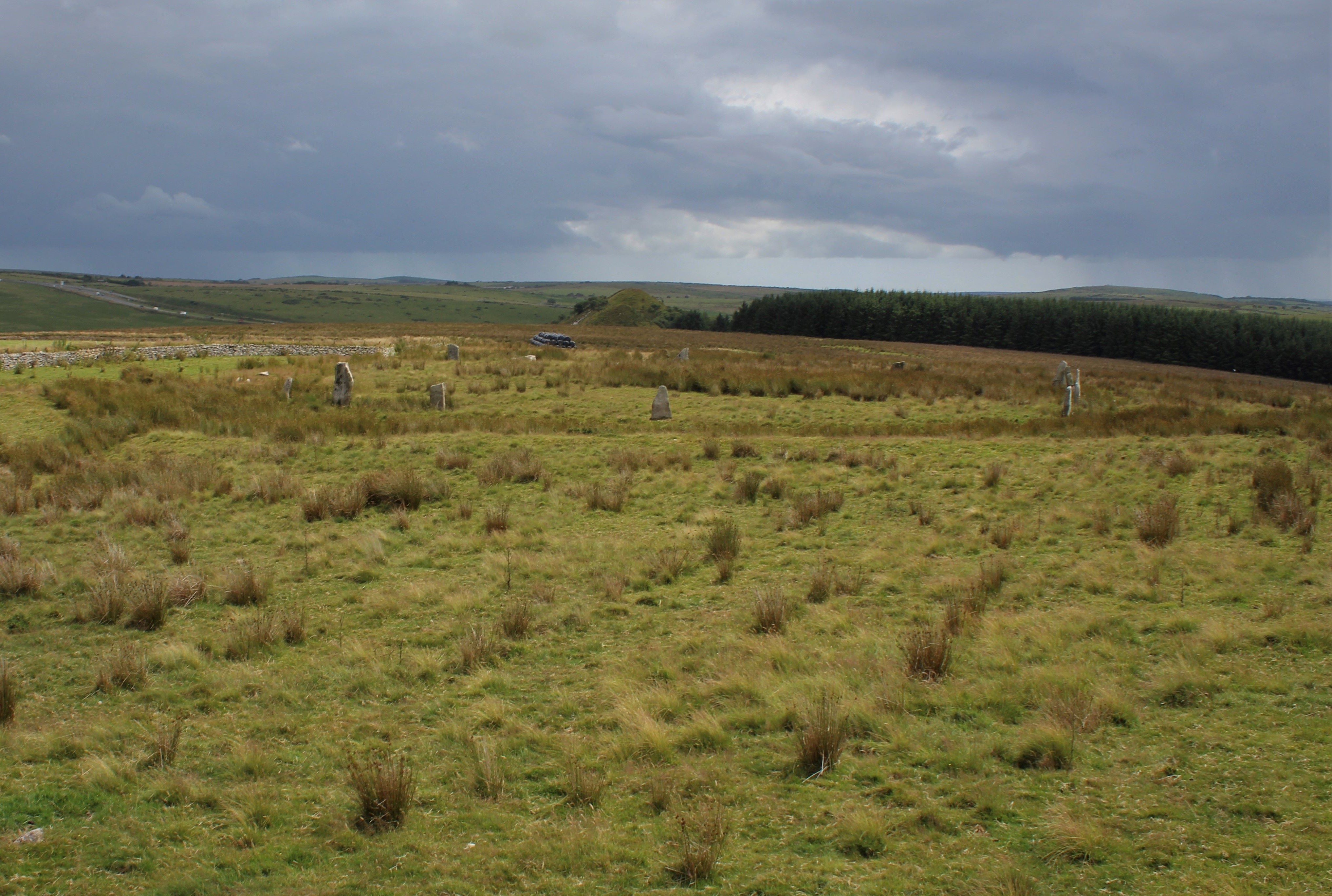
Stripple Stones viewed from Summit of Hawk’s Tor.
Image credit: Mark Johnstone
Stripple Stones viewed from Summit of Hawk’s Tor.

Stripple Stones viewed from W.

N Arc of Stone Circle in Stripple Stones.

W Arc of Stone Circle in Stripple Stones.

NE Triangular Recumbent Stone (42°), c. 6.5 feet long by 2 feet wide in Stripple Stones

S Recumbent Stone (180°), measuring c, 7 feet long in Stripple Stones
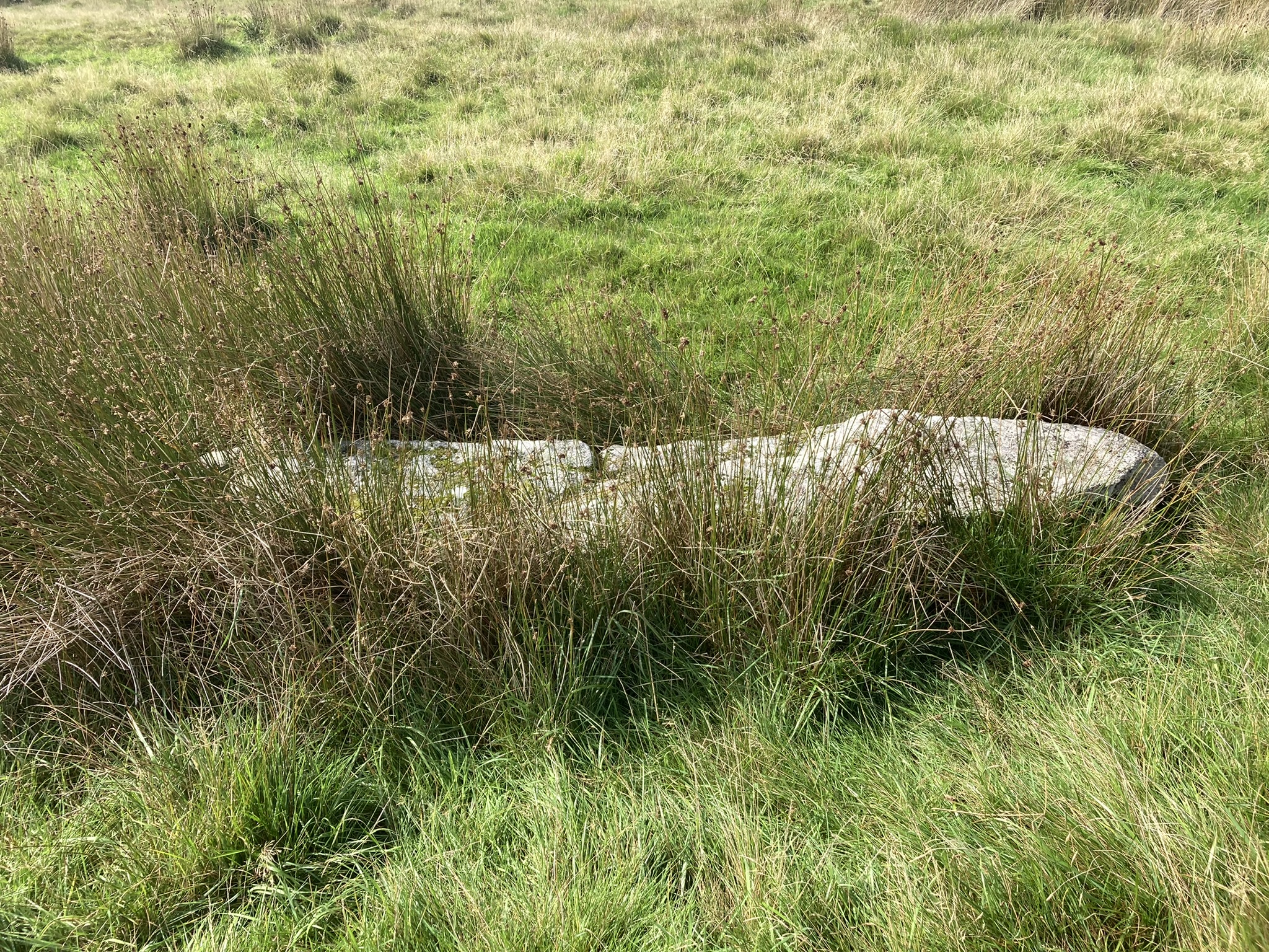
W Recumbent Stone (267°), c. 9.5 feet long in Stripple Stones.

Central Recumbent Stone I (338°), measuring 12 ft long by 33 inches wide in Stripple Stones.

Central Recumbent Stone II (338°), measuring 40 inches long by 12 inches wide in Stripple Stones.

Shattered fragment and stumps on the eastern side of the monument.

The tallest of the re-erected stones, a massive slab of granite with a natural crease.

Two of the re-erected stones, presumably both with corners broken off long ago.

From the west.


The stone postman christened Mick, now with added companions.

Hawk’s Tor behind and a brooding Roughtor and Brown Willy on the skyline to the right.

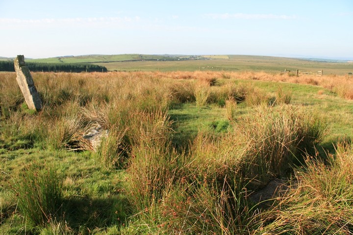
Bank and internal ditch.


Park on the side of the track leading to Hawk’s Tor Farm. Walk NE past the Trippet Stones, through the first gate and across the small stream. You are now in a narrow lane with sheep pens. There are two more gates in this lane (both were tied shut and I had to climb over them). You can then follow either route to the Stripple Stones (the south route is easier going). The land marked in yellow is private, but I believe this route has been given the OK for access to the stones.

Approaching the Stripple Stones & Henge 15/5/2019

Stripple Stones 15/5/2019

Stripple Stones 15/5/2019

The (apparently) recently re-erected Stripple Stones! 15/5/2019
On private land just to the south of Hawk’s Tor on Bodmin Moor stands the Stripple Stones, the only stone circle in Cornwall to be in a henge (a bank and ditch). Originally there were 28 stones of which 15 remain. Some of these are fallen, but most were re-erected during a recent restoration.

On private land just to the south of Hawk’s Tor on Bodmin Moor stands the Stripple Stones, the only stone circle in Cornwall to be in a henge (a bank and ditch). Originally there were 28 stones of which 15 remain. Some of these are fallen, but most were re-erected during a recent restoration.

On private land just to the south of Hawk’s Tor on Bodmin Moor stands the Stripple Stones, the only stone circle in Cornwall to be in a henge (a bank and ditch). Originally there were 28 stones of which 15 remain. Some of these are fallen, but most were re-erected during a recent restoration.

On private land just to the south of Hawk’s Tor on Bodmin Moor stands the Stripple Stones, the only stone circle in Cornwall to be in a henge (a bank and ditch). Originally there were 28 stones of which 15 remain. Some of these are fallen, but most were re-erected during a recent restoration.


Twilight at the Stones.

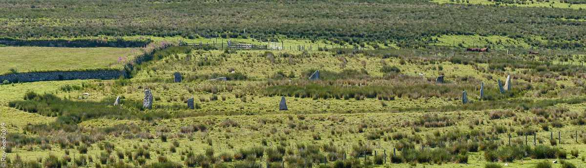
Three out of four Stripple stones, in the distance the short white curve is the farm track that is next to the Trippet stones.

All four Stripple stones, part of the henge in the foreground and Hawks Tor beyond, and Rough Tor far right.

Looking across three of the four Stripple stones. Rough Tor left and Brown Willy on the right.

This is I think the best stone of the group. I shall call it Mick.

The fallen center stone, and a stretch of henge with Haws Tor beyond.

Two of the four still standing stones, the strangely conical hill is I think an old quarrying heap, a good place to appreciate the Stripple stones from though.

Could this be an entrance into the henge or just a break in the bank.
Two fallen, one still hanging in there.

All four stones within their henge, the strangely conical hill is I think an old quarrying heap, a good place to appreciate the Stripple stones from though.

Largest of the four remaining stones, the west stone is about 5ft high.

Eastern Stone looking north towards Brown Willy. “modern” wall can be seen behind stone.


Henge ditch looking west
Visited 10.09.22
Two Stone Circles for the price of one! Trippet Stones & Stripple Stones are a classic double. Hawk’s Tor is a bonus. Stripple Stones were restored in 2015 by The Heritage Trust. A modern wall bisecting the henge was removed, the henge was restored and fallen stones re-erected. The current monument has 11 standing stones & 4 recumbent stones in the stone circle and 2 central recumbent stones orientated towards 338°. The large recumbent central stone measures c. 12 ft by 33 inches. The smaller parallel recumbent central stone measures c. 40 inches by 12 inches.
Pictures of all 17 stones in Stripple Stones are available in Historic England List Entry Number: 1006693 (go to Links).
Directions: Take the St Breward/Temple turn off the A30. Follow the St Breward road for c. 0.8 mile to the 1st crossroad. Turn left and park up on the grass verge after c. 0.2 miles. Walk c. 170 yards NNW to Trippet Stones. Walk NE for 0.3 miles to the corner of the common. Follow the track NE for c. 0.35 miles. Walk SE for c. 0.2 miles to the summit of Hawk’s Tor. The Stripple Stones are located 0.25 miles SE of the summit. My route to Stripple Stones is on OS Maps (go to Links).
An early morning visit this one, the hotel was just a fifteen minute drive away so by 7.30 I was locking the car door and making my way east towards Hawks Tor farm.
No noise or movement was coming from the farm so I just walked right through it, I saw no one and I think no one saw me, unhindered and unchallenged I made good progress. As I started to go up towards the top of Hawks Tor a great pillow of cold white mist swamped the whole area, it held a chill to it, and I began to wonder whether I would be able to find the henge and it’s stones. But the low cloud was short lived, and as it moved away I turned right, away from Hawks Tor, climbed a fence and moved towards where I thought the stones should be. Then out of the thinning mist and green grasses I could see poking up dark shapes, and blammo, i’m here.
I sit for a while on the old wall that is being held responsible for wiping out the west end of the henge and the destruction of at least several stones. But it doesn’t sadden me too much, it is regrettable to be sure, but it’s done, and we have what we have.
The mist is all gone now so I release my camera from it’s bag and start to walk round and round, at least five times round it’s circumference, and regarding the stones in detail, unlike Sanctuary I only counted eight fallen stones including the central stone, there was a couple of stony bits that looked more like bedrock, perhaps they are fallen stones, but they are too bulky and misshapen, not at all like the other fallen stones and not really in the line of the circle.
The henge is indeed worn and mostly filled in but enough remains to recognise it for what it is, I’ve seen henges more worn than this.
Together with the fallen stones and the four good up right ones this is turning into a great site. It is a pity it’s not been better looked after, and some restoration of fallen stones back into their vertical positions would go along way to secure more visitors.
A path leading from the south from the A30 by the old quarry would be nice too, instead of having to sneak through or go round the farm.
Twice I’ve been to the very close by Trippet stones, but only now am I able to spend some time up here, it has been time well spent, and worth the wait. This is a very good site, with much still left to see, there really should have been more pictures of this place before now.
Leaving the henge and stones behind I climb up the Tor of Hawks for a general overview, as you do, and I can see for miles in all directions, this is also the first time ive been able to look at Brown Willy, with out laughing, I mean and be able to identify it as what it is, the highest point in Cornwall, it may be further up than me but I am definitely higher.
The henge sits in the middle of a massive bowl of hills, or rather the Tor on whose side it sits does. I can appreciate why it is where it is.
Ninety degrees in a clock wise direction and I can see the far off Trippet stones, I zoom a few photos pack up and move off towards them, not through the farm this time, there is some activity there now, but down to the west, the same way Sanctuary and Mr Hamhead went, it is a good walk.
The Stripple Stones…Hawks Tor Downs, Blisland, Cornwall. (SX14357521)
Visit date: 5th July 2013
With just two more stone circles to visit on Bodmin’s moors (Leaze would be the last one after this visit) I set out on a beautiful Friday morning to search out the Stripple Stones on Hawks Tor Downs.
This one was of special interest to me because it is a stone circle 47 yards in diameter set within a henge some 58 yards in diameter and the only such one in Cornwall, so I was really looking forward to that moment when you cast your eyes on a new circle for the first time, especially one so special.
I began my walk from the Trippet Stones on Manor Common which reaches down to the main A30 road through Cornwall. The turn-off to the Trippet Stones on the A30 is from the Temple crossroads about four miles from the Jamaica Inn away to the east. Take the right turn signposted St Breward and a mile or so up this moorland road take the road/track to the right at a small crossroad signposted Treswigga to the left. About 200 yards up this gravelled track and the Trippets can be seen on the left. Park just off the track but please don’t drive up to the circle as the ground is very peaty here and cuts up easily.
As the land leading to the Stripple Stones is mainly private you either have to seek permission from the landowner at Hawks Tor Farm at the end of the track, or, take a chance and do what I did and take a round-about route to get there via a well worn working track leading up to the lower reaches of Hawks Tor.
So, from the Trippet Stones and with Hawkstor to the east in front of you away in the distance, I headed off diagonally to the left of Hawkstor Farm until I met the boundary wall/hedge and followed it down to a gate. Lovely old stone walling on the left leading up to the gate. This is the route the local landowner and probably other Commoners take to bring cattle on and off this part of the moor so it is well worn.
Through the gate and begin the walk up a longish track past a ‘working area’ on the left and a series of cattle pens and runs. Note the huge flat upright stones set into the walling on the right alongside a gateway to the right. Two more gates to negotiate (I had to climb both as they were secure to keep the cattle in) then the gate leading onto the open moor.
Ahead of you to the right are the lower reaches of Hawks Tor and it was then that I remembered why I had decided not to bring my Border Collie Chief with me for the first time ever. Gorse, rocks, dense shrub grass…and the possibility of adders! I’d heard on the news just two days earlier that 13 dogs had been bitten over the moors in a month so there was no way I was going to let my normally constant travelling companion risk running the gauntlet here.
A bit of a climb gets you to the top with the usual outstanding views around Cornwall on display. Off to the north are our two national landmarks of Roughtor and Brown Willy and forward of them, Garrow Tor. What tales they could collectively tell of the goings on over the centuries that’s for sure! To the south is the A30 and beyond it Colliford Lake.
From here I walked due south to the base of the Tor until meeting a timber gate leading into a large paddock with sheep enclosed. In the distance but slightly to the left I could just make out the circular shape of the henge and a few standing stones which were well apart. I had only just began to walk toward them when I realised there was a lower fence-line so had to turn immediately left from the gateway I had only just passed through and follow the fence-line until reaching another gate about 100 yards away. Through that then immediately turn right and the Stripple Stones are about 300 yards ahead of you.
Well, the moment had come, but I have to admit to feeling rather disappointed on first close up view as the henge is only these days a mere shadow of its former self. Cattle and mans determination to totally disregard our heritage have played their hand yet again! Just four stones left standing and ten more lying prostrate, including a central pillar, were all I could find from what is believed to have been around 28-30.
Worse was to come. Built right across the north-eastern sector of the stone circle, ditch and bank is a stone and earthen boundary wall/bank which no doubt included the broken remains of those removed stones. It beggars belief that in this landscape of nothingness other than an area of outstanding beauty, the perpetrators of this – what to my mind is a criminal act – could not have avoided the henge altogether.
To me it is quite simple and I no longer accept excuses. Generation after generation of landowners simply don’t care and are prepared to see our past destroyed because it is of no interest or value to them. Even though there are thousands of acres of Bodmin Moor for stock to roam over, nobody it seems is prepared to give up the comparatively small areas of land these circles are built on and erect protective fencing or traditionally built walls in keeping with the environment to keep them safe! This is a henge site for heavens sake and the only one in Cornwall with a stone circle within it. How much more important must a site be before someone takes this matter seriously? Out of sight, out of mind, would appear to be the case here due to its location.
Little remains to be seen now of the ditch or bank as again they are being wiped out by wondering stock. It has almost certainly been accelerated over the past decade as Highland Cattle have become very popular over the moor. These massive beasts are like tanks wondering the landscape with not much standing in their way and particularly noticed near the Trippet Stones circle just a stones throw away on Manor Common. It has been said that the cattle do very little damage to the archaeology taking into account just how long in the main most of the sites have been here, but surely they are living in cloud-cuckoo land if they really believe that! A herd will walk through a stone circle using every stone as rubbing posts if the mood takes them and for every altercation between beasts every stone in their path is in imminent danger due to the soft peaty soil many are erected on!
I took the reverse route back but on descending the Tor noticed farmer workers along the lower track removing cattle from a trailer so hung back for a few minutes. On completion they then drove a quad bike up the trailer ramp before moving off. I thought I was safe but on emerging out of the track-way noticed they had parked up and were letting three or four collies loose for a drink in the stream that passes through at this point. I manned-up for a confrontation and continued walking but other than a cursory glance back by the driver, they paid no further attention to me and drove off.
On reaching my car some 15 minutes later, I was to get the shock of my life, for in the distance I could see and hear the same guys returning both in the truck and quad bike, but this time driving cattle across the common – directly toward the Trippet Stones!
I quickly got out my camcorder and filmed them drive the cattle straight through the stone circle without an apparent care in the world. youtu.be/sYOs73GLvrs
It’s as I have already said, nobody cares! Just one week earlier the Commoners had been warned about driving vehicles and stock through the circle by Natural England so this just proved the total disregard shown by them. On this occasion neither vehicle passed through the circle although the truck was pretty close but the cattle sure did! I am at a complete loss as to why sites such as this can’t be protected efficiently but sympathetically. I reported the incident to English Heritage and sent them the clip of the video but have now all but given up my fight to have these sites protected as nobody listens. The ongoing excuse is always the same…lack of funds, but they seem to be found for other projects felt more interesting and potentially money making!
I feel I should have planted a flag.....the first entry for this site!
The Stipple Stones and henge lie on the southern shoulder of Hawks Tor, just north of the A30 heading towards Bolventor from Bodmin. Infact the constant drone of traffic makes you realise how close you are.
I am not sure how you are legally supposed to access them but I aproached via the Trippet Stones, down into the valley to the left of Hawks Tor farm, through a gate and up an old trackway. This brings you out below HawksTor, climb to the summit then descend towards the south heading for a gate. Once through the gate the henge is ahead slightly to the left.
It consists of four upright stones, plus others that have fallen, inside a shallow ditch. THe central menhir lies fallen and has at some time been cut for moor stone. A wall eats into the eastern side of the henge and over it nothing remains of the ditch.
On a sunny day in June this is a magical site (if you can ignore the traffic noise) but i do wonder what brought man to this site all those years ago, what makes this such a special place?
Details of Stones on Pastscape
(SX 14377521) Stripple Stones (NAT) Henge (NR) (1)
Class 1 Henge (2), being the second largest stone circle in Cornwall. It stands on the south east slope of Hawk’s Tor. There were originally about 28 standing stones of granite up to 10’ in height in a circle 146.5’ in diameter, at an average distance of 16.5’ apart. Only 4 were still standing at the time of the excavation (3) and comparison with Lukis’s plan 1879 showed that there had been considerable pillage during the intervening years. The circle and platform were surrounded by a bank 224’ in diameter, almost concentric with the stones. The broad and irregular inner ditch at the north east to west became indistinct at the south side. (2-4)
The same number of stones remain (ie 4 standing, 10 recumbent) as shown on Tregelles’ stylised plan. The gap in the west is probably the original entrance; breaks in the south bank appear to be modern. The henge is severely mutilated by cattle, particularly in the north quadrant. Surveyed at 1:2500. (5)
A badly ruined circle-henge with stones of local granite.
Originally a circle of 28 stones with a diameter of 147 ft stood inside a ditch and external bank measuring about 224 ft from crest to crest and broken by a single entrance at the WSW. The bank has curious semi-circular apses in it at NNE, E and WNW.
The 1905 excavation showed that the stones were only poorly supported and several post holes to the north east and west of the centre stone may indicate where trial posts had stood before the position for the tall central pillar was determined. (6)
Stripple Stones, at 280m above O.D. on a shelf of an otherwise very slight south east slope. Partly in open moorland and about one fifth of perimeter in enclosed pasture. Unaltered in recent years, an no obvious diggings by treasure hunters. Damage by cattle continues.
Included in catalogue and distribution map of Neolithic sites in Cornwall. (8)
Roughly circular enclosure defined by slight bank and ditch with single entrance and circle of standing stones on terrace on the south-east side of Hawks Tor at c 275m above OD. (9)
In Macleans guide to the “Deanery of Trigg Minor” published in 1876 he states that the Stipple Stones were first mentioned in the time of Queen Elizabeth the First.
Stripple Stones Route on OS Mapping
Stripple Stones on Historic England
Article on the re-erection of several of the fallen stones.
This is a link to a 360° panorama made from the centre of the circle in June 2019 after the re-erection of several of the fallen stones.
The Stripple Stones: Out of sight, out of mind
With just two more stone circles to visit on Bodmin’s moors (Leaze would be the last one) I set out on a beautiful Friday morning to search out the Stripple Stones on Hawks Tor Downs. This one was of special interest to me because it is a stone circle 47 yards in diameter set within a henge some 58 yards in diameter and the only such one in Cornwall, so I was really looking forward to that moment when you cast your eyes on a new circle for the first time, especially one so special.


