Showing 1-20 of 136 links. Most recent first | Next 20 
Dig One (2021) at Boden Fogou.
|

Webpages dedicated to the ongoing excavations at Boden Fogou. We were treated to a tour of the site today.
I hadn't realised that the resurrected Time Team did a dig there in 2021.
|
Brief Statement on Rescue Recording of an Eroding InterTidal Peat Bed Containing Prehistoric Worked Timber and Human and Animal Footprints
February 2011
Staff from Archaeological Research Services Ltd undertook recording of an inter-tidal peat deposit at Low Hauxley, Northumberland, between the 21st and 23rd December 2010. The work comprised the cleaning (using hand tools) and planning of an area of footprints of both animal and human origin, along with extensive digital photography of the deposit and its context.
|
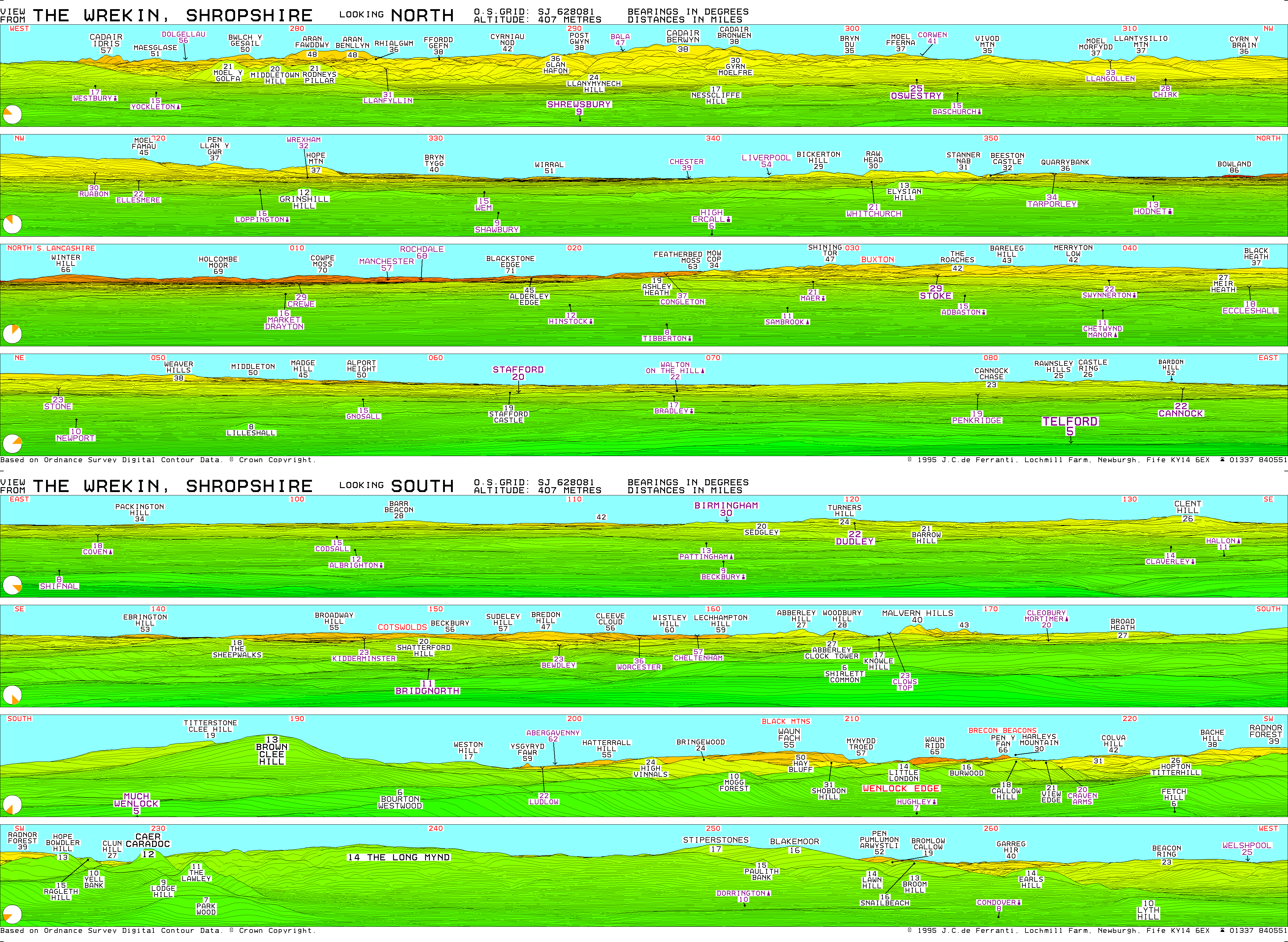
Panoramic diagram of all the hills you can see from the Wrekin.
|
Extensive photos of the excavation of the Braich y Dinas hillfort before it was completely destroyed by quarrying in the 20th century.
|
Excellent website detailing the caves on Great Orme.
Unfortunately it indicates that the cave shown in the images on TMA is Elephant's Cave rather than either of Kendrick's Caves.
|
Comprehensive survey of prehistoric monuments of Denbighshire and East Conwy.
Opens a pdf.
|
New 3D exploration app for Maes Howe from Historic Scotland.
|
The List of Historic Place Names of Wales is a groundbreaking and innovative resource that contains hundreds of thousands of place names collected from historical maps and other sources. It provides a fascinating insight into the land-use, archaeology and history of Wales.
|
Annotated 3D model of Caer Drewyn by Mark Walters
|
Lovely barbed and tanged arrowhead found on Hay Bluff/Pen y Beacon and recorded and shared by PAS.
|
"A field guide to accessible sites
This is an online guide to accessible monuments in Cornwall, compiled by the Strategic Historic Environment Service of Cornwall Council. It is aimed at anyone with an interest in the countryside, heritage and culture of Cornwall, who wish to get out and experience the wealth of the county’s remarkable sites and monuments.
The range of monuments that can be visited in Cornwall encompass every period of history and prehistory, and reveals insights into changing patterns of agriculture and subsistence, ritual and religion, industry and transport – in short, all facets of human culture over a timespan exceeding 10,000 years.
New sites will be added periodically, so please check back in the future for any newly added sites. Any new additions will be highlighted as such on this page."
|
Website dedicated to Hembury fort, including details of conservation and management.
|
Analysis of the possible origins of the cultivation terraces on Markinch Hill.
|
Latest updates from Ffion Reynolds on the 2016 season landscape project, including excavation of Bronze Age cairn close to the chambered tomb and new cupmark discoveries on the ridge.
|
Detailed report based on evaluation and excavation at Tinkinswood, including the "quarry" area and Bronze Age barrow, led by CADW's Ffion Reynolds.
|
Site devoted to the caves of the peninsula, with a gazetteer of sites.
|
Blog about the well, with photos, directions and some folklore.
|
"The first British Neolithic representational art? The chalk engravings at Cissbury flint mine"
Article by Anne M. Teather
|
Deer antler found on beach at Tywyn thought to be 6000 years old.
|
Showing 1-20 of 136 links. Most recent first | Next 20 |
"The fleeting hour of life of those who love the hills is quickly spent, but the hills are eternal. Always there will be the lonely ridge, the dancing beck, the silent forest; always there will be the exhilaration of the summits. These are for the seeking, and those who seek and find while there is still time will be blessed both in mind and body." Alfred Wainwright
"The movers move, the shakers shake, the winners write their history. But from high on the high hills, it all looks like nothing." Justin Sullivan
Elsewhere: Mastodon
|
|

._Copyright_Mr_Jim_Saunders._(FindID_161354).jpg)