|
|

|
|
Waulud's BankEnclosure
|
|
|
|
Images (click to view fullsize) |
|
|
Fieldnotes |
|
|
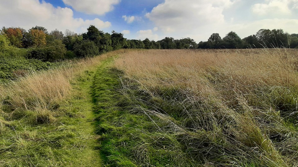
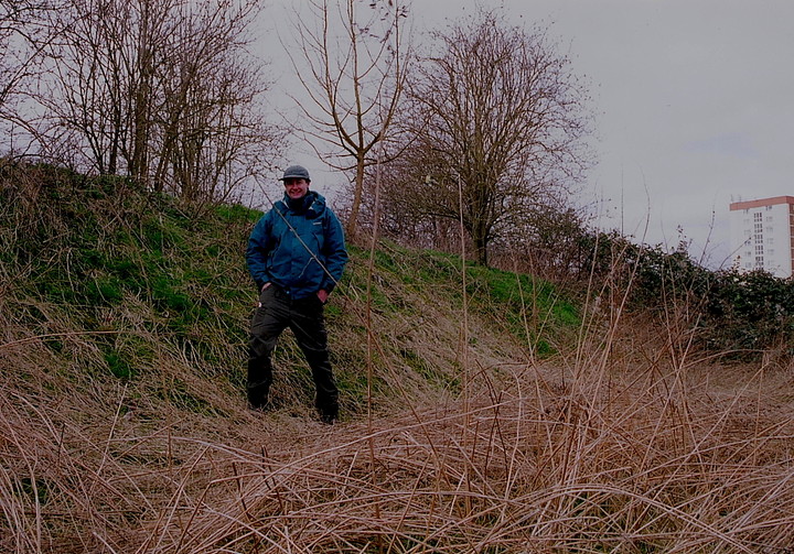
Visited 25.5.15 Directions: Next to the 3 horse shoes roundabout, near the train station. Plenty of parking available. We found the site with surprisingly little difficulty. Karen stayed in the car (Dafydd now watching a DVD on the ancient Greeks whilst Sophie was enjoying Annie). I first walked up to the (naturally) vandalised information board and read it as best I could. I then headed up the grass bank which is part of the perimeter of the enclosure. Let’s be honest, this is not the nicest of places. The urban sprawl of Luton represents (to me) all that is bad in modern day ‘progress’. It is not a pretty sight. However, this small oasis does at least provide some respite from the dreariness of the surroundings. The further you walk into the field the better it seems. Car noise is replaced by bird song and (if you try hard enough) you can start to forget about the ‘progress’. At least there was no litter to be seen – which was another surprise. From the top of the bank you can appreciate what an elevated position this is - IF you can erase the modern buildings etc this would have been a locally prominent location. I was able to trace large sections of the bank across the grass and out of the trees. This would have been a very large area. There is not a huge amount to see here and to be honest had the site not appeared in Julian’s big orange book the chances are I wouldn’t have gone out of my way to visit. However, this is an important site and as such is worth the effort. I am glad I visited but not a place I am likely to make a return visit. |
Posted by CARL 27th May 2015ce |
|
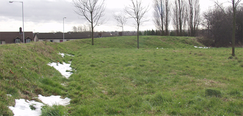
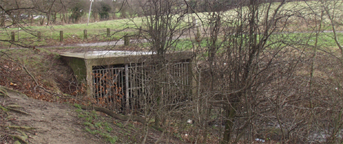
The book states that this is in the middle of a housing estate, and so it proved to be. There were a couple of burnt out motor vehicles and so much urban rubbish that archeaologists of the future will truly have a 'field day' here... The source of the Lea is trapped in a concrete and steelwork cage, as mentioned by Julian. It's very difficult to make out the layout of the bank itself from the lea-side. The course of the bank is more obvious from the road, but looks just like the soundproofing embankments so loved of modern planners. The only difference between the bank and its modern equivalent is that there are no houses behind it. This post appears as part of the weblog entry Urban Landscape
|
2nd February 2003ce Edited 2nd February 2003ce |
|
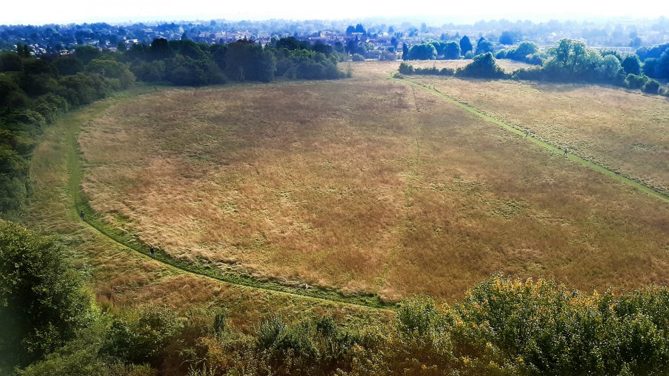
Waulud's Bank earthworks lies on the edge of the Marsh Farm Estate in Leagrave, Luton. The River Lea runs close by, its source located within the vicinity of the surrounding marsh. Archaeological excavations date the site at around 3000 bc. therefore the site probably began its origins in the Neolithic period. The 'D' shape of the site is almost identical to that of Durrington Walls nr Avebury, however the Durrington Walls site has an 'A' road cutting it in half and is almost certainly from a later period 2800-2200bc. than the Waulud's Bank site. Documents have placed Julius Caesar at the source of the River Lea, and a substantial roman villa once existed in Bramingham Road which borders Waulud's Bank. Interestingly the site is in close proximity to the Icknield Way and about 5 miles in distance from Watling Street in Dunstable - also famous for its Roman History. The building at the edge of Waulud's Bank was a one time farmhouse called Marsh Farm house the occupants probably owned the acreage that later became the Marsh Farm Estate. |
Posted by wbmft 19th January 2003ce Edited 19th January 2003ce |
| A very enigmatic earthwork, which curves around the river Lea forming a semicircular area just over 7ha. No entrances or extrenal features are known. But stone age pottery and flint arrow heads have been found. Finds are in the Luton Museum |
Posted by GuttBucket 17th January 2002ce |
Folklore |
|
|
The English Heritage record claims that the name Waulud is a corruption of Wayland; that is, the same chap who would shoe your horse at Wayland's Smithy. I am tempted to say that Waulud's Bank is where he kept all those silver coins, but that would be silly. The record also mentions that 'some early writers' believed Waulud's Bank to be a place called Lygeanburgh (the similarly sounding Limbury is nearby). This was a settlement supposedly captured by Cuthwulf, (Prince of Wessex?) in 571AD. Though it probably was unrelated in reality. I assume the name is pronounced rather like 'Warlord'? If any tales exist among local kids, this must surely influence the type of story told? |
 Posted by Rhiannon
1st September 2004ce |
Miscellaneous |
|
|
Details of site on Pastscape Fairly well preserved semi-circular earthwork enclosure of possible Neolithic or Iron Age date. The enclosure, surveyed in 1994 by RCHME, comprises a bank and external ditch, with no surviving entrances. It measures roughly 300 metres north-south by 200 metres east-west, and encloses about 5.5 hectares. The western side is formed by a later field boundary, which has truncated the enclosure. The earthworks delimit an area of low-lying ground on the eastern side of the River Lea, which rises from five springs located just inside the northern edge of the enclosure. There have been three separate episodes of excavation at the site. In 1953, small quantities of prehistoric pottery, including four sherds of Grooved Ware, were recovered from the ditch fill. A small hollow outside the ditch was tentatively identified as a Neolithic hut. In 1971, Grooved Ware sherds were found in the lower ditch fill and on the old ground surface under the bank. The ditch also contained Beaker, Peterborough, Iron Age and Romano-British sherds. In 1982, a pit, said to have been sealed beneath the bank, was excavated. It contained the skeleton of a young pig plus late Neolithic flint flakes. The pig produced a very recent radiocarbon date, and may have been associated with a piggery which once existed near the site. Geophysical survey in 1985 produced mostly negative results, although some possible pits were recorded outside the enclosure. The site has generally been regarded as a Neolithic henge-type enclosure, largely on the basis of the 1953 and 1971 excavations, and by analogy with the larger henge enclosures such as Mount Pleasant (Dorset), Marden, Durrington Walls, and Avebury (all Wiltshire). However, the evidence for dating is hardly unequivocal at present. There is considerable evidence for Iron Age activity in the immediate vicinity as well as stray finds of Neolithic and Early Bronze Age date. The earthwork has been scheduled as a Neolithic enclosure by English Heritage. |
 Posted by Chance
4th January 2015ce |
The article is strongly entitled 'British Archaeology and Philistinism'. He's very cross and frustrated.At the end of the second week in July two contracted skeletons were found in a nurseryman's grounds near the famous British camp at Leagrave, Luton. Both were greatly contracted; one, on its right side, had both arms straight down, one under the body the other above; the other skeleton lay upon its left side, with the left hand under the face and the right arm straight down. Both were probably female, and upon the breast of one was a fine bronze pin seven inches long with three pendant ornaments, and three discs of bronze, one plated with gold. Other bronzes of great interest were found with the second skeleton.From 'Nature' v72 (27th July 1905, p 294/5). |
Posted by Rhiannon 27th September 2012ce Edited 27th September 2012ce |
In Faunthorpe's Map of Beds (published by Philip, 1873) it is called "Wayland Bank," in the Tithe Book (1844), "Wallards," in the Ordnance Survey Map (1886), "Waulud's Bank;" being popularly named "Waller's Bank."Henry Cobbs' 'Luton Church, historical and descriptive' (1899). |
Posted by Rhiannon 20th December 2009ce |
| Waulud's Bank is described in the literature I have read as being a 'ritual' or 'ceremonial' site - yet the ditch is *outside* the bank - surely more akin to the defensive/settlement type of earthwork? |
Posted by Sifaka 11th February 2005ce |
|
The 'Five Springs' originate at the NW corner of the site, then the stream flows south along the western boundary of the enclosure. This was originally all marshy, but it was drained when the railway line was constructed in the 19th century (I wonder, can you see anything of the site from the train?). According to the EH record on MAGIC, Waulud's Bank is truly a unique type of monument – but it draws comparisons with the 'henge enclosures', Marden particularly, as a stream too forms part of its boundary. They're not the same though, as Waulud's ditch (some 15-20m across) is on the outside, whereas Marden et al.'s are on the inside. And another possible difference is that Waulud's Bank has no opposing hengey-type entrances – but maybe the evidence for those just hasn't been found yet. The site has rarely been ploughed and under all the modern muck there's probably all sorts of clues waiting to be found – maybe especially in the boggy bits where organic material can survive. Also, although you might be horrified by the amount of 21st century detritus round here, it seems it's hardly a new issue. The ditch on the northern side of the site was enlarged in the Roman period, at which time a lot of 2nd century junk got dumped into it (as mentioned in Dyer's 'Southern Britain'). |
Posted by Rhiannon 1st September 2004ce Edited 7th October 2004ce |