|
|

|
Argyll and Bute (Islands): Latest Posts |
Kinuachdrachd (Cairn(s)) — Fieldnotes |
|
This is quite literally the end of the road as far as Jura is concerned. The track ends at Kinauchdrachd at a farmhouse that both looks like it's being restored or fallen down. What has almost fallen is the small houses of the small hamlet that once existed here. Just beyond these buildings is a flat area which looks as if it has been farmed, this houses the two cairns. The cairn at NR 7053 9885 is the largest being 11m wide and 1m tall. It appears to have a capstone or large stone on top. Apart from that it is grass covered. Canmore say no kerbs, I think a couple poke their heads through the turf. The smaller cairn is only 15m to west and is also grass covered but a very lovely shape. It is almost 5m wide and 0.6m tall. Both cairns have tremendous views over the Sound Of Jura and Scarba (island), the other side of Corryvreckan. Now for those going on to Corryvreckan viewpoint to see the standing wave, whirlpools and Scarba finding the path can be a nightmare. We scrambled up the steep slopes through woods to eventually reach the path heading north, however there is a much easier way. Go back to the farmhouse and head down the track for 50m, look for a broken stump on the west side, this marks the beginning of the route to the viewpoint. The post, which once upon a time had a sign, has all but rotted away, look up the hill and path can be spied but the beginning of it cannot be seen. The ferns on Jura have had a glorious year!. The track is fairly easy, over a couple of wee hills till the viewpoint. Despite the length of the walk, this is a stunning place, stunning scenery and a lot of prehistory on the way. Give yourself plenty time and leave earlyish, by the time we arrived back to the car it was still daylight, by the time we arrived back in Craighouse it was dark. Great walk, great sites, and feet reasonably fine. Visited 28/07/2021. |
13th October 2021ce |
Barnhill (Kerbed Cairn) — Fieldnotes |
|
I couldn't get to the dun but I could get to the Kerb Cairn. Keep following the road north until, at a severe corner, you go past the entrance to Barnhill. There is a flatter area of grass as the road heads north, look east you'll see a gap in the dyke which leads up the small hill of Glac A Chneamha. Along with nearby Cnoc an t-Sabhail, the area Barnhill was built on, there is evidence of small hamlets and a now long gone population. Bronze Age people lived here and maybe they had a small village here as well. I couldn't find that, I found some of the medieval 'but n ben's and more importantly for here the cairn remains in place. Once on top of Glac A Chneamha head south over fairly uneven ground, nothing to bad. The site is almost 5m wide and 0.3m tall. One kerb remains in place, its near neighbour topped and another on the east also toppled. However in the centre there is perhaps a cist, hard to tell with all the vegetation. Jura has had a remarkable summer for ferns! Absolutely stunning views, the Sound of Jura, mainland Scotland, to the north Scarba's east coast. Onwards and north. Visited 28/07/2021. |
4th October 2021ce |
Rubh' an Truisealaich (Stone Fort / Dun) — Fieldnotes |
|
Continuing northwards we eventually looked down into the valley in which Barnhill stands, the house made famous by George Orwell who wrote 1984 here and by some of his exploits on boats. The house is still owned by the Fletcher family who rented it to Orwell, and at the time of this visit the house was occupied by members of the Fletcher family. To get to the site would have meant walking across their land and nobody was at home. So pictures of the dun perhaps broch from afar. Tremendous site for such a monument with superb views south. East and north views of the Sound of Jura and the Scottish mainland. Would have been nice to get closer. Visited 28/07/2021. |
4th October 2021ce |
Cnoc Nan Darag (Chambered Cairn) — Fieldnotes |
|
For a long time it was considered that the chamber cairn at Cladh Chlainn Iain was the only monument of this type on Jura. It looks like the Jura Heritage Society might have found another. After clambering my way cross country, from the cairn at Cnoc A Chuirn, following the stream I landed in, Allt a'Chuirn Mhoir north westish I regained the firmer ground of the track near a bright blue coloured bridge, Follow the track as it meanders north crossing a bridge near a hut, keep going until until a silver coloured bridge. The site is beyond, hiding behind a small mound and to the west. Using the casual eye I made the site 15m long, 4m wide and perhaps 2m tall. Stone work can be seen a points all round the cairn especially at the eastern end. Nowadays this a lonely lonely place, in the past and perhaps not to distant past quite a lot of people lived here. Sadly apart from residents at Barnhill the area is population free except for wildlife. However it has tremendous views especially north east to the Scottish mainland. Worth a visit! Visited 28/07/2021. |
4th October 2021ce |
Cnoc A' Chuirn Mhoir (Kerbed Cairn) — Fieldnotes |
|
Cnoc A' Chuirn Mhoir - Hill Of The Big Cairn, is the perfect description for this site which is 200m south of the summit. The minor road ends at Lealt with a small car park, an information board and signpost indicating the distance to places further north (distances in miles). Barnhill 1984 Kinauchdrachd 5 Corryvreckan 7 However our first site of the day would be the 17m by 1m kerb cairn. It is set in a truly spectacular location. The hill of the same name to the north, clear views over the Sound of Jura to the Scotland's mainland. There are kerbs on the west side, under the heather there are kerbs on the north. Despite the remoteness, plenty people lived here in the past and there is some evidence of this as some stone rubble was dumped on the north part of the site. From Lealt follow the track north until the deer fence veers north east. Follow this and it will lead straight to the cairn. This is the proper way, unfortunately for me I headed cross country from the track heading east as a bridge in the distance came into view. Unfortunately for me as I made my way across the valley I found out why there was a bridge as I promptly walked straight into the Allt a Chuirn Mhoir burn. Nothing deterred from the site - stunning! Visited 28/07/2021. |
25th September 2021ce |
Bridgend (Hillfort) — Fieldnotes |
|
Take the road the leads east just to the north of the hotel and as the land flattens out climb over the gate into the field. This field is immediately behind the hotel. Sadly there isn't much to see except for natural defences on the west. However, placed to the south of the River Sorn, it would have been a great vantage point. Head back to ferry to Jura time. Visited 27/07/2021. |
24th September 2021ce |
Rockside (Stone Fort / Dun) — Fieldnotes |
|
Sometimes my job, my favourite drink and prehistory all occasionally collide, sometimes unintentionally. On a previous visit to Islay I'd visited The Oa with its American Monument (erected after the tragic events during 1918), this time to complete research for a new album I'd visited the Kilchoman Military cemetery, overlooking Machir Bay, scene of another tragedy. On leaving the cemetery I, of course, had to visit the local distillery to sample some of the local holy water. Just to west of the distillery's car park there is Rockside Dun, one of many prehistoric sites in the area. The most likely entrance is to the south east of the 30m by 10m site. Not much remains of the ramparts apart from some fallen stone all round the wee hill, 6m high, that is overlooked by some serious looking cliffs. Great wee site, the local drink would be sampled later on Jura. Visited 28/07/2021. |
24th September 2021ce |
Dun Nosebridge (Hillfort) — Fieldnotes |
|
Dun Nosebridge truly is a stunning place and it can be seen from Mulindry, where we parked. The gentleman at Mulindry Old Schoolhouse, also proved very helpful, with place name pronunciations, and also allowed to park immediately behind his car, i.e. The Oa / Kilchoman. Nosebridge is as it reads :-) Cross over the River Laggan, and take the track heading east, a nice easy walk which leads straight to fort. The cairn at Caisteal Mhic Dhomhnuill is also nearby, is at the top of the hill immediately north. However the main attraction soon comes into view. The fort can be easily climbed from the west but the main stone lined entrance is on the east. Three huge ramparts cover north, three, perhaps more cover east and west and to the south natural defences, a cliff face. There must have been a huge amount of work carried out here, no doubt in later centuries the fort was used for more agricultural purposes. At the moment, thankfully, it seems to be left alone. Truly stunning site. Visited 28/07/2021. |
17th September 2021ce |
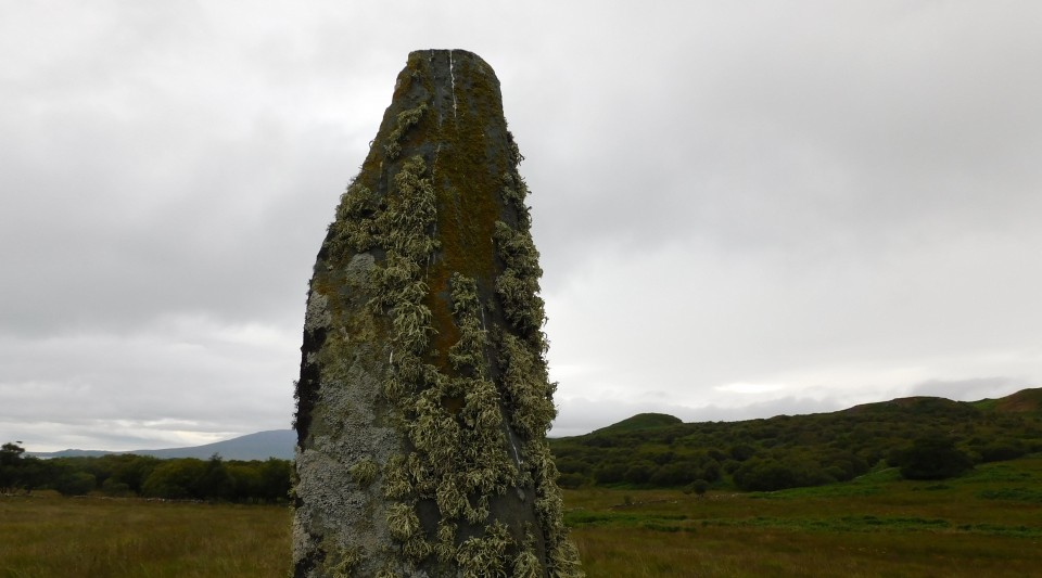
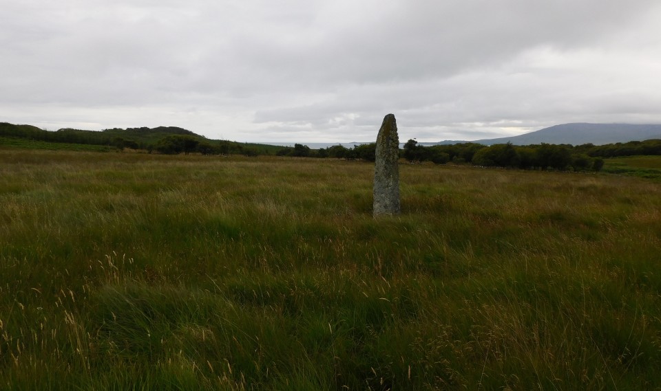
Strone (Standing Stones) — Images (click to view fullsize) |
|
1st September 2021ce |