|
These caves were excavated in 1908 and were found to contain an iron knife, a socketed spearhead, bone button, parts of glass armlets, a whetstone, a deer horn pick, a bronze pin etc. In other words- remains of several occupations. All the finds relate to the early Iron Age. The wall built across the larger cave is reckoned to date between the 4th and 12th centuries.
|
|
An Iron Age date has been suggested for these cairns. Apparently to the west of the cemetery are the remains of other small cairns that were excavated in 1902. These contained cists that had been previously disturbed and only found to contain pottery fragments. One undisturbed cairn contained and oval grave with three human skeletons. At the northern end of the same cairn was found four human skulls and other skeletal remains. Other finds picked up from around the site included pieces of decorated and cinerary urns, flints, arrowheads, knives and scrapers all of which are in the National Museum of Scotland.
|
|
This circle is part of the South East Perthshire Stone Circle Trail (along with Colen Wood and Wolfhill). I got a leaflet about the Trail from Perth Museum (01738 632488). I couldn't see the way in to the woods so asked the very happy farmer at the cottage next to the woods. Just before the end of the trees at the west there's a stile over the fence from the B953 roadside. Walk north and you'll see the green 'Stone Circle' sign.
|
Two sites in the Lothians which were *destroyed relatively recently*;
Muirhouses Standing Stone
Was at NT539787 (Sheet 66)
Described as a massive boulder- 4.5 ft high by a whopping 11'4" in girth. It stood on the summit of a low broad ridge. It was destoyed sometime between 1913 and 1975. It was said to have marked the northern limit of a battle which was fought here in the 9th Century.
Muirhouses South Standing Stone
Was at NT540780 (Sheet 66)
Described as being approx 4.5 ft high by 9' in girth. The stone slanted to the north at an angle of 33 degrees. The base was packed with small boulders. It stood on the crest of a low ridge and was said to have maked the southern limit of the aforementioned battle.
This stone was destroyed in *January 1989*!
These stones stood approx 700 metres from each other and were intervisible.
|
|
A three sided stone approx 10 ft high by 3 ft breadth.
|
|
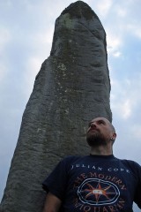
Approximately 3.4 m high and almost square in section (like many of the monoliths in this part of the country).
|
|
This stones about 9 ft high and about 6 ft in girth at base where it is roughly rectangular in plan. It's been made from red sandstone. There are three cup marks on its west face. Deep grooves on the base of the stone were caused by a steam-plough!
|
|
AKA Clach na Voile or the Stone of Fury. Rectangular block of granite approx 1 m N/S, 0.7 m E/W and 1.1 m high.
|
|
A large fuel tank was reported lying on top of this rock by the OS in 1969. By 1974 however, someone had the foresight to shift it! Approx 20 cup marks, 14 of which occur in two non-parallel rows of seven cups each.
|
|
A large rock outcrop with 18 cup marks and three cup and ring marks.
|
|
A hump backed boulder measuring approx 2 X 1.3 X 0.5 m high. At least 25 cup marks most of which are approx 7 cm in diameter, but one whopper of 14 cm diameter and 6 cm deep.
|
|
AKA Allt Kinardochy. An isolated boulder with 12 cup marks on the upper horizontal surface.
|
|
A cup marked stone that has been built into the SW gable end of a cottage. It has 10 cup marks. Apparently in 1967 there was a report of a small stone (1'6"X1'2") lying near the back door of the cottage. However, a later OS report from 1974 was unable to loacte this- gone for good?
|
|
On a small square rock outcrop a single cup mark sits- measures approx 7 cm in diameter.
|
|
This site was re-discovered in 1994 by the Keltic Research Society. There was 28 single cup markings, three cup and ring markings and two cup markes with two ring markings each. Apparently this site was re-turfed and is probably now lost???
|
|
Five cup marks (one of which with a single ring approx 6" in diameter) on a stone approx 4 ft long, 3 ft wide by 2 ft high.
|
|
Ten cup marks on a large boulder were reported in 1886, but a later OS visit in 1974 reported that the boulder had split and five of the cups have disappeared. The boulder was originally approx 9 ft long, by 7 ft wide and 4 ft high.
|
|
Whilst sorting through pictures, fieldnotes etc for a sites in this area I realised that along the north and east sides of the Magickal Mountain, Schiehallion, there are at least nine sites of cup (and ring) markings. There are probably many more hidden away (see Garth Estate 3 for example) awaiting re-discovery. To the hills ;)
|
|
UPDATE! I was speaking to someone the other day who visited this site. Turns out it isn't as obscure and difficult to reach as I thought. They have spent Midsummers night at Wallaces Cave and there's apparently a very steep path from the cave heading right to the carvings. I'll try this the next time- no more wading through rivers and scrambling up through mud ;)
|

|
The RCAHMS entry states that this site is 'a most unusual and well-preserved series of carvings occur on the vertical faces of a shallow recess on an almost inaccessible rock ledge above the River Esk. Circles, spirals, triangles, an S-motif, a shield and other geometric marks and grooves are incised on the rock. These figures are quite unlike the more normal Bronze Age markings, and may be of a different date.' The entry then goes on to state that an OS visit of 1954 discovered that it was not possible to examine the symbols closely due to being sited in a precipitous cliff. Then in 1975, the OS were unable to even locate the site.
|
|
|
|