'Of greater age than any of the other memorials of the Parish and the Ward are the four Standing Stones of Liberton. One of them is in the old burial-ground at Niddrie-Marischal. Another stands close to the Old Dalkieth Road at Craigend, in what was once known as Kirklands, now a market-garden. The third, formerly built into a wall at Nether Liberton, has been re-erected on the King's Knowe, behind the stables of The Inch. The fourth is in the grounds of Mortonhall.'
From 'The Fringes of Edinburgh' by John Geddie (date unknown) pages 155-156.
These four stones are Niddrie, Ravenswood Avenue, Cat Stane at the Inch and the Bore Stane.
Around this stone there are 32 streets named in its honour.
|

The plaque reads;
'The Buckstane. This marchstone, a relic of feudal times, occupied a site on the Roman road about 250 yards north from this spot. By tradition the name was derived from the stone having marked the place where the buckhounds were unleashed when the King of Scotland hunted in this region.
|
The plaque, which has now disappeared, used to read;
'Catstane. After various vicissitudes this stone was erected here in 1919, near its original site.' This was from an OS field report of 10 March 1954. They also noted that its original position could not be established
|
|
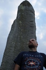
This stone originally (according to the RCAHMS) stood near the junction of Dalkeith and Liberton Roads at Nether Liberton Farm. It was moved at the beginning of the 19th century and lay in a field until 1891 when it was built into a wall on Gilmerton Road. It was then set up in its present position by the owner of Inch House.
|
|
The stone has been moved a few yards from its original position that was where the road now is. It was set in concrete and protected by an iron railing during the time of the construction of the housing scheme.
|
|
This stone is a slab of coarse red freestone almost 5 foot by 2 foot and nearly 1 foot wide. It's badly weathered and none of the cup marks are thought to be artificial. There is no evidence that there was a muster on the Borough Muir in 1513. It's been suggested, from its dimensions, that this is possibly the cover of a cist.
|
|
This site may possibly mark the Winter Solstice sunset as the sun sets in the Paps of Jura.
|
It is thought that the fortifications were built first (pre-Roman Iron Age), then the broch (around 100 to 140 CE) followed by the settlement under the pax Romana of about 140 to 180 CE. The broch and some of the smaller structures were excavated numerous times before 1879. All finds are now in the National Museum of Scotland. These consist of a stone whorl, piece of jet ring, an amber bead, fragment of translucent glass bracelet, bones, teeth and oyster shells.
The fort consists of a double rampart up to 4.5 metres in height in places and covering an oval area of around 135 metres by 75 metres. The overall diameter of the broch is around 27 metres which is very large for one of these sites.
|
|
This broch was excavated up to 1920 and some find including stone whorls, vitrified beads etc were made- all now in the National Museum of Scotland. Also found were a ring of post holes in the middle of the site that may have supported upper floors/roof.
|
|
Excavation finds here included querns, stone cups and spindle whorls. All of the finds are now in the National Museum of Scotland.
|
|
A small amount of cremated bone was discovered next to one of the stones (as in Carse Farm I). Also similar is the fact that one of the now recumbent stones has four cups marks on its upper horizontal surface. The other recumbent stone has two cup marks near the top.
|
Next to the inner surface of the NE stone a pit was found filled with charcoal, earth and compacted cremated bone. Also found was a collared urn with incised geometric ornamentation. The SW stone was re-erected sometime in the 20th C.
The four stones form a rectangle measuring 3.9m and aligned WSW/ENE.
|
|
An OS report from 1980 suggest that this site may be a defended homestead which was adopted from a megalithic structure. This report also states that the evidence for a cairn is dubious.
|
|
This stone was only rediscovered in 1903 buried at a depth of 8 foot (!) a few feet from the main stem of the yew tree- it's now set up about 25 foot from its original site and has nine cup marks on its upper surface.
|
Carse Farm II
Burl lists this site as a four-poster, but only one of the stones still stands, two other (now recumbent) stones lie in an arc. An OS report from 1975 states that this site is definitely the remains of a large stone circle.
|
|
This stone was re-erected in 1889 with the smaller stone fixed to the top at that date. About 1830 the stone is said to have been brought down from higher up the hill because visitors to it were damaging the surrounding crops. It has been suggested that the name 'Final's Grave' should apply to the original site and 'Fingal's Stone' to the stone in its present position.
|
|
The stone is reported to have been found on the hill above the old parish church at NT2452 6303. Apparently there was said to have been a second cup and ring marked stone at the old parish church, but this is now lost.
|
Eight figure map co-ordinates for the six outcrops at this complex site;
NS 8588 8840
NS 8851 8831
NS 8571 8797
NS 8552 8816
NS 8555 8811
NS 8597 8826
|
|
In the 'Standing Stones of the Lothians' by Adam McLean the Lochend Stone outlier is noted as being in the right position to act as an equinox sunrise marker.
|
|
In Adam McLeans 'Standing Stones of the Lothians' (1977) this site is described as being 'in a remote region'. Not anymore as it's only two mins out of Gorebridge which is slowly becoming indivisible from Edinburgh.
|
|
|
|