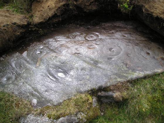
Ten cup marks on a large boulder were reported in 1886, but a later OS visit in 1974 reported that the boulder had split and five of the cups have disappeared. The boulder was originally approx 9 ft long, by 7 ft wide and 4 ft high.
Articles
Sites within 20km of Wester Litigan
-
Garth Estate III
description 1 -
Garth Bothy
description 1 -
Garth Cottage
description 1 -
Garth Lodge
description 1 -

Garth Lodge
photo 3description 1 -

Drumcharry
photo 9description 2 -

Glengoulandie
photo 18description 3 -

Finduie Wood
photo 6description 1 -

Comrie Bridge
photo 4description 3 -

Fortingall
photo 29forum 1description 11link 3 -

Fortingall Churchyard
photo 11forum 1description 4 -

Carn na Marbh
photo 6description 2 -

Carse Farm I
photo 17description 6link 2 -

Carse Farm II
photo 5description 4link 2 -

Croft Moraig
photo 59forum 4description 12link 3 -

The Appin of Dull
photo 7description 4 -

Newhall Bridge Two Poster
photo 23forum 1description 5link 3 -

Kenmore Church
photo 1description 2 -

Bridge of Lyon Cairn
photo 10forum 1description 4link 4 -

Bridge of Lyon Standing Stones
photo 17description 2link 2 -

Bridge of Lyon
photo 7description 2link 1 -
Cuigeal-Mairi
description 1 -

Remain Rock
photo 4description 1 -
Nether Tullicro
-

Tullichuil
photo 3description 1 -

Braes of Taymouth
photo 1description 1link 2 -

Braes of Balloch
photo 5description 1link 2 -
Coille Dhubh
description 2 -

Tombuie Cottage
photo 3link 1 -

Braes of Foss
photo 22description 2 -

Cromrar
photo 7description 1 -
Croftmartaig
description 1 -

Balmacnaughton
photo 9link 1 -

Balhomais
photo 9description 5link 3 -

Clach an Tuirc
photo 1description 3 -

Clach-na-Cruich
photo 2description 1 -

Oakbank Crannog
photo 1forum 1description 3 -
Castle Menzies Cursus
description 1 -

Acharn Burn
photo 6description 2 -
Craig Hill
photo 47forum 1description 10link 2 -

Craig Kynachan
photo 3description 1 -

Falls of Acharn Stone Circle
photo 42description 9link 2 -
Tombreck
description 1 -
Tombreck
-

Black Burn
photo 36description 8link 2 -

Remony Burn
photo 12description 1 -
Boltachan Burn
-

An Torr
photo 8description 2link 1 -

Coilleaichur
photo 4description 1 -

Urlar Burn
photo 1description 1 -

Glassie
photo 5description 1link 2 -

Tullochroisk
photo 1description 1 -

Cloanlawers
photo 25forum 1description 3link 2 -

Pitmackie
photo 5description 1 -

East Tempar
photo 4description 2 -
Tom-an-Droighne
-

Carn Tulach
photo 5forum 1description 3 -

Lundin
photo 4description 1 -

Upper Gaskan
photo 22description 4link 1 -
Shian Burn
-

Shian Burn
photo 3 -

Over Bohespic
photo 4description 2 -

Garrow
photo 3description 1 -

Lundin Farm
photo 31description 7link 2 -

Lurgan Farm
photo 5description 1 -

Lurgan
photo 32description 7link 3 -

Tomintianda
photo 3description 1 -

Knoc-Na-Eaglais
photo 1link 1 -

Machuim
photo 37forum 3description 11link 3 -

Coire Thaochaidh
photo 10description 1 -

Clach na Boile
photo 8forum 1description 1 -

Balnabodach
photo 8forum 1description 1link 2 -

Middleton of Derculich
photo 5description 1 -

Turrerich
photo 8description 1 -

Grantully Hill
photo 1description 1 -

Balendune
photo 4link 3 -

Easter Croftintygan Farm
photo 4description 1 -

St Adamnan’s Cross
photo 7description 2 -

Pitcastle
photo 3 -

Creagan Fheadaire
photo 3description 1 -

Balnasuim
photo 11description 1 -

Coire Cireineach
photo 5description 2 -

Clach a’ Mharsainte
photo 6description 4link 1 -
Kinaldie
description 1 -

Queen’s View
photo 4description 1 -

Na Carraigean
photo 32forum 1description 8 -
Clach Ghlas
description 3link 1 -

Allt A’ Choire Chireinich
photo 4link 1 -

Tullich Hill
photo 2description 1 -

Gleann Da Eig
photo 5description 1 -

Gleann Da Eig
photo 3description 1 -

Loch Freuchie
photo 5description 1 -

Tullypowrie
photo 6forum 1description 2 -

Clach Na Buidseach
photo 2forum 1description 1 -
Tombreck 1-2
-

Haugh of Grandtully Farm
photo 12description 3 -

Wester Kinloch
photo 7description 1link 2 -

Craggantoul
photo 4description 1link 2 -

White Cairn
photo 4description 1link 1 -

Carie
photo 7description 1 -

Pitnacree
photo 18description 4 -

Clachan An Diridh
photo 48description 13link 4 -

Fincastle Farm
photo 4description 1 -

Dundavie
photo 2description 1 -

Clach Na h-Iobairt
photo 15description 1 -

Clach na h’ Iobairte
photo 15 -

Tulach Hill
photo 6description 1 -

Tomour
photo 18description 3link 1 -

River Almond
photo 19description 5 -

Kiltyrie
photo 11description 2 -

Clach na Tiompan
photo 1description 1link 1 -

Clach na Tiompan
photo 19description 3link 1 -

Kiltyrie
photo 2description 1 -

Clach na Tiompan
photo 20description 4link 2 -

Creag Odhar
photo 3description 1 -

Strathgarry
photo 4description 2 -

Clach Na Croiche
photo 18description 4link 2 -

Ardtulichan
photo 5description 1 -

Innercochill
photo 2description 1 -

Ardtulichan
photo 2description 1 -
Ballinreigh
description 1 -

Ardtulichan
photo 2description 1 -
Greenacre
-

Faskally – Pitlochry
photo 28description 5 -

Clach na h’ Iobairt
photo 7description 2 -

Craigiedun
photo 6description 2 -

Corrymuckloch
photo 15description 2link 2 -

Dunfallandy
photo 3description 3 -

Killiecrankie
photo 13description 4 -

Blarliargan
photo 1