
Craigbirnoch Central SE Cairn viewed from S.
Image credit: Mark Johnstone
Craigbirnoch Central SE Cairn viewed from S.

Craigbirnoch Central SE Cairn viewed from W.

E Half of Craigbirnoch Central SE Cairn viewed from W.

W Half of Craigbirnoch Central SE Cairn viewed from E.

Field Clearance Stones in NE Quadrant of Craigbirnoch Central SE Cairn viewed from W.
Craigbirnoch Central SE Cairn is located c. 300 yards NE of the junction of Craigbirnoch Farm Track with the New Luce to Barrhill single-track road. It is c. 70 yards E of a passing place (NX 17641 69180) on a sharp corner in open boggy moorland. The round cairn, listed as Canmore ID 61402, measures c. 14 yards in diameter and 2 feet high. The W half of Craigbirnoch Central SE Cairn has an irregular grassy surface in contrast to the lower E half, which has scattered field clearance stones deposited on its grassy surface. A quarried hollow in the NE quadrant has been filled in with medium sized clearance boulders.
Craigbirnoch Central SE Cairn is one of a cluster of cairns E of Craigbirnoch Farm. Craigbirnoch Central NW Cairn is located c. 70 yards NNW of Craigbirnoch Central SE Cairn.


Quarried Hollow in Centre of Craigbirnoch S Cairn viewed from W.

Craigbirnoch S Cairn is located c. 350 yards ESE of Craigbirnoch Farm junction with the New Luce to Barrhill single-track road, in Dumfries and Galloway. The round grassy mound, measuring c. 17 yards in diameter and 4 feet high, lies c. 150 yards down an E slope next to a low stone wall. There are no stones visible on the surface of the cairn. The centre of Craigbirnoch S Cairn has been quarried, leaving a roughly circular hollow measuring c. 5 yards in diameter. Canmore 61421 has details of Craigbirnoch S Cairn. It is one of a cluster of cairns E of Craigbirnoch Farm.


Hollow in Centre of Gallop Hole Cairn viewed from N.
Visited 07.01.23
Gallop Hole Cairn is located on the W edge of Haggstone Moor in South Ayrshire. It was identified as the remains of a possible burial cairn by RCHAMS in 1981. Gallop Hole Cairn is a grassy oval mound measuring 7m (E-W Axis) and 4.5m (N-S Axis), reaching a height of 0.4m according to Canmore ID 60882. The S Arc is preserved as a grass-covered bank. The only stones visible on the cairn are two stones embedded in the N Arc. The centre of the cairn has been excavated, leaving a hollow in the centre.
The monument comprises a large rock outcrop into which a vestry was excavated in 1825, to accommodate the parish minister while he conducted openair services.
Pulpit Rock, or Clach nan Tarbh (the stone of the bulls), lies some 2km south of Ardlui. In 1825 parisioners living in the northern part of the Parish of Arrochar complained of the distance that they had to travel to church services, some 13km each way. The Minister, the Reverend Peter Proudfoot, responded to his parishioners’ complaint saying that if they would build him a vestry he would come and preach to them on certain occasions. The parishioners cut and then blasted a hole in the rock large enough to accommodate the Minister, an Elder and the Precentor.
The shelter in the rock formed the vestry. It had a wooden door and was reached by a flight of steps. A wooden pulpit was fixed to a platform bolted on to the side of the rock. Services were held during the summer months for about 75 years until 1895 when a mission church was established in Ardlui. During the services the congregation sat on the ground around Pulpit Rock.
When the West Highland Railway was built it passed to the west of the rock, so avoiding this religious landmark.
Historically the monument is of national importance as a relatively late example of an open-air preaching site, and is a rare example of the modification of a natural site by blasting to provide a vestry.
Source: Historic Environment Scotland
The above information is taken from Pulpit Rock on Ancient Monuments website.

Osmigarry Standing Stone viewed from NE.

Osmigarry Standing Stone viewed from SW.

Osmigarry Standing Stone viewed from W.

Osmigarry Recumbent Stone viewed from SW.
There is a standing stone on the SE verge of the A855 Portree road c. 50 yards NE of the Skye Museum of Island Life. Osmigarry Standing Stone is a broad irregular pillar reaching c. 5 feet high. The stone has gravitas and the patina of antiquity, but it has no provenance. It is not marked on OS Mapping or listed in Canmore. Despite this, I think it’s physical presence merits a listing as a standing stone. A recumbent stone, c. 4 feet long lies on the NW verge of the A855, opposite Osmigarry Standing Stone. Perhaps it was originally erect, one of a pair of standing stones.


Directions: Take the B7044 Colmonell turn off the A77 on the S end of Ballantrae. This road is narrow with very few passing places. Follow the road for c. 2.8 miles to reach Finnart Cottage. There is a muddy parking space c. 50 yards E on the right side. Knockdolian path starts c. 30 yards E from here. The path climbs steeply NW up a field towards a gate which leads to Knockdolian summit ridge. Knockdolian cairn is located on the summit. An OS Trig Point has been supplanted in the centre of the cairn. My route can be viewed on Knockdolian Cairn.
Directions to Cruise Back Fell Fort: Take the W turn to Glenluce off the A75. Turn left for New Luce after 0.2 mile. Stay on this road for c. 4 miles to reach Cruise Farm. Walk NE along the SUW for c. 250 yards to a gateway. Littlepark Cairn is visible c. 0.25 miles SE on a ridge in the field. Continue SE towards a gateway in the stone wall. Follow the line of the stone wall S for c. 250 yards to Cruise Back Fell Fort on the summit of the fell. My route is viewable on Cruise Back Fell Fort.
Directions to Cruise Back Fell Fort: Take the W turn to Glenluce off the A75. Turn left for New Luce after 0.2 mile. Stay on this road for c. 4 miles to reach Cruise Farm. Walk NE along the SUW for c. 250 yards to a gateway. Littlepark Cairn is visible c. 0.25 miles SE on a ridge in the field. Continue SE towards a gateway in the stone wall. Follow the line of the stone wall S for c. 250 yards to Cruise Back Fell Fort on the summit of the fell. My route is viewable on Cruise Back Fell Fort.
Directions: Arnsheen S Cairn is c. 250 yards SW of a lay-by at NX 27713 77179 on the B7027 Barrhill road. Walk c. 50 yards N along the road to reach two large fenceposts on the W margin of the forest. Head W into the trees along a forest ride. This green lane intersects with a forest ride heading SW. Follow this rough path for c. 200 yards. This boggy route becomes drier as it approaches the forest clearing in which the Arnsheen Cairns are located. Wellies and a walking stick are recommended.
Directions: Arnsheen S Cairn is c. 250 yards SW of a lay-by at NX 27713 77179 on the B7027 Barrhill road. Walk c. 50 yards N along the road to reach two large fenceposts on the W margin of the forest. Head W into the trees along a forest ride. This green lane intersects with a forest ride heading SW. Follow this rough path for c. 200 yards. This boggy route becomes drier as it approaches the forest clearing in which the Arnsheen Cairns are located. Wellies and a walking stick are recommended.
Directions: Take the narrow lane signed for Works Traffic at NX 0662 7380 off the A77 between Glen App Church and Haggstone. After c. 0.6 miles park up in a lay-by at NX 0603 7311. Walk SW along the Stranraer Coastal Path for c. 0.5 miles to reach a gate into the rough pasture which contains Haggstone Moor Cairn. My route is viewable on Haggstone Moor Cairn.
Directions: Take the narrow lane signed for Works Traffic at NX 0662 7380 off the A77 between Glen App Church and Haggstone. After c. 0.6 miles park up in a lay-by at NX 0603 7311. Walk back to the private road to Glen App Wind Farm. Follow this track for c. 0.5 miles and turn left. Walk NE along the track to the third reflecting pole on the left of the road. Walk 38 yards NE from this point to reach a lay-by on the right. On the left side of the road there is a large tree stump and a solitary spruce c. 5 yards NW along a vague path. Haggstone Moor Standing Stone lies 1 foot from the base of the tree at NX 06485 72626.


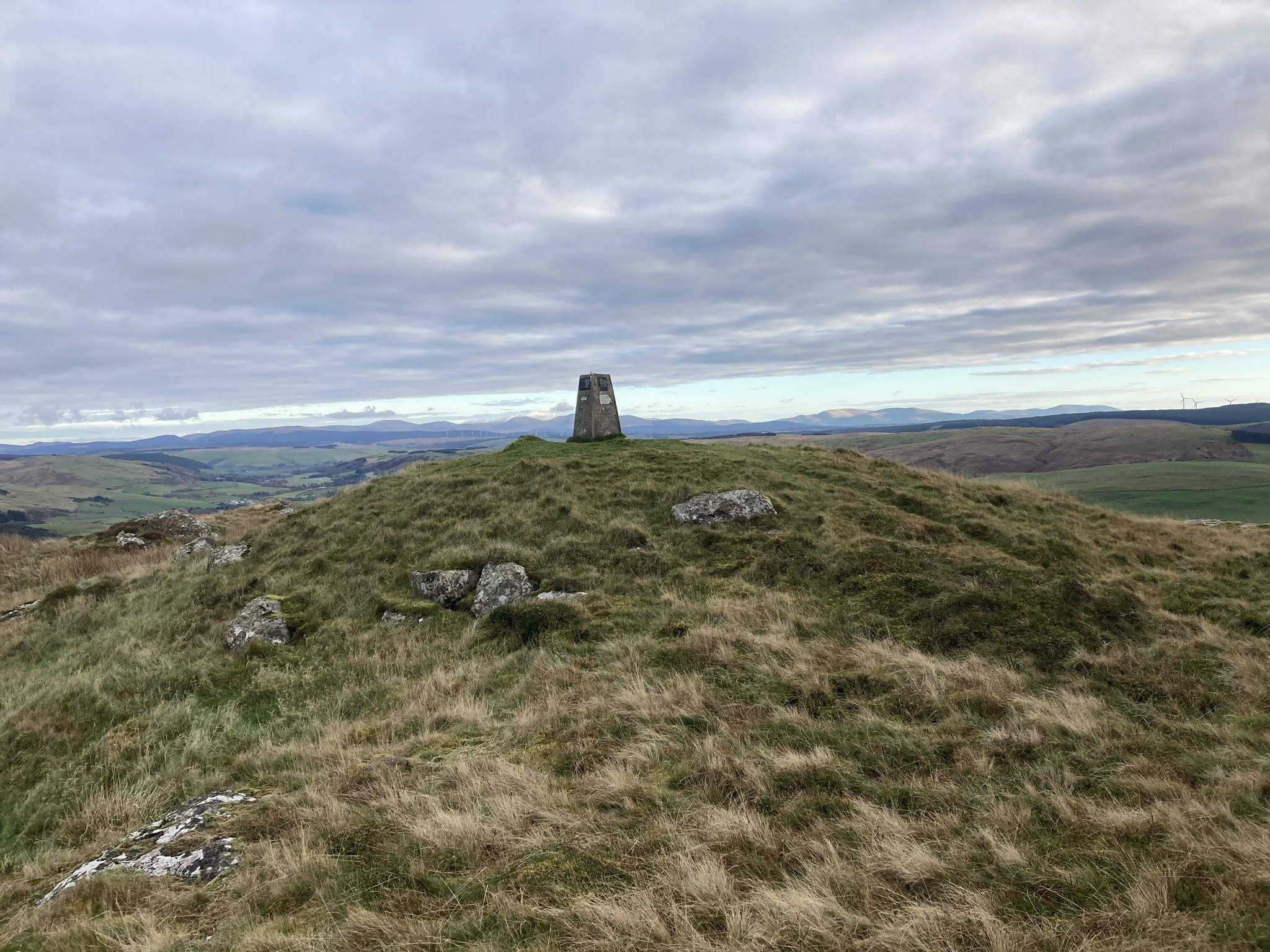

Trig Point on Knockdolian Summit Cairn viewed from NE.


Location of Haggstone Moor Standing Stone viewed from SE.

Haggstone Moor Standing Stone viewed from NE.

Haggstone Moor Standing Stone viewed from NE.

Haggstone Moor Standing Stone viewed from NE.

Irregular SE End of Haggstone Moor Standing Stone.