Nice page by the local council about the site includes maps, what to expect and find pictures.
juamei

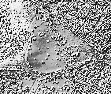
Open Source Environment agency LIDAR
Image credit: © Environment Agency copyright and/or database right 2015.
pastscape.org.uk/hob.aspx?hob_id=879402
A circular enclosure c60m in diameter was examined. Pottery and bronze metal-working moulds from the primary ditch silts indicate a Late Bronze Age date. Later features include a Saxon cremation and inhumation cemetery and Saxon or later post-hole building. (1)
Further grass and cremations were located bringing the total of burials to c150. One of the inhumations was enclosed by a small ring-ditch. Four more Saxon buildings were identified, belonging to at least two phases, together with a number of pits and other features. (2)
Excavation of a circular cropmark enclosure at Springfield, confirmed a Late Bronze Age date for the enclosure. The interior of the enclosure was totally excavated, providing a good plan of all features which had survived subsequent activity at the site. Late Bronze Age features included several post-hole structures, and the post-holes of the revetment for an internal bank. Also located were features and finds of Neolithic/Early Bronze Age and Roman date, an Early Saxon cemetery and a Late Saxon settlement. (3)
HAMBLEDON HILL, DORSET,
ENGLAND.
Excavation and survey of a
Neolithic monument complex and
its surrounding landscape
Volumes 1 & 2
Roger Mercer and Frances Healy
Its interesting to look back at my notes from years past on the ground, staring in a state of confusion at the earthworks. Turns out this hill was a massive neolithic complex. 2 definite, 1 probable and 1 maybe causewayed enclosures (1 central, then 1 on each spur) plus 3 causewayed cross banks sepearating the spurs from the central enclousre. Plus 2 long barrows. Then they abandoned it and headed North-West to build a gert large cursus.
Have a look at the link I’ve added for (many) further details.

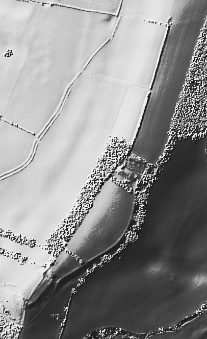
Open Source Environment agency LIDAR
Image credit: © Environment Agency copyright and/or database right 2015.

Open Source Environment agency LIDAR
Image credit: © Environment Agency copyright and/or database right 2015.
Open Source Environment agency LIDAR
Image credit: © Environment Agency copyright and/or database right 2015.

Open Source Environment agency LIDAR
Image credit: © Environment Agency copyright and/or database right 2015.

Open Source Environment agency LIDAR
Image credit: © Environment Agency copyright and/or database right 2015.

Open Source Environment agency LIDAR
Image credit: © Environment Agency copyright and/or database right 2015.

Open Source Environment agency LIDAR
Image credit: © Environment Agency copyright and/or database right 2015.

Open Source Environment agency LIDAR
Image credit: © Environment Agency copyright and/or database right 2015.
Open Source Environment agency LIDAR
Image credit: © Environment Agency copyright and/or database right 2015.

Open Source Environment agency LIDAR
Image credit: © Environment Agency copyright and/or database right 2015.

Open Source Environment agency LIDAR
Image credit: © Environment Agency copyright and/or database right 2015.

Open Source Environment agency LIDAR
Image credit: © Environment Agency copyright and/or database right 2015.

Open Source Environment agency LIDAR
Image credit: © Environment Agency copyright and/or database right 2015.

Open Source Environment agency LIDAR
Image credit: © Environment Agency copyright and/or database right 2015.

Open Source Environment agency LIDAR
Image credit: © Environment Agency copyright and/or database right 2015.

Open Source Environment agency LIDAR
Image credit: © Environment Agency copyright and/or database right 2015.


Open Source Environment agency LIDAR
Image credit: © Environment Agency copyright and/or database right 2015.

Open Source Environment agency LIDAR
Image credit: © Environment Agency copyright and/or database right 2015.

Open Source Environment agency LIDAR
Image credit: © Environment Agency copyright and/or database right 2015.

Open Source Environment agency LIDAR
Image credit: © Environment Agency copyright and/or database right 2015.

Open Source Environment agency LIDAR
Image credit: © Environment Agency copyright and/or database right 2015.

Open Source Environment agency LIDAR
Image credit: © Environment Agency copyright and/or database right 2015.

Open Source Environment agency LIDAR
Image credit: © Environment Agency copyright and/or database right 2015.

Open Source Environment agency LIDAR
Image credit: © Environment Agency copyright and/or database right 2015.

Open Source Environment agency LIDAR
Image credit: © Environment Agency copyright and/or database right 2015.

Open Source Environment agency LIDAR
Image credit: © Environment Agency copyright and/or database right 2015.

Open Source Environment agency LIDAR
Image credit: © Environment Agency copyright and/or database right 2015.

Open Source Environment agency LIDAR
Image credit: © Environment Agency copyright and/or database right 2015.

Open Source Environment agency LIDAR
Image credit: © Environment Agency copyright and/or database right 2015.
historicengland.org.uk/listing/the-list/list-entry/1020710
The monument includes the best surviving part of a prehistoric field system, comprising a number of field banks and associated clearance cairns, all surviving as low earthworks located on a gently sloping clifftop overlooking Lyme Bay. Although not precisely dated, the fields are small and roughly square which suggests an Iron Age origin, with usage perhaps continuing into the Roman period, before the fields were encapsulated within larger medieval or post-medieval field boundaries. The fields lie just to the west of Berry Cliff Camp, a hillfort which is believed to date from the Late Bronze Age to the Early Iron Age, and the subject of a separate scheduling (SM29637). The field system is defined to the south by lynchets (field banks and scarps resulting from prehistoric cultivation techniques). These lynchets occupy a narrow strip of clifftop about 270m in length with a maximum width away from the cliff edge of about 100m. Although it is likely that the field system once extended further inland, modern farming techniques have removed all upstanding traces apart from those close to the cliff. The visible remains also include a series of scarps and banks with many of the scarps lying parallel to the cliff edge whilst the banks lie for the most part at right angles to it. Where surveyed in 1989 by the Royal Commission on the Historical Monuments of England (RCHME), the banks were found to be between 2m-4.5m long and 0.5m-2m wide. Together, the banks and scarps define five or six small fields. Associated with the fields are a number of stone cairns some of which lie on the field banks. These cairns, of which there are about a dozen, are considered to be the result of field clearance and are probably contemporary with the prehistoric working of the fields; they survive as low earth covered piles of flint and stone. Previous commentators have suggested that they might be prehistoric barrows or burial mounds but there is no evidence to support this view. The prehistoric fields have been worked at later periods, perhaps into the medieval and early post-medieval periods, and incorporated into larger rectilinear fields as is evidenced by a long field bank which runs from the monument to a position to its east and a bank and ditch which clearly cuts across the earlier prehistoric field system where it survives on its western side. All fencing, gateposts, and coastal path waymarkers are excluded from the scheduling, although the ground beneath these features is included.

Open Source Environment agency LIDAR
Image credit: © Environment Agency copyright and/or database right 2015.

Open Source Environment agency LIDAR
Image credit: © Environment Agency copyright and/or database right 2015.


Open Source Environment agency LIDAR
Image credit: © Environment Agency copyright and/or database right 2015.

Open Source Environment agency LIDAR
Image credit: © Environment Agency copyright and/or database right 2015.

Open Source Environment agency LIDAR
Image credit: © Environment Agency copyright and/or database right 2015.

Open Source Environment agency LIDAR
Image credit: © Environment Agency copyright and/or database right 2015.

Open Source Environment agency LIDAR
Image credit: © Environment Agency copyright and/or database right 2015.

Open Source Environment agency LIDAR
Image credit: © Environment Agency copyright and/or database right 2015.

Open Source Environment agency LIDAR
Image credit: © Environment Agency copyright and/or database right 2015.

Open Source Environment agency LIDAR
Image credit: © Environment Agency copyright and/or database right 2015.

Open Source Environment agency LIDAR
Image credit: © Environment Agency copyright and/or database right 2015.

Open Source Environment agency LIDAR
Image credit: © Environment Agency copyright and/or database right 2015.

Open Source Environment agency LIDAR
Image credit: © Environment Agency copyright and/or database right 2015.